STRATEGY AND POLICY COMMITTEE - 6 OCTOBER 2011
←
→
Page content transcription
If your browser does not render page correctly, please read the page content below
STRATEGY AND POLICY
COMMITTEE
6 OCTOBER 2011
REPORT 2
(1215/52/IM)
COBHAM DRIVE TO BUCKLE STREET TRANSPORT
IMPROVEMENTS: SUBMISSION TO NZTA
1. Purpose of Report
The report seeks Committee agreement to the attached submission to the New
Zealand Transport Agency (NZTA) on the proposed Cobham Drive to Buckle
Street transport projects.
2. Executive Summary
NZTA is seeking feedback from the community on proposed projects on State
Highway 1 between Cobham Drive and Buckle Street, consisting of:
grade separation at the Basin Reserve
a second Mt Victoria Tunnel
widening Ruahine Street and Wellington Road.
These inner city transport projects represent a major change in the future urban
form of Wellington, and will improve the accessibility of the central city, eastern
and southern suburbs, and the airport. The infrastructure required will exist for
the long term.
A draft submission has been prepared that highlights support for key features,
and a number of areas where further work is required, or where the proposals
should be revised or refined. The most significant of these are discussed in this
report. For the Basin Reserve, the report recommends that:
option A (a bridge near the Basin Reserve) is preferable to option B (a
bridge further away). This option will require significant mitigation,
reflecting the importance of the location.
NZTA should ensure that the design and construction of option A is
future-proofed so that it will be possible to have an underground option
through Memorial Park in the future, if funding becomes available.
The Council holds the Town Belt as trustee under a 1873 deed of trust (Town
Belt Deed 1873). The draft submission assumes that NZTA will be able to
compulsorily acquire Town Belt land despite the Town Belt Deed 1873. It is also
assumed that, before any compulsory acquisition, NZTA will need to engage
with the Council in its role as trustee. The Council’s response to any specific
acquisition proposal can be considered at that time, including issues around
compensation and mitigation.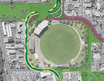
At this stage the draft submission is explicit that it has not been considered by
the Council acting in its role as trustee, and cannot therefore be taken as the
formal position of the Town Belt trustee.

3. Recommendations
Officers recommend that the Strategy and Policy Committee:

1.   Receive the information.

2.   Agree to the attached submission on the proposed state highway projects
     from Cobham Drive to Buckle Street.

3.   Agree to delegate to the Chief Executive and the Portfolio Leader
     Transport: Public Transport and Roads the authority to make changes to
     the submission required as a result of decisions of this Committee, as well
     as minor editorial amendments, prior to the submission being sent to the
     New Zealand Transport Agency.

4.   Note that further engagement with the New Zealand Transport Agency
     will occur during the next phase of planning for these projects, and that
     officers will work with the New Zealand Transport Agency to identify the
     impact of the projects on local roads, the Town Belt, and local
     communities.

4.   Background
In May 2009, the Government has identified seven Roads of National
Significance (RoNS), on the basis that the development of these roads will help
grow the national economy by improving productivity in New Zealand’s largest
cities and surrounding regions.

The NZTA board considered a report titled (SH1) Wellington Northern
Corridor - RoNS endorsement and funding for investigation, design and
property purchase’ on 26 November 2009, and, among other things, endorsed
the Wellington Northern Corridor RoNS from north of Levin to Wellington
Airport which includes the state highway projects between Cobham Drive and
Buckle Street.

The scope of activities approved by the Board as a result of this report includes
determining the form and function of Wellington RoNS elements, the
identification and investigation of options and the selection of a preferred
option for each element, and consultation on the preferred element, prior to
more detailed studies in preparation lodging notices of requirement.

NZTA announced proposals for projects between Cobham Drive and Buckle
Street on 2 July 2011, with community feedback due by 26 August, and agreed
that the Council could have an extension of time to allow Councillors to engage
in the community discussion and receive interim advice from NZTA on the
feedback received prior to finalising the Council position.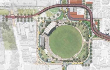
NZTA has outlined the following programme for the next steps:
Late 2011/early 2012 NZTA announces its decisions on the options and
                       publishes a report on the feedback received
Mid-2012               NZTA works with directly affected parties and the public
                       in assessing the environmental effects
Late 2012/early 2013 NZTA lodges Notice of Requirements, probably to a
                       Board of Inquiry
Mid-2013               Detailed design of the transport improvements around
                       the Basin Reserve begins
2014/15                Construction around the Basin Reserve is scheduled to
                       start in either 2014 or 2015 (interim improvements to
                       Ruahine Street, Wellington Road and the Inner City
                       Bypass may also start at this time). The improvements
                       are likely to take two or three years to complete.
? post 2021            The second Mt Victoria Tunnel and Ruahine Street and
                       Wellington Road sections of the projects are scheduled
                       to follow the completion of the Kapiti and Transmission
                       Gully sections of the Wellington RoNS programme

NZTA has indicated that it will lodge the Notices of Requirement with the
Environmental Protection Authority (EPA). It is likely the project will be
deemed to be nationally significant and will be referred to a board of inquiry for
a decision (likely to take approximately nine months).

Decisions made by a board of inquiry cannot be appealed to the Environment
Court, although appeals to the High Court can be made on points of law. Under
the EPA / board of inquiry process the Council does not have its usual role of
making recommendations on a notice of requirement. This means the
submission process becomes the formal opportunity for Council to have
influence on the outcomes. Informally, there will be opportunities for Council to
work with NZTA during the planning and design process once a preferred
option is identified.

5.   Discussion
Councillors received a briefing on the projects from NZTA on 29 June and a
Council workshop was held on 25 August, which included a presentation from
the Architecture Centre on an alternate approach to the grade separation at the
Basin Reserve. Following this workshop, a draft submission was developed
(attached).

The draft submission comments on the proposals included in the public
engagement document ‘Cobham Drive to Buckle Street transport
improvements’. It does not address the rationale for the projects, which was
discussed in the 2010 Regional Land Transport Strategy and the Ngauranga to
Wellington Airport Corridor Plan (N2A Corridor Plan).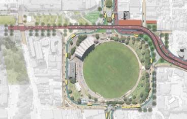
The most complex issue in the draft submission is the identification of the
preferred option at the Basin Reserve. This is discussed below, followed by a
brief discussion on the other elements included in the draft submission, which
are:
Integration
The New Zealand War Memorial Park
The second Mt Victoria Tunnel
The widening of Ruahine Street and Wellington Road
The impact on the Town Belt
The pedestrian and cycling path
Other local impacts
Technical and operational issues
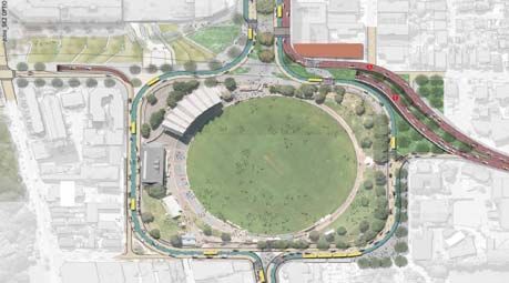
5.1 Basin Reserve Options
NZTA has requested feedback on the following two options:
Option A Option B
NZTA preferred option
A bridge approximately 20 metres A bridge approximately 65 metres
north of the Basin Reserve, north of the Basin Reserve,
approximately 380 metres long, a approximately 440 metres long, a
minimum of 12 metres wide (without minimum of 12 metres wide and a
the cycle/walkway), a maximum of 8 maximum of 8 metres above the
metres above the ground. ground.
NZTA advises that the transport benefits of these two options are similar, but
they have different impacts on urban design and heritage.
Comparing the two options:
option A aligns the proposed bridge structure with the original city grid,
while option B creates a structure that interferes with the built fabric
further north;
both options have large volumes of traffic travelling at grade through
Memorial Park, but option B also involves a major structure curving
across the park;
option A intrudes less into the residential area of Mt Victoria, and requires
fewer properties to be acquired;
option A provides a better alignment for a walking and cycling route on the
bridge; option A has less curves than option B and is therefore contribute to overall
safety;
option B is less visible from inside the Basin Reserve.
Both options are compatible with either an at-grade or a tunnel option through
Memorial Park, although an at-grade option is proposed.
It is recommended that Council’s position is that option A is preferable to option
B.
NZTA has also asked for feedback on whether a cycleway / walkway should be
included on the bridge at an estimated cost of $8 million. A cycleway as part of
Option A would provide a significantly improved route from Hataitai to Buckle
Street (and on to Karo Drive) in comparison with the alternate route passing
under the bridge and on to Kent Terrace. It would also provide cyclists with an
improved connection to Tory Street, which has been identified by the Council as
a key cycle route.
Once a second Mt Victoria tunnel has been constructed there will be no practical
future opportunity to increase roading capacity from Hataitai to the city, and
the management of peak hour congestion will require increased focus on
encouraging some commuters to switch to other modes. If a decision is made
now that the bridge does not include infrastructure to support active modes,
retro-fitting is likely to be required in the future at a higher cost.
It is recommended that Council supports the provision of pedestrian and cycle
facilities on the bridge.
5.2 Effect of Option A
However, while Option A is preferable to Option B, it will still have a significant
number of negative effects. While a bridge will achieve the transport objectives,
it will also cut off the community from the Basin Reserve, reduce local property
values, change the character of an area that would otherwise be redeveloped,
and reduce the quality of life for local residents. The design of Buckle Street and
the bridge structure will have a negative impact on the future New Zealand
Memorial Park, which should be a place of remembrance, contemplation, and
also celebration.
NZTA’s summary of its assessment of Option A is includes the following 1 :
Criteria Option A
Social impacts Effects on schools, community areas minor positive
and facilities, houses and residential
dwellings, community cohesion /
severance, access and connectivity,
promotion of health through active
modes
Built heritage 12 heritage sites in the areas and severe negative
surrounding residential and Kent
Terrace area
1 Feasible Options Report, January 2011, Table 9.20Urban design Environment and ecology, culture minor negative
and heritage, urban structure,
quality of spaces, activity, visual
quality, quality of experience
Officers consider that the assessments of the social and urban design impacts
understate the negative impacts.
NZTA’s $75 million estimate of the cost of option A includes a budget for
enhancing the bridge design to reflect its urban location, and for landscape and
urban design treatments under and around structures etc (totalling $19.8
million). It does not include a budget to address the visual and noise impacts on
the Basin Reserve.
Options for further mitigation include buildings integrated with the bridge
structure, a bridge structure that includes arcades for commercial or
recreational space, alternate materials and finishes, artwork and lighting
treatments on the structure, and extensive screening planting and landscaping.
It is recommended that Council’s position is that option A is not acceptable
without significant further mitigation in addition to that already provided for.
5.3 Other Options
Two options that would remove the requirement for a bridge structure across
Cambridge and Kent Terraces are described briefly below:
Option F Option X
Developed by NZTA Developed by the Architecture Centre
Tunnel links Patterson St to Buckle St Westbound traffic at grade until it
100m trench and 400m tunnel, enters a tunnel at Sussex Street. A
emerging back at ground level between landscaped pedestrian over bridge
Tory St and Taranaki St, with 100m from Memorial Park to Basin Reserve.
trench within Memorial Park. Two way traffic (4 lanes) on the
On-ramp from Sussex Street, with 3 Sussex St side of the Basin Reserve,
lanes in the tunnel after Sussex Street. freeing up land for open space on the
Government House side.Option F Option X
Developed by NZTA Developed by the Architecture Centre
Cost: $200-280 million Cost: $145 -?
Note: this cost has been updated since Note: NZTA has provided an updated
the information provided at the 25 estimate from the one provided by the
August workshop to provide for traffic Architecture Centre to include
from Sussex Street to travel through increase the allowance for:
the tunnel instead of at-grade through a Pedestrian bridge at Dufferin St
Memorial Park additional length of tunnel
the school drop off area
additional allowance for design +
risk
This proposal has only been
developed to a concept level, and
there is accordingly much less
certainty around the likely cost of the
scheme than for the other options.
Both options X and F would allow a much more attractive park, with additional
space, reduced road noise (noise is estimated to vary between 60 dBA and 70
dBA with the state highway at-grade 2 ), and an improved connection between
the War Memorial and the gathering area of the park. These options would also
avoid the negative impacts of an elevated road (outlined in 5.2 above).
Option X would also provide a meaningful green connection from Memorial
Park, through to the Basin Reserve, and across to Government House, and
neighbouring school precincts.
NZTA has provided advice that the transport benefits of option X are 10-15%
less than for other options, and has also raised the following issues:
concerns with ability to fit 4 lanes of traffic into the available corridor in
Sussex Street. This may mean additional property would be required to
provide a median and prevent reduction in footpath width.
the walking and cycling links are grade-separated but involve a significant
change in level (11m) between Cambridge Terrace and Adelaide Rd.
Significant ramp length would be required to accommodate cycling and
wheelchair access.
traffic modelling shows an increase in flows on the alternate route of
Wallace and Taranaki Streets, compared to other options. Congestion on
Sussex Street is likely to result in flows on this route increasing further.
Council officers have reviewed the width of the corridor on Sussex Street and
agree that achieving reasonable minimum cross sectional standards will require
road widening and consequent property acquisition. A four lane road with
significant volumes of traffic would normally have a median to provide for right
turning vehicles to wait, provide some safety for the pedestrians, and give a
useful separation for long vehicles travelling in opposite directions on the
corners.
2 NZTA War Memorial Tunnel Scoping Report pg 95Option X has been developed at a conceptual level, and, while a number of issues have been identified with the design as it stands (such as the issues around the operation of Sussex Street, traffic flow on local streets, the design of the over bridge, and relationship with the Basin Reserve), many of these would be able to be resolved with more detailed investigation and design. At this point, there is not enough information to estimate the extent to which this would increase the cost of option X. A decision to prefer an underground option to option A would require a judgement that avoiding the negative impacts of an elevated road and gaining the opportunity to achieve superior open space outcomes is worth the additional expenditure. The additional expenditure involved would depend on the additional cost of mitigation above the $75 million cost estimate for option A, and the final cost of the underground option. NZTA has advised that these options are unaffordable in the context of the current national land transport programme. It is recommended that the submission requests that NZTA ensures that the design and construction of option A is future-proofed so that it will be possible to construct an underground option through Memorial Park in the future, if funding becomes available. 5.4 Remaining issues The next section of this report summarises the positions included in the draft submission on the remainder of the projects. 5.5 Integration It is recommended that the submission notes the importance of the inner-city state highway projects being planned and managed taking into account the links with the local transport system and other projects identified in the N2A Corridor Plan including the Wellington bus review, Wellington public transport spine study, bus priority projects etc. 5.6 New Zealand War Memorial Park When the National War Memorial was first built in 1932 it commanded a dominant position overlooking the city and would have been highly visible from most areas of the capital. At this time, work on the surrounding area was not completed and when the Tomb of the Unknown Warrior was dedicated in 2004 it became clear the area needed to be developed. In 2005, it was announced that the Ministry of Culture and Heritage would acquire land owned by Transit New Zealand on Buckle Street across the road from the National War Memorial, to create a New Zealand Memorial Park with the intention that the park would join the National War Memorial and the Tomb of the Unknown Warrior as a major focal point for New Zealanders to commemorate sacrifice during time of war. In addition to providing a place for people to gather, the park design would allow for the construction of memorials, particularly from countries with which New Zealand has a close relationship.
A number of designs have been considered for the project, and a design
competition was held, followed by a Government announcement of $11 million
funding in 2007, with a commitment from Council of $2 million. In April 2011,
the Minister of Arts, Culture and Heritage, Christopher Finlayson, marked the
completion of the first phase of development on the new park, which sits across
the road from the National War Memorial.
The current proposal is for the Ministry of Culture and Heritage to develop a
memorial precinct on the War Memorial side of Buckle Street, with NZTA
owning the land on the north side, which would be landscaped as a park and
contain national memorials, but potentially be used for roading purposes in the
future. It is understood that this is intended to allow for undergrounding of the
road if funding is made available in the future.
The objectives of the proposed New Zealand Memorial Park are to:
enhance the setting of the National War Memorial;
provide a space for people to congregate on ceremonial occasions such as
Anzac Day;
create an area in the capital city for the development of new memorials
from countries which New Zealand has a close relationship with;
provide a park to be utilised by day to day users;
retain and enhance the strong heritage values of the area.
It is recommended that the key points in the submission are:
The national significance of the proposed New Zealand Memorial Park
must be recognised in planning for the precinct.
The park should make a positive contribution to the processional route
linking Government House, the National War Memorial, and Parliament.
The objectives of the park (above) must be taken into account in the
design of the road corridor.
The park design should ensure that the connections with Cambridge and
Kent Terraces allows for the future creation of a boulevard.
The Council’s commitment of $2 million is premised on the park
objectives being met in full.
5.7 Second Mt Victoria Tunnel
It is recommended that the key points in the submission are that:
The Council supports the proposed alignment of the Mt Victoria tunnel to
the north of the existing tunnel, and the provision of walking and cycling
facilities in the new tunnel.
NZTA should investigate the relocation of both Etterick House and the
former Catholic Presbytery within the Mt Victoria character area.
The design of the walking and cycling facility in the tunnel should
address the following issues identified by users of the current tunnel:
noise, air quality, width of path, and smell.5.8 Ruahine Street and Wellington Road
It is recommended that the key points in the submission are that:
The Council supports:
o while it has various impacts which will need to be considered, the
option of widening Ruahine Street to the west (which would require
the compulsory acquisition of Town Belt land) is preferable to
widening into the residential area to the east;
o removing the right turn out of Taurima Street to Ruahine Street,
which is unsafe, causes congestion, and allows rat running by people
attempting to avoid queues on Ruahine Street;
o the installation of signals at Goa Street, which will improve access to
Hataitai Park and address the congestion that occurs at this
intersection, particularly at weekends;
o improvements to the intersection of Ruahine Street and Wellington
Road to improve safety while maintaining its current function as part
of a dangerous goods and oversized vehicle route.
That NZTA be requested to:
o investigate mechanisms that will reduce the impact of uncertainty on
affected property owners;
o review the design assumptions in the light of the use of the road and
the adjoining uses in the Town Belt and Hataitai, focusing on
providing a high capacity urban street and reducing the footprint
required.
5.9 Town Belt Issues
The impacts of the project on the Town Belt include:
the loss of land,
landscape impacts
loss of amenity and changes to the character of parts of the Town Belt
adjacent to Ruahine Street
displacement of recreational activities, particularly badminton and the dog
exercise area, and the displacement of Hataitai Kindergarten
loss of mature trees and indigenous vegetation
improved vehicular access at Goa Street,
changes to parking in Ruahine Street and traffic impacts in Moxham Ave
that are likely to impact on the demand for parking for Hataitai Park.
It is recommended that the key points in the submission are
to note the above impacts
to seek to continue working with NZTA to identify options for reducing or
mitigating these impacts.
If the second Mt Victoria Tunnel and widening of Ruahine Street go ahead,
NZTA will need to acquire part of the Town Belt, which is held in Trust by the
Council. During that process the Council will need to make decisions in its role
as Trustee under the Town Belt Deed 1873. It is recommended that the
submission notes that nothing in the submission to NZTA can be taken as the
formal position of the Council as Town Belt trustee.5.10 Pedestrian and Cycle Path
The proposed 6m pedestrian and cycle path adjacent to Ruahine Street and
Wellington Road will also function as a service lane for residential access.
It is recommended that the key points in the submission are:
That Council supports the provision of facilities for walking and cycling, and
in particular supports an off-road cycle facility.
That further work is required to address the following issues:
o The operation and safety at intersections
o The safe operation of vehicular traffic in combination with cycling and
walking.
5.11 Other local impacts
The removal of the right turn at Taurima Street, changes to intersections at Goa
Street, and removal of access from Moxham Avenue and Walmer Street to
Wellington Road will have a cumulative impact that significantly changes the
pattern of traffic on local streets in Hataitai.
It is recommended that the submission supports Council working with NZTA to
ensure that community concerns about local traffic are addressed to the greatest
extent possible.
The loss of space at Kilbirnie Park space will impact on both winter (rugby and
football) and summer (cricket) codes in what is an important space for formal
sports, particularly as the demand for sports fields already exceeds supply. It is
essential that any reconfiguration of this park provides for these sports and the
submission recommends that Council works with NZTA to ensure this can be
achieved.
5.12 Project Timing
At the Council workshop, the question was asked if the second Mt Victoria
Tunnel and widening of Ruahine Street and Wellington Road could be
scheduled earlier. Construction of these projects is expected to commence after
the completion of Transmission Gully and the Kapiti Expressway. On the
schedule announced to date, this would see construction commencing after
2021. This is consistent with the priorities and relative scheduling identified in
the current regional land transport programme.
Bringing forward the duplication of the Mt Victoria Tunnel and Ruahine Street/
Wellington Road projects would entail bringing forward expenditure (estimated
at $430 million based on 2010 costs), which would need to be funded, or
managed by deferring other projects of the same value.
Scheduling for Roads of National Significance projects is considered by NZTA as
a whole, and while NZTA could be asked to review this scheduling to prioritise
these projects ahead of others, as the projects are scheduled consistent with
identified regional priorities it is unlikely that a review would result in changes
to the schedule. The exception would be if there was a change in operational
factors such as a delay in the timeline for gaining consent for a project.The funding constraint could be addressed by a mechanism such as debt funding for the period until funds from the National Land Transport Fund became available. Interest payable under this option could be funded from a variety of sources, including the National Land Transport Fund, tolls, or local contributions. It is unlikely NZTA would consider this unless there was a substantial local contribution. It is not recommended that the submission requests that NZTA reschedules these projects so that they commence earlier. 5.13 Consultation and Engagement NZTA has made available feedback it received from key stakeholders during the public engagement process for the purpose of informing the preparation of Council’s submission. 5.14 Financial Considerations While there are a number of financial implications of NZTA’s proposed projects, there are no financial considerations associated with the development and agreement of the draft submission attached at Appendix One. 5.15 Climate Change Impacts and Considerations The standard economic evaluation of transport projects includes the identification of vehicle operating cost savings and vehicle emission reduction benefits. 5.16 Long-Term Plan Considerations State highway projects are 100% funded by NZTA. The projects proposed by NZTA will require expenditure on elements of the local roading network that are normally part-funded by the Council. Discussions to clarify these impacts and discuss funding and timing have not yet occurred, but there is currently no funding allocated in the regional land transport programme or current LTCCP for Council expenditure arising from these projects, except for a $2 million contribution to Memorial Park. 6. Conclusion NZTA is seeking feedback from the community on proposed projects on State Highway 1 between Cobham Drive and Buckle Street, consisting of: grade separation at the Basin Reserve a second Mt Victoria Tunnel widening Ruahine Street and Wellington Road. These inner city transport projects represent a major change in the urban form of Wellington, and will improve the accessibility of the central city, eastern and southern suburbs, and the airport. The infrastructure required will exist for the long term. A draft submission has been prepared that highlights a number of areas where further work is required, or where the proposals should be revised or refined.
Supporting Information

1)Strategic Fit / Strategic Outcome
The transport strategy includes advocacy for investment in the state
highway network as a strategic priority.

2) LTCCP/Annual Plan reference and long term financial
impact
This report considers a submission to NZTA on SH projects which are
not contained within the WCC LTCCP.

3) Treaty of Waitangi considerations
The proposed NZTA projects have Treaty of Waitangi implications which
should be considered by NZTA. Future Council decisions regarding the
impact of the projects on the Town Belt should be made in consultation
with Mana Whenua.

4) Decision-Making
The decision on what to include in a submission to NZTA is not a
significant decision.

5) Consultation
a)General Consultation
NZTA is undertaking consultation on the proposed projects. The
development of the draft submission takes into account community
views expressed in previous consultation exercises, and information
provided by NZTA on the community feedback NZTA has received to
date.

b) Consultation with Maori
No specific consultation with Maori has occurred during the preparation
of this submission.

6) Legal Implications
There are no legal issues associated with the approval of the draft
submission.

7) Consistency with existing policy
The draft submission is consistent with the transport strategy, and the
cycling and walking policy.
You can also read