City of Onkaparinga Bushfire Management Plan 2020-2024 - Version 2.0 July 2021
←
→
Page content transcription
If your browser does not render page correctly, please read the page content below
City of Onkaparinga
                Bushfire Management Plan 2020-2024

                Version 2.0

                July 2021

Document Set ID: 5296417
Version: 20, Version Date: 14/07/2021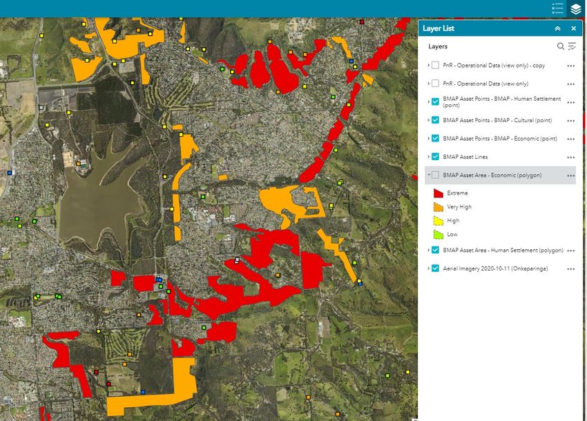
Contents
                1.     Introduction ...................................................................................................................................4
                     1.1      Objectives ...............................................................................................................................4
                     1.2      Considerations in developing the Bushfire Management Plan...............................................4
                     1.3      Relevant Legislation................................................................................................................5
                     1.4      Fire Ban Districts and Fire Danger Season ..............................................................................5
                     1.5      Overview.................................................................................................................................8
                2.     Inputs into the Plan ......................................................................................................................9
                     2.1      Country Fire Service Bushfire Management Area Plan (BMAP)..............................................9
                     2.2      Climate and weather inputs ...................................................................................................9
                       2.2.1         The impacts of climate change .......................................................................................9
                       2.2.2         Wind and weather patterns............................................................................................9
                       2.2.3         Australian seasonal bushfire outlook .............................................................................9
                       2.2.4         Climate Outlooks ............................................................................................................9
                3.     Land tenure.................................................................................................................................10
                     3.1      Council Land .........................................................................................................................10
                     3.2      Private Land ..........................................................................................................................10
                     3.3      Crown/Other Land ................................................................................................................10
                4.     Roles and responsibilities .........................................................................................................11
                     4.1      Council ..................................................................................................................................11
                       4.1.1         Fire Prevention Officers ................................................................................................11
                       4.1.2         City Operations .............................................................................................................12
                     4.2      Local Government Functional Support Group ......................................................................12
                     4.3      Community ...........................................................................................................................12
                     4.4      State Bushfire Coordinating Committee...............................................................................13
                     4.5      Adelaide Mount Lofty Ranges Bushfire Management Committee .......................................13
                     4.6      SA Housing Authority – Emergency Relief and Recovery Centres ........................................13
                5.     Risk Assessment........................................................................................................................14
                     5.1      Establishing the context........................................................................................................15
                     5.2      Risk Identification .................................................................................................................15
                     5.3      Risk Analysis..........................................................................................................................15
                       5.3.1         Likelihood......................................................................................................................16
                       5.3.2         Consequence ................................................................................................................16
                     5.4      Risk Evaluation......................................................................................................................17

                                                                                                                                                                        2

Document Set ID: 5296417
Version: 20, Version Date: 14/07/2021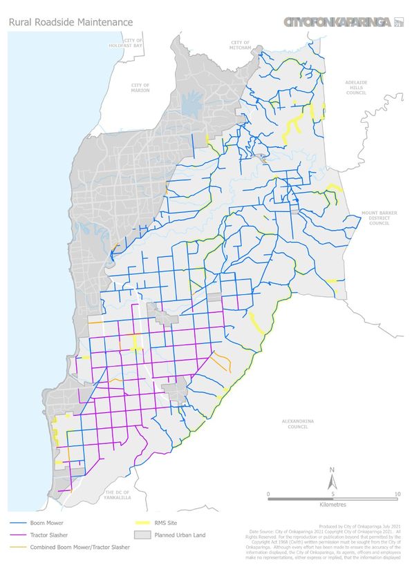
5.5      Risk Treatment......................................................................................................................17
                       5.5.1         Council Preparedness ...................................................................................................18
                       5.5.2         Private Property Preparedness .....................................................................................22
                       5.5.3         Asset Protection Zones .................................................................................................23
                       5.5.4         Bushfire Buffer Zones ...................................................................................................23
                       5.5.5         Community Engagement ..............................................................................................23
                       5.5.6         Prescribed Burning........................................................................................................23
                       5.5.7         Planning and Development Policy and Standards ........................................................24
                       5.5.8         Staff Work Health Safety considerations ......................................................................24
                       5.5.9         Operation NOMAD........................................................................................................24
                6.     Outputs of the Plan ....................................................................................................................25
                7.     Document Control ......................................................................................................................25
                8.     Appendix .....................................................................................................................................27
                9.     Attachments................................................................................................................................27

                                                                                                                                                                     3

Document Set ID: 5296417
Version: 20, Version Date: 14/07/2021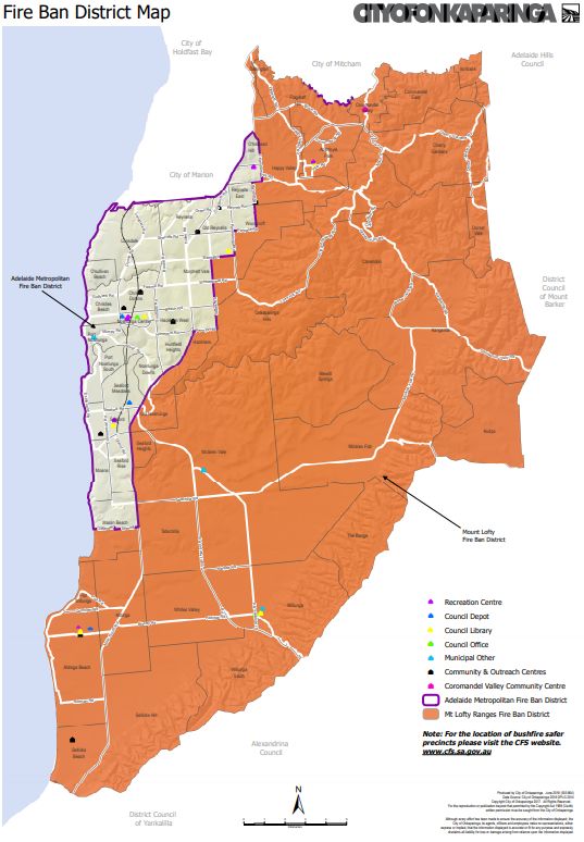
1. Introduction

                 Bushfire cannot be eliminated from the landscape, and there are circumstances when fire
                 cannot be controlled, however planning and preparedness activities can reduce the frequency,
                 spread and impact of bushfire events.

                 This plan adopts the Prevention, Preparedness, Response and Recovery (PPRR) Framework of
                 emergency management. Many of Council’s normal operations contribute to prevention and
                 preparedness, which are vital components in reducing the impact of bushfires on our
                 community.

                 Bushfire preparedness requires a partnership approach and is a shared responsibility between
                 government agencies, the private sector, non-government organisations, individuals and the
                 wider community. Every land owner has a responsibility to undertake bushfire prevention and
                 preparedness activities relevant to their location and situation.

                 This Plan is to be read in conjunction with the City of Onkaparinga Crisis Management
                 Arrangements, which is the overarching Emergency Management guidance for the
                 organisation.

                1.1       Objectives

                 The objectives of this plan are to:

                     a. Document bushfire risk in the City of Onkaparinga
                     b. Capture the current and future risk treatment strategies
                     c. Identify those asset or land custodians responsible for managing the risks and reducing
                        vulnerability to bushfire
                     d. Support and inform vegetation fuel reduction activities
                     e. Inform stakeholders of the potential bushfire risk within the City of Onkaparinga

                1.2        Considerations in developing the Bushfire Management Plan

                 The 2019/20 bushfire season was unprecedented, resulting in devastating fires across
                 Australia. This plan is produced partly in response to these fire events and to integrate the
                 recommendations of subsequent reviews at State and National level. It also outlines the
                 effective work that is undertaken every year by council to prepare land under its care and
                 control.

                 The following considerations have been applied in the development of the Bushfire
                 Management Plan (BMP):

                                                                                                             4

Document Set ID: 5296417
Version: 20, Version Date: 14/07/2021
a. Protection and preservation of life
                     b. Protection of critical infrastructure and community assets that support community
                        resilience
                     c. Protection of residential property as a place of primary residence
                     d. Protection of assets supporting livelihoods, economic production and community
                        financial sustainability
                     e. Protection of cultural, environmental and conservation assets
                     f. Compliance with relevant Acts, Regulations and Codes of Practice

                1.3        Relevant Legislation

                       Document                 Section                           Comment
                  Local                      s.7                   (d) to take measures to protect its
                  Government Act             Functions of          area from natural and other hazards
                  1999                       a Council             and to mitigate the effects of such
                                                                   hazards
                  Fire and                   s.105F                Owners of…land must take reasonable
                  Emergency                  Private Land          steps to:
                  Services Act               and s.105G            a) prevent or inhibit the outbreak of fire on
                  2005                       Council Land             the land; and
                                                                   b) prevent or inhibit the spread of fire
                                                                      through the land; and
                                                                   c) protect property on the land from fire;
                                                                      and
                                                                   d) minimise the threat to human life from
                                                                      a fire on the land
                  See also Appendix 1 for full list of Acts, Regulations and Codes of Practice which
                  influence bushfire management planning

                1.4        Fire Ban Districts and Fire Danger Season

                 The City of Onkaparinga is situated in both the Adelaide Metropolitan and Mount Lofty Ranges
                 Fire Ban Districts. See Figure 1 below for a map of both districts and Figure 2 for their extent
                 in the Onkaparinga council area.

                 Fire Danger Season (FDS) dates are set annually by the Country Fire Service (CFS) Chief Officer
                 based on recommendations from the Adelaide and Mount Lofty Ranges Bushfire Management
                 Committee. These dates are generally from the 1 December to the 30 April annually but may
                 vary according to climate and weather conditions approaching and during the summer months.

                                                                                                               5

Document Set ID: 5296417
Version: 20, Version Date: 14/07/2021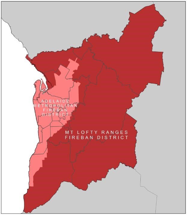
Figure 1. Adelaide Metropolitan and Mt Lofty Ranges Fire Ban Districts Map

                                                                                                         6

Document Set ID: 5296417
Version: 20, Version Date: 14/07/2021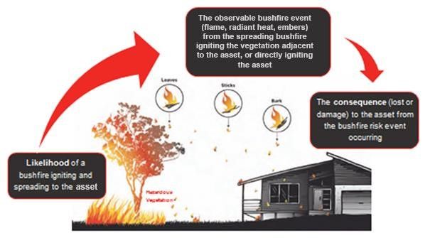
Figure 2. City of Onkaparinga Fire Ban Districts

                                                                                           7

Document Set ID: 5296417
Version: 20, Version Date: 14/07/2021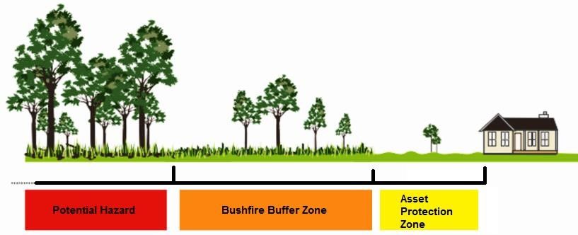
1.5        Overview

                 This plan addresses Prevention, Preparedness, Response and Recovery activities across three
                 land tenures, and describes our approach to bushfire management on each:

                     a. Council Land
                     b. Private Land
                     c. Crown/Other land (often owned by state government agencies)

                                        Figure 3. Overview of the Bushfire Management Plan

                                                                                                          8

Document Set ID: 5296417
Version: 20, Version Date: 14/07/2021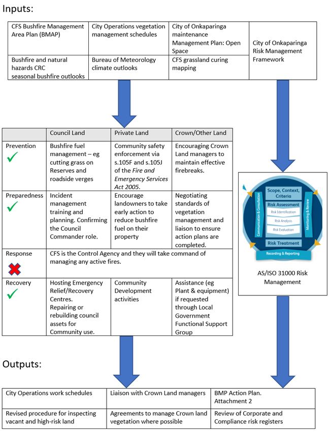
2. Inputs into the Plan

                2.1        Country Fire Service Bushfire Management Area Plan (BMAP)

                 The City of Onkaparinga is situated within the Adelaide and Mount Lofty Ranges Bushfire
                 Management Areas. This plan uses the CFS Bushfire Management Area Plan (BMAP) as a
                 primary input. The BMAP provides an assessment of bushfire risk in the council area and is an
                 evolving document which is managed by the Adelaide and Mount Lofty Ranges Bushfire
                 Management Committee. We use this BMAP to identify those areas of land that present the
                 highest risk and prioritise our prevention and preparedness activities in those areas.

                2.2        Climate and weather inputs

                2.2.1 The impacts of climate change
                 Climate change is likely to exacerbate the likelihood and consequence of bushfires and affect
                 those already especially vulnerable to this risk. Decreases in rainfall and higher evaporation
                 rates will mean less soil moisture and less run off in rivers, streams and reservoirs. Changes
                 in climate will have a range of impacts – for example on water resources, bushfire frequency
                 and intensity, primary production, infrastructure and the health of our landscapes. It is also
                 likely to increase the average number of high fire danger days experienced across the region
                 every summer. As well as the direct environmental impacts of climate change there is also the
                 interaction with other drivers of change such as population growth in these areas. Our demand
                 for water may also increase because of warmer temperatures and as our population grows.

                2.2.2 Wind and weather patterns
                 Weather conditions play a significant role in the likelihood of a bushfire occurring and its
                 behaviour and intensity should it occur. During summer a succession of high-pressure systems
                 track from west to east, usually five to seven days apart. The centres of these high-pressure
                 systems generally pass to the south of Adelaide. As these high-pressure systems move to the
                 east, wind direction turns north-east to northerly, often bringing a stream of dry and hot air
                 across the council area. The region experiences occasional thunderstorms and lightning in
                 spring and summer that may be dry or wet and cause gusty and variable winds.

                2.2.3 Australian seasonal bushfire outlook
                 Australian seasonal bushfire outlook and other hazard information from the Bushfire and
                 natural hazards Cooperative Research Centre and other sources will be made available to staff
                 and Elected Members via Weekly News and promoted through our public website for the
                 community to receive.

                2.2.4 Climate Outlooks
                 The Bureau of Meteorology climate outlooks are issued periodically and provide current
                 information and intelligence on a range of weather and climate forecasts.

                                                                                                             9

Document Set ID: 5296417
Version: 20, Version Date: 14/07/2021
3. Land tenure
3.1 Council Land
Bushfire preparedness on Council land is predominantly addressed through vegetation
management and bushfire fuel reduction on reserved, road verges and unmade road reserves.
The Maintenance Management Plan: Open Space guides the standard of vegetation
management applied to differing parcels of land under council’s ownership or care and control.
Council’s responsibilities exist in the prevention, preparedness and recovery phases, with
response activities during a bushfire being conducted by the CFS as the Control Agency.
3.2 Private Land
Council encourages landowners to take early action to reduce vegetation and bushfire fuel on
their properties, reducing the risk of bushfire to the community. Council enforces the general
duty of all landowners under the Fire and Emergency Services Act 2005 (FES Act) to prepare
their properties prior the fire danger season.
Section105F of the FES Act provides for council to issue hazard reduction notices to landowners
requiring them to reduce fine fuels and other hazardous vegetation within a 21-day timeframe.
An expiation for failing to comply with the requirements of the s.105F Notice can be applied if
the landowner does not reduce the identified hazard by the expiry date of the notice. The
State Government increased the value of the expiation fee amount in March 2021 from
$315.00 to $473.00.
S.105J of the FES Act entitles council to undertake works in default and clear fire hazards, with
the costs of such clearances being charged to the landowner as a debt against the property.
Council undertakes this action to reduce bushfire risk on private land if the owner fails to
comply with a s.105F hazard reduction notice by the expiry date.
3.3 Crown/Other Land
Council’s mitigation approach to Crown lands involves influencing landowners to prepare their
lands prior to fire danger season. We seek assurances from State Government Departments
that they have conducted risk assessments on land they own and have maintained vegetation
fuel loads to an appropriate standard, particularly reduced fuel zones (firebreaks) inside their
boundaries to prevent the spread of fire outside of their land. S.105 of the FES Act does not
enable council to issue hazard reduction notices to State Government departments so this
influencing work is done at the staff level throughout the year.
On occasion council does maintain Crown land under informal agreement by slashing
vegetation around City or township boundaries, partly for amenity effect and partly to reduce
fuel loads. Ongoing work is required to formalise agreements with these landowners and
progress cost recovery for our additional maintenance.
10
Document Set ID: 5296417
Version: 20, Version Date: 14/07/20214. Roles and responsibilities
4.1 Council
4.1.1 Fire Prevention Officers
Council is required by the FES Act to appoint at least one Fire Prevention Officer (as of 2021
there are two, within the Planning and Regulatory Services Division) who are responsible for:
a. assessing the extent of bushfire hazards within the relevant council area
b. assisting the council in providing advice and information to any bushfire management
committee
c. providing advice to owners of property in respect of bushfire prevention and
management
d. carrying out any other functions assigned to the fire prevention officer by the
regulations.
Prior to the fire danger season, council Fire Prevention Officers (FPOs) undertake an inspection
program of all vacant land in the council area and other high-risk properties, specifically those
properties that have been served a s.105F hazard reduction notice in the preceding two years.
The program involves:
a. Sending correspondence to owners of vacant and high-risk land in early October each
year. This proactively advises owners of the requirement to reduce vegetation and
bushfire fuel hazards on their property prior to the inspection program.
b. First inspections of properties are conducted throughout November, with those
properties who are not compliant with the requirements of the FES Act being issued a
s.105F hazard reduction Notice, specifying the actions required to be completed within
a 21-day timeframe.
c. Compliance inspections are conducted throughout the first two to three weeks of
December, with those properties still not compliant with the FES Act and the s.105F
Notice receiving an Expiation Notice (fine). Council-engaged contractors will also be
deployed to conduct works in default, with the costs of this work also charged to the
landowner. This work is done by council purely to reduce bushfire risk in the
community.
During the fire danger season, FPOs respond to customer requests about properties that may
present a fire hazard and can also issue Schedule 9 and 10 permits for hazardous activities if
required.
Outside of the fire danger season, FPOs administer the vegetation pile burning permit process.
This allows residents in specified areas to burn bushfire fuel safely, in accordance with the
Vegetation Pile Burning Code of Practice. Details of this process are available on council’s
11
Document Set ID: 5296417
Version: 20, Version Date: 14/07/2021website here: https://www.onkaparingacity.com/Payments-and-permits/Permits/Fire-
management-non-fire-danger-season
4.1.2 City Operations
The City Operations Division has responsibility for vegetation management and bushfire fuel
reduction on council land, specifically reserves and road verges. Staff undertake a scheduled
year-round program of vegetation management.
Specific bushfire prevention activities are timed to be complete by the start of the fire danger
season (anticipated to be 01 December annually) or when the fuel load has fully cured and
will not regrow after slashing. Examples of the programming and types of treatment
undertaken are provided at section 5.5.1 Council Preparedness.
4.2 Local Government Functional Support Group
The Local Government Functional Support Group (LGFSG) is a structure created from the
revised State Emergency Management Act 2004 and State Emergency Management Plan.
Managed through the Local Government Association, it provides a coordinating function for
Local Government entities throughout all phases of emergencies. Examples include the
coordination of plant and equipment to support Hazard Leaders or Control Agencies, provision
of water for aerial fire bombers or council staff to close roads or assess trees when requested
by the CFS.
Our responsibility is to have a clearly defined ‘Council Commander’ with delegations to act on
behalf of the council, including a financial delegation. The Council Commander is currently the
Director, City Operations or their delegate.
4.3 Community
Bushfire prevention and preparedness is a shared responsibility of State and Local
Government, Hazard Leaders and Control Agencies, landholders, and the broader community.
This Plan promotes the concept that all members of the City of Onkaparinga community are
responsible for the mitigation of bushfire risk and therefore need to understand and participate
in bushfire prevention and preparedness. Specifically, legislation (FES Act 2005) states that
owners of land must take reasonable steps to:
a. prevent or inhibit the outbreak of fire on the land; and
b. prevent or inhibit the spread of fire through the land; and
c. protect property on the land from fire; and
d. minimise the threat to human life from a fire on the land.
Information relevant to all members of the community on bushfire prevention and
preparedness can be found here: https://www.cfs.sa.gov.au/site/resources.jsp
Council, through Elected Members, will contribute to content for community newsletters to
promote appropriate bushfire fuel reduction and preparedness measures.
12
Document Set ID: 5296417
Version: 20, Version Date: 14/07/20214.4 State Bushfire Coordinating Committee
The FES Act 2005 Section 71A outlines the functions of the State Bushfire Coordination
Committee (SBCC). Some of these functions include:
a. promoting the State-wide coordination and integration of policies, practices and
strategies relating to bushfire management activities
b. providing guidance, direction and advice to bushfire management committees
c. preparing and reviewing the State Bushfire Management Plan and to ensure BMAPs
are consistent with the State Bushfire Management Plan.
4.5 Adelaide Mount Lofty Ranges Bushfire Management Committee
The SBCC has established the Adelaide and Mount Lofty Ranges Bushfire Management
Committee (AMLR BMC), and under the FES Act 2005, Section 73A (1) must prepare and
maintain a BMAP for its Bushfire Management Area (BMA). The Senior Emergency
Management Officer within Corporate Division is City of Onkaparinga’s representative on this
committee.
The key function of the AMLR BMC is to coordinate all relevant stakeholders with a
responsibility for bushfire management within the BMA, to undertake a risk assessment
process, and oversee the implementation of risk mitigation strategies. Its responsibilities
include:
a. Promoting the coordination of policies, practices and strategies relating to bushfire
management activities within its area.
b. Preparing and keeping under review a BMAP for its area and ensuring that the BMAP
is consistent with the State Bushfire Management Plan.
c. Initiating or preparing the development of plans, policies, practices or strategies to
promote effective bushfire management within its area.
d. Convening with local or regional forums to discuss issues associated with bushfire
management within its area, including working with local communities to promote and
improve effective bushfire management.
4.6 SA Housing Authority – Emergency Relief and Recovery Centres
Emergency relief is a functional service under the State Emergency Management Plan and SA
Housing Authority is the agency responsible for the activation and management of Emergency
Relief and Recovery Centres if they are required during and/or after a bushfire emergency.
If a bushfire reaches a threshold for activating an emergency relief or recovery centre(s), SA
Housing’s responsibilities include:
13
Document Set ID: 5296417
Version: 20, Version Date: 14/07/2021a. Establishing emergency relief centres to provide residents affected by bushfire with
short term shelter, information and personal support services such as food, temporary
accommodation, basic first aid and referral to interpreter services and pet care. Relief
centres are established during or in the immediate aftermath of the bushfire.
b. Establishing recovery centres as a one-stop centre for affected people to receive
financial assistance, gather information and seek referral to a wide range of recovery
services. Recovery centres take over from emergency relief and can be in place over
a much longer timeframe.
Council has pre-identified several sites that are suitable for hosting a relief and/or recovery
centre and has shared these details with SA Housing.
If the Emergency Relief Functional Support Group (ERFSG) have notified council that they will
not be opening an Emergency Relief Centre, or if they have not yet decided to open one,
Council’s Crisis Management Team will consider proactively opening one of our pre-identified
sites to support affected residents. This will be considered in conjunction with other
neighbouring councils and Non-Government Organisation service providers such as the
Australian Red Cross, to ensure a coordinated effort to support residents who may be affected
by a bushfire that will likely cross council boundaries. Such a venue could serve as a hub for
residents to access council services and information, be referred to other services and provide
a physical place to visit in the short term if their property is affected by the bushfire or if they
are prevented from returning home by the CFS, for example due to road closures. The venue
would not be able to support overnight accommodation or meals, as this is the role of the
ERFSG. If the need for emergency accommodation for residents was identified, then council
staff should escalate that to the LGFSG via our Crisis Management Team, Council Commander
(or delegate) or the Senior Emergency Management Officer.
To preserve public safety, it is important not to encourage residents to travel through any
dangerous areas while attempting to access an emergency relief centre, so the decision to
open such a site independently of the Emergency Relief Functional Support Group will need
consideration of the location and proximity of the bushfire and the likely direction of travel of
affected residents. We will also publicise the opening of any Emergency Relief Centre via social
media and/or media release as soon as practicable.
5. Risk Assessment
The City of Onkaparinga Risk Management Framework sets out the key principles that guide
how risk management is integrated at all levels of the organisation as well as providing the
processes and organisational arrangements for managing risk across the organisation.
Bushfire risk management in this plan utilises the Risk Management Framework and AS/ISO
31000 Risk Management Standard to effectively manage risk.
14
Document Set ID: 5296417
Version: 20, Version Date: 14/07/20215.1 Establishing the context
The 2019/20 bushfire season was unprecedented and there were devastating fires across
Australia. Bushfires burnt under conditions that exceeded the limits of firefighting capacity. In
South Australia, losses included Three lives, 196 homes, 68,000 livestock and approximately
$200 million in agricultural production.
The State Government’s Independent Review into South Australia’s 2019-20 bushfire season
and the Royal Commission into National Natural Disaster Arrangements both propose a range
of recommendations and where relevant, these have been considered in the preparation of
this Plan. The recommendations of the Royal Commission that are relevant to Local
Government have been summarised at Attachment 1 including the impact and risk to the
organisation, and our conformance with the recommendations through our existing programs
and services.
5.2 Risk Identification
Uncontrolled bushfire within the City of Onkaparinga or immediate surrounds is the primary
risk identified in this plan. Both people (residents and visitors) and assets are at risk. Staff
involved in bushfire management identify risk via several means, including using the CFS
BMAP, which identifies specific areas that have been assessed as having an Extreme, Very
High, High, Medium or Low risk rating. The BMAP further classifies assets as either human
settlement, economic, cultural heritage or environmental.
Residents are also able to report hazards to council which assists in hazard identification at
the property level. Commencing in 2020, residents were able to use a webform to report
specific properties they believe to be a fire hazard and council Fire Prevention Officers will
investigate.
This service is continuing to be available on council’s website here:
https://www.onkaparingacity.com/Services-and-projects/Reserves-trees-and-
verges/Reporting-a-fire-hazard
5.3 Risk Analysis
Risk analysis within the CFS BMAP is determined using several inputs, including:
a. Vulnerability of assets and people.
b. Vegetation type and its distance from the asset.
c. Predominant slope of the vegetation in relation to the asset.
d. Access and/or egress to and from the asset.
e. Frequency of ignitions in the general area of the asset.
15
Document Set ID: 5296417
Version: 20, Version Date: 14/07/2021Figure 4. Bushfire risk
5.3.1 Likelihood
In determining the likelihood of a bushfire igniting and spreading and impacting an asset the
following inputs are considered:
a. Australian Incident Reporting System (AIRS) data for known ignitions to gain an
understanding of fires that have occurred.
b. Current land use data to assist in determining vegetation layers and activities
associated with land use that could be potential ignition sources.
c. The ability for fire to establish and spread and the density/type of vegetation within
the landscape. Inputs include Bureau of Meteorology data relating to local weather
conditions, vegetation classification and fuel structures to undertake basic fire
behaviour modelling.
5.3.2 Consequence
The consequence of any bushfire event can be influenced by many factors. The susceptibility
of a built structure being adversely impacted by bushfire is dependent on the type of
construction and material used as well as its general condition. For example, concrete water
tanks or steel towers have a very low susceptibility, whereas a heritage timber barn would
have a very high susceptibility.
Bushfire Attack Level (BAL) is a measure of the radiant heat a building or structure is expected
to be subjected to in the event of a bushfire on a day of Extreme fire danger rating. This
measure is used by the AS3959 Australian Standard for the construction of buildings in
bushfire-prone areas. The BAL is determined by classifying the type of vegetation around the
building, the distance of the vegetation from the building, the slope of the land and the height
16
Document Set ID: 5296417
Version: 20, Version Date: 14/07/2021of the most exposed part of the building (typically the eaves). The higher the BAL, the higher
the radiant heat will be at that site during a bushfire.
Assets below a BAL of 12.5 Kw/m2 potentially reduce the ignition of the structure from radiant
heat. It should be noted that this Standard does not consider the potential impact of spark
and ember on structures.
Figure 5. Bushfire Attack Levels
5.4 Risk Evaluation
The risk of uncontrolled bushfire is evaluated at Attachment 1 Bushfire Management Plan -
Risk Assessment.
5.5 Risk Treatment
The risk of Bushfires cannot be eliminated; however, Council employs several controls to
reduce the likelihood or consequence of bushfire and to increase community resilience,
enhance the ability of firefighting agencies to access and suppress bushfires, limit the spread
of bushfire and protect people, assets and the environment.
17
Document Set ID: 5296417
Version: 20, Version Date: 14/07/20215.5.1 Council Preparedness
Council undertakes a range of fire prevention activities in the lead up to fire danger season
every year, to reduce flammable vegetation on our land.
Reserve and Rural Roadside Fuel Load Management Principles:
Roadside slashing and boom mowing are done to ensure vehicles parked on the side
of the road don’t ignite long grass contacting hot exhaust systems or vehicle
undercarriages.
Mowing and removal of roadside vegetation will not prevent deliberately lit fires.
Roadside native vegetation performs important ecological functions and is often
remnant biodiversity and tree canopy cover where adjacent farmlands have been
cleared for grazing. Wholescale clearance of this vegetation is not permitted under
Native Vegetation legislation.
Dead trees on rural roadsides provide hollows and habitat for a variety fauna. Provided
they are structurally sound these trees can remain in place for decades and could often
survive a fire event.
Rural Roadside Tractor Slasher Mowing:
Roadsides that are easily accessible and level are cut by a council tractor slasher. A total of
249km of roadsides are assigned to tractor slashing every year. Slashing starts in late Spring
once grasses have cured and takes approximately one month to complete.
Rural Roadside Boom Mowing
A total of 728km of rural roadsides every year are cut by boom mowing. A boom mower is
used in areas where the slope gradient is too high to use a tractor slasher or where there are
obstacles such as guard rails and trees. Boom mowing starts around September when grasses
cure and die during warmer drier conditions and continue until roadsides have been cut at
least once. Unseasonal late rains may cause a regrowth of areas already cut resulting in a
need to recut in subsequent rounds. One cut takes approximately 6-7 weeks to complete and
starts in the Southern parts of the council area where grass cures first and then progresses
Northwards up into the hills.
Roadside Marker Sites:
Roadside Marker Sites (RMS) consists of high value remnant native vegetation that holds
important biodiversity value. This maintenance is designed to treat weeds and apply selective
brush-cutting to reduce fuel loads. We manage 128 RMS sites with a total length of 111.35km
18
Document Set ID: 5296417
Version: 20, Version Date: 14/07/2021Figure 6. Rural Roadside Maintenance
19
Document Set ID: 5296417
Version: 20, Version Date: 14/07/2021Rural Roadside Pruning:
We contract tree canopy and shoulder clearance along selected roads throughout the McLaren
Vale, McLaren Flat and Willunga region so trucks and grape harvesting machinery can have
clear access during peak times around vintage. This is currently done on a three-yearly
programme. Remaining rural roadsides are contracted to a four-yearly pruning program that
ensures canopy and shoulder clearance requirements are met along our rural roads. These
requirements are based on Department of Infrastructure and Transport guidelines for road
clearance envelopes. While this pruning work is not critical for fuel load management it
supports safe access for CFS assets during a fire event while also ensuring that compromised
trees are removed before a fire causes them to fall onto escape routes.
Reserve mowing and fuel load reduction works
Our urban grassland and woodland reserves are mowed/ brush-cut for fire hazard reduction
in accordance with the CFS Bushfire Management Area Plan (BMAP). Where the terrain
permits, fence lines are sprayed, bush-cut and vegetation are cleared to create a 20-meter
buffer from key assets and human settlements. Mowing and brush-cutting are programmed
from September onwards when grasses and vegetation dries out.
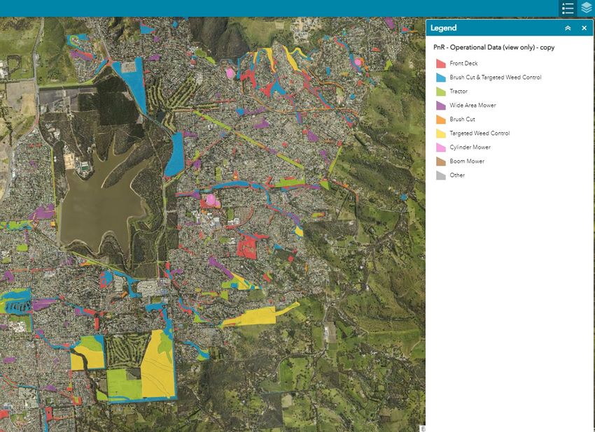
The two figures below show the BMAP extreme and very high-risk areas for a portion of the
council area, with our fuel reduction activities overlaid, showing that we do different types of
fuel reduction (tractor slashing, boom mowing, brush cutting etc) depending on access and
depending on the assessed risk of the area. 20-metre asset protection zones around dwellings
which are also in the extreme or very high-risk areas are specifically targeted, demonstrating
the use of the BMAP to guide our risk-based fuel reduction works.
20
Document Set ID: 5296417
Version: 20, Version Date: 14/07/2021Figure 7. Excerpt from GIS layer showing extreme and very high-risk areas
Figure 8. Excerpt from GIS overlaying different fuel reduction treatments
21
Document Set ID: 5296417
Version: 20, Version Date: 14/07/2021Attachment 2 Bushfire Management Plan - Action Plan lists risk treatments that are proposed
after the risk assessment process.
5.5.2 Private Property Preparedness
Private property preparedness relates to action taken by landholders to reduce the risk of
bushfire impacting on a house or other building. The primary focus of property preparedness
should be the reduction of fuel hazards around the property and the elimination of ignition
sources in areas surrounding or on structures, by:
a. reducing or removing hazardous vegetation and fine fuels (long dead grass, dried
leaves etc.)
b. removing other flammable materials and liquids
c. reducing the risk of impact from windblown spark and embers, flame contact and
intense heat radiated from bushfires.
If the occupants plan to stay and defend their home during a bushfire, having a well-prepared
property is essential. Information and fact sheets on property preparedness are available here:
http://www.cfs.sa.gov.au/site/resources/fact_sheets.jsp
Figure 9. Property preparedness zones
The clearance of native vegetation on private land is governed by the Native Vegetation Act
1991 and Regulations 2017. The Department for Environment and Water has information,
factsheets and an explanation of any clearance approvals that may be required on their
website here: https://www.environment.sa.gov.au/topics/native-vegetation/clearing. Specific
topics include native vegetation clearance relating to fences, tracks, burnt trees and fuel
breaks. The Native Vegetation Council and SA CFS also publish a guide called ‘Managing Native
Vegetation – How to reduce the impact of bushfire and the steps you need to take’, available
from the same website.
22
Document Set ID: 5296417
Version: 20, Version Date: 14/07/20215.5.3 Asset Protection Zones
An Asset Protection Zone (APZ) is a reduced fuel area surrounding a built asset or structure,
which is managed to minimize fuel loads, inhibit fire travel and reduce the effects of radiant
heat, flame, ember and smoke attack on the asset. Radiant heat is the most common cause
of death during bushfires and affects people (health and decision making), animals and
structures, whilst ember attack on properties is the leading cause of building loss during a
bushfire.
Introducing an APZ will provide separation between a bushfire hazard and the asset,
minimising direct flame contact and reducing the effects of radiant heat. They may apply to a
group of similar properties or along a boundary where the hazard exists. They may also be
used within the boundary of a property to inhibit fire spreading onto the property. The required
separation distance between vegetation and asset for an APZ is specified in the SBCC APZ
Standard, based on Australian Standard AS 3959 for building in bushfire prone areas. The
distance required between the asset and the vegetation is to reduce the Bushfire Attack Level
below 12.5 KW/m2.
Property owners can generally reduce, modify or remove native vegetation within 20m of a
building (including overhanging limbs). Significant trees may be protected under the
Development Act 1993.
5.5.4 Bushfire Buffer Zones
A Bushfire Buffer Zone (BBZ) is a reduced fuel area that aims to provide a buffer to reduce
the spread, intensity, ember attack and potential spotting from a bushfire. The works
associated with the establishment of a BBZ are focussed on selectively reducing the amount
of fine fuel vegetation, predominantly grasses and understory. These zones minimise
continuous fuel structures between surface and canopy fuels.
5.5.5 Community Engagement
Community education and engagement activities can extend from simple information provision
to extended training programmes. These activities are undertaken by many different groups
including CFS, MFS, SAPOL and the Australian Red Cross. The type of programme or
information that can be provided is dependent on the audience and their level or risk.
Community engagement programmes have the potential to achieve positive outcomes at both
the individual resident and community levels.
5.5.6 Prescribed Burning
Prescribed burning is the controlled application of fire under specified environmental
conditions to a predetermined area and at the time, intensity and rate of spread required to
attain planned resource management objectives. Prescribed burning by expert personnel from
the Department of Environment and Water was carried out in 2020/21 and further work is
being considered.
23
Document Set ID: 5296417
Version: 20, Version Date: 14/07/20215.5.7 Planning and Development Policy and Standards
A key objective of planning and development policy is to consider protection from bushfire to
ensure the safeguarding of human life and preventing the loss of assets including
infrastructure, cultural heritage and ecological assets. Current planning policies relating to
bushfire risk, contained in relevant Development Plans, may be reviewed as part of future
Development Plan amendments.
5.5.8 Staff Work Health Safety considerations
Actual bushfires or conditions where fire danger indices are Severe, Extreme or Catastrophic
present specific risks to staff working outside of council buildings or facilities. Staff working
outside or travelling between work sites are required to comply with internal Work Health
Safety (WHS) controls which are established for their safety. Such controls include WHS
policies and procedures which direct what type of activities can be performed during declared
emergencies or on fire danger days. Individual dynamic risk assessments must be completed
by each staff member in conjunction with a Supervisor before commencing duties on a day of
Severe or above fire danger, with additional considerations for any activities on a Catastrophic
fire danger day, with approval required by an experienced senior leader.
Relevant staff receive SMS notification the evening prior of total fire bans or fire danger days
of Severe or above, to allow early planning for modified service provision. Examples of services
that may be affected on fire danger days include:
a. Waste collections will start at 5.30am or earlier to keep drivers out of the hottest times
of the day.
b. Limits on use of power tools and equipment such as mowers during total fire bans. We
comply with CFS advice via this Factsheet.
c. Activities involving driving vehicles off-road are restricted to prevent ignition of long
grass by hot engine parts.
d. Postponement of works in the direct sun when the ambient temperature reaches 38°C.
Staff can undertake alternative duties or work at an appropriate indoor site.
5.5.9 Operation NOMAD
The potential and actual harm caused to the community from arson igniting bushfires
continues to be an important area of focus for South Australian Police (SAPOL). Operation
Nomad is a crime prevention programme using targeted SAPOL activities to reduce the
incidence and severity of fires in South Australia caused by deliberate, reckless or careless
human behaviour. The focus of the SAPOL operation is guided by the multi-agency Fire
Prevention Strategic Alliance.
24
Document Set ID: 5296417
Version: 20, Version Date: 14/07/20216. Outputs of the Plan
a. Attachment 1. Bushfire Management Plan - Risk Assessment. This is completed with
consideration for how it may influence or be included in Corporate or Operational risk
registers.
b. Attachment 2. Bushfire Management Action Plan. This describes current and future
bushfire preparedness activities and their progress to completion.
c. Other outputs of the plan include ongoing work to communicate with owners of private
land and Crown land prior to and during the fire danger season.
7. Document Control
Author (to whom changes are to be recommended):
Position Name
Senior Emergency Management Officer Neal McDonald
Stakeholders (audience – engagement groups):
Elected Members
Director Group
Internal staff: Fire prevention officers, Parks and natural resources, Spatial information
services.
External agencies: Country Fire Service, Metropolitan Fire Service, Department for
Environment and Water, Local Government Functional Support Group.
Reviewed by:
Position Date reviewed
Strategic Directions Committee 6 October 2020
Approved by (document owner):
Approval
Position / Group Name Approval date
DSID number
Chief Executive Officer Scott Ashby 10 November 2020 5329847
Current version:
Current version number Release date Review cycle
Review every 2 year/s from the
Version 2.0
Approval date
25
Document Set ID: 5296417
Version: 20, Version Date: 14/07/2021Risk calculation:
Consequence rating- Major
Likelihood rating- Possible
Overall risk rating- High
History:
Date Author Version Nature of change
30/10/2020 Neal McDonald V 1.0 Initial version
Inclusion of update from Cherry
Gardens bushfire in January 2021
and update per Notice of Motion at
7/07/2021 Neal McDonald V 2.0 SDC meeting of 6 April 2021.
Updated links after transition to ECM
Cloud.
Related documents:
(internal documents that need to be reviewed when this document is amended)
Document
Title of document
number
Crisis Management Arrangements DSID 3291265
WHS-GUI-0011 - Response to Declared Fire Danger Days V1.0 DSID 4458454
Document location:
Original in Ci
Published location
Anywhere
Ci Anywhere DSID 5296417
26
Document Set ID: 5296417
Version: 20, Version Date: 14/07/20218. Appendix
Appendix 1: Acts, Regulations and Codes influencing bushfire management
planning:
Local Government Act 1999 Section 7
Fire and Emergency Services Act 2005 Section 105
Native Vegetation Act 1991 (SA) Section 29
Native Vegetation Regulations 2017 (SA)
Environment Protection and Biodiversity Conservation Act 1999 (Commonwealth) Section 18
and 269
National Parks and Wildlife Act 1972 (SA)
Wilderness Protection Act 1992 (SA)
Crown Land Management Act 2009 (SA)
Country Fire Service vegetation pile burning Code of Practice
9. Attachments
Attachment 1. Royal Commission into National Natural Disaster Arrangements –
Recommendations relating to Local Government DSID 5491361
Attachment 2. Risk Assessment - Bushfire in the City of Onkaparinga DSID 5321635
Attachment 3. Action Plan – Bushfire Preparedness for fire danger season DSID 5321647
27
Document Set ID: 5296417
Version: 20, Version Date: 14/07/2021You can also read