CMEMS satellite near- real-time wave products - ESA Climate ...
←
→
Page content transcription
If your browser does not render page correctly, please read the page content below
CMEMS satellite near-
real-time wave products
Re ce nt upg r ade s and f utur e
deve lo pme nts to wards de laye d -
time pro ducts                                              E . C har le s, R . H usso n, A. Ollivie r,
                                                            A. Philip, G . G o imard (C L S)
                                                            A. Mo uche (IFR E ME R)
CCI Sea State User Consultation Meeting –23-25 March 2021
                                                            H . Wang (NOTC )
Outline

1. S t a tus o f C M E MS WAV E-TAC av ai lable p r o ducts a n d m i ssi ons

2. F o c us o n S A R s p e ctral w ave p r o duct s

3. F o c us o n L e ve l-4 g r i dded S W H p r o duct

4. Fu t u re d e vel opm ents
1 – Status of CMEMS WAVE-TAC
available products and missions
WAVE-TAC altimetry and SAR products
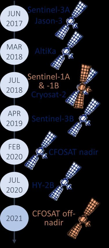
The WAVE-TAC now distributes 3 near-real-time products derived from the measurements of a
constellation composed of 9 satellites:
WAVE_GLO_WAV_L3_SWH_NRT_
OBSERVATIONS_014_001:
• Real-Time Level-3 waves from altimetry
• Edited, inter-calibrated, noise-filtered significant
wave height (SWH) and wind speed (U10)
WAVE_GLO_WAV_L3_SPC_NRT_
OBSERVATIONS_014_002:
• Real-Time Level-3 waves from SAR
• Spectral integral parameters (SWH, period,
direction, wavelength) + backward and forward
Wavelength propagation from the swell observation
WAVE_GLO_WAV_L4_SWH_NRT_
Significant wave height
OBSERVATIONS_014_003:
Pacific: SAR-derived swell conditions ; • Real-Time Level-4 waves from altimetry merging
Atlantic: Altimetry-derived along-track and all available measurements onto a 2°x2° grid in
gridded (contours) significant wave height daily files
CCI Sea State User Consultation Meeting –23-25 March 2021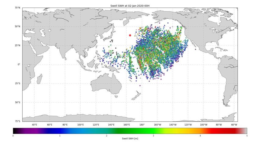
CMEMS Wave products result from the contribution of several agencies

        Sentinel-3A                       Sentinel-3A                     Sentinel-3A                                       L4 SWH
        Sentinel-3B                       Sentinel-3B                     Sentinel-3B                                   Sentinel-3A
                                                                                                                        Sentinel-3B
          Jason-3                                                            Jason-3
                                                                                                                          Jason-3
                                             CFOSAT                                                                    SARAL/AltiKa
        Sentinel-1A                                                       SARAL/AltiKa                                   CryoSAT-2
                                Available on www.aviso.altimetry.fr and    CryoSAT-2                                    HaiYang-2B
        Sentinel-1B             EUMETCAST (via eoportal.eumetsat.int)                                                     CFOSAT
                                                                           HaiYang-2B
       SARAL/AltiKa                                                          CFOSAT
                                                                                                                     Planned for 2021
                                        Internal product
                                                                                                                            L4 SPC
         CryoSAT-2
                                               Jason-3                     Sentinel-1A                                  Sentinel-1A
                                             Sentinel-1A
                                             Sentinel-1B
                                                                           Sentinel-1B                                  Sentinel-1B
        HaiYang-2B                          SARAL/AltiKa                        Available on https://marine.copernicus.eu

                                              CryoSAT-2
          CFOSAT                             HaiYang-2B

                                   R&D activities (new retrackings, CCI …)
CCI Sea State User Consultation Meeting –23-25 March 2021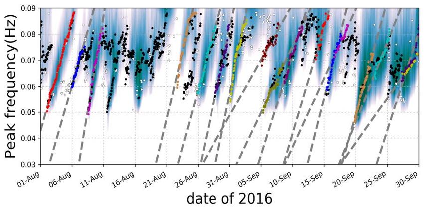
2 – Focus on SAR spectral wave product

CMEMS L3 SPC along-track product
•     Content:
       • Propagated partition Hs, peak Period (Tp) and direction (Dp)
       • Observation parameters: Hs, Tp, Dp from L2
          • + Quality flag derived from L3 analysis (overall consistency)
          • + Overall wave Spectra + partitions

•     Data Processing
       • Acquisition of swell products from Sentinel-1A/B L2 Wave Mode
       • Rejection of waves with short wavelength (wl < 200m) to keep those who best follow
          linear propagation theory & small Hs (< 30cm) → 60% swell partitions are used                     L3_SPC_NRT
       • Backward and forward propagation of partition integral parameters (Hs, Tp, Dp)

•     Documentation QUID (format, processing, validation): http://marine.copernicus.eu
•     Two available formats: swell observations gathered by swell fields & 3-hourly files
•     Daily updated, using all L2 data available at processing time
•     Distribution via ftp: ftp://nrt.cmems-du.eu/WAVE_GLO_WAV_L3_SPC_NRT_OBSERVATIONS_014_002

    MULTI-YEAR: Distribution of a full L3 reprocessing [May 2016-today] of S1A & B missions for mid-2021.

     CCI Sea State User Consultation Meeting –23-25 March 2021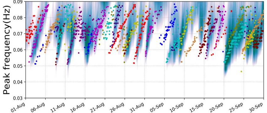
Validation of Level-3 spectral measurements                                                           L3_SPC_NRT

   ▪   Time series of wave measurements from L3 Waves product and in-situ
       buoys have been analyzed by comparing L3 Waves products propagated               Real Buoy Analysis
       at buoy location
   ▪   Buoy measurements are filtered, gathered by swell event and then
       associated with corresponding L3 wave product.
   ▪   Several events can be         identified, Extra-Tropical   Cyclones (ETC)
       and Tropical cyclones (TC).

Case Study over an ETC
Good match between S1,
  WW3 and the buoy for
 this extra-tropical storm                                                          Sentinel-1 Virtual Buoy Analysis

                                                                                   Timeseries of wave from buoys
                                                                                    and L3 SAR Wave products

  CCI Sea State User Consultation Meeting –23-25 March 2021                                               See Wang et al. 2019
Upcoming launch of Level-4 SPC product L4_SPC_NRT
Objective of this new product: merge multi-mission swell observations and provide the swell
evolution characteristics on a regular spatio-temporal grid.
It will be launched in CMEMS catalogue end of 2021
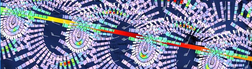
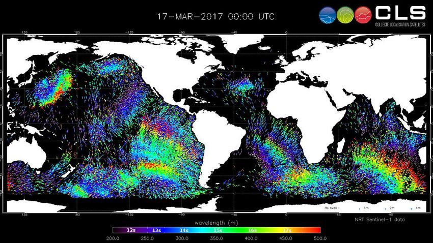
Level-3 Wavelength Level-3 SWH
Distribution of peak wavelength (top) and Hs (bottom) extracted from the Level-3 product based on Sentinel-1A and Sentinel-1B on
02/01/2020 - 00h. The Level-3 products are based on several Level-2 measurements. The swell field originates from a storm, whose
center is pin-pointed by a red circle.
CCI Sea State User Consultation Meeting –23-25 March 2021Upcoming launch of Level-4 SPC product L4_SPC_NRT
Objective of this new product: merge multi-mission swell observations and provide the swell
evolution characteristics on a regular spatio-temporal grid.
It will be launched in CMEMS catalogue end of 2021
Level-4 Wavelength Level-4 SWH
Distribution of peak wavelength (top) and Hs (bottom) extract from a Level-4 product derived from Sentinel-1 constellation on
02/01/2020 - 00h. The Level-4 product is based several S1-A and S1-B Level-3 products illustrated in the previous figure. The swell
field originates from a storm pin-pointed by a red circle.
CCI Sea State User Consultation Meeting –23-25 March 2021CFOSAT SWIM products for climate studies L3_SPC_NRT
Last week, CFOSAT Science Team Meeting concluded that the mission has entered its era of scientific exploitation. L2P 2D valid
Its relevance for CCI project is discussed in Daniele Hauser’s and Annabelle Ollivier’s talks after coffee break today. spectra
Since 2020, L2P and L3 SWH nadir products are provided in the CMEMS.
For climate purpose 2 types of products will be made available on Aviso web site
(https://www.aviso.altimetry.fr/en/missions/current-missions/cfosat/access-to-data.html):
- L2P nadir reprocessed and extended on a long time series (whole mission period)
- L2P off-nadir demo product including recent outputs and improvement from the Calval Team
(best spectrum and associated wave parameters, simple quality indicator, improved partitions,..)
And via CMEMS internal catalogue:
- L3 firework demonstration product derived from CFOSAT L2P off-nadir
CCI users are strongly advised to use these products tuned for application (climate) studies.
These added value products will be available during year 2021
L3 fireworks
Simultaneous nadir/off nadir (Sentinel1-like)
data, integrated every 70km
CCIODL/Ifremer
credit Sea State User Consultation Meeting –23-25 March 20213 – Focus on Level-4 gridded SWH product
CMEMS L4 SWH gridded product                                                                   L4_SWH_NRT

•   Content: Gridded Significant Wave Height [meters] @ 2°x2°:
     • Daily mean SWH and other statistics (std deviation, max, nb of obs)
     • Instantaneous estimate of SWH

•   Data processing:
     • Acquisition of available L3 NRT files                                                      Level-3 SWH
     • Selection of data over 2°x2° box
     • Weighted average of SWH measurements in each box, accounting for the time
        of measurement and local wave climatology
     • Dynamic land-sea-ice mask
     • Quality monitoring: Daily automated controls + Quality control reports

•   Documentation QUID (format, processing, validation): http://marine.copernicus.eu           Instantaneous SWH
•   Delivered in daily netcdf files
•   1st file is produced 1 day after map time, then updated 2 days and 5 days later.
•   Distribution via ftp: ftp://nrt.cmems-du.eu/WAVE_GLO_WAV_L4_SWH_NRT_OBSERVATIONS_014_003

    MULTI-YEAR: Distribution of a multi-year L4 SWH based on CCI L3 dataset + CFOSAT
    nadir reprocessing by mid-2021.

CCI Sea State User Consultation Meeting –23-25 March 2021                                       Daily mean SWH
CMEMS L4 SWH gridded product L4_SWH_NRT
Along-track Level-3 Daily fields Instantaneous fields
Sentinel-3A
Sentinel-3B
Jason-3
CFOSAT
CryoSAT-2
HaiYang-2B
SARAL/AltiKa VAVH_DAILY_MEAN: average of VAVH_INST: weighted average of level-3
available Level-3 along-track available along-track measurements to
measurements from 00 UTC until account for their temporal proximity and
23:59 UTC spatial interpolation when no measurements
Example of L3 measurements
over one grid cell (2°x2°) Time window = 24 hours Size of the time window varies according
to the local wave climatology
CCI Sea State User Consultation Meeting –23-25 March 2021Contribution of each mission to the L4 SWH product L4_SWH_NRT
• The gridded Level-4 SWH product is now merging SWH
derived from 7 different missions: Jason-3, Sentinel-3A,
Sentinel-3B, SARAL/AltiKa, CryoSAT-2, CFOSAT, and
HaiYang-2B
• This graph shows the percentage per mission of L3
SWH measurements used daily to build L4 SWH maps
over the January-June 2020 period
• The increased spatial and temporal density of
measurements allows a better mapping of the wave
heights (see table below)
VAVH_INST VAVH_DAILY_MEAN
Constellation used for
RMSD
the mapping N Bias (m) RMSD (m) SI (%) R N Bias (m) SI (%) R
(m)
5SAT (without S3) 30519 0.065 0.282 26.1 0.868 24584 0.070 0.183 20.4 0.909
7SAT (with S3) 30545 0.059 0.221 23.3 0.895 27897 0.066 0.156 18.9 0.922
Comparison of SWH maps with in-situ data at selected buoys during the 1-year period July 2019 – June 2020
CCI Sea State User Consultation Meeting –23-25 March 20214 – Future developments
Year 2021 and beyond                             WAVE-TAC roadmap: Main drivers and user needs

                                                        Robust and stable near-real-time L3/L4 wave products
                                                         with reliable intercalibration and in-situ calibration

                                                          Access to spectral wave parameters derived from
CFOSAT SWIM off-                                         Sentinel-1 SAR wide swath mode and CFOSAT/SWIM
  nadir spectral
   parameters       Multi-Year L3 SPC
                         product                         Increased sampling and accuracy of altimetry along-
                                                         track measurements to support regional and coastal
2021                                                                      wave modelling

             Multi-Year L3 SWH
           products derived from   NRT L4 gridded SPC   Access to wind speed collocated with waves (altimetry
               CCI+ dataset             product                               and SAR)
           → Multi-Year L4 SWH
                product                                  Improved description of uncertainties related to the
                                                                different instruments and datasets

                                                        Access to homogeneous long-term wave measurements
                                                                      for climate applications
Conclusions
Conclusions
  CMEMS NRT L3 SWH products
• A Near-Real Time constellation of 7 satellites, providing Significant Wave Height :
    Quality controlled / Inter-calibrated / Noise-Filtered / Monitored / With collocated wind speed

  CMEMS NRT L4 SWH products
• A Near-Real Time multi-mission gridded Significant Wave Height: daily statistics, estimate of instantaneous wave field

  CMEMS NRT L3 SPC products
• Reduced but more consistent set of swell observations compared to Level-2
• Offer the possibility to deploy virtual-buoy observer

  Upcoming launch of MULTI-YEAR products [mid-2021]
• Level-3 SWH reformatted from CCI Sea State dataset + CFOSAT nadir reprocessing
• Level-4 SWH (daily fields) computed from L3 CCI dataset
• Level-3 SPC reprocessed over the full period of S1-A and -B missions (since May 2016)

   Continuous collaboration between spatial agencies, CMEMS, R&D projects and users is essential to sustain a
performing satellite constellation for the monitoring of wave conditions and state-of-the-art data processing from Level 0
to Level 4

 CCI Sea State User Consultation Meeting –23-25 March 2021
Thank you
Data Access and Documentation,
visit: http://marine.copernicus.eu
Specific questions on SAR and altimeter
wave products, contact:
servicedesk.cmems@mercator-ocean.eu
Feedback on products, contact us:
echarles@groupcls.com
rhusson@groupcls.comLegend
WAVE-TAC 2018-2020 main evolutions
SPC SWH
2018 Launch of the WAVE-TAC
New Level-3 spectral product derived from S1-A/B
2019
Level-3 Lanczos noise-filtering
Better characterization New Level-4 gridded SWH product
of long swell measurements
Improved noise filtering based on EMD
2020
Addition of collocated wind speed Improved L4 mapping method
CCI Sea State User Consultation Meeting –23-25 March 2021Improvement for long swells L3_SPC_NRT
Quality improvement and increase of valid observations: specific processing for long wavelength since July-2019
• Long swell direction is not well resolved by Sentinel-1 Wave Mode, often indicating the opposite direction
• Considering both propagating directions, the most consistent wrt to smaller wavelengths is chosen
→ +100% more swell with wavelength > 600m are identified
Example of a S1 WV propagated mesurements belonging to a swell field event on 8th May 2018 off New
Zealand (strongest Hs ever recorded in South Hemisphere). S1 measured wavelength reaches 800 m!
CCI Sea State User Consultation Meeting –23-25 March 2021Evolution of the SWH mapping method L4_SWH_NRT
• Since December 2020 version, the temporal window used to select
observations projected in each grid cell varies spatially to account for
different wave conditions. It is smaller in regions where wave
conditions can change rapidly (e.g. storm affected areas) and larger in
regions where wave conditions are steadier (e.g. sheltered regions,
equator).
Spatial variability of the temporal window (in hours)
used to select observations. It accounts for the
temporal correlation and difference modelled at
each grid point in CMEMS WAVERYS dataset.
VAVH_INST
Mapping method
Performance of the Level 4 product with different mapping N Bias (m) RMSD (m) SI (%) R
methods. SWH maps are compared with in-situ data at Fixed temporal
30551 0.058 0.25 24 0.89
window (36h)
selected buoys during the period July 2019 – June 2020 Variable temporal
30545 0.059 0.22 23 0.90
window (You can also read