Col de la Crèche Château-Ville-Vieille - Chemins des parcs
←
→
Page content transcription
If your browser does not render page correctly, please read the page content below
PNR Queyras
In partnership with
OTI du Guillestrois et du Queyras
Col de la Crèche
Château-Ville-Vieille
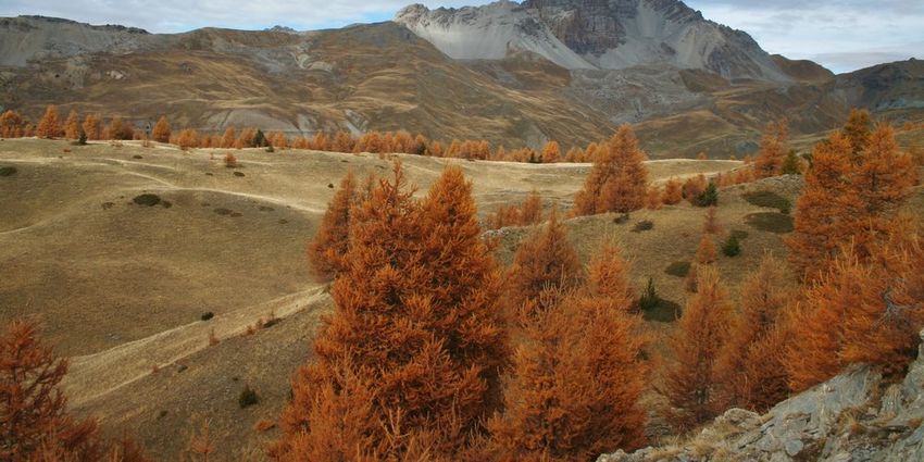
Le Pic de Rochebrune surplombe le vallon et le col de Péas (Benjamin Musella - PNR Queyras)
A view of the whole valley of Guil, for a Useful information
quick approach. Practice : WALKING
The climb takes place in a forest rich in colour and sounds. Duration : 4 h
Wrens, different chickadees, woodpeckers ... all sing their
melodies and cheer up the atmosphere. Once at the Length : 9.5 km
mountain pass, the view is fascinating. It covers 180° from Trek ascent : 628 m
Ratier to the Italian border. At the north, the great
Rochebrune guards the premises. The peak and its Difficulty : Medium
buttresses dominate the valley of Péas and enforce the
Type : Boucle
respect on this valley where herds have been roaming since
the dawn of time.
09/25/2021 • Col de la Crèche 1/8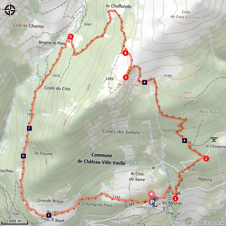
Trek

Departure : Les Meyriés
Arrival : Les Meyriés
Markings : PR GR®

Go to the end of the parking lot and follow the forest road to Rouet. Take the first track on the right (GR).
Continue on the GR to the point Le Puy.
1 - at the oratory, turn left on the path that goes into the woods. Reach a track, turn right and follow it to
the point "Platenq la Charpenelle" (1 900m).
2 - Turn left on a wide path that is rapidly shrinking and makes ascending switchbacks. Gradually emerge
from the forest and reach a short portion (10m) a little more technical in shale that lead to the Col de
Crèche.
3 - Turn right on a level, go around the great slump and turn left directly into the forest.
4 - Enter the pine forest and go down the switchbacks. Reach a wider path, turn right and quickly join the
sheep pen of Péas.
5 - Take the left path that reaches Rouet. The trail follows the forest track, except on a short passage from
a few metres down this track, and brings you back to the starting point.

                                            09/25/2021 • Col de la Crèche                                   2/8
On your path...
The Goldcrest (A) View when exiting the forest (B)
Hoodoo (C) The Dent du Ratier mountain (D)
Saint Charles Borromée Chapel (E)
09/25/2021 • Col de la Crèche 3/8All useful information
Altimetric profile
Min elevation 1684 m
Max elevation 2285 m
Transports Access
05 Voyageur: 04 92 502 505 Tourist Office of From château Queyras, take the D444 until
Queyras: 04 92 46 76 18 Meyriés. The car park is located in the village
centre on the left. In front ofthe country cottage
les Astragales)
Advised parking
Les Meyriés
Information desks
House of the Queyras Regional Nature Park
La ville, 05350 Arvieux
pnrq@pnr-queyras.fr
Tel : +33 (0)4 92 46 88 20
http://www.pnr-queyras.fr/
OTI du Guillestrois et du Queyras
Maison du Tourisme du Queyras, 05350 Château-Ville-Vieille
info@guillestroisqueyras.com
Tel : +33 (0)4 92 46 76 18
http://www.guillestroisqueyras.com
09/25/2021 • Col de la Crèche 4/8On your path...
The Goldcrest (A)
The Goldcrest is one of the smallest birds in Europe. It enjoys conifer forests.
Hyperactive, it passes from one branch to another, visits a bush, returns to a
tree, stays in one place by the speed its wings flap and leaves for foraging. It
eats larvae, insects and small spiders. Its presence is related to mild winters.
Indeed, the Goldcrest is fragile and a harsh winter would decimate a part of the
colony. Conversely, a mild winter would increase the number of individuals.
Attribution : Benjamin Musella - PNR Queyras
View when exiting the forest (B)
Just before the Col de la Crèche, the path comes out of the forest and offers
spectacular views of the Aigue Agnelle Valley. In the background, the snowy
peaks mark the border with the Ubaye on the right and with Italy on the left.
Attribution : Benjamin Musella - PNR Queyras
Hoodoo (C)
Fairy chimneys or hoodoos are formed of a column made of sandy and stony
brittle layers and a more solid rock that covers the column and ends up falling.
Here the cap has come off. So how are these hoodoos formed? Two opposing
theories (see mountain bike hiking, the Pierre Dimanche Canal for the second
theory). Some geologists believe the cap placed on the column prevents water
from coming up by capillary action. This phenomenon promotes the deposition
of minerals contained in the water and cements the sediments beneath the
protective rock. The columns are therefore already formed in the soil and
erosion will gradually discover them
Attribution : Benjamin Musella - PNR Queyras
The Dent du Ratier mountain (D)
The Dent du Ratier mountain overlooks the Arvieux valley to the east and the
gorges of the Guil to the south. This distinctive "stump" is a klippe: a piece of
rock stuck on different rocks. Indeed, the lower and wooded area consists of
shiny schists of Piedmont. As for the upper part, it consists of rocks from
Briançon composed of a majority of marble for sign engraving. The stump itself
is from limestone placed on a thin layer of schist. These last layers most likely
older than the others are the remains of old eroded layers.
Attribution : Benjamin Musella - PNR Queyras
09/25/2021 • Col de la Crèche 5/8Saint Charles Borromée Chapel (E)
Saint Charles Borromée was an italian bishop of the 16th century. He was
actively involved in the Catholic reform in struggling against abuses that had
developed within the church. In winter, the shepherds of Rouet practised
transhumance in Piedmont and Lombardy. That's where they got this saint not
very represented in France. The chapel was destroyed during the religious wars
in 1548 and rebuilt in 1687.
Attribution : Benjamin Musella - PNR Queyras
09/25/2021 • Col de la Crèche 6/8• En aucun cas les auteurs des contenus de ce site ne sauraient être tenus pour responsables de
problèmes ou d'accidents sur les itinéraires cités.
• Cependant, nous comptons sur vous pour signaler toutes contradictions importantes entre cette
fiche et le terrain.
• Pensez également à signaler les éventuels problèmes rencontrés pendant votre balade sur http://
sentinelles.sportsdenature.fr (erreur de balisage, panneau défectueux, pollution, conflit d'usages…).
• La vente de cette fiche est autorisée au coût d'impression.
• Ne pas jeter dans la nature.
L'outil Geotrek a été financé par l'Union européenne, le Parc national des Ecrins et le Parc national du
Mercantour.
Le projet Chemins des Parcs est financé par la Région Provence-Alpes-Côte-d'Azur et les Parcs naturels
régionaux des Alpilles, de Camargue, du Luberon, du Queyras et du Verdon.
Ce projet partenarial rassemble également le Comité Régional du Tourisme, les agences départementales
de développement touristique, les offices de tourisme et les syndicats d'initiative.
• The authors of this website will in no case be held responsible for problems or accidents on the
routes mentioned.
• We count on you to point out any inconsistency between this content and the field itineraries
• Please report any problems encountered on the routes (route marking problems, defective panels,
pollution, conflict of uses ...) on http://sentinelles.sportsdenature.fr
• The sale of this sheet is authorized at the cost of printing
• Please don’t litter
The Geotrek tool was funded by the European Union, the Ecrins National Park and the Mercantour
National Park.
The Chemins des Parcs project is funded by the Provence-Alpes-Côte-d'Azur Region and the regional
nature parks of Alpilles, Camargue, Luberon, Queyras and the Verdon.
This project was developed in partnership with the Regional Tourism Committee, the departmental tourist
development agencies, and tourist offices.
09/25/2021 • Col de la Crèche 7/8Avec le soutien de
09/25/2021 • Col de la Crèche 8/8You can also read