The Sirenians Trail Castellane - Chemins des parcs
←
→
Page content transcription
If your browser does not render page correctly, please read the page content below
PNR Verdon
                                                                                                       In partnership with
                                                                                                      OTI Verdon Tourisme

The Sirenians Trail
Castellane

Le mur des Siréniens (Christian Peuget)

And strange marine mammals called                                            Useful information
the sirenians inhabited our lands...                                         Practice : WALKING
40million years ago, the col des Lèques was under the sea.                   Duration : 1 h 30
In this warm sea lived peaceful marine mammals: sirenians
(ancestors of the current dugongs and manatees). In a                        Length : 3.7 km
unique place in the world, set up by the Haute Provence                      Trek ascent : 112 m
geological reserve, you will discover remains from 35million
years ago.                                                                   Difficulty : Very easy

                                                                             Type : Aller-retour

                                                                             Themes : A lookout, a viewpoint,
                                                                             Geology

                                          02/11/2021 • The Sirenians Trail                                            1/9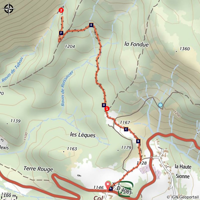
Trek

Departure : Col des Léques, Castellane
Arrival : Col des Léques, Castellane
Markings : PR

From the car park at the Col des Lèques, take the path along the campsite. In 500m, follow the path and
find a small pass and an intersection of marked trails.

1 - Go left and leave on the right the trail going up towards La Baume. Find a ruin by the relatively flat and
shaded path. Pass by and then find a small footbridge. After crossing it, climb the trail with a few wooden
steps under the pines. Cross the next valley and find a view of the Col des Lèques, the north face of
Cadières de Brandis and the summits of Robion and Destourbes, dominating Castellane. Go down the
path and go to the right in the direction of the valley where the sirenian fossil site is located.

2 - The same route is used for the return.

                                             02/11/2021 • The Sirenians Trail                               2/9
On your path...
The pass of Lèques (A) Roc de Castellane (B)
The valley of fossil mermaids (C) Ammonites (D)
The fossil valley (E) the Sirenia (F)
02/11/2021 • The Sirenians Trail 3/9All useful information
Advices
avoid the heat of summer, bring a hat, water, and walking shoes. The first part of the route passes
close to the pastures of the sheep in spring and autumn. The course may be slightly deviated in this
area to avoid crossing the herd. Follow the markup. Keep dogs on a leash.
Altimetric profile
Min elevation 1144 m
Max elevation 1211 m
Transports Access
« Limitons les déplacements en voiture, pensons 8km from Castellane, take the RN85 towards
aux transports en commun ! Prenez la ligne Digne-les-Bains until Col des Lques.
régionale BV1bis entre Riez et Castellane du 1er
Juillet au 11 octobre. Depuis Riez, départ 8h35,
retour 16h00. Depuis Castellane, départ à 7h30,
retour 16h20 et 19h30. Retrouvez tous les
horaires sur https://zou.maregionsud.fr/ ».
02/11/2021 • The Sirenians Trail 4/9Information desks
House of the Verdon Regional Nature Park
Domaine de Valx, 04360 Moustiers-Sainte-Marie
info@parcduverdon.fr
Tel : +33 (0)4 92 74 68 00
http://www.parcduverdon.fr/
OTI Verdon Tourisme
Rue nationale, 04120 Castellane
castellane@verdontourisme.com
Tel : +33 (0)4 92 83 61 14
http://www.verdontourisme.com
02/11/2021 • The Sirenians Trail 5/9On your path...
The pass of Lèques (A)
The "neighborhood" called Lèques situated to the north of pass of Lèques
evokes the name of these thrush traps, consisting of two flat stones, that
allowed to trap the birds at that time (a completely prohibited practice today).
A few juniper berries, thrushes’ favorite candy in winter, were placed between
the sticks. The bird had to move the sticks to peck at grains, and the vertical
stone fell and knocked it.
Attribution : DR
Roc de Castellane (B)
Overlooking the town from its 184m straight and steep cliffs, the top of the Roc
is decorated with a chapel topped by a statue of the Virgin and Child. Majestic,
strong and anchored since the dawn of time, it looks like the relic of a surrealist
dungeon, left there by improbable and fantastic creatures.
Attribution : DR
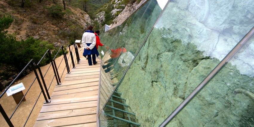
The valley of fossil mermaids (C)
Fossils less than 1% of living things are found fossilized, which goes to show
that fossilization is somewhat “miraculous”. It is the transformation of the
remains of an organism and its conservation in rocks. Obviously, the
mineralized portions (skeletons, shells, etc.) are best preserved. But wood and
fingerprints, traces of activities, could also be preserved, thus providing
valuable information.
Attribution : DR
Ammonites (D)
Fossils relate us about the history of life. They have allowed the birth of the
theory of evolution by showing us the existence of now extinct animals. In our
region, ammonites are a good example. They disappeared 65 million years ago
after having populated all the seas of the globe during the Mesozoic era.
Attribution : Stefano Blanc - PNR Verdon
02/11/2021 • The Sirenians Trail 6/9The fossil valley (E)
Water sometimes flows into the ravine. In its work of erosion, it gradually
reveals the relief shaped for the first time more than forty million years ago. On
the right bank, you can see a gray limestone massif dated back to 140 million
years (Jurassic). On the left bank of the marls and yellowish sandstone
limestone, dating back to 40 million years.
Attribution : DR
the Sirenia (F)
If sirenians the ravine of Tabori, who lived in the sea, are now at nearly 1,000
meters above sea level, it is not because of a sudden drop in the water level.
The sediment accumulated at the bottom of the sea for millions of years are
found upright and altitude when the Alps were raised.
Attribution : Guillaume Pluchon - PNR Verdon
02/11/2021 • The Sirenians Trail 7/9• En aucun cas les auteurs des contenus de ce site ne sauraient être tenus pour responsables de
problèmes ou d'accidents sur les itinéraires cités.
• Cependant, nous comptons sur vous pour signaler toutes contradictions importantes entre cette
fiche et le terrain.
• Pensez également à signaler les éventuels problèmes rencontrés pendant votre balade sur http://
sentinelles.sportsdenature.fr (erreur de balisage, panneau défectueux, pollution, conflit d'usages…).
• La vente de cette fiche est autorisée au coût d'impression.
• Ne pas jeter dans la nature.
L'outil Geotrek a été financé par l'Union européenne, le Parc national des Ecrins et le Parc national du
Mercantour.
Le projet Chemins des Parcs est financé par la Région Provence-Alpes-Côte-d'Azur et les Parcs naturels
régionaux des Alpilles, de Camargue, du Luberon, du Queyras et du Verdon.
Ce projet partenarial rassemble également le Comité Régional du Tourisme, les agences départementales
de développement touristique, les offices de tourisme et les syndicats d'initiative.
• The authors of this website will in no case be held responsible for problems or accidents on the
routes mentioned.
• We count on you to point out any inconsistency between this content and the field itineraries
• Please report any problems encountered on the routes (route marking problems, defective panels,
pollution, conflict of uses ...) on http://sentinelles.sportsdenature.fr
• The sale of this sheet is authorized at the cost of printing
• Please don’t litter
The Geotrek tool was funded by the European Union, the Ecrins National Park and the Mercantour
National Park.
The Chemins des Parcs project is funded by the Provence-Alpes-Côte-d'Azur Region and the regional
nature parks of Alpilles, Camargue, Luberon, Queyras and the Verdon.
This project was developed in partnership with the Regional Tourism Committee, the departmental tourist
development agencies, and tourist offices.
02/11/2021 • The Sirenians Trail 8/9Avec le soutien de
02/11/2021 • The Sirenians Trail 9/9You can also read