Canoe & Kayak Trail TUMUT RIVER - Tumut to Gundagai
←
→
Page content transcription
If your browser does not render page correctly, please read the page content below
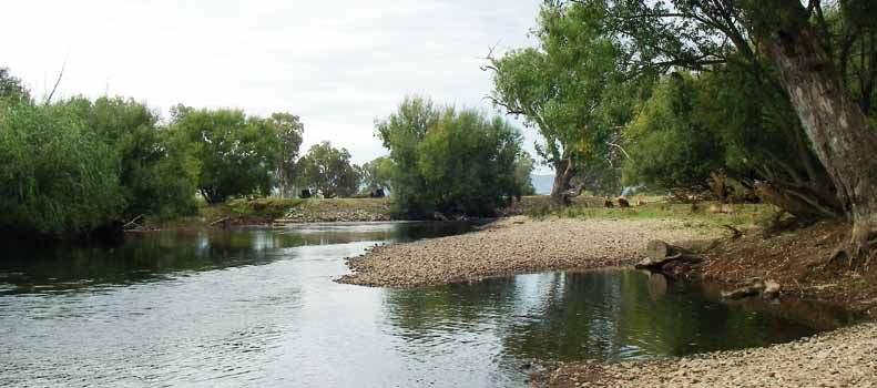
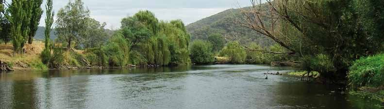
TUMUT RIVER
Canoe & Kayak Trail

     Tumut to Gundagai

                    www.lpma.nsw.gov.au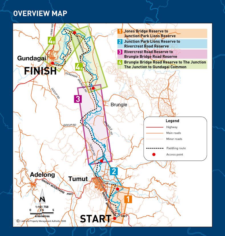
WELCOME
Welcome to the Tumut River Canoe and Kayak Trail.                           flow out of the Blowering Dam during summer months and the
                                                                            picturesque rural landscape in this area makes the Tumut River one of
This is a canoe or kayak trip down one of Australia’s inland rivers which
                                                                            the very best canoeing trips available.
enables you to enjoy the true beauty of our rural countryside and vast
river systems.
                                                                            Degree of difficulty
There are many Crown land reserves along the trail where you can
camp overnight, or stop for a well earned break.                            The Tumut River with normal summer flows is not a beginners’ river.
                                                                            The moving water is classified as Grade 1 rapid. The water is deep
                                                                            and cold. Canoeists should wear a helmet, avoid trees and fixed
The Tumut River
                                                                            objects that can trap your canoe and be aware of hypothermia if you
The Tumut River is a major tributary of the Murrumbidgee River,             capsize. Canoeing skills and some experience is needed to handle this
which, with the Murray and Darling Rivers, drains the huge Murray           moving water. Some sections are quite long and depending on flow
Darling basin.                                                              may take greater than five hours of paddling. A reasonable level of
                                                                            fitness is required.
The Tumut River rises in the Snowy Mountains where the Snowy
Mountain Hydro Electric Scheme captures and diverts much of the
annual snow melt from these mountains into tunnels and dams that
                                                                            Canoe & kayak maps and notes
feed the Tumut River. The huge Lake Blowering is the last of these          These canoe and kayak trail maps have been prepared by the NSW Land
dams and holds water for release down the Tumut River during                and Property Management Authority to help you plan your trip down
summer months for irrigation further down stream.                           the Tumut River. The distance to Gundagai by the river is some 95 kms.

The Tumut River Canoe and Kayak Trail starts underneath the                 Once at Gundagai you can continue your trip down stream using the
Blowering Dam wall, and follows the river to its junction with              Murrumbidgee Canoe Trail Maps.
the Murrumbidgee River just up stream of Gundagai. The regular              Access to the river is via Crown land reserves which are shown on
                                                                            the maps, together with a suggested route for support vehicles
                                                                            following canoeists.

                                                                                                                                                     Snowy Mountains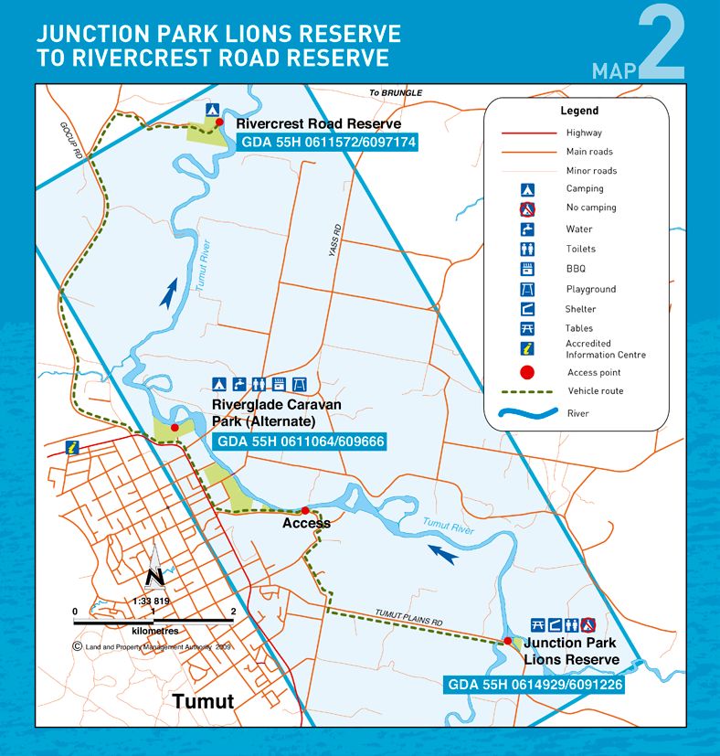
HOW TO GET THERE

The canoe and kayak trail starts at Jones Bridge Reserve, on the road
                                                                        Jones Bridge Reserve
                                                                        to Junction PARK LIONS RESERVE

                                                                        Destination
                                                                                                                                    1
to the Blowering Dam wall. The reserve is about 10 kms south of         Junction Park Lions Reserve
the town of Tumut. See the How to get there map for directions to
Tumut from NSW centres.                                                 GPS location
8 kms south of Tumut on the Snowy Mountains Highway turn right          GDA 55H 0614929/6091226
to the Blowering Dam wall. 1.5 kms from the intersection you will
pull off to the left next to the Tumut River and the site of the old    River distance
bridge. This is the launching site and start of the trail.              16.0 km

Starting GPS location                                                   Paddling time
GDA 55H 614249/6084843                                                  Approx 3 hrs

Camping                                                                 Camping
Camping is NOT permitted on this reserve.                               Not permitted
Canoe and kayak hire                                                    Facilities
Slide n Ride in Tumut – Phone 02 6947 6225.
                                                                        Toilets, tables, shelters
Email: slidenride@westnet.com.au

Facilities                                                              Vehicle access
There are currently no facilities.                                      Via Tumut Plains Road

Accommodation                                                           Accommodation
Accommodation is plentiful in Tumut with a full range of motels         Hotels and motels in Tumut (5 km)
and hotels. The Riverglade Caravan Park is one of the access points     Riverglade Caravan Park 02 6947 2528
to the river for canoeists and offers a full range of accommodation
(02) 6947 2528.                                                         Meals
                                                                        Tumut has a selection of cafes, restaurants and fast food
Meals                                                                   options (5 km)
Tumut has a selection of cafes, restaurants and fast food options.

Visitor information
The Tumut Visitor Information Centre is on the Snowy Mountains
Highway on the north side of Tumut (02) 6947 7025.

ABOUT GPS (Global Positioning System)
•	To help you locate the reserves along the river each reserve has
   GPS reference coordinates. The coordinates are based on the
   GDA datum. Your GPS should be set up to Position: UTM/UPS;
   Datum: GDA (or WGS); Units: Metric; North Reference: True.

•	The coordinates refer only to the zone you are in. You must                                                                      Tumut River
   state the zone if contacting emergency services. The Tumut River
   Canoe Trail is in zone 55H.
Junction Park Lions Reserve
to Rivercrest Road Reserve
Destination
2 Rivercrest Road Reserve
to Brungle Bridge reserve
Destination
3
Rivercrest Road Reserve (or alt. Riverglade Caravan Park) Crown reserve next to the Brungle Bridge
GPS location GPS location
GDA 55H 0611572/6097174 (or alt. GDA 55H 0611064/6093666) GDA 55H 609890/6112781
River distance River distance
12.5 km (alt. 6.5 km) 32.0 km
Paddling time Paddling time
Approx 6 hrs
Approx 2.2 hrs (alt. 1.3 hrs)
Camping Camping
Camping permitted
Camping is not permitted on this reserve without permission.
Please contact Rivercrest Retreat on 0419 466 902 prior to arrival
Facilities
(alt. all camping options)
No facilities (please take your rubbish with you)
Facilities Vehicle access
There are no facilities (please take your rubbish with you)
Via the Brungle Road 24 km from Tumut
Vehicle access Accommodation
Turn right off Gocup Rd 4.5 km out of town then right a
Nearest accommodation is at Gundagai 14 km away
further 700 m
Meals
Accommodation Nearest meals are at Gundagai 14 km away
Rivercrest Retreat 0419 466 907
Cafes, restaurants and fast food outlets
Riverglade Caravan Park 02 6947 2528
Motel and hotel options in Tumut (7 km)
Meals
Tumut has a selection of cafes, restaurants and fast food options (7 km)
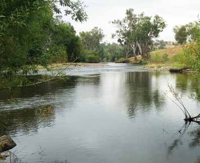
Tumut River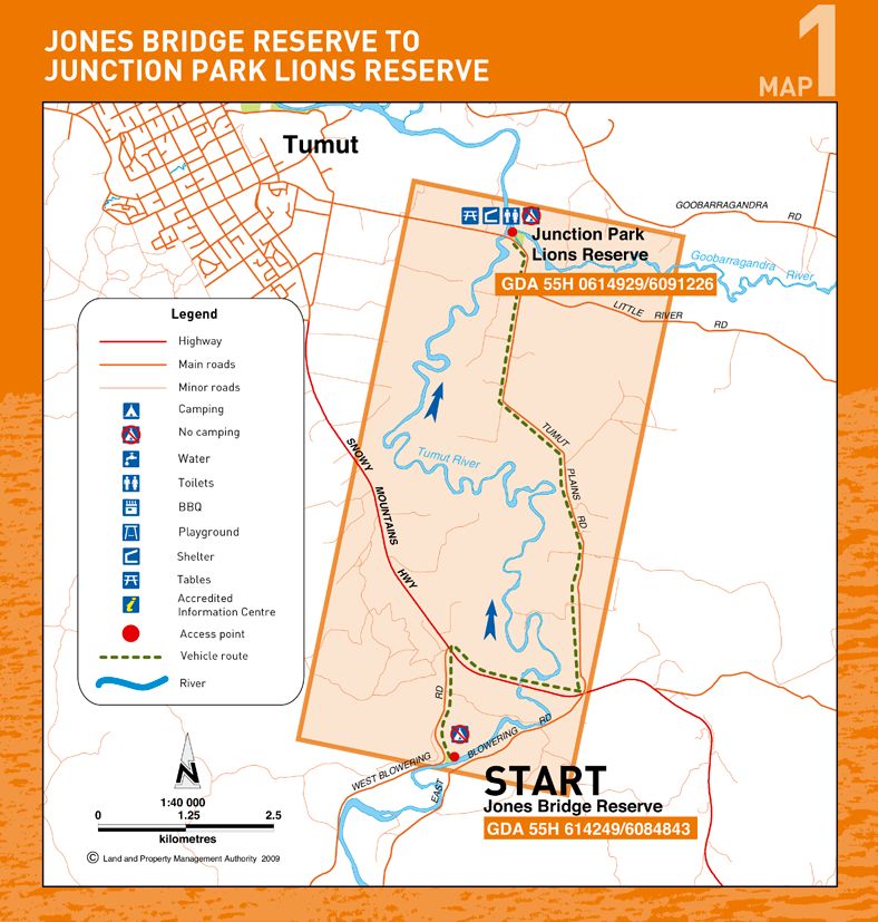
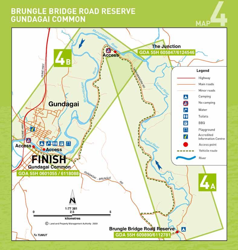
Brungle Bridge reserve
to The Junction
Destination
4 A
The Junction
To Gundagai Common
Destination
4 B
Road frontage to the river is available just downstream of the Gundagai Common, 20 m upstream of the old road bridge on the
junction with the Murrumbidgee River RHS or, just after the old rail bridge on the left hand side. The latter
GPS location has the best landing but is not as convenient to the caravan park
or town.
GDA 55H 605847/6124546
River distance GPS location
23.0 km GDA 55H 0601055/6118088
Paddling time River distance
Approx 4.5 hrs 18.0 km
Camping Paddling time
Not permitted, access point only Approx 3.5 hrs
Facilities Camping
No facilities Camping is not permitted on the common
Camp at the Riverside Caravan Park (02) 6944 1702
Vehicle access
Via Tarrabandra Road Facilities
Facilities are available at the Caravan Park or in Gundagai (2 km)
Accommodation
Nearest in Gundagai (14 km) Vehicle access
Via grassed river flats (dry weather only)
Meals
Nearest meals in Gundagai (14 km) Accommodation
Gundagai has a good range of hotels, motels and cabins
Meals
Wide range of options are available in Gundagai and along the
Hume Highway in South Gundagai
Visitor information
Gundagai Visitor Information Centre (02) 6944 1341
For Gundagai to Wagga Wagga, see Murrumbidgee River Canoe Trail
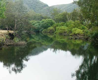
Tumut River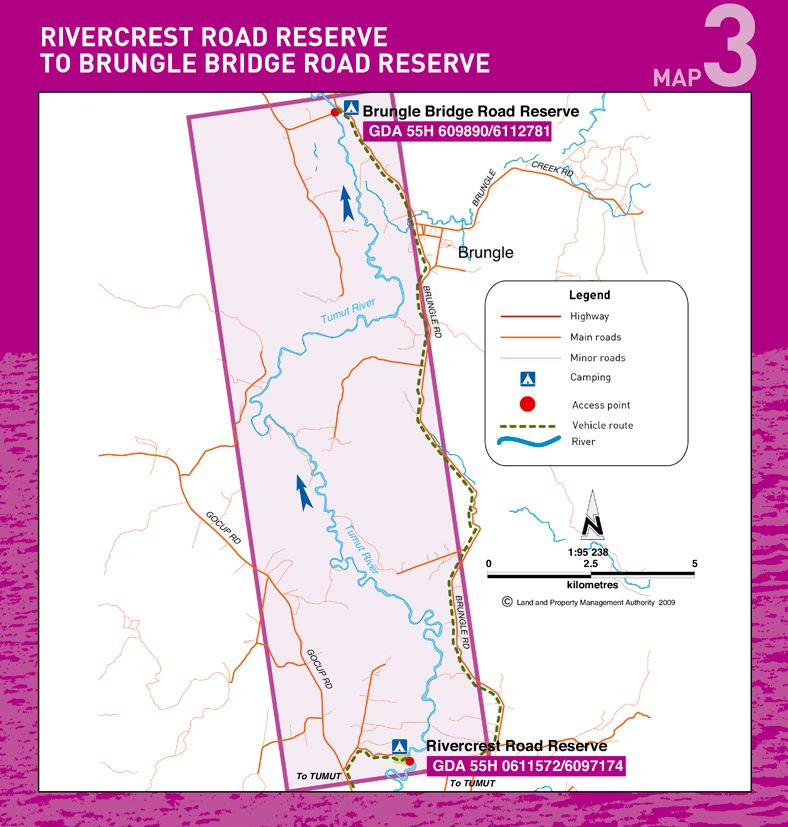
SAFE CANOEING CHECKLIST

Before you go                                                           Safety gear
 	Always check the river levels BEFORE your trip.                        	A high visibility Personal Floatation Device - Type 2 with a
   Daily river levels are available on                                      whistle attached should be worn at all times on the water
   www.waterinfo.nsw.gov.au
                                                                          	Hat and sunscreen
 	Always let someone know of your trip plans and ensure your
   support vehicle is aware of your intended rendezvous point             	Map, compass and GPS
   and how to get there
                                                                          	Spare paddle and repair kit
 	Canoeists/kayakers should be proficient in moving water.
                                                                          	Adequate drinking water and food for 5-8 hrs
   Beginners and children should become competent
   canoeists/kayakers on still water before attempting                    	A first-aid kit and basic knowledge of CPR
   moving water
                                                                          	Waterproof containers for food and warm/dry clothing
 	GPS coordinates have been supplied to help you locate
   the reserves. Set up your GPS for the GDA datum and                    	Appropriate footwear for water and rocks
   enter the coordinates of the reserves in advance                       	All canoes/kayaks should have fixed buoyancy with securing
 	Ensure you have enough fuel, food and water for the trip                loops at each end

On the river
                                                                          	A rope or throw line should be carried for rescue purposes

 	Make sure you have all your gear when you set off as the             At the campsite
  river’s flow may be too strong to paddle back upstream                  	Practice low impact camping – take out what you take in
 	Avoid travelling alone and stay in contact with other                 	Do not drink the river water without boiling or treating it.
  canoes/kayaks in your group                                               Carry adequate supplies of drinking water with you
 	Be alert for hazardous overhanging willows and snags                   	Light fires in fire places provided and extinguish completely
 	If you capsize, hold on to your canoe or kayak until you can           before leaving. Observe any fire bans that are in place
  beach safely. If the water is freezing leave your craft and             	Bury your waste at least 50 m from the river if there are
  head for the bank immediately                                             no toilets
 	If in doubt about a rapid or obstacle ahead pull into the bank       	Do not interfere with vegetation, gates, fences or stock
  and check on foot
                                                                          	Do not use soaps or detergents in the river
 	Mobile phone reception is not always reliable along
                                                                          	Respect other canoeists/kayakers and campers
  the canoe & kayak trails

 	To avoid overheating, paddle early in the morning or late
  evening with a break in the hottest part of the day                  Canoe & kayak trail is published by
                                                                       NSW Land and Property Management Authority
 	To fish in NSW waters, you must pay a fee and carry the
  receipt showing payment. For more information visit
                                                                      This booklet is designed as a reference guide only and is not to be
  www.dpi.nsw.gov.au
                                                                      used as a teaching aid. Canoeists/kayakers use the trail at their
                                                                      own risk.
Land and Property Management Authority
Head office
1 Prince Albert Road
Queens Square
SYDNEY NSW 2000
T 13000 LANDS
61 2 9228 6666
F 61 2 9233 4357
www.lpma.nsw.gov.au
For other great holiday ideas visit
www.lpma.nsw.gov.au
Tumut River
Images have been selected for marketing and communication purposes only and may or may not
be indicative of Crown land. Information is correct at time of printing.
© September 2009 NSW Land and Property Management Authority (B) P09/06/046You can also read