Subsurface sounding on Mars and the search for water ice: What are the techniques, what are we learning? - Caltech
←
→
Page content transcription
If your browser does not render page correctly, please read the page content below
SHARAD:
        The Shallow Radar on the
        Mars Reconnaissance Orbiter

                Subsurface sounding on Mars
                and the search for water ice:
                      What are the techniques,
                       what are we learning?
Than Putzig
Planetary Science Institute
SHARAD U.S./Deputy Team Leader

KISS Mars Subsurface Exploration - 2018 February 12   Image credit: NASA/JPL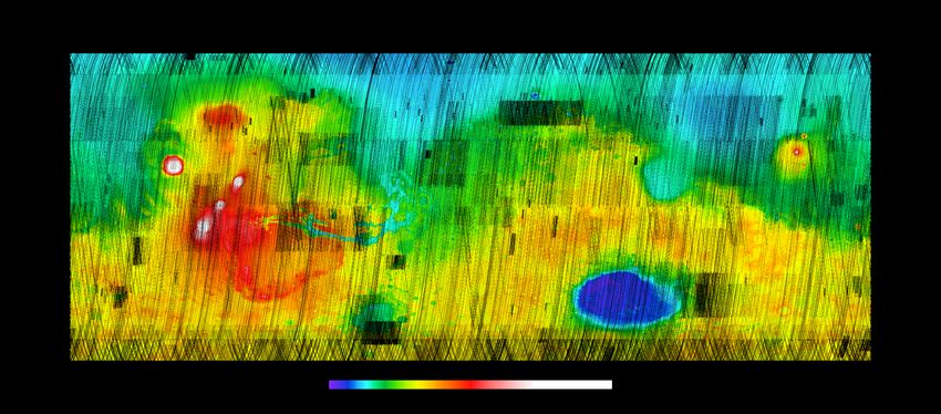
Orbital sounding radars at Mars
Mars                          SHARAD              instrument                MARSIS                    Mars
Reconnaissance                                                                                      Express
                                     255-320        orbit (km)              265-11550
Orbiter
                                           20 center freq. (MHz) 1.3-5.5
Objective:
Measure                                    10 bandwidth (MHz) 1                                Objective:
dielectric                             15 εr-½    range res. (m)            150 εr-½       Map water and
interfaces to a                                                                                    ice to
few 100-m depth                     0.3-1, 3-6   lateral res. (km)*         5-10, 10-30      5-km depth

                             io n
                    r e   ct
                  i
        b i t   d                                                       radargram (profiles)
     or                                            power

                                      range
                                                               delay time
                                    delay time
    ground track                     (∼ depth)

                                                                             distance along track
                                        individual echoes

    * Inline resolution is improved using synthetic aperture radar (SAR) processing techniques
CAT Scan

                                                  http://www.bz-berlin.de/galerie-archiv/bg-ct-loewe-scan

Computed Axial Tomography:
Combination of many X-ray images taken from different angles to produce
cross-sectional (tomographic) images (virtual "slices") of specific areas of a
scanned object, allowing the user to see inside the object without cutting.
                                                                   https://en.wikipedia.org/wiki/CT_scan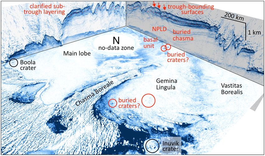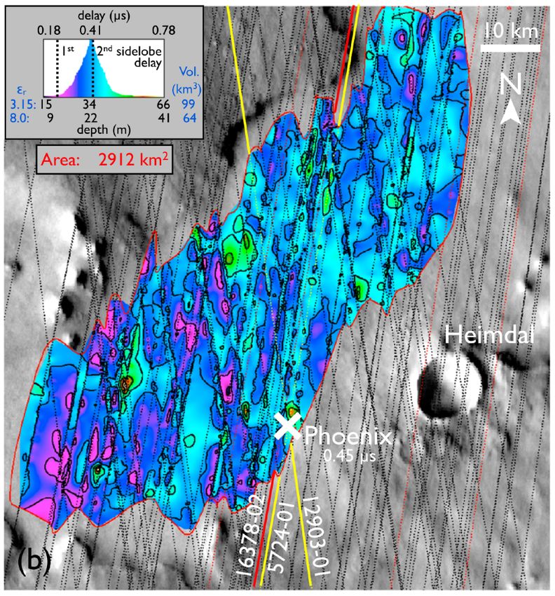
CAT Scan

                                   is
                               Ax

                                                  http://www.bz-berlin.de/galerie-archiv/bg-ct-loewe-scan

Computed Axial Tomography:
Combination of many X-ray images taken from different angles to produce
cross-sectional (tomographic) images (virtual "slices") of specific areas of a
scanned object, allowing the user to see inside the object without cutting.
                                                                   https://en.wikipedia.org/wiki/CT_scan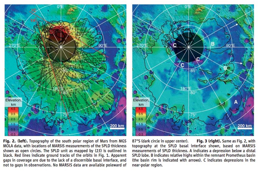
CAT Scan

                                                  http://www.bz-berlin.de/galerie-archiv/bg-ct-loewe-scan

Computed Axial Tomography:
Combination of many X-ray images taken from different angles to produce
cross-sectional (tomographic) images (virtual "slices") of specific areas of a
scanned object, allowing the user to see inside the object without cutting.
                                                                   https://en.wikipedia.org/wiki/CT_scan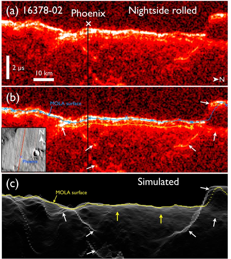
CAT Scan

                                                  http://www.bz-berlin.de/galerie-archiv/bg-ct-loewe-scan

Computed Axial Tomography:
Combination of many X-ray images taken from different angles to produce
cross-sectional (tomographic) images (virtual "slices") of specific areas of a
scanned object, allowing the user to see inside the object without cutting.
                                                                   https://en.wikipedia.org/wiki/CT_scan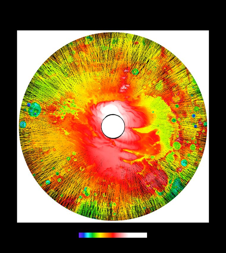
MRO SHARAD objective: Map subsurface rock, regolith, water, and ice.

Movie available at https://photojournal.jpl.nasa.gov/catalog/PIA10653                               Animation credit: NASA/JPL-Caltech/University of Rome/SwRI

     MRO altitude: 255 to 320 km                                        Wavelength: 15 m (~8-m vertical resolution in water ice)
     Transmitted sweep: 25 to 15 MHz Lateral resolution: 3 to 6 km (0.3 to 1 km inline with SAR)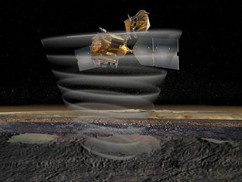
Current SHARAD Coverage   @ 3 km resolution

In MOLA elev.                                                                           Detections in
                       Korolev                                                            ice-rich
N: 88% S: 85%
                        crater                                                              and
                                                                  Dorsa
                                                                                          non-ice
                                                                 Argentea
                                                                                          terrains

                                N                                      S
                         Planum                                     Planum                     High
                         Boreum                                     Australe

                                            ±69°N
In black                 Phoenix
over MOLA             Arcadia
                                     Deuteronilus                           Utopia
elev: 31%       Amazonis                                                                       Low

                                                                              Elysium
                                    Valles
                                    Marineris
            Medusae
            Fossae
                                                                            E. Hellas

                                                         Malea
November 2005: A fortuitous discovery
during MARSIS commissioning phase:
Base of the icy layered deposits orbit 1855
North polar region elevation (MOLA)
Strong basal reflector indicates very little
path loss ( < 1 dB) ⇒ nearly pure, cold ice.
Also ⇒ low silicate content
ground
track
Picardi et al. (2005), Science 310, 1925The South Polar Region of Mars
Plaut et al. (Science 2007)
• A collecton of MARSIS radargrams were used to ‘strip off’ the layered deposits
MARSIS 2753
MOLA surface SPLD base
Planum
AustraleIn 2007, SHARAD began revealing
the internal structure of the NPLD
depth Observation 519201
permittivity
Phillips et al. (2008) of 3.15
assumed
below
surface
dunes
– Strong basal returns imply relatively pure ice (1/3 of NPLD
– Flat base ⇒ Mars’ lithosphere is > 300 km (2-4× Earth’s)In 2007, SHARAD began revealing
the internal structure of the NPLD
depth Observation 519201
permittivity
Phillips et al. (2008) of 3.15
assumed
below
surface
dunes
– Strong basal returns imply relatively pure ice (1/3 of NPLD
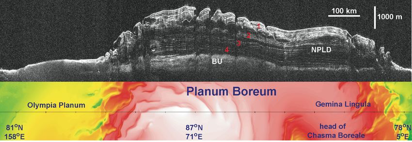
– Flat base ⇒ Mars’ lithosphere is > 300 km (2-4× Earth’s)In 2017, we assembled SHARAD data from
thousands of orbit passes to create 3D data volumes
Putzig et al., Icarus, in pressIn 2017, we assembled SHARAD data from
thousands of orbit passes to create 3D data volumes
Putzig et al., Icarus, in pressSHARAD detects possible base of ground ice in region of Phoenix landing site Putzig et al., JGR, 2014 Of all past landing sites, only Phoenix shows clear evidence of subsurface radar returns. We mapped what may be the base of ground ice at depths of ~15–66 m across 2900 km2 in the depression where the lander resides.
Why no detection of top of ground ice? Too shallow.
        Why possible base of ground ice?
   ⇒ Detections span surface sidelobe* zone.

                                                Phoenix

                                                          Putzig et al., JGR, 2014
 * Sidelobes are a product of processing the band-limited 15-25 MHz signals.
“Lobate Debris Aprons” Global
Morphology suggests water ice as a distribution
component, but amount was debated.
End members:
~ 10%: ice-lubricated debris flow Hellas
~ 95%: debris-covered glaciers
Hauber et al.
Eastern Hellas region (2008)
From CTX image P03_002294_1349_45S255W
Holt et al,
Science, 2008
30 km ~ 7 kmSHARAD results confirm the
debris-covered glacier hypothesis
Two examples
1. Eastern Hellas Holt et al, Science, 2008
Synthetic radargrams:
Critical Step: Modeling
of surface clutter (from
MOLA topography)
SHARAD data:
• Radar transparency.
• Little interior scattering.
• Losses similar to ice, PLD.
• Possible thin basal layers.
Depth-converted
SHARAD data:
Shows true geometry,
with MOLA surface in redDebris-covered glaciers Global
2. Deuteronilus distribution
Plaut et al., GRL, 2009
Delay time Deuteronilus
Mensae
Hauber et al.
(2008)
Depth (assuming H2O ice)
MOLA synthetic In all cases, the
buried upper
surface of the ice
is not detected.
SHARAD ground track This lack of
MOLA ground-track map detection
suggests the ice
may be shallower
than 10 or 20 m.Widespread Buried Ice in Arcadia Planitia
Bramson et al., GRL, 2015
• MRO cameras have imaged many terraced craters, formed by impacts
into layered surfaces. Dozens of these craters occur in Arcadia Planitia,
where SHARAD also detects a subsurface layer.
• HiRISE stereo images provide the depth to the Terraced Crater
terraces, typically ~ 40 m. Comparing the terrace
depths with their radar delay times, the layer
appears to be composed mostly of water ice.
• This ice sheet covers an area of ~106 km2
(California + Texas). It extends to 38°N latitude,
where conditions are more favorable for human
explorers than at the polar ice caps.
SHARAD profile
Interface correlated to terrace
Deeper unrelated interfaceWidespread Buried Ice in Utopia Planitia
Stuurman et al., GRL, 2016
SHARAD detections reveal roughly 14,000 cubic kilometers (~ 1.2 times the
volume of Lake Superior) of subsurface water ice in Utopia. Discovery confirms
the idea of a water-ice cause for geologic features observed in the area (mesas
capped by polygonal terrain), Adds to Mars’ global inventory of water ice and to
non-polar areas with resources potentially accessible during a human mission.MARSIS at Medusae Fossae Formation Mars:
Equatorial Ice or Dry, Low-Density Deposits?
Watters et al., Science, 2007
Radar times to an apparent basal return of the .
Medusae Fossae formation indicate a low
dielectric constant consistent with either water
ice or a low-density deposit such volcanic ash.
At the time, other data didn’t demonstrate a
clearly favorite of these interpretations.
Most people leaned toward the ash hypothesis.
But this is an unsettled debate…Breaking news…
Measuring Dielectric Losses in Potential Ice-Rich Terrain
Campbell and Morgan, GRL, in press
• Analyzed variations in SHARAD power
w/ frequency to measure loss tangent. Amazonis Elysium
• Higher loss points to sediment/rock,
lower loss may indicate water ice.
• Results show that:
– Amazonis and Elysium materials are
consistent with rock/dry sediments.
– Lobate debris aprons and lineated
valley fill are dominated by ice.
– Medusae Fossae materials are close
Deuteronilus LDAs Medusae Fossae
in loss to LDAs, consistent with a
large fraction of ice over full depth.
– Arcadia and Utopia mantling
materials have higher losses,
allowing for only thin veneers of
near-surface ice.
Arcadia UtopiaWhat have we learned?
• Radars have shed new light on the nature and
timing of the polar deposits and their
connection to the global climate of Mars.
• Strong basal returns show that mid-latitude
glaciers are ice-rich, under a veneer of debris
that is too thin for SHARAD to resolve.
• Weaker returns in other areas may represent
extensive deposits of ground ice, extending
into zones accessible to human missions.Current SHARAD Coverage @ 3 km resolution
In MOLA elev. Detections in
Korolev ice-rich
N: 88% S: 85%
crater and
Dorsa
non-ice
Argentea
terrains
N S
Planum Planum High
Boreum Australe
±69°N
In black Phoenix
over MOLA Arcadia
Deuteronilus Utopia
elev: 31% Amazonis Low
Elysium
Valles
Marineris
Medusae
Fossae
E. Hellas
MaleaCurrent SHARAD Coverage @ 3 km resolution
In MOLA elev. Detections in
Korolev ice-rich
N: 88% S: 85%
crater and
Dorsa
non-ice
Argentea
terrains
N S
Planum Planum High
Boreum Australe
±69°N
In black Phoenix
over MOLA Arcadia
Deuteronilus Utopia
elev: 31% Amazonis Low
Elysium
Valles
Marineris
Medusae
Fossae
E. Hellas
MaleaWhat do we need to learn?
• If we are really going to send people to Mars,
we need better means to locate accessible ice
and establish its depth and concentration.
• To do so over broad areas, we need a new
orbital radar sounder operating with a broad
bandwidth at higher frequencies.
• At landing sites, we need rovers equipped
with ground-penetrating radars — as well as
other tools, e.g., geophones and active seismic
sources — and a means to mine the water!Thank you!
You can also read