Hydrological Modelling and Analysis of Water Logging Areas for Panvel Region: An Innovative Approach - irjet
←
→
Page content transcription
If your browser does not render page correctly, please read the page content below
International Research Journal of Engineering and Technology (IRJET)                                          e-ISSN: 2395-0056
         Volume: 07 Issue: 06 | June 2020                   www.irjet.net                                             p-ISSN: 2395-0072

Hydrological Modelling and Analysis of Water Logging Areas for Panvel
                  Region: An Innovative Approach
      Mitushi D.1, Prajakta G.2, Jagruti B.3, Priyanka G.4, Harshal Pathak5, Gayatri Deshpande6
                           1-4Student,   Pillai HOC College of Engineering and Technology, Rasayani
                          5,6Professor, Pillai HOC College of Engineering and Technology, Rasayani
---------------------------------------------------------------------***----------------------------------------------------------------------
Abstract - Flood disasters in the last decade have confirmed             Urbanization results in elevated stormwater runoff, greater
that, the risk from flooding has increased significantly                 and more intense streamflow. Low Impact Development
worldwide. Flood is a natural disaster which is caused due to            (LID) are used to mitigate these effects of urban land use by
heavy rainfall, melting of snow area, increased water level in           retaining large volumes of stormwater runoff (water
natural bodies, etc. which causes negative impact on                     quantity). Best management practices are use for controlling
environment. Due to urbanization, catchment areas are                    runoff by using different LID techniques. such as rain water
formed which increases flood peak and volume in less time.               harvesting, inlet control, detention basin.
Flooding leads to loss of life, loss of economy, structural and
non structural losses. Panvel region is considered as the                2. NEED FOR STUDY
catchment area in this study. It is segregated into a number of                     Maximum Flood losses are caused due to the
land use pattern such as open area, road area, and grassy area           stormwater; It means when the rainfall takes place. Due to
which is modeled by using Storm Water Management                         heavy rainfall, runoff is increased on the ground surface this
Modelling (SWMM) software based on different land use in the             creates a problem like economic losses, tangible losses,
catchment. Various Best Management Practices (BMP) has                   intangible losses. To avoid this loss it is necessary to mitigate
been introduced to reduce runoff depth for water logging                 such runoff which causing a flood. By using traditional
areas in Panvel region. By treating this runoff water, small             methods floods should be mitigated but it can be found that
water requirement can be fulfilled and can be supplied to the            it is not applicable for the urban areas.In most cities in India,
villages, cities or industries.                                          the runoff from roads, buildings and other urban areas, is
                                                                         directed to conventional drains/ conveyance systems.
Key Words: Waterlogging Areas, Panvel, SWMM, DEM,                        During the rainy season, it can be found that these drainage
Google Earth, BMP; Rain barrels, Holding pond, Detention                 systems are exceeded hence that causes floods.This thesis
tank,.                                                                   aims to study flood problems in complex urban areas. A case
                                                                         study of a Kalundre river catchment in the region of Panvel
    1. INTRODUCTION                                                      has been chosen as it covered wider aspects and
                                                                         complexities related to urban flooding in the Indian
     Stormwater runoff can be defined as “the water that                 environment. The study targets to integrate the flood
flows over the land from rainfall during or after a storm                management aspects with innovative methods and their
event or as a result of snowmelt” The physical and chemical              application in the Indian scenario. In India from the last 10
characteristics of stormwater runoff change as urbanization              years the major problem of the flood is arising in Mumbai,
occurs .Over the years, the trend in India has been toward               Uttarakhand, Bihar.so it is necessary to find sustainable
increased urbanization Indian census 2001 figured 285                    solutions to mitigate the flood.
million people stay in 35 metro cities, and is estimated to
cross 600 million with 100 metro cities in 2021. The runoff              3. METHODOLOGY
from built up areas within cities is generally collected with
conventional drainage systems and finally discharged into a                       In this study we have taken rainfall event from 10th
water body. In most urban areas, conventional stormwater                 July 2019 to 10th August 2019 which has cross highest peak
management has led to increasing environmental and                       during that period. SWMM software is the hydrological
economical problems. The conventional system is designed                 modelling software which can calculate rainfall to runoff
for a particular rainfall and is inadequate to cater to higher           process.
rainfall intensities. Hence the conventional system fails and
cause flooding results in tangible and intangible losses. The                    Assessment of flood disclosure had been done by
term "stormwater best management practices" implies a                    combining existing methodologies and some innovative
comprehensive approach to the planning, design,                          techniques. This section provides introduction to the
implementation, and operation of stormwater drainage                     methods used in the study and the discussion on analysis of
improvements. The purpose of the best management                         non-structural and structural flood management measures.
approach is to develop effective drainage systems that                   This section briefly describes the methods SWMM uses to
balance the objectives of maximizing drainage efficiency

© 2020, IRJET        |    Impact Factor value: 7.529           |    ISO 9001:2008 Certified Journal            |   Page 1643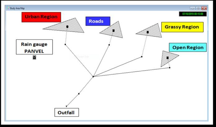
International Research Journal of Engineering and Technology (IRJET) e-ISSN: 2395-0056
Volume: 07 Issue: 06 | June 2020 www.irjet.net p-ISSN: 2395-0072
model storm water runoff quantity and quality through the 3.2 MODELING BY USING SWMM
following physical processes:
1. Start new project The sub-catchment, Kalundre river was modelled
2. Create Time series for the rainfall event from 10th July 2019 to 10th August 2019
3. Enter basin model data by using SWMM. From that water depth of the waterlogging
4. Create rain gauge for each area areas can be simulated. It was observed that the peak water
5. Apply time series for rain gage depth was 0.82m.
6. Create and execute a run simulation
7. View the result
Fig -2 Panvel region modeling using SWMM
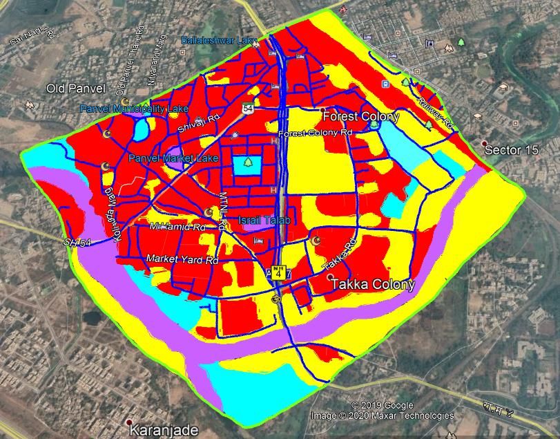
3.1 Land Use Pattern
Land use patterns are categories of development
activities or land surface characteristics assigned to each sub
catchment. Examples of land use activities in this case study
of Panvel area is segregated into a number of land use
patterns such as urban area, open area, road area and grassy
area which is useful to identify discharge from each land
uses.
Fig -3 Runoff Depth Modelling using SWMM
4. RESULTS AND DISCUSSION
The Kalundre river sub-catchment was modelled for
the rainfall event of 10th July 2019 to 10th August 2019 13th
July 2017 to 15th July 2017 by using SWMM. From that
runoff depth of the channel can be simulated. It requires
some of the major parameters like area of each basin,
Mannings roughness coefficient for the conduits, Slopes etc.
4.1 Implementation of LID by using SWMM
The main aim to prepare the land use is to calculate area of
each land use of a particular basin. With the help of the land
uses the implementation of the different LID’S techniques
can be done. SWMM tracks the quantity and quality of runoff
made within each sub catchment. It tracks the flow rate, flow
depth, and quality of water in each pipe and channel during a
simulation period made up of multiple time steps. SWMM 5
has recently been extended to model the hydrologic
Fig -1: Land use pattern
© 2020, IRJET | Impact Factor value: 7.529 | ISO 9001:2008 Certified Journal | Page 1644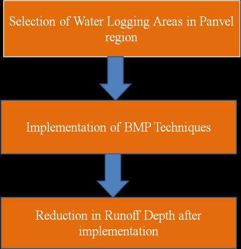
International Research Journal of Engineering and Technology (IRJET)                                      e-ISSN: 2395-0056
         Volume: 07 Issue: 06 | June 2020                www.irjet.net                                             p-ISSN: 2395-0072

performance of specific types of LID controls. The LID                        Table 3. Effect of detention tank on Rainfall intensity
controls that can be choose include the following green                                Sub-        Height of        Lagging
infrastructure practices:                                                           catchmen       Detention         Time
                                                                                        ts          tank(m)          (hrs)
Case 1: Implementation of Permeable Pavement System on                               Panvel
road area                                                                                               5              20
                                                                                     region

The Permeable pavement system is designed to reduce                     5. CONCLUSIONS
water logged road areas. Following table shows the effect of
permeable pavement system as a LID on water depths                             •   Water logging problems can be solved by using this
including total percentage reduction.                                              sustainable drainage solution system for Storm
                                                                                   water.
Table 1. Implementation of Permeable Pavement system                           •   By using this BMP techniques, runoff water can be
               as a LID on water depths                                            reuse for Industrial uses, Irrigation, AC Plants,
                                                                                   Gardening, Domestic purpose, Boiler plants and
                                Peak water                                         Construction purposes.
                   Peak
                                depth with                                     •   Rain barrels, Holding pond, Detention tank,
      Sub-        Water
                                Permeable            %                             Permeable pavement, Underground storage tank
   catchmen        depth
                                Pavement          Reduction                        these are all the low cost Best Management
       ts         without
                                system on                                          Practices which are helpful to reduce water logging
                    LID
                                Road area                                          areas in Flood prone region.
    Panvel                                                                     •   This treated water can be used to replace the water
                    0.82            0.64            21.95
    region                                                                         supplied by Municipal Corporation to meet the
                                                                                   various water demands. Hence it can be helpful for
                                                                                   saving more water.
Case 2: Implementation of Rain Barrels on Urban area
                                                                        REFERENCES
The Rain barrel system is designed for storage of water for
different houses in urban area. Following table shows the               [1] Ranran Yang, Baoshan Cui (2012),” Framework of
effect of rain barrel system as a LID on water depths                       Integrated Stormwater Management of Jinan City,China”
including total percentage reduction.                                       The 18th Biennial Conference of International Society
                                                                            for Ecological Modeling.
                                                                        [2] J. Chadchan , R. Shankar (2012),” An analysis of urban
Table 2. Implementation of Rain Barrel system as a LID on
                                                                            growth trends in the post-economic reforms period in
                     water depths                                           India” International Journal of Sustainable Built
                   Peak         Peak water                                  Environment.
      Sub-        Water         depth with                              [3] D. Sharma, (2008),” Sustainable Drainage System (SuDs)
                                                     %                      for Stormwater Management: A Technological and
   catchmen        depth        Rain Barrel                                 Policy Intervention to Combat Diffuse Pollution” 11th
                                                  Reduction
       ts         without       system on                                   International Conference on Urban Drainage, Edinburgh,
                    LID         Urban area                                  Scotland, UK
    Panvel                                                              [4] Manual on “Urban Storm drainage criteria manual”,by
                    0.82            0.44            46.34
    region                                                                  Urban drainage and flood Control (2010)

4.2 Implementation of Detention tank as a
controlled structure by using SWMM

Detention tank is a structure which is used to reduce the
peak of flood. The main aim of providing Detention tank it
detains the water level up to the height of the river. It is used
to detain the runoff coming from upper catchment and to
release it during the time of low peak. In this study at the
outfall of the basin detention tank of 5m is provided and
simuation can be done for rainfall intensity 25mm/hr and
checked for lagging time.

© 2020, IRJET       |      Impact Factor value: 7.529       |       ISO 9001:2008 Certified Journal         |   Page 1645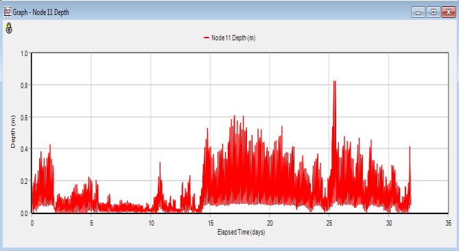
You can also read