RUBY CREST TRAIL - ELKO NEVADA - Road Trip Ryan
←
→
Page content transcription
If your browser does not render page correctly, please read the page content below
RUBY CREST TRAIL - ELKO NEVADA
                        Rating: Advanced Backpack
                        Length: 3-4 days / 35 miles
                        Gear: Standard Backpacking Gear / Water Carrying Capacity
                        Maps: Harrison Pass, NV; Green Mountain, NV; Franklin Lake NW,
                        NV; Ruby Dome, NV;
                        Water: Intermittent. Be sure to have the ability to carry a full days
                        worth.
                        Season: Mid summer to early/mid fall
                        Notes: The shuttle between the north and south trailhead is about 65-
                        ish miles one way and takes 1.5 hours (or more) to drive each way.
                        Waypoints:
                             Trailhead (2wd)                                       11T 626479mE 4464924mN
                                                                                    N40° 19' 31" W115° 30' 40"
                             Trailhead (4x4)                                       11T 627799mE 4468743mN
                                                                                    N40° 21' 34" W115° 29' 42"
                             Minor Jct. Right                                      11T 627696mE 4468721mN
                                                                                    N40° 21' 33" W115° 29' 46"
                             Jct - Right                                           11T 627432mE 4468914mN
                                                                                    N40° 21' 40" W115° 29' 57"
                             4-way. Stay straight.                                 11T 626436mE 4469867mN
                                                                                    N40° 22' 11" W115° 30' 39"
                             Small Spring #1                                       11T 626234mE 4470745mN
                                                                                    N40° 22' 40" W115° 30' 47"
                             Very Small Spring #1                                  11T 625619mE 4471744mN
                                                                                    N40° 23' 13" W115° 31' 12"
                             ATV Trail End                                         11T 625079mE 4471974mN
                                                                                    N40° 23' 20" W115° 31' 35"
                             Wilderness Boundary                                   11T 625225mE 4472355mN
                                                                                    N40° 23' 33" W115° 31' 28"
                             Small Spring #2                                       11T 625320mE 4472808mN
                                                                                    N40° 23' 47" W115° 31' 24"
                             Gilbert Jct. - Stay Right                             11T 625282mE 4473365mN
                                                                                    N40° 24' 05" W115° 31' 25"
                             Spring #1                                             11T 625586mE 4473445mN
                                                                                    N40° 24' 08" W115° 31' 12"
                             McCutcheon Jct - Stay Right                           11T 626549mE 4474079mN
                                                                                    N40° 24' 28" W115° 30' 31"
                             Spring #2                                             11T 626560mE 4474078mN
                                                                                    N40° 24' 28" W115° 30' 30"
                             Spring #3                                             11T 626661mE 4474343mN
                                                                                    N40° 24' 36" W115° 30' 26"
                             Spring #4                                             11T 627049mE 4478179mN
                                                                                    N40° 26' 40" W115° 30' 07"
                             South Fork Jct - Stay Straight                        11T 626383mE 4477562mN
                                                                                    N40° 26' 21" W115° 30' 35"

      Ruby Crest Trail - Elko Nevada - Road Trip Ryan, LLC - Copyright 2006-2021                                 1/9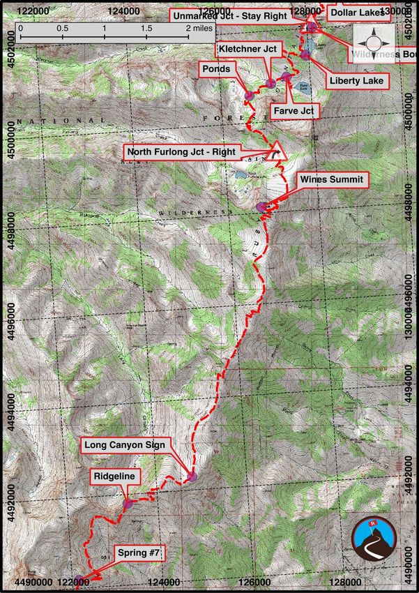
Faint Middle Fork Jct - Stay Straight                 11T 627027mE 4478483mN
                                                                                                       N40° 26' 50" W115° 30' 07"
                                                North Fork Junction - Right                           11T 628394mE 4479178mN
                                                                                                       N40° 27' 12" W115° 29' 09"
                                                Spring #5                                             11T 629363mE 4479177mN
                                                                                                       N40° 27' 12" W115° 28' 28"
                                                Overland Lake                                         11T 630946mE 4480042mN
                                                                                                       N40° 27' 39" W115° 27' 20"
                                                Overland Jct - Stay left                              11T 631248mE 4480198mN
                                                                                                       N40° 27' 44" W115° 27' 07"
                                                Spring #6                                             11T 630996mE 4480572mN
                                                                                                       N40° 27' 56" W115° 27' 17"
                                                Waterfall                                             11T 630623mE 4480861mN
                                                                                                       N40° 28' 05" W115° 27' 33"
                                                Spring #7                                             11T 630795mE 4481769mN
                                                                                                       N40° 28' 35" W115° 27' 25"
                                                Ridgeline                                             11T 631861mE 4483472mN
                                                                                                       N40° 29' 29" W115° 26' 39"
                                                Long Canyon Sign                                      11T 633286mE 4484054mN
                                                                                                       N40° 29' 47" W115° 25' 38"
                                                Wines Summit                                          11T 634817mE 4490003mN
                                                                                                       N40° 32' 59" W115° 24' 28"
                                                North Furlong Jct - Right                             11T 635147mE 4491250mN
                                                                                                       N40° 33' 40" W115° 24' 13"
                                                Ponds                                                 11T 634554mE 4492458mN
                                                                                                       N40° 34' 19" W115° 24' 37"
                                                Kletchner Jct                                         11T 635023mE 4492729mN
                                                                                                       N40° 34' 28" W115° 24' 17"
                                                Farve Jct                                             11T 635369mE 4492885mN
                                                                                                       N40° 34' 32" W115° 24' 02"
                                                Liberty Lake                                          11T 635795mE 4493362mN
                                                                                                       N40° 34' 48" W115° 23' 44"
                                                Wilderness Boundary                                   11T 635934mE 4493977mN
                                                                                                       N40° 35' 08" W115° 23' 37"
                                                Unmarked Jct - Stay Right                             11T 635913mE 4494075mN
                                                                                                       N40° 35' 11" W115° 23' 38"
                                                Lamoille Lake Jct                                     11T 636071mE 4494801mN
                                                                                                       N40° 35' 34" W115° 23' 31"
                                                Stock Trail Jct - Stay Right                          11T 636122mE 4494825mN
                                                                                                       N40° 35' 35" W115° 23' 29"
                                                Dollar Lakes                                          11T 636470mE 4494865mN
                                                                                                       N40° 35' 36" W115° 23' 14"
                                                Trailhead - Lamoille Canyon                           11T 637422mE 4496080mN
                                                                                                       N40° 36' 15" W115° 22' 33"

Hype
With 314, Nevada has more mountain ranges than any other state. The Ruby Mountains, south of Elko, are
often touted as one of the crown jewels of the Nevada ranges. Lamoille Canyon, the most visited area of the
range, has been described by some as the Yosemite of Nevada. I'm not sure I would go quite that far, but the
Ruby Range is indeed beautiful, remote, and has an excellent thru hike that visits a large chunk of it.

The Ruby Crest Trail is between 33 and 37 miles depending on who you ask. With small side trips for
camping, it clocked in at 35 miles by my count. The hike offers a bit of everything, from lower elevation
sagebrush hiking to a stunning ridgeline hike at about 10,000 ft. Though exquisite and offering relatively easy

                         Ruby Crest Trail - Elko Nevada - Road Trip Ryan, LLC - Copyright 2006-2021                                 2/9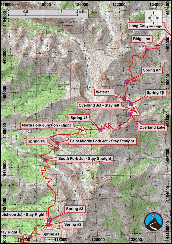
access, the Ruby Crest Trail doesn't seem crowded. Sections near Overland Lake on the mid portion of the
trail and Lamoille Canyon at the northern trailhead are frequently visited, but the rest feels wild and isolated.
This makes an excellent 3-4 day outing, though some may want to push it to 5 days. Be warned, this is an
advanced hike and requires skill, fitness, and experience. The most difficult section on the Ruby Crest is
difficult because of its elevation and lack of water. On our trip, we did about 14 miles between water sources,
crossing several summits en route.
Lack of water on the big day is a major concern. Be prepared to cover 14 miles between water sources. In mid-
summer, there may be snow to melt along the ridge, but too early in the summer and the passes may be
tough or dangerous to cross. I would recommend mid-July through early to mid-September as the prime time
to visit. Fall brings with it an explosion of colors as the leaves change.
Notes: Be mindful of thunderstorms, much of the hike is above or near treeline. Dogs are allowed on
the trail and our dog Abby had a great trip. If bringing a dog, however, be sure to carry enough water
for them and yourself on the big day. For our group of 2 + dog, we carried nearly 2 gallons of water
between us. The map shows where we found water on an early September trip / average snow year. It
can be used as a guide, but if getting low, never pass up the opportunity to fill up. Many springs dry up
by late summer.
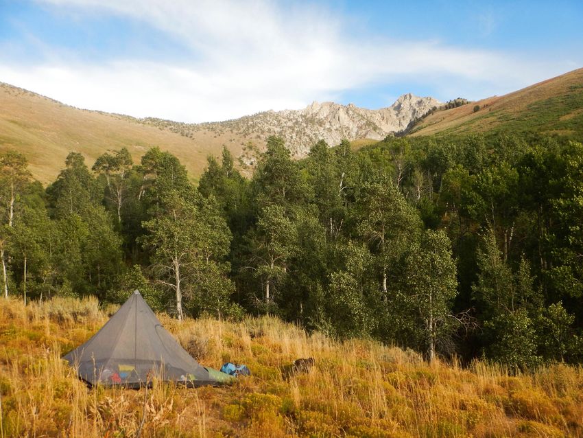
Camping can be a bit problematic as many areas have steep hillsides and not much flat ground to
pitch a tent on. The description below breaks the trip into 3 nights/4 days and ends each day at a good
camping spot. Smaller groups will have an easier time finding good camping.
The hike can be done from north to south, or south to north. If hiring a shuttle, the drivers all
recommend south to north. This would be my recommendation as well. The scenery gets better and
better each day if heading from the south.
Trails Worth Hiking (https://www.buzzsprout.com/1235132/) did a great podcast episode on the Ruby
Crest trail (episode 7), including interviewing Road Trip Ryan about our experience on the trail. Well
worth a listen, as well as the other Trails Worth Hiking Episodes. You can listen to it on your favorite
podcast app, or at https://www.buzzsprout.com/1235132/6168730 (https://www.buzzsprout.com
/1235132/6168730) .
Tags: hike, wildflowers, fall colors, dog friendly, advanced, access: high clearance
Trailhead
The Lamoille Trailhead (Recommended exit trailhead)
From downtown Elko, take 5th Street south, which becomes state road 227. This is well signed for Lamoille
Canyon. From Elko, stay on 227 for about 19 miles to the signed Forest Road 660 on the right. Signed for
Lamoille. Follow the road to its ends in 12 miles. This is the exit trailhead. There is a toilet at the trailhead, but
no camping. Thompson Canyon Campround is part way up the canyon, but can fill up on weekends. See
Reserve America for reservations.
Ruby Crest Trail - Elko Nevada - Road Trip Ryan, LLC - Copyright 2006-2021 3/9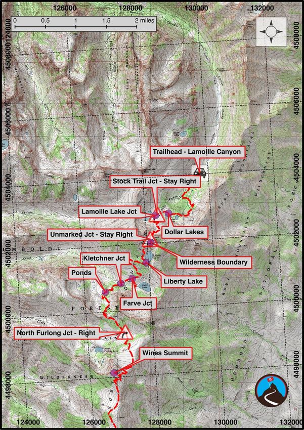
To Harrison Pass (Trailhead)
From the ends of the road, go back down Lamoille Canyon to 227. Go left (west) on 227. Follow this back 12
miles toward Elko. Turn left onto state road 228. (signed, major junction)

Follow 228 south for 40.1 miles. It passes through the incredibly small town of Jiggs, then continues south
before turning east and heading up to the pass. Just before the pass, the road turns to good graded dirt. It
should be reachable by all in most conditions. The pass offers good views to the east. Park at the large
parking are if you have a low clearance 2wd vehicle.

Route
Day 1 - From Harrison Pass to the South Fork (10 miles from Harrison Pass / 8.2 from the 4wd
Trailhead)
From Harrison Pass, walk or drive the jeep road. Stay on the obvious main road and several small forks. It is
about 2.8 miles to where the jeep road makes a left on the ridge and flattens out. There is a parking area here
and trailhead sign. If driving, I would recommend parking here.

Continue along the jeep road, staying right at the first junction, again on the obvious main road. It contours
around with several more minor side roads. Ignore this. The further you get, the narrower the road gets and
the more it becomes an ATV trail. The trail then crosses the Wilderness Boundary and begins a mellow
meander in and out of the many side canyons. A ridgeline makes a good lunch spot before the descent to the
South Fork of Smith Creek. There were several shallow streams crossing the road when we hiked this route
early September.

On the south bank of the South Fork of Smith Creek are several good campsites. The camping is just OK,
though, as the area seems to be pretty heavily used by livestock. We continued on and camped in the Middle
Fork, but flat ground was very hard to come by.

Day 2 - South Fork of Smith Creek to Overland Lake (5.75 miles with a steep elevation gain over the
pass)
The trail climbs to the ridge, meanders down to Middle Fork of Smith Creek, then climbs slightly before making
a fairly steady traverse to the headwaters of the North Fork of Smith Creek. If needed, there are quite a few
good camping areas in the North Fork, though they may be a bit off the trail.

From the headwaters of the North Fork, fill your bottles at the last spring, right where the trail begins its series
of steep switchbacks. The character of the hike begins to change as the hike climbs to the ridge. Big views
present themselves and you begin to see north to the scenery you will encounter in the next couple of days.

From the ridge, the trail switchbacks down to Overland Lake. There are quite a few good campsites along the
lake, and the old cabin makes for an interesting site.

Day 3 - Overland Lake to North Furlong or Farv Lake (12.1 mile to North Furlong Junction / about 15
miles to Farve Lake)
The big day! From Overland Lake, the trail descends to a junction. Go left here, as the trail contours along the
side of the range. A waterfall on the left before the trail begins climbing is the last reliable water for 12-13
miles. Stock up!

The trail climbs, switchbacks, and finally reaches the ridge and overlooks Log Canyon to the west. Big views
from here on out! Catch your breath and start climbing to the first of 5 summits. The trail, though up and down,
is never particularly steep. After a long traverse, the trail makes a steeper climb to near the summit of Wines
Peak. The true summit is a short distance west of the trail and worth the side trip.

                          Ruby Crest Trail - Elko Nevada - Road Trip Ryan, LLC - Copyright 2006-2021               4/9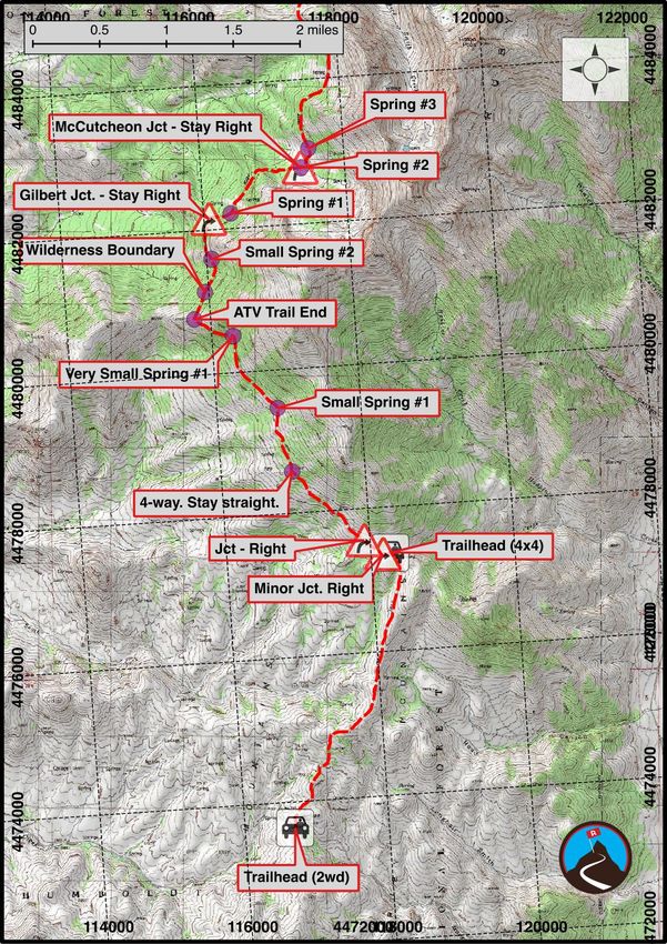
From Wines, the trail descends to the North Furlong Junction and a great rest spot in the trees. In wet times,
there will be flowing water at the junction (there wasn’t when we were there). If not, it is a 20 or so minute walk
to North Furlong Lake and water. If you don't need water, I would recommend continuing on to Farve Lake.
Continue north on the trail, crossing a final minor ridge for the day. The scenery changes dramatically in this
section and is stunning. A few ponds on the left of the trail a short distance before Kleckner Creek offer the
first water and decent camping.

At Kleckner Creek, go right. The trail climbs a short distance to the Farve Lake junction. A short distance from
the main trail, Farve Lake has quite a few excellent campsites or wander south from Farve to the less visited
Castle Lake.

Day 4 - To Lamoille Trailhead (5.25 miles)
From Farve Lake, head back to the main trail. The final day is short, scenic, and goes by quite fast. The trail
climbs to Liberty Lake, a stunning lake set in a hanging valley. The lake is a very popular destination from the
Lamoille Trailhead.

Passing Liberty Lake, it is 20 or so minutes to Liberty Pass and the dramatic views into Lamoille Canyon and
the exit trailhead. From the pass, the trail meanders down to very near Lamoille Lake which makes a good
side trip. A final junction just past Lamoille Lake offers a stock route (left) back to the trailhead, or the hiker
route (right). Go right, as the trail passes the charming Dollar Lakes before descending to the trailhead.

                          Ruby Crest Trail - Elko Nevada - Road Trip Ryan, LLC - Copyright 2006-2021                  5/9
Ruby Crest Trail - Elko Nevada - Road Trip Ryan, LLC - Copyright 2006-2021 6/9
Ruby Crest Trail - Elko Nevada - Road Trip Ryan, LLC - Copyright 2006-2021 7/9
Ruby Crest Trail - Elko Nevada - Road Trip Ryan, LLC - Copyright 2006-2021 8/9
Ruby Crest Trail - Elko Nevada - Road Trip Ryan, LLC - Copyright 2006-2021 9/9
You can also read


