NEXT develops new satellite-imagery derived products for mineral exploration and environmental monitoring
←
→
Page content transcription
If your browser does not render page correctly, please read the page content below
16 August 2021

NEXT develops new satellite-imagery derived products for mineral
exploration and environmental monitoring
For this write-up, we invited Sebastian Teuwsen, Project Manager in Research and
Development; Energy, Mining and Resource Management at EFTAS Remote Sensing and
Transfer of Technology GmbH. EFTAS is an SME based in Münster, Germany, which provides
geoinformation and IT services based on remote sensing and GIS from a single source.
Sebastian is overseeing the remote sensing related research activities in the EU funded
Horizon 2020 New Exploration Technologies (NEXT) project.

Could you elaborate on the contribution of remote sensing to the ambitions of the NEXT
project?
Even before the start of the NEXT project, we gave a lot of attention to how we could help
our colleague partners in the consortium with the many tasks foreseen, by building on our
experience from previous exploration projects. We foremost took into consideration that a
minimal impact on the environment was requested by the Horizon 2020 Call for proposals to
which NEXT was submitted. Indeed, the Call specifically expected proposals to develop new
and more sensitive environmentally sound exploration technologies and solutions.
Furthermore, the Call requested to communicate the added value of a proposal to the local
communities around the exploration sites as well as to society at large for improving public
acceptance. Thus, one of the primary goals of the Call was to achieve a reduction of the
anthropogenic footprint in the field of exploration technologies and thereby strengthen and
increase the acceptance, and in this instance, of the Social License to Explore (SLE) on the part
of the public.
Remote sensing, through the use of unmanned aerial vehicles (UAVs) or satellite technology,
clearly presents itself as an ideal tool to achieve the goal of reducing the anthropogenic
footprint. However, it quickly became apparent that our technology would be of particular
interest in new areas identified for exploration and whose viability would normally first be
assessed in the field and in the laboratory. The fact that the Finnish study area partly includes
an area that is under the guidelines of the EU Natura 2000 directive played a very significant
role in this regard.

Could you elaborate on the nature on the remote sensing activities in the Finnish study
area?
Throughout the 3-year duration of NEXT, we worked in close cooperation with the mineral
exploration company Mawson OY, the permit holder of the Finnish study area. This approach
ensured that the methods and approaches used for exploration and monitoring purposes
were strictly oriented towards keeping in line with the environmental directives set by the
responsible authorities in Finland. This enabled us to develop several methods that can be
used in the future and are in full compliance with environmental protection regulations in
sensitive natural areas, including Natura 2000 sites. Although this effort required a substantial
amount of research, we were very much aware that exploration activities in these sensitive
areas are hotly debated not only in Finland but in all such areas around Europe.

Which, if any, particular difficulties did you encounter to test the remote-sensing based
technologies?
In fact, from the very outset of NEXT, we faced difficulties to adequately apply our remote-
sensing based technologies for the purpose of mineral exploration due to the dense
vegetation cover, particularly in the Finnish study area and to a large extent also in the Spanish
one. This is mainly because satellite-based remote sensing technology, regardless of which
optical sensors are used, can only be applied primarily in arid and sparsely vegetated areas.
This is due to the fact that signals from the vegetation cover and the tree canopy hide the
signals coming from the open ground or from the outcrops under investigation. Hence the
presence of a dense vegetation does not permit investigations with regard to outcropping
rocks and their mineralogy. The pros and cons of these test sites had already been a point of
discussion among the consortium at the initial meeting in Brussels in November 2016, i.e. at
a time when the NEXT research proposal was still being developed. Nevertheless, in the
course of the project, together with our colleague partners, we were able to test and develop

                                    This project has received funding from the European Union’s Horizon 2020
                                    research and innovation programme under Grant Agreement No. 776804

Disclaimer: This document reflects only the author’s views and the Community is not liable for any use that may be made of
the information contained therein.
good and, above all, very useful methods and products from the field of satellite remote
sensing in these densely vegetated areas.
Could you elaborate on type of satellite sensor data used and how these are linked to the
various methodologies you developed in NEXT?
Our methodologies are mainly based on the data collected by the sensors of the Sentinel
family of the EU-Copernicus programme, which also corresponds to a primary goal of the
Horizon 2020 Call for proposals to which the NEXT project proposal was submitted. However,
aside from Sentinel-1 and Sentinel-2 sensors we also relied on LandSat, ASTER and Hyperion
satellite imagery. The table below brings an overview of the various methods we developed
using the Sentinel-2 and Hyperion sensors for environmental monitoring in general and for
mineral exploration in particular.
Table 1: Overview of elaborated methods/datasets for mineral exploration and environmental
monitoring
Method Sensor Application Description
Vegetation Type Sentinel-2 Environmental Automated classification of vegetation
Mapping Monitoring types
Vegetation Change Sentinel-2 Environmental Checking vegetation vitality changes over a
Analysis Monitoring period of time in the area of interest
Map Check Sentinel-2 Environmental Automated check, to verify if there are any
Monitoring differences between the outcomes of a field
campaign and the remote sensing derived
products
Vegetation Structure Sentinel-2 Environmental Analysing compensation areas nearby the
Analysis Monitoring exploration area to detect areas with
similarly valuable environmental stockings
Element Sentinel-2 Mineral Analysing principal components of the
Concentrations Exploration outcropping rocks in the area of interest
Iron Feature Depth Sentinel-2 Mineral Analysing iron contents in the area of
(IFD) Exploration interest
Surface Reflectance EO1-Hyperion Mineral Cluster mapping relating to the spectral
Exploration reflectance of the bare soils in the area of
interest
This project has received funding from the European Union’s Horizon 2020
research and innovation programme under Grant Agreement No. 776804
Disclaimer: This document reflects only the author’s views and the Community is not liable for any use that may be made of
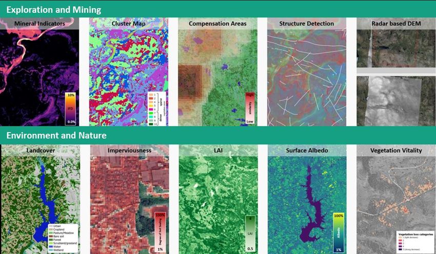
the information contained therein.In the figure below, our products derived from the application of these methodologies are
grouped, firstly in relation to their application for mineral exploration and mining purposes
(top), and then with respect to their usefulness in environmental monitoring (bottom).
This project has received funding from the European Union’s Horizon 2020
research and innovation programme under Grant Agreement No. 776804
Disclaimer: This document reflects only the author’s views and the Community is not liable for any use that may be made of
the information contained therein.“Many people, including acquaintances, friends and
family, ask me how I came to be a geologist, because this
profession it is widely considered to be something special
or even extraordinary in Germany. I grew up in a tranquil,
rural suburb of a medium-sized city in Westphalia. Already
as a young boy I was keenly exploring the wonders of
nature in the nearby forests and countryside. Later at
school, I focused more and more on subjects that are
concerned with the natural processes occurring on our
planet and how these shape our lives. After completing my
secondary education and a year of civilian service I moved
to the beautiful city of Münster. There I studied
geology/palaeontology and geophysics, and after a few
external internships I was lucky to get a job at the company
where I still work every day with pleasure and fulfilment.
Our application world of energy, mining and resource
management is highly multifaceted. Our remote sensing
applications range from soil contamination to water
management and supply, pore storage projects, ground
movement monitoring and mineral exploration projects.
The range of activities covered under the umbrella of
remote sensing is really incredibly vast!“
Sebastian Teuwsen is Project Manager in Research and Development; Energy, Mining and Resource
Management at EFTAS Remote Sensing and Transfer of Technology GmbH, based in Münster, Germany.
More about NEXT: www.new-exploration.tech
This project has received funding from the European Union’s Horizon 2020
research and innovation programme under Grant Agreement No. 776804
Disclaimer: This document reflects only the author’s views and the Community is not liable for any use that may be made of
the information contained therein.You can also read