Study on The Potential of Salaman River Water Resources for Raw Water Sources in Industrial Area of Jorong, Jorong Subdistrict, Tanah Laut ...
←
→
Page content transcription
If your browser does not render page correctly, please read the page content below
American Journal of Engineering Research (AJER)                        2021
                       American Journal of Engineering Research (AJER)
                                     e-ISSN: 2320-0847 p-ISSN : 2320-0936
                                             Volume-10, Issue-04, pp: 50-59
                                                              www.ajer.org
Research Paper                                                                                                       Open Access

      Study on The Potential of Salaman River Water Resources for
        Raw Water Sources in Industrial Area of Jorong, Jorong
          Subdistrict, Tanah Laut Regency, South Kalimantan
                                            Ridho Sholihin1, Mahmud2
  1
      Student, Civil Enggineering Graduate Program, Lambung Mangkurat University, Banjarmasin, Indonesia,
                                                       70123
       2
         Senior Lecture, Civil Enggineering Graduate Program, Lambung Mangkurat University, Banjarmasin,
                                                 Indonesia, 70123
                                        Corresponding Author: Ridho Sholihin

ABSTRACT : Entry industrial area of Jorong as a national strategic project area in the National Medium Term
Development Term Year 2020-2024 has made the provision of raw water becomes priority. Special target of this
research is getting the suitable place for providing raw water.In identifying the study of providing raw water
has accomplished by collecting primary data and secondary data also other supporting data. Data has thus
analyzed with hydrological analysis, hydraulic analysis, location analysis and quality of water and identify the
production capacity and raw water needs. All eligibility parameters is analyzed by Analytical Hierarchy
Process (AHP) method for getting the criteria of area which is the most worthy to become alternative raw water
intake, where the results show the weight of the Salaman River 0.506, the Riam Adungan river weight of 0.286,
and the weight of the Kematian River 0.208 which shows that the Salaman River is the most feasible.
KEYWORDS Industrial area of Jorong, providing raw water, Analytical Hierarchy Process (AHP) Salaman
River, Riam Adungan River, Kematian River.
---------------------------------------------------------------------------------------------------------------------------------------
Date of Submission: 20-03-2021                                                                  Date of acceptance: 04-04-2021
---------------------------------------------------------------------------------------------------------------------------------------

                                               I. INTRODUCTION
           Sub district of Jorong is one of sub districts in region Tanah Laut located at coordinate UTM X:
256188.17; Y: 9567899.55, on the west it is bordered on sub district of Batu Ampar and X: 296020.26; Y:
9569577.70, on the east it is bordered on sub district of Kintap. Sub district of Jorong has an area around 62.800
ha. Sub district of Jorong has been including as a national strategic project area is poured in regulations of the
ministry of industry in Constitution No 3 year 2014. The latest one is the presidential regulation of Indonesian
Republic No 18 year 2020 about The National Middle Term Development Plan year 2020 until 2024 which
explains that the area of industry Jorong has been included as a national strategic project area. One of its
priorities is raw water supply. The area of industry Jorong is centered on agro industry and steel. Nowadays it
has been prepared infrastructure such as port in Swarangan village, construction of road access, upgrading and
manufacturing of power plants, and other infrastructure.
           As is the area of industry Jorong expected will increase its regional income and the economy of
community around the area. To speed up development of the area of industry Jorong, then it is expected to all
elements of government for helping every aspects of support services which if it is connected to water resources,
it is related to the fulfillment of raw water.

                                       II. LITERATURE REVIEW
2.1 Standart Quality of Drinking Water
    Based on Permenkes RI No 32/2017 concerning environmental Health Quality Standards and Water Health
    Requirements for Sanitation Hygiene Needs, Swimming Pools, Solus Per Aqua and Public Baths. It means
    the water can fulfill requirements of physics, microbiologist, chemical, and radioactivity which are safe to
    be consumed for health.

 www.ajer.org                                                                                                              Page 50

 www.ajer.org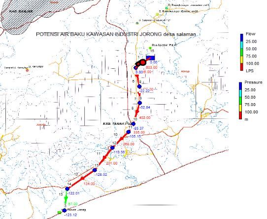
American Journal of Engineering Research (AJER)                                                      2021
2.2 Hydrological analysis
    The basis of planning needs hydrological data for water building planning and irrigating, a management of
    river, flood control et cetera. Therefore, there is a need for well planned and continuous program for the
    required data.
2.3 Projected Water Demand Calculation
    To calculate the projecting of clean water demand, standard criteria for domestic and non domestic water
    supply are needed.
2.4 The Projected Change in Population
    In analyzing population projections can use arithmetic method, geometric method, and Last Square
    method.
2.5 Network Transmission Simulation with the Epanet Program 2.0
    Epanet Program 2.0 is a hydraulic simulation program to view water quality behavior in drinking water
    distribution pipeline. It is based on window with many formats such as colored nodes, designs and tables
    depending on the type of variable input. Epanet modeling in a water transmission has many connections
    that are connected to several nodes. With this software, planning can be simulated so that it has several
    advantages in modeling transmission system.
2.6 Weighting by using Super Decition 3.2 Software
    Super decition 3.2 is free software which helps to support choosing decisions by applying Analytic
    Network Process (ANP) and Analytic Hierarchy Process (AHP)

                                          III. METHODOLOGY
3.1 The selection of location
    In study location is selected an upstream area which topographically and geographically support the
    availability of raw water.
3.2 The Research Object
    In This research is done in Kematian River village 33°47'54.34" LS, 114°58'0.64" BT), Riam Adungan
    River village (3°41'30.77" LS, 115° 9'38.20" BT) and Salaman River village (3°45'19.69" LS, 115°
    7'33.25" BT). Those villages are located in upstream area which supports the area of industry Jorong and
    irrigation area.
3.3 Research Flow
    Research flow can be described as follows :

 www.ajer.org                                                                                       Page 51

 www.ajer.org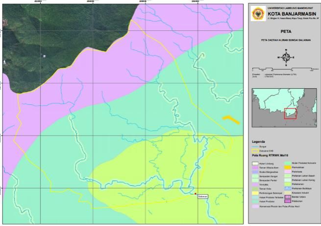
American Journal of Engineering Research (AJER)         2021

                         Figure. 1.Research Flowchart

www.ajer.org                                            Page 52

www.ajer.org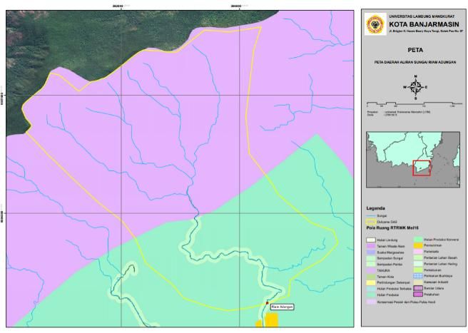
American Journal of Engineering Research (AJER)                                                                                     2021
                                                IV. RESULT AN DISCUSSION
4.1 The Testing of Water Quality
                                             Table. 1.The Result of Water Quality
                                                       The result of analysis                                    Governor
               No.        Parameter          AB-       AB-     AB-      AB-     AB-        Analysis Method      Regulations
                                              01        02      03       04      05
               1.         TSS (Mg/l)          21        2        2        2      6        Gravimetric           50
               2.      Temperature (oC)      28,7      28,7    28,7     28,7    29,3      Thermometric          Deviation 3
               3.         TDS (Mg/l)         303        75      87       64     139       TDS Meter             1.000
               4.        Conductivity                                                                           -
                                             0,517     0,112   0,126    0,093   0,210     Conductivity Meter
                            (Ms/cm)
               5.              DO            2,7       5,0      5,1     5,1     5,1       Electrometric         6
               6.          pH (Mg/l)         5,44      5,70     5,69    5,78    5,53      Potesiometric         6-9
               7.       Iron, Fe (Mg/l)      2,84      0,03     0,10    0,55    0,08      Spectrophotometric    0,3
               8.      Ammoniac, NH3                                                                            0,5
                                             0,17      0,12     0,11    0,14    0,02      Spectrophotometric
                             (Mg/l)
               9.      Manganese, Mn                                                                            0,1
                                              0,5       0,5     0,6      0,6     0,5      Spectrophotometric
                             (Mg/l)
               10.    Nitrite, NO2 (Mg/l)    0,007     0,002   0,004    0,004   0,003     Spectrophotometric    0,06
               11.    Sulfate, SO4 (Mg/l)      21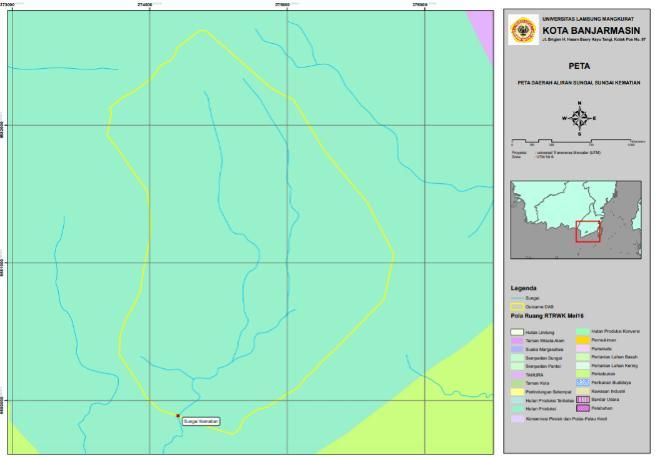
American Journal of Engineering Research (AJER)                                                                                         2021

                                      The Comparison of Projecting Raw Water Demand and Capacity Required
                  140

                  120

                  100

                  80

                  60

                  40

                  20

                   0
                        2019   2020          2021       2022                2023           2024             2025   2026   2027   2028
                                                               Total Capacity (L/s)   Maximum Daily (L/s)

                        Figure. 2. Comparison Chart of Projecting Raw Water Demand

Projecting raw water demand for community in the sub-district of Jorong projected until year 2028 is 119.63
liter/second at peak hours. Meanwhile, IPA’s capacity is only 20 liter/second. That is for the addition of
production capacity is much needed.

4.4 Network transmission simulation with Program of Epanet 2.0

              Figure. 3. Output of Hydrological Simulation Results for Riam Adungan River

The result of hydrological simulation by using epanet software states that it is required pumping system to drain
water to the area of industry Jorong. It is required pumping system by using parallel pump method to be able to
get head total in order to not losing preassure.

 www.ajer.org                                                                                                                           Page 54

 www.ajer.org
American Journal of Engineering Research (AJER) 2021
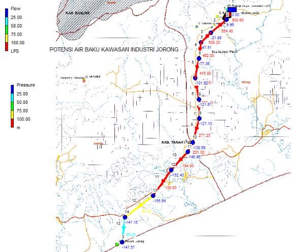
Figure. 4. Output of Hydrological Simulation Results for Salaman River
The simulation results above show the same results as the Riam Adungan river that it is required pumping
system to drain water to the area of industry Jorong.
Figure. 5. Output of Hydrological Simulation Results for Kematian River
Based on the result of hydrology simulation by using epanet program for raw water source in Kematian
River, it still needed the pumping system to flow water to the area of industry Jorong. It is caused the location of
raw water source has a high enough elevation namely 250 meter so that the pumping system does not require
high enough pump head because it has been helped by the gravity system so that the transmission system has
enough pressure to get into the area of industry Jorong.
www.ajer.org Page 55
www.ajer.orgAmerican Journal of Engineering Research (AJER) 2021
4.5 Spatial Suitability Analysis
Figure. 5. Analysis of spatial suitability of Salaman Watershed
From the image above, it is seen that the catchment area of Watershed Salaman which is in the
upstream is Nature Tourism Park, in the middle is conversion production forest and in the downstream is
plantation. From the spatial plan, it seems that there is no problem if there are construction activities in the
downstream.
Figure. 6. Analysis of spatial suitability of Riam Adungan Watershed
From the image above, it is seen that the catchment area in Riam Adungan Watershed which is in the
upstream is Nature Tourism Park, in the downstream is conversion production forest. From the spatial plan, it is
seen that there is no problem if there are construction activities in the downstream.
www.ajer.org Page 56
www.ajer.orgAmerican Journal of Engineering Research (AJER) 2021
Figure. 7. Analysis of spatial suitability of Kematian River Watershed
From the image above, it is seen that the catchment area in Kematian Watershed in a whole section is
conversion production forest. From the spatial plan, it is seen that there is no problem if doing construction
activities.
4.6 Site Feasibility Analysis by using Analytical Hierarchy Process (AHP) Method
In decision making by using AHP can be grouped into 3 (three) compositions as follows ;
Figure. 8. The Structure of The Subject Matter Identification of The Problem
With the aim of raw water, there are 7 (seven) criteria which is made in choosing 3 (three) locations.
They are Riam Adungan river village, Salaman river village, and Kematian river village. Furthermore, those
criteria are sorted from the most influential to the least influential, and the points are assessed in the criteria
matrix comparison as follows.
www.ajer.org Page 57
www.ajer.orgAmerican Journal of Engineering Research (AJER) 2021
Table. 4. The Table of Analysis Results Per Location
RIAM ADUNGAN
SALAMAN RIVER KEMATIAN RIVER
RIVER
Dischargetion 831.4375 Liter/second 103.781 Liter/second 161.066 Liter/second
Continuity Most Stable (1) Most Stable (3) Most stable (2)
Water Quality 1 3 2
20.9 Km to the nearest 28.6 Km to the nearest
Service Distance 23.7 Km to the nearest SPAM
SPAM SPAM
Elevation From +19 m to +7m from +147 m to +20 m from +53 m to +7 m
2. the flat slope is 1.5%- 3. the flat slope is 1.9%-
Traverse Trajectory 1. the flat slope is 2%-2.4%
1.6% 2.1%
2 In upstream is conversion
3. One part is conversion
production forest area, in the
1. The whole is in conversion production forest area, and
Clear Location middle is production forest,
production forest some others is in
in the downstream is
production forest
plantation area
From the previously obtained analysis, there were 7 (seven) factors for the three river locations, then assessed
subjectively for each variable relatively. After that, it is appointed the highest variable for the most influential
results. The results of the assessment are made ranking as follows
Table. 5. The Table of Ranking Location
Location Weight Ranking
SALAMAN RIVER 0.506 1
KEMATIAN RIVER 0.208 3
RIAM ADUNGAN RIVER 0.286 2
TOTAL 1
For the three assessed river locations, it can be concluded that Salaman river gets the highest ranking (0.506),
compared with Riam Adungan river (0.286) and Kematian river (0.208)
4.7 Weighting by using the software of Super Decision version 3.2
The results of manual measuring compared with the results by using the software of Super Decision
version 3.2 generate ranking data as follows
Figure. 9. The Results of Ranking Location by Super Decision version 3.2
From the data above, it seems like manual measuring and using software shows the same results for the highest
feasibility for the source of raw water is Salaman River.
V. CONCLUSION
The results of this research are sufficient to prove that based on the weighting of 3 (three) areas tested
by using AHP method which consist of discharge variable, continuity, water quality, trajectory tracing, and free
location shows the resulting weight of Salaman River is 0.506, Riam Adungan River is 0.286 and Kematian
River is 0.208. If the weights are compared with the software of Super Decision version 3.2, it shows that
Salaman River is 0.50351, Riam Adungan River is 0.2918, Kematian River is 0.20469. Both of results show that
Salaman River is the most feasible location for the raw water sources.
www.ajer.org Page 58
www.ajer.orgAmerican Journal of Engineering Research (AJER) 2021
REFERENCES
[1]. Amalia. 2011, Analytical Hierarchy Process (AHP) http://repository.dinus.ac.id/docs/ajar/2016_Ankep_08_-_AHP.pdf (accessed on
2020-08-20).
[2]. ChandraWidjaja, Robertus. 2011, Rekayasa Sungai dan Pantai. Banjarmasin: Universitas Lambung Mangkurat Press.
[3]. ChandraWidjaja, Robertus. 2010, Hidrologi Rawa. Banjarmasin: Universitas Lambung Mangkurat Press.
[4]. Dwi, Ariati. 2015. Hidrologi. Jakarta: Universitas Pancasila.
[5]. The Directorate General of Copyrights Works of Public Works. 2007. Rencana Program Investasi Jangka Menengah Bidang
PU/Cipta Karya. Jakarta: Studio Jakstraf BPCK.
[6]. Minister of Settlement and Regional Infrastructure. 2004. Pengisian Kekosongan Data Hujan Dengan Metode Korelasi
Distandardisasi Non linier Bertingkat. Public Works Department Construction and Building Guidebook..
[7]. South Kalimantan Governor Regulation Number 05 Year 2007 about the Allocation and Quality Standards for River Water.
[8]. Haryono, S. 2006, Mekanika Fluida. Jakarta: PT. Mediatama Saptakarya.
[9]. Ministry of Industry of the Republic of Indonesia. 2015. Laporan Akhir Penyusunan Masterplan Kawasan Industri Jorong.
[10]. Syaifudin, Thalis. 2016, Metode AHP dalam Kajian Lingkungan di https://id.scribd.com/doc/313663478/Metode-Ahp-Dalam-
Kajian- Lingkungan (Accessed 2020-08-21).
[11]. Super Decition.com. about Super Decisions. di http://www.superdecisions.com/about/ (Accessed 2020-09-12).
[12]. Triatmojo, B. 1992, Hidrolika I. Yogyakarta: Beta Offset.
Ridho Sholihin, et. al. "Study on The Potential of Salaman River Water Resources for Raw Water
Sources in Industrial Area of Jorong, Jorong Subdistrict, Tanah Laut Regency, South Kalimantan
.”American Journal of Engineering Research (AJER), vol. 10(4), 2021, pp. 50-59
www.ajer.org Page 59
www.ajer.orgYou can also read