Rākaia River to Rangitata River - Walking - Walking Access NZ
←
→
Page content transcription
If your browser does not render page correctly, please read the page content below
4/15/2021 Rākaia River to Rangitata River — NZ Walking Access Commission Ara Hīkoi Aotearoa
Rākaia River to Rangitata River
Walking
Dif culty
Hard
Length
69.7 km
Journey Time
4 days
Region
Canterbury
Sub-Regions
Ashburton District , Selwyn District
Part of Collections
Te Araroa - New Zealand's Trail , Te Araroa - South Island
Track maintained by
Te Araroa Trail Trust
https://www.walkingaccess.govt.nz/track/rakaia-river-to-rangitata-river/pdfPreview 1/6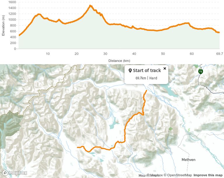
4/15/2021                          Rākaia River to Rangitata River — NZ Walking Access Commission Ara Hīkoi Aotearoa

    This Te Araroa section, from the Rākaia River to the Hakatere Heron Road, starts on a public
    access easement over Glenariffe Station, 34km from SH77. It then crosses the 60000ha Hakatere
    Conservation Park before nishing in the Heron Basin on a paper road that runs through
    Castle Ridge Station.

    It’s an area rich in high country history dating back to 1857 when Clent Hills Station was rst
    farmed as a 20000ha run under licence from the Crown. Over the years the station has survived
    many incarnations the most recent being the Nature Heritage Fund purchase of 10000ha, which
    reduced the station to a rump of 2000ha within the Heron Basin.

    The Clent Hills pastoral lease was in the Buick family from 1923 to 1982. The rst 3 years of this
    tenure was spent eradicating rabbits before stock could be reintroduced to the property.

    Glenrock Stream to Comyns Hut - 15.7km / 4-5hr
    From the DOC sign notifying “Access to North Branch Ashburton Stream” the track follows
    markers through farm land up the true right side of Glenrock Stream - look out for electric
    fences. At the 1.7km mark the track crosses the stream and then merges with a farm track that
    begins to climb towards the Conservation Park boundary. Along the way the track passes a stand
    of Kōwhai trees. No camping is permissible until inside the Conservation Park boundary.

    From the Conservation Park boundary the route zig-zags up an old farm track to Turtons Saddle
    (1120m). Beyond the saddle travel remains on the farm track and is initially east and upwards
    but soon turns south sidling then descending towards the Turtons Stream’s true left bank. The A-
    frame hut toilet becomes visible in the lower portions of the descent.

    After 8.7km the track reaches Turtons Stream, which is the rst water source en route that is both
    reliable and safe to drink. The track remains on the true left and crosses Ensor Stream 1.5km
    before A-Frame Hut, a tidy 3-bunk hut near the Comyns Stream’s con uence with Turtons Stream.
    It takes about an hour from the saddle to reach this hut.

    Beyond A-Frame Hut the track continues down the true left of Turtons Stream for about 2km. This
    is to the rst of 4 river crossings in close succession. The track then climbs and descends into
    Mutton Gully. Once out of this gully, Turtons Stream is forded a nal time. It's then an easy 700m
    walk to Comyns Hut (8 bunks).

https://www.walkingaccess.govt.nz/track/rakaia-river-to-rangitata-river/pdfPreview                                     2/6
4/15/2021 Rākaia River to Rangitata River — NZ Walking Access Commission Ara Hīkoi Aotearoa
The current Comyns Hut was built in 1957 to replace the original and derelict hut, which was
built in the 1890s and still stands nearby. The ‘new’ hut is basic but was improved following
restoration work in 2008. The hut door and walls act as an informal and historic register and
make interesting reading.
Comyns Hut to Double Hut junction - 16km / 6-8hr
Note: This part of the track is rough and unformed. Trampers are required to pick their own
route between markers which, in poor weather, may not be visible from one to the next. The
physical and navigational challenges rise accordingly.
A marker behind the hut shows the route heading west up the North Branch Ashburton River
towards Round Hill Creek. Travel quickly becomes con ned to the stream bed and involves
frequent river crossings. These are straightforward in normal ows.
Round Hill Creek joins North Branch Ashburton as the latter heads north towards Petticoat Lane.
From this con uence Te Araroa continues up Round Hill Creek, past Logan Stream, and then
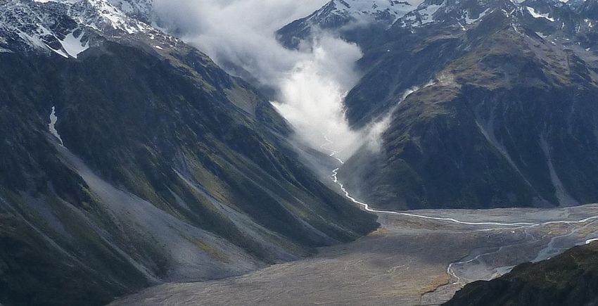
departs to begin the ascent towards Clent Hills Saddle (1480m). On a clear day the saddle
affords great views of the Longman Range, Ricki Spur and the wider Lake Heron Basin.
Care needs to be taken to ascertain the correct route beyond the saddle. Do not descend.
Instead continue to the right along the saddle and link to the upper-most track crossing a large
scree slope. On the far side of the scree the route continues to sidle through tussock to the next
ridge. Marker poles become clear again along the way.
From the ridge the poles lead down and to the right, diagonally away from the Swin River.
Eventually, after crossing 3 further scree slopes, the track reaches a dilapidated fence along
another ridge line.
Follow the fence line down the ridge to a rock cairn and arrow, which indicate the way down and
to the right towards the next pole and ultimately to an unnamed stream, which is a tributary to
the Swin River. Once across this stream the nal climb begins towards the Mellish Saddle.
The route down from the saddle becomes easier and remains above the true left bank of Mellish
Stream. It emerges into the wider Heron Basin and passes a sign-posted junction with a side
trail out to the road end at Lake Heron. Continue on the main track for about 1km to another
junction near the Swin River, which is crossed on foot but seldom an issue. From here Double Hut
(6 bunks) is 1km away on another side trail. Double Hut has 6 bunks and is in reasonable
condition.
https://www.walkingaccess.govt.nz/track/rakaia-river-to-rangitata-river/pdfPreview 3/64/15/2021 Rākaia River to Rangitata River — NZ Walking Access Commission Ara Hīkoi Aotearoa
The side trail to the right provides an exit to the Lake Heron Car Park and then to Hakatere
Heron Road. Once on the road it is a few 100m to the right around the lake shore to Lake Heron
Campground. Or turn left for 16.3km to Ashburton Gorge Road and then left another 39.6km to Mt
Somers Village where there is a tavern for meals, a general store and camping accommodation.
Double Hut junction to Hakatere Heron Road (via Manuka Hut) - 14km
/ 3-4hr
The track continues south for 6.4km across grassy and gravel ats passing the Seagull and
Mānuka Lakes along the way. This is to a junction from where Mānuka Hut (6 bunks) is hidden
300m upstream and to the left.
Note: The next reliable water source on Te Araroa beyond Mānuka Hut is on
the Clearwater Track (17.3km ahead).
Beyond the Mānuka Hut junction Te Araroa continues south for a little over 2km and then turns
west to climb to the ridge on Emily Hill’s south ank. The poled track line then sidles down
through matagouri bush and spear grass to the ats. From here it's easier going across to a
carpark at Lake Emily. At this point the track leaves the Hakatere Conservation Park and joins
with a marked unformed road that divides into Castle Ridge Station. Trampers should take care
to follow the markers to avoid straying onto private property.
Its 5km from Mānuka Hut to the Lake Emily carpark and then another 3.2km on the Castle Ridge
paper road to Hakatere Heron Road. This is where the Clent Hills Track ends. There is a farm
gate across the paper road about 600m before the nish point. This gate should be left as it is
found (open or closed).
For trampers continuing south, turn left onto Hakatere Heron Road and walk 4.4km to
the Clearwater Track trail head. This is on the right hand side of the road just beyond Buicks
Bridge.
Clearwater Track - 21km / 4-6hr
Note: There are no huts en route but camping is permitted at any point down this track.
https://www.walkingaccess.govt.nz/track/rakaia-river-to-rangitata-river/pdfPreview 4/64/15/2021 Rākaia River to Rangitata River — NZ Walking Access Commission Ara Hīkoi Aotearoa
This high county track passes through the Hakatere Conservation Park on land formally
comprised in the 9119ha Hakatere Station. This pastoral leasehold property was purchased by
the Nature Heritage Fund in October 2007 and returned to the conservation estate. Free public
access is now afforded, as is protection to signi cant wetlands and expansive landscapes.
From the south side of Buicks Bridge, which crosses the South Branch Ashburton River, marker
poles lead westward across easy open country. This is towards the gap between Mt Guy and Dogs
Hill. At the 5km mark the track crosses a fence line and later it joins an old farm track, where it
stays for another 5km. At this point the marked track turns left and heads towards a saddle at
the western end of Mt Guy. It passes a tarn along the way.
From the Saddle there are sweeping views over Lake Clearwater towards the Harper Range, of
Mt Potts, and to, then beyond, the Rangitata River. Follow the fence line down to the creek at the
base of the hill. The track then heads south-west towards the head of Lake Clearwater and joins
with another old farm track, which continues towards the Potts River but stops at a gate. Te
Araroa heads northward here to avoid crossing private property then bends around towards the
lip on the Potts River's true left bank. Once on the lip the track stays high and follows the fence
line. It then drops steeply into a gully, which opens to the Potts River bed. If the Potts River is
running clear then the best travel is usually downstream direct to the carpark at the road
bridge.
If the Potts is discoloured this exit will be impassable. The proper course then is up the other
side of the gully. Trampers are then able to remain on the Potts side of the fence line through to
the road. From here it’s a short walk down hill to the car park and trailhead.
Its 18.5km to the left on Hakatere Potts Road to Ashburton Gorge Road, then on to Mt Somers
Village and Methven. Its 3km to the right on Hakatere Potts Road to Mt Potts Lodge.
Conditions:
Potential Hazards:
Farming operations
River crossings - Never cross ooded rivers
Small stream crossings
Track exposed to sun, wind or cold
Weather extremes
Few water sources - be sure to ll at Mānuka Hut
https://www.walkingaccess.govt.nz/track/rakaia-river-to-rangitata-river/pdfPreview 5/64/15/2021 Rākaia River to Rangitata River — NZ Walking Access Commission Ara Hīkoi Aotearoa
How to get here
Northern Start: Glenrock Stream, Double Hill Run Road
Southern End: Potts River Bridge carpark, Hakatere Potts Road
Track Elevation and Map
More information
Te Araroa Canterbury trail notes, including information about accommodation, transport and
resupplying
Page last updated: Jan 6, 2021, 9:14 AM
https://www.walkingaccess.govt.nz/track/rakaia-river-to-rangitata-river/pdfPreview 6/6You can also read