STEPWISE REFINEMENT OF LOW RESOLUTION LABELS FOR EARTH OBSERVATION DATA: PART 2 - DLR
←
→
Page content transcription
If your browser does not render page correctly, please read the page content below
STEPWISE REFINEMENT OF LOW RESOLUTION LABELS
                             FOR EARTH OBSERVATION DATA: PART 2

        Daniele Cerra, Nina Merkle, Corentin Henry, Kevin Alonso, Pablo d’Angelo, Stefan Auer,
       Reza Bahmanyar, Xiangtian Yuan, Ksenia Bittner, Maximilian Langheinrich, Guichen Zhang,
                              Miguel Pato, Jiaojiao Tian, Peter Reinartz

                                   {FirstName.LastName}@dlr.de
        Remote Sensing Technology Institute, German Aerospace Center (DLR), Oberpfaffenhofen

                        ABSTRACT                                   labels and refining the decision tree yields an improvement
                                                                   for all the semantic classes of interest.
    This paper describes the contribution of the DLR team
ranking 2nd in Track 2 of the 2020 IEEE GRSS Data Fusion
Contest. The semantic classification of multimodal earth                              2. METHODOLOGY
observation data proposed is based on the refinement of low-
resolution MODIS labels, using as auxiliary training data          2.1. Enhanced Random Forest Classifier
higher resolution labels available for a validation data set.      In Track 2 of the IEEE Data Fusion Contest, the high-
The classification is initialized with a handcrafted decision      resolution semantic labels associated to the validation dataset
tree integrating output from a random forest classifier, and       became available. These were used to train the RF classifier
subsequently boosted by detectors for specific classes. The        architecture described in [3], allowing further improvements
results of the team ranking 3rd in Track 1 of the same contest     of the best results obtained in Track 1. The parameters of
are reported in a companion paper.                                 the classifier based on the implementation of the Scikit-learn
                                                                   python library are as follows: number of trees = 500, maxi-
                   1. INTRODUCTION                                 mum depth = 100 (longest branch in a tree), maximum leaf
                                                                   nodes = 100. Additionally, class imbalance within the train-
The 2020 Data Fusion Contest, organized by the Image Anal-         ing data was handled by setting the parameter “class weight”
ysis and Data Fusion Technical Committee (IADF TC) of              to “balanced”, which assigns a weight to each class inversely
the IEEE Geoscience and Remote Sensing Society (GRSS)              proportional to its frequency in the input data. We trained
and the Technical University of Munich, focused on large-          two models on different splits of data and different kinds of
scale land cover mapping from globally available multimodal        labels: the first one includes only the validation set with the
satellite data. The task is to train a machine learning model      high resolution labels disclosed for Track 2, while the second
for global land cover mapping based on weakly annotated            one contains all images from Europe and uses semantically
samples [1]. Training, validation and test data consist of         translated labels from the 2018 Copernicus CORINE data [4]
triplets of Sentinel-1 and Sentinel-2 images at 10 m/px spa-       from 2018 (for details on single classes see [3]).
tial resolution, and MODIS semantic labels resampled from              Visual inspection of the results suggested that the model
the original 500 m/px spatial resolution [2]. The 2020 con-        trained on the high-resolution validation labels yielded results
test comprised two challenge tracks: land cover classification     more consistent with respect to the training data, and made
with low-resolution labels using the described data (Track 1),     a better segmentation of natural classes such as Grasslands,
and the same problem with additional high resolution seman-        Wetlands and Barren with respect to the model trained on the
tic labels made available for training (Track 2). This paper       CORINE labels.
describes the approach developed at the German Aerospace
Center (DLR) ranking 2nd in Track 2. The described results
                                                                   2.2. Urban Areas Refinement
are refinements to the approach which ranked 3rd in Track 1
of the same contest, which is reported in a companion paper        The Urban class is initialized by the same RF used for Track
[3]. As a reminder, a graphical stepwise representation of         1, this time trained on the high-resolution labels for the val-
Track 1 approach for a sample validation image is reported in      idation dataset. The Urban mask is then expanded and re-
Fig. 1.                                                            fined using the same algorithm used for Track 1, employ-
     With respect to the results obtained in Track 1, training a   ing Gabor texture parameters, NDTI (Normalized Difference
Random Forest (RF) classifier on higher resolution semantic        Tillage Index) [5] computed from Sentinel-2, and brightness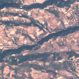
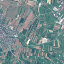
(a) Sentinel-2       (b) MODIS          (c) Decision Tree   (d) Reclassification   (e) Track 1 Results   (f) Reference Labels

Fig. 1. Reminder for main steps of the classification strategy for Track 1. From left to right: True color combination of Sentinel-
2 bands (a); coarse MODIS labelling at 500 m spatial resolution (b); output of the decision tree described in [3] (c); results after
reclassification using k-means (d); final results after post-processing (e); reference labels for the selected test image (f).

of Sentinel-1. Details on this step are reported in the com-
panion paper to this manuscript [3]. Both precision and re-
call for this class increase with respect to results for Track 1.
False alarms are reassigned to the classes Grassland, Shrub-
land or Barren according to a hard thresholding of the NDVI.
Although results in Table 1 show that the recall for the class
has an improvement in the order of 1% only, false alarms are
greatly reduced. Relevant examples are reported in Fig. 2.
Similar results have been obtained by training the RF on Eu-
ropean scenes with CORINE labels as defined in [3].

2.3. Grassland Refinement

The Grassland class as detected from the described Random
Forest classifier results better defined with respect to Track 1,
and is used as starting point for the final classification. The
class is improved by switching to Grassland pixels originally
classified as Forest having brightness value in the red band
of the Sentinel-2 images above a fixed threshold set at 550.
Finally, images detected as containing Wetlands but domi-
nated by Grassland labels in MODIS are also added to the
class. Grassland is the only class showing a major improve-
ment (around 20%) with respect to Track 1 results (see Table
1). Representative results are reported in Fig. 3.

2.4. Other Classes

The other classes are refined as follows.

   • The class Forest is expanded with the results of the
     Random Forest classification, and reassigned to the
     class Shrubland if values in the Short Wave Infrared
     (SWIR) bands of Sentinel 2 are above a fixed threshold                (a) Sentinel-2          (b) Track 1             (c) Track 2
     of 710, with an NDVI below 0.7. In spite of the spatial
     ambiguities introduced by the lower spatial resolution          Fig. 2. True color combination of Sentinel-2 bands (a) and
     of the SWIR bands (20 m), this increases the detection          results for selected test images in Track 1 and Track 2 (b, c),
     of Shrubland without degrading results for Forest.              showing improvements in urban area detection. For a legend
                                                                     ref. Fig. 1.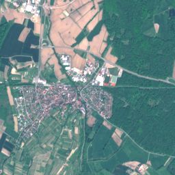
2.5. Evaluation of the Results

                                                                    The examples reported in Figs.2-4 can be only evaluated vi-
                                                                    sually, as at the time of writing the high resolution semantic
                                                                    labels have not been disclosed for the over 5000 images of
                                                                    size 256 × 256 contained in the test set. Results in terms
                                                                    of accuracy per class are reported in Table 1, along with the
                                                                    score for the best ranked teams.The accuracy for all semantic
                                                                    classes improves with respect to Track 1. Examples for the
                                                                    improvements in these classes are reported in Fig. 4.

    (a) Sentinel-2         (b) Track 1             (c) Track 2

Fig. 3. True color combination of Sentinel-2 bands (a) and
results for selected test images in Track 1 and Track 2 (b, c),
showing improvements in the class Grassland. For a legend
ref. Fig. 2.

                 Table 1. Classification results
        Class                       Track 1    Track 2
        Forest                      0.8012     0.8109
        Shrubland                   0.3538     0.3798
        Grassland                   0.4446     0.6299
        Wetlands                    0.4273     0.4388
        Croplands                   0.3704     0.4108
        Urban                       0.8140     0.8264
        Barren                      0.3556     0.4260
        Water                       0.9838     0.9860
        Average Accuracy            0.5688     0.6136
        Contest’s Best Results      0.5749     0.6142

   • The class Wetlands is expanded by considering im-
     ages satisfying the following conditions: (1) The im-
     ages contain pixels marked as Water or Wetlands in
     MODIS labels; (2) the variance in the red band for
     Sentinel-2 lies below a fixed threshold of 160, as wet-
     lands area appear homogeneous and exhibit a smooth
     texture; (3) the images do not contain strong scatterers
     in Sentinel-1, usually indicating man-made structures.
     If any of the listed conditions is not met, the class is re-
     assigned to one among the classes Barren, Brushland,               (a) Sentinel-2        (b) Track 1          (c) Track 2
     Forest, or Grassland according to the NDVI.                    Fig. 4. True color combination of Sentinel-2 bands (a) and
                                                                    results for selected test images in Track 1 and Track 2 (b, c),
                                                                    showing improvements in classes such as Forest and Crop-
   • Barren pixels in areas dominated by crops are assigned         lands, and a reduction of false alarms for classes Wetlands
     to the Croplands class.                                        and Urban. For a legend ref. Fig. 2.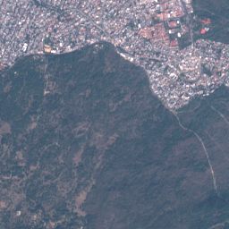
3. CONCLUSIONS

The 2020 IEEE GRSS Data Fusion Contest focused on the
classification of Sentinel-2 and Sentinel-1 data at 10 meters
spatial resolution, given MODIS-derived semantic annota-
tions at a coarser resolution of 500 m. In Track 2 of the
contest, additional semantic labels at 10 m spatial resolutions
are made available for part of the available dataset. This paper
describes the refinement steps taken to improve results with
respect to Track 1, for which our results are described in [3].
The produced classification maps ranked 3rd and 2nd in Track
1 and Track 2, respectively.

                  4. ACKNOWLEDGEMENT

The authors would like to thank the research group for Signal Pro-
cessing in Earth Observation at the Technical University of Munich
for providing the data used in this study, and the IEEE GRSS Image
Analysis and Data Fusion Technical Committee for organizing the
Data Fusion Contest.

                        5. REFERENCES

[1] N. Yokoya, P. Ghamisi, R. Haensch, and M. Schmitt, “2020
    ieee grss data fusion contest: Global land cover mapping with
    weak supervision [technical committees],” IEEE Geoscience
    and Remote Sensing Magazine, vol. 8, no. 1, pp. 154–157, 2020.
[2] M. Schmitt, L. H. Hughes, C. Qiu, and X. X. Zhu, “Sen12ms
    – a curated dataset of georeferenced multi-spectral sentinel-1/2
    imagery for deep learning and data fusion,” ISPRS Annals of
    Photogrammetry, Remote Sensing and Spatial Information Sci-
    ences, vol. IV-2/W7, pp. 153–160, 2019.
[3] D. Cerra, N. Merkle, C. Henry, K. Alonso, P. d’Angelo, S. Auer,
    R. Bahmanyar, X. Yuan, K. Bittner, M. Langheinrich, G. Zhang,
    M. Pato, J. Tian, and P. Reinartz, “Stepwise refinement of low
    resolution labels for earth observation data: Part 1,” in IGARSS
    2020 - 2020 IEEE International Geoscience and Remote Sens-
    ing Symposium, 2020.
[4] M. Bossard, J. Feranec, and J. Otahel, “CORINE Land Cover
    Technical Guide - Addendum 2000,” European Environmental
    Agency, Copenhagen, 2000.
[5] A. Van Deventer, A. Ward, P. Gowda, and J. Lyon, “Using the-
    matic mapper data to identify contrasting soil plains and tillage
    practices,” Photogrammetric Engineering and Remote Sensing,
    vol. 63, pp. 87–93, 1997.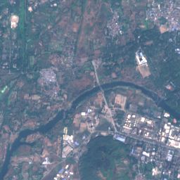

You can also read