Non-Forensic Databases for Interpretation of Forensic Soils - NIST
←
→
Page content transcription
If your browser does not render page correctly, please read the page content below
Non-Forensic Databases for
            Interpretation of Forensic Soils

                                          LIB BY STERN
                                           JODI WEBB
                                        MAUREEN BOTTRELL

                                           F B I L A B O R AT O R Y

                                                                      Some of these databases listed in this
                                                                      presentation have be used by the FBI
                                                                      Laboratory in aid of investigations, but most
Presented at 2016 NIST Workshop on Trace Evidence Data                have not. Reference to databases here does
July 20, 2016                                                         not represent endorsement by the FBI or DOJ.

                                                         1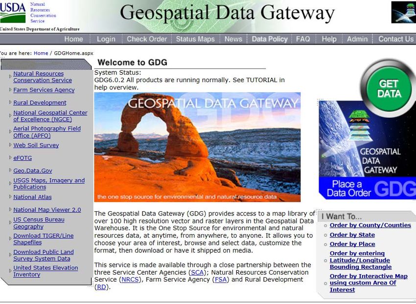
Outline
Background
Purposes of forensic soil examinations
Methods used in soil examinations
Databases of mineral occurrence and soil properties
Surficial and bedrock geology
USGS Geochemical and Mineralogical Maps for Soils of the
Conterminous United States
USDA soil databases
Examples of databases applied to recent cases
2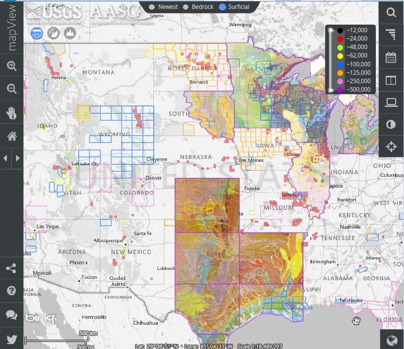
Goals of forensic soil/geology exams
Is this debris soil?
Is the soil at this (crime scene/alibi) location a
possible source of soil on the item (shoe, vehicle,
garment shovel….)?
Can specific locations be eliminated or identified as
possible sources of the soil?
What are the characteristics of the source location
based on characteristics of soil components
3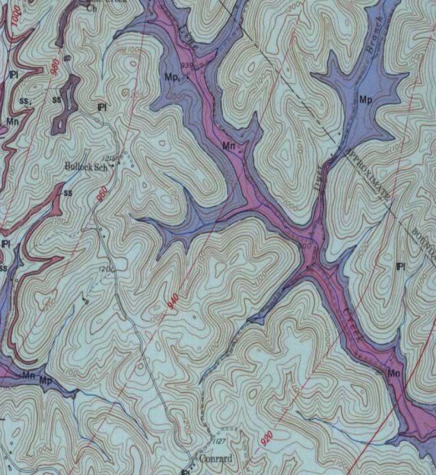
Methods for forensic soil characterization
Specialized Methods
Types of Methods Typical Methods
Mineral Chemical
Vary depending Reflected light microscopy characterization
on sample size, # of soil sources in sample Raman
condition and Aggregate size shape Spectroscopy
the case Grain coatings pH
circumstance Polarized light microscopy Microfossil ID
Non- or Mineral / Lithic fragment ID Geochronology
minimally- Grain size/shape/inclusions/surface texture
destructive Color
Powder XRD
Particle-based
Mineral ID (particularly for clay-sized particles)
observations
SEM
usually more
Surface texture, mineral ID
informative
4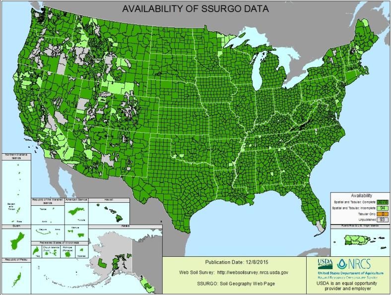
Excellent availability databases for mineral ID
PLM properties in books/web/apps
http://www.mindat.org/
MSA
http://www.handbookofmineralogy.org/Index.html
RRUFF - Mineral Raman Spectra + XRD
patterns
http://rruff.info/
Mineral Optical/IR spectral
http://minerals.gps.caltech.edu/FILES/Index.html
Power XRD patterns from ICDD (not free)
http://www.icdd.com/
Clay characterization
http://clays.org/SOURCE%20CLAYS/SCreferences.html
5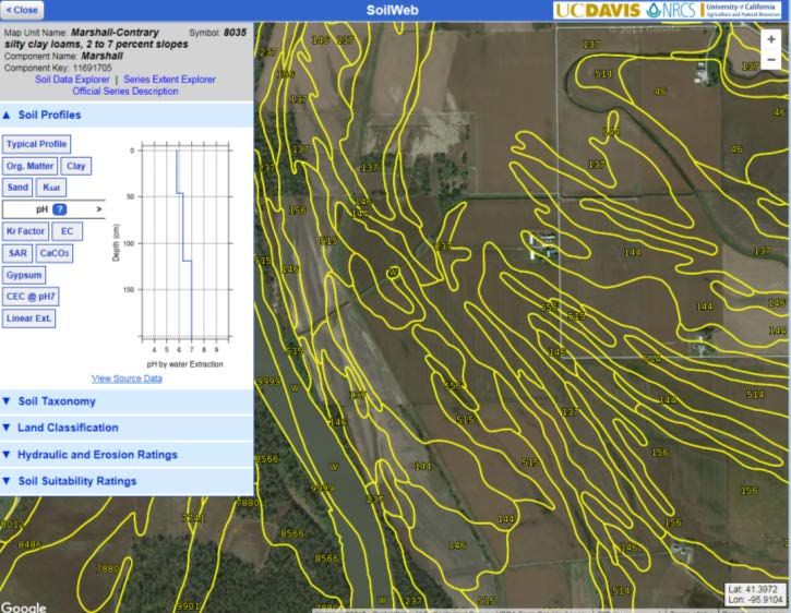
Need for databases of occurrence and soil properties
Minerals
Details of Crystal Chemistry (will always
be incomplete)
http://georoc.mpch-mainz.gwdg.de/georoc/
Rarity of Minerals / Known localities
(will always be incomplete)
Occurrence of surface features
Known environmental associations
Soil properties
Texture
Color (with some work)
Grain shape and surface texture
pH
Grain coatings
Krinsley &
Doornkamp 1973 Bull and Morgan 2006
6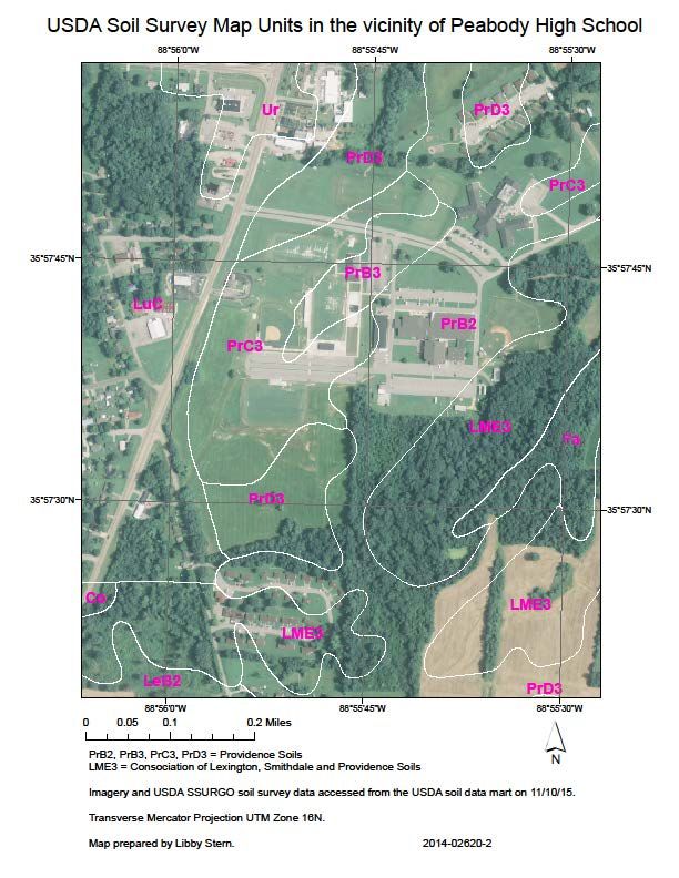
Re-appropriating existing databases: Geology

USGS Geologic Map Database
  http://ngmdb.usgs.gov/ngmdb/ngmdb_home.html
Association of American State Geologists (AASG)
   http://www.stategeologists.org/
  Some states do not include maps in the USGS
  database.

                                                7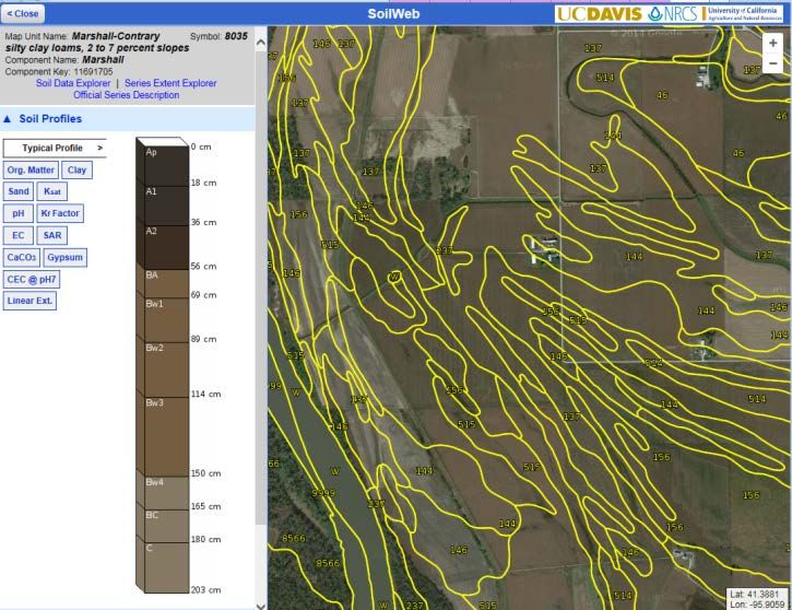
Surficial Geology / Quaternary Geology
Surficial Materials of
Conterminous U.S.
(USGS DS-425) 1:5,000,000
Maps from 1:12,000 to
1:500,000 from AASG and
NGMDB
Useful for:
Grain size distribution
Particle shape
Grain surface texture
(Mineral assemblage)
8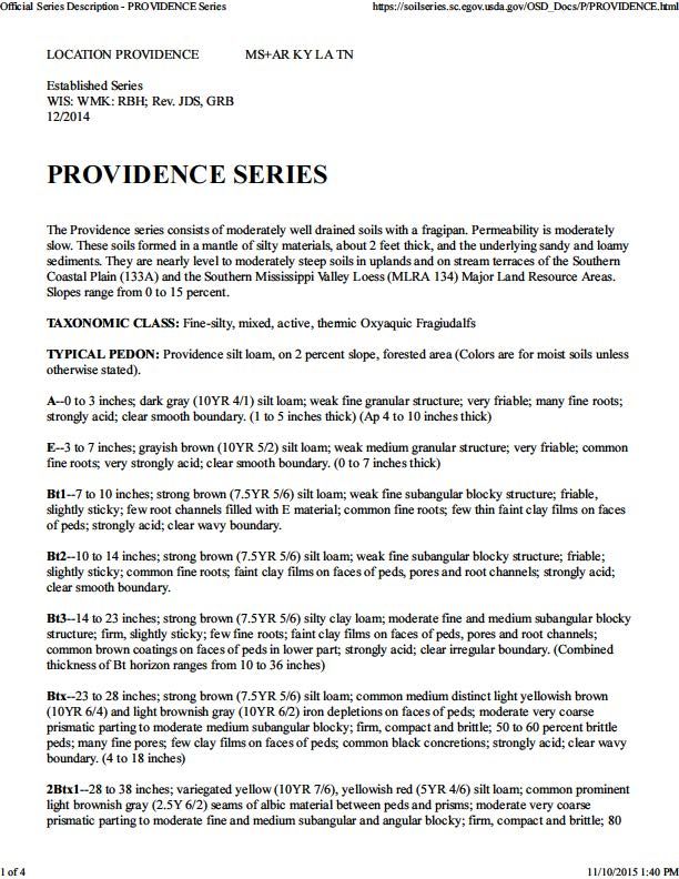
Bedrock Geology
Useful where bedrock is exposed 1:24,000 Bedrock Geology with
/ weathered in place / minimally detailed lithology description.
transported.
Useful for mineral content of soil
Availability / quality of maps for
forensic use is heterogeneous
maps are both scanned images
and GIS data
EXAMPLE
Title: Geology of the Billows quadrangle, Kentucky [A
digital rendition of this product is available]
Author(s): Hatch, N.L.
Publishing Organization: U.S. Geological Survey
Series and Number: Geologic Quadrangle Map GQ-
228
Publication Date: 1963
9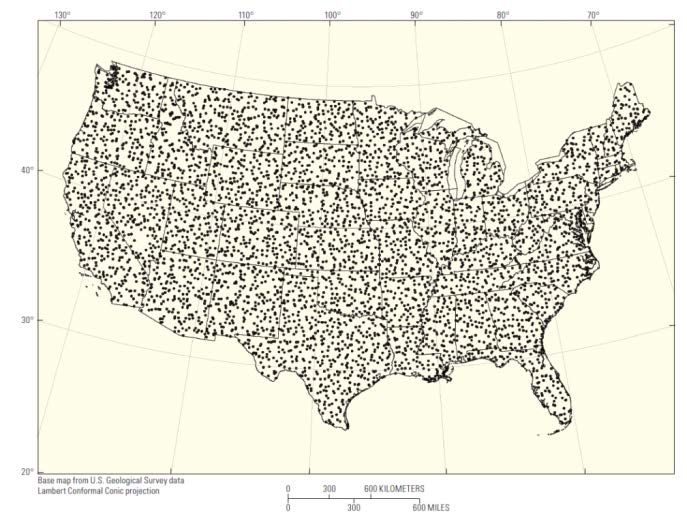
USGS Geochemical & Mineralogical Maps
for Soils of the Conterminous United States
Soil Data Series 801/Open-File
Report 2014–1082
http://pubs.usgs.gov/ds/801/
http://pubs.usgs.gov/of/2014/1082/
4,857 sites – Sieved to 80 cm
Quantitative powder XRD for
mineral characterization (A,C)
Elemental analysis 45 elements
(+orgC/inorgC) (surface, A, C)
Interpolation maps by Inverse
Distance Weighting (IDW)
1 site per 1,600 km2
Smith, D.B., Cannon, W.F., Woodruff, L.G., Solano, Federico, Kilburn, J.E., and Fey, D.L., 2013, Geochemical and mineralogical data for soils of the
conterminous United States: U.S. Geological Survey Data Series 801, 19 p., http://pubs.usgs.gov/ds/801/.
10USGS Geochemical & Mineralogical Maps
for Soils of the Conterminous United States
From USGS Open-File Report 2014–1082
11USGS Geochemical & Mineralogical Maps
for Soils of the Conterminous United States
Available both as
tabular/point data and
interpolated maps
From USGS Open-File Report 2014–1082
12USGS Geochemical & Mineralogical Maps for Soils of
the Conterminous United States
13
From USGS Open-File Report 2014–1082USGS Geochemical & Mineralogical Maps for
Soils of the Conterminous United States
Geochemical data are BULK
measurements
Soil are heterogeneous at
many scales
Forensic soils are from
unknown horizons From NBC/SNL
http://www.nrcs.usda.gov/wps/port
al/nrcs/detail/soils/edu/?cid=stelprd
b1236841
http://blogs.agu.org/terracentral/201
5/05/31/uncovering-a-soil-mystery-
using-micromorphology-and-
petrography/
14USGS Geochemical & Mineralogical Maps for
Soils of the Conterminous United States
Clays are largely controlled
by climate and landscape
age which tend to be
spatial continuous. (also
parent material)
From USGS Open-File Report 2014–1082
15USDA NRCS Soil Data (for forensic applications)
Soil Surveys
Historical printed county soil surveys
Soil spatial databases
STATSGO coarsely mapped at 1:250,000
gSSURGO mapped at a scale of 1:12,000 to 1:63,360
Official Soil Series Descriptions
https://soilseries.sc.egov.usda.gov/osdnamequery.asp
National Cooperative Soil Survey (NCSS) Soil
Characterization Database:
http://ncsslabdatamart.sc.egov.usda.gov/querypage.as
px
16NCSS Soil Characterization Database
(Pedon/Field Descriptions with Laboratory Data)
Lab
Report Forensically relevant characters:
pH, grain size distribution,
carbonates, gypsum, salts…
Minerals
Field Report
Parameters characterized vary from site-to-site 17USDA NRCS Soil Databases
Soil Survey Databases
STATSGO1:250,000
SSURGO 1:12,000 to 1:63,360
gSSURGO (SSURGO as 10 m
grid)
Similar Data Structure
18STATSGO/SSURGO Database Structure
Soil Survey Databases
STATSGO1:250,000
SSURGO 1:12,000 to 1:63,360
>60 tables in gSSURGO
Each table has 3 to 171 fields
19MUPOLYGON
STATSGO/gSSURGO MAPUNIT
Database Structure
MUAGGAT MAPUNIT
COMPONENT
COPMGRP
COPM
CHORIZON
20STATSGO/gSSURGO Database Structure
with some forensically relevant fields listed
MUAGGAT MAPUNIT MUPOLYGON
Brockdepmin=
Bedrock depth
minimum
Slopegraddcp COPMGRP
Slopegradwta= Pmgroupname =
Slope dominant COMPONENT Kind of deposit
/ weighted avg. and/or
Bedrock
CHORIZON
Hzdept_r = Horizon depth top
Hzdepb_r = Horizon depth bottom
Sandtotal_r, Silttotal_r, claytotal_r
= % Sand Silt Clay COPM
CaCO3_r = % CaCO3 PmKind =
Gypsum_r = % GypsumCaCO3 Kind of deposit
pH1to1H2O_r = pH 1:1 soil:water PmOrigin =
sar_r = sodium in soil water Bedrock
_r = representative value
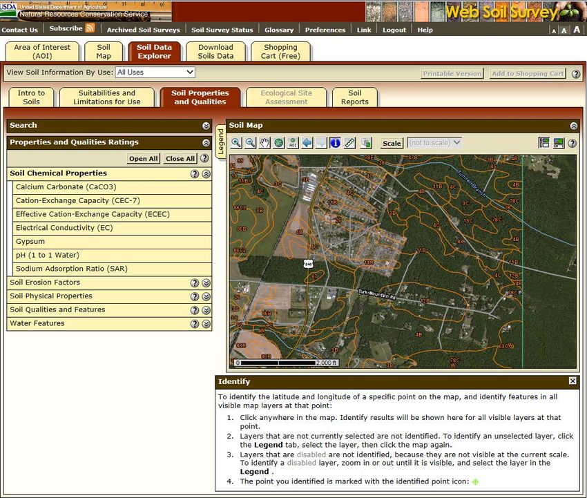
21Three ways access USDA soil survey data
Geospatial Data Gateway
https://gdg.sc.egov.usda.gov
Download geodatabase
county-, AOI-, state-level
(gSSURGO)
Best for use in GIS software
Web Soil Survey
Soil Web
22Three ways access USDA soil survey data
Geospatial Data
Gateway
Web Soil Survey
http://websoilsurvey.sc.egov.usda.gov/
App/WebSoilSurvey.aspx
specific parameters at
specific locations
Soil Web
23Three ways access USDA soil survey data
Geospatial Data Gateway
Web Soil Survey
SoilWeb
http://casoilresource.lawr.ucdavis.edu/gmap/
Specific parameters at specific
locations
Displays variations with depth
VERY easy to use
24What is this USDA soil survey data?
Map of “Map units”
1 or more “Components” comprise a map unit
Components correspond (usually) to “Official Soil
Series”
https://soilseries.sc.egov.usda.gov/osdname.aspx
Component A - 90% -- O.S.D.
Component B - 5%
Component C -5 %
25O.S.D.
Describes the
“typical” and
range of
properties of
this soil series.
Ranges of
properties
Color
Texture
+/- minerals
Parent material
Competing and
associated soils
26USDA Official Soil Series Descriptions + Soil Surveys
STRENGTHS (for forensics) WEAKNESSES (for forensics)
Numerous fields of interest Continuous data give the
for forensic geology exams appearance of ground truth
(ranges in color, pH, at all locations, but these
texture…+/- mineralogy) maps are interpolations /
Spatially continuous data interpretations
for nearly entire L48 states Color is NOT linked in the
Mapped very finely gSSURGO database
27Example 1 of soil survey data augmenting
reports of examination
Baseball field torn up by vehicle
Forensic soil comparison noted
similar (and unusual) soil
characteristics between crime
scene and soil from suspect’s
vehicle
USDA Soil survey maps and
Official Soil Series Descriptions
show that the natural soils of the
region have colors and textures
that are very distinct from the
artificial soil in the baseball
infield.
Adds to the weight of the evidence
by illustrating that the natural soils
in the region are very different
than the soil evidence
28Example2 of soil survey data augmenting
reports of examination
CASE SCENARIO PUBLISHED DATA SUBMITTED
AS SUPPORTING INFORMATION
Soil comparison case - Bedrock Geology
Could soil on evidence have been Soil Survey + O.S.D.
derived from crime scene? Published soil properties in
Only one comparison soil vicinity are mapped as similar
to the “known” exemplar
sample submitted submitted as evidence.
How spatially variable should the
soil properties be along road? Is
the “known” soil exemplar MAPPED SOIL AND GEOLOGY DATA
representative? WERE PRESENTED IN A DAUBERT
HEARNING. SOIL EVIDENCE WAS
JUDGED ADMISSIBLE.
Spatial heterogeneity within
~2000 m x 200 m area Permission to release case details was not approved in
advance of this presentation
29Example 3 of soil survey data augmenting
geographic attribution
Two possible source regions
– Upper Midwest versus
upper Great Plains.
Exact location unknown
Distinguishing might
corroborate or refute
statement
30Summary of use of non-forensic databases
for forensic soil examinations
No need for forensic investments in Soil, surficial geology and bedrock
databases of how to identify geology maps are interpretations /
minerals interpolations.
Databases of “typical” soil Useful for putting results of forensic
properties exist for most of the US. soil examinations in context.
Need to know how best to use USDA However, they cannot predict the
NRCS/NCSS data can to enhance EXACT characteristics at all locations
forensic soil examinations
Soil databases estimate the common
soil properties (pH, texture), but not
the unusual minerals or features,
which are most diagnostic in forensic
soil comparisons
Soil color is only indirectly linked to
databases
31You can also read