Urban Geospatial Data and Services on Bhuvan Geoportal

Page created by Elaine Foster
 
CONTINUE READING
Urban Geospatial Data and Services on Bhuvan Geoportal

                      Dr. K. Venugopala Rao
           Group Head, Urban Studies & Geoinformatics
             National Remote Sensing
                               Sensing Centre
                                        Centre (NRSC)
                                                (NRSC)
                      Dept. of Space , ISRO
                            Hyderabad

               India Geospatial Forum, Hyderabad
                         7th Feb, 2014
Urban Geospatial Data and Services on Bhuvan Geoportal
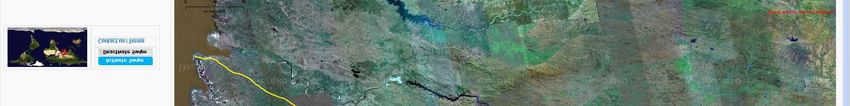
Presentation Contents

• Introduction: Relevance of Bhuvan for Urban
                Applications

• Bhuvan Data: Urban Geospatial Data Resources

• Bhuvan Applications : Master Plan Formulation

• Urban Science for Smart City Concept
Urban Geospatial Data and Services on Bhuvan Geoportal
Bhuvan          (www.bhuvan.nrsc.gov.in)

                                 Urban                       Rural
                                                             Rural

             Geo-portal of ISRO
  Visualization of Multi-resolution Images
       Free data download (NOEDA)
            Application Enabled
          Crowd Sourcing Enabled

                                        Public good Services
                                                    Services
                              Government Platform to Share the data
                              Platform to host dept/ user applications
Urban Geospatial Data and Services on Bhuvan Geoportal
Bhuvan 2D                       Bhuvan 3D                      Multi-resolution Satellite data

            Satellite Images
                                                                                     Cartosat-1
V                                                                                    Cartosat-2
                                                                               Resourcesat 1 - AWiFS
I                                                                              Resourcesat 1- LISS III
                                                                                Resourcesat 1 LISS IV
S                                                                                Oceansat-1- OCM
                                                                                 Oceansat-2- OCM
U
A   Mobile Bhuvan                                           Thematic Maps
                       Landuse Landcover- 1:50k , 2006-06                Geomorphology and Lineaments – 2005-06
L                      Landuse Landcover- 1:50k , 2011-12
                       Landuse Landcover- 1:250k, 2004- 05 to 2011-12
                                                                         Flood Annual Layers, Hazards
                                                                         NUIS 1:10,000 150 Towns
I                      Wastelands- 2008-09                               Natiowide 1:10,000 - Continuing

Z
A
T
I
O
N
Urban Geospatial Data and Services on Bhuvan Geoportal
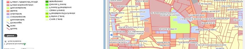
High Resolution Satellite data
Urban Geospatial Data and Services on Bhuvan Geoportal
Scope:
  •   Generation of Multi scale (10K,2K&1K) hierarchical Urban
      Geospatial database including thematic data for various
      levels of Urban Planning, Infrastructure development and
      e-governance using satellite, Aerial and GPR techniques.
  •   Total of 152 towns are covered for mapping under NUIS
      scheme.

Input data:
Cartosat-1 and LISS-IV MX satellite data, Collateral data from
Urban local bodies and other secondary sources

Database creation:
Thematic database of 12 primary layers of Base, Urban
Landuse, Geology/ Geomorphology and Soils along with 4
incorporated layers of administrative boundaries, forest
                                                                 Metro - 13 towns
boundaries, city/town boundaries, Settlement locations on
                                                                 Class I – 70 towns
1:10,000 scale.
                                                                 Class II – 15 towns
                                                                 Class III – 19 towns
                                                                 Class IV – 17 towns
                                                                 Class V – 6 towns
                                                                 Class VI – 12 towns
Urban Geospatial Data and Services on Bhuvan Geoportal
SNAPSHOTS OF NUIS DATABASE FOR TOWNS IN HARYANA STATE
                                                                  In Haryana, 5 towns were selected – Faridabad, Karnal, Panipat, Rohtak, Hisar.
                                                                  Out of the Five towns , Four are NCR towns.

                                                                  Town Name       Faridabad          Panipat       Rohtak     Karnal           Hissar

                                              Area mapped
                                                                                      468              311
                                                                                                       311           273
                                                                                                                     273        76
                                                                                                                                76              306
                                                                                                                                                306
                                                 (sq.km )

                                                                      Faridabad                                                      Panipat
On e 3 ’ x 3 ’ Maps h e e t (~ 2 8 s q.k m ) fo r e ac h t o wn

                                                                                                                                                   Public/ Semipublic

                                                                                                 Residential

                                                                                            Recreational
                                                                                                                                        Residential

                                                                            Industrial                             Kolar

                                                                                                      Public/ Semipublic

                                                                                                                                                                        Layouts
                                                                                                                                               Industrial
Urban Geospatial Data and Services on Bhuvan Geoportal
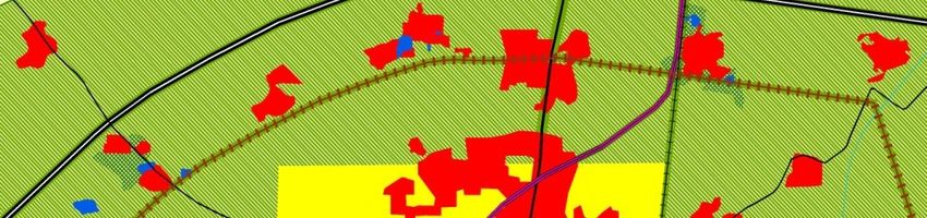
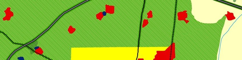
Large Scale (1:10,000 Scale) Urban Geospatial data for 152 Towns
Urban Geospatial Data and Services on Bhuvan Geoportal
Bhuvan NUIS: Preparation of urban plans by the
 Urban Local Body’s(ULB’s) using Bhuvan services.

Salient features-
        NRSC/ISRO has completed the preparation of 1:10000
        scale urban geo spatial database for 152 town under
        the National Urban Information System program.
        150 towns (Ministry of Defence cleared) urban
        database has been uploaded and available in Bhuvan
        NUIS citizen chapter as services.
        Bhuvan NUIS application has been developed to
        enable the respective ULB’s to use the NUIS for
        preparation of city/town Master plans.
        Bhuvan NUIS application is developed using open
        source technologies.
        With the initiative of Ministry of Urban Development
        (MoUD) NRSC/ISRO is organizing National level
        capacity building       program for Bhuvan NUIS
        application.

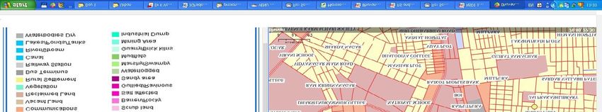
                                                       Bhuvan-National Urban Information System version 1.0.
NUIS -BHUVAN for City Developmental Plans (CDPs)
• For Urban Planners: National level single window Urban Geo-portal for Satellite imagery and geospatial
  data (creating, uploading existing data and updating ) for Urban planning / monitoring by the Urban
  Local Bodies in secured (User-ID and Password) environment.
• For Citizens: Geospatial data as maps & service
• Presently 2.5m NCC satellite imagery and MOD cleared 149 NUIStowns 10K geospatial data are available
• Govt. of AP has approved to upload 67 towns Master plans.

          Main Features                                     Database                                                                                    Open Source Technology
                                                            Server(Postgres+Postgis)

             Existing Data                                                                                                                          Creation and Updation
 NUIS and Town Specific databases
 Master plans                                                                                                                                       QGIS NUIS-Bhuvan
 Documents                                                      Authentication
                                                                                                                                                    • Single point data management.
                                                                                                                                                    • Client to Bhuvan server communication.
NUIS-Bhuvan Web Application                             Visualization                                                                               • Consuming of Bhuvan satellite services
 Status Updation                                                                                                                                      for change visualization in single click.
 Data versioning                                                                                                                                    • Data uploading from client end without
 Proper logging                                                                                                                                       browser based environment.
 Feedback                                                                                                                                           • Serving the uploaded data as web map

                                                                                                                ervices
                                                                                                               Services

                                                                                                                          Upload in Bhuvan server
 Citizen View                                                                                                                                         service.
 o Overlay of Master Plan.                                                                                                                          • Hierarchical user management and data

                                                                                                Consume Bhuvan S
 o Overlay of vector layers.                                                                                                                          versioning at server end.
 o Time series visualization.                                                                                                                       • Proper logging and data archival .
 o Feed back                                                                                                                                        • Modification of existing data at client
 Town specific View :Authentication to specific town     Internet                                                                                     end and updation at server end and
 o Junior Level Officer                                                                                                                               using Bhuvan web services.
       Create & Upload data(Raster and vector)                                                                                                      • Single point data management.
 o Second Level officer                                                                                                                             • Help module for Plug-in functionalities.
       Approve or Reject the data after visualization
       Status Update alert Massage                                                     ISRO Bhuvan Geo-portal
                                                                                                                                                    •   Multi-sensor time series satellite data.
       Secure Password on mobile
                                                                                                                                                    •   Satellite data Download;
 o Higher Level Officer
                                                                                                                                                    •   Thematic Services;
       Visualization
                                                                                                                                                    •   User response and discussions;
 State specific view :Authentication to all towns in
                                                                                                                                                    •   Terrain profile and other data and
 state
                                                                                                                                                        information services
 Nation al View: Authentication to state wise all          Internet users
 towns
NUIS-Bhuvan- QGIS
Satellite Data Visualization and Layer Tree

                                               Zoom to Layers Extents

Satellite
Pass Tree
List

                                                                              Satellite Pass Visualization

WEB APPLICATION FOR GAIL PIPEELINE SURVILLENCE AND MONITORING ON BHUVAN                                      NRSC,ISRO
Proposed Landuse – 2021   Proposed Landuse – 2021 (Revised)
RP 2021                              DRRP 2021
                          • Controlled area boundaries are revised.
                          • Urbanisable areas revised in Haryana &
                            Rajasthan.
                          • Major transport corridors like DFC, Orbital
                            rail, Regional transit systems, New rail links
                            are incorporated.
                          • Upgradation of major roads to NH /SH
                            proposed.

               Palwal

                                                                                                  Palwal

Proposed Landuse – 2021                                                      Proposed Landuse – 2021 (Revised)
Lakes in NCR in 1970,1999 , 2011 & 2012

                                                                                                                              Area in hectares

    Sub-Region                  Name of the Lake                         Description                  SOI TOPOSHEET (~1970)          1999                   2011                    2012

                                                                         Water extent                             53.19             38.79                   52.42                   54.84
                                     Bhalswa                           Area under Dry                              6.86                0                       0                         0
                                                                         Total Area                               60.05             38.79                   52.42                  54.84
     NCT-Delhi
                                                                         Water extent                                0                1.9                   11.38                   15.39
                                     Najafgarh                         Area under Dry                                0               1.42                    5.01                        0
                                                                         Total Area                                  0               3.33                   16.39                  15.39
                                                                         Water extent                            2209.32               0                   779.78                        0
                                        Kotla                          Area under Dry                                0             1597.33                 988.58                 1556.38
                                                                         Total Area                             2209.32           1597.33                 1768.36                 1556.38
                                                                         Water extent                             118.46             5.26                   46.18                   22.81
                                    Sultanpur                          Area under Dry                                0              60.43                   24.19                   41.19
                                                                         Total Area                              118.46             65.69                   70.37                        64
                                                                         Water extent                             115.96            58.97                   70.71                   41.29
                                    Damdama                            Area under Dry                                0               7.83                    8.23                   15.53
                                                                         Total Area                              115.96              66.8                   78.94                  56.82
      Haryana
                                                                         Water extent                              2.02               1.8                      0                         0
                                   Surajkhund                          Area under Dry                                0                 0                     2.56                    2.56
                                                                         Total Area                                2.02               1.8                   2.56                    2.56
                                                                         Water extent                             42.09             37.64                   11.31                        0
                                      Bhadkal                          Area under Dry                                0               2.25                   13.42                   28.97
                                                                         Total Area                               42.09             39.89                   24.73                  28.97
                                                                         Water extent                                0              434.04                 434.04                  434.04
                                    Bhidawas                           Area under Dry                                0                 0                       0                         0
                                                                         Total Area                                  0             434.04                  434.04                  434.04
                                                                         Water extent                             224.43            184.91                 275.36                  239.82
     Rajasthan                        Siliserh                         Area under Dry                                0                 0                     8.03                        0
                                                                         Total Area                              224.43            184.91                   283.4                  239.82
  Delineation done using visual interpretation from SOI Toposheet (~1970), LISS 3 (Mar - Apr 1999), LISS 3 (Oct 2011) &        RAINFALL DATA FOR NCR (source: IMD website):-
LISS IV (Mar- Apr 2012) satellite data.                                                                                        Avr. rainfall of 2mm in Mar-Apr 1999.
  The area is delineated as visible on the particular satellite image and Ground Truth for further verification, if            Avr. rainfall of 145mm in Sept. 2011 , Nil in Oct.2011.
required                                                                                                                       Avr. Rainfall of 1mm in Mar – Apr 2012.
Bhidawas Lake

SOI MAPSHEET                                     1999
               Field Photo –   10th   Dec,2012

                 SOI
                 1999
                 2011
                 2012

2011                                             2012
                                                 2012
Zonal Development Plan Zone "O" (River Yamuna / River Front) with Flood Events

In the O Zone layer, major recreational areas like
Commonwealth games and Public Utilities like
Gas power station, Transportation nodes like
MRTS terminial are present and are located in
areas flooded during 1988 & 2010 flood events.
Existing large scale map cover lay on Cartosat-2 ortho image and Updation

                                                                     Existing Bld.

                                                                            Updated with
                                                                            Cartosat-2
Factors Affecting Urban Heat Islands

 Geographic Location                                 Time          Synoptic Weather
 • Climate                                           • Day         • Wind ( Reduction in Wind Speed
 • Topography                                        • Season        varies, 54 % in Delhi, 59% in
                                                                     Mumbai, 37% in Kolkata ,30% in
 • Rural Surroundings                                                Chennai, 58% in Bangalore, 23%
                                                                     in Nagpur, De U.S, et, al., 2009)

                                                                   • Cloud ( Increased rain trend in
                                                                     many Indian Cities 14 to 4%, De
                                                                     U.S, et, al., 2009)
                                                         UHI
City Size
• Linked to form &
  function                                                      City Form
 MCH (220 sq.km to GHMC (2000
 sq.km) HUDA has increased to
                                                                • Materials
 2000 sq.km to 6000 sq.km                                       • Geometry
 By 2050, it is projected that more                             • Green space
 than 50% of the people will live
 in Urban areas in India, De U.S, et   City Functions
 al, 2009
                                       •Energy Use
                                       •Water Use
                                       •Pollution
Influence of Urbanization on Urban Heat Island
                                   From Space Based Multi Sensor Data

       Surat – Change in Settlement Area

                                                                                  1. Dense Built-up

   A

             1
                  2
                                                       1
                       3                                       2                  2. Open Space
                                                                          3
                        B

                                         A                                    B
32.960 C          17.930 C
                 Surat City LST(K) from ASTER Data 5th April 2005 Night

                                                                                      3. Rural
Urban Micro-Climate

Geospatial    information    on    urban               • Proof of concept for Micro - level modelling
morphology to facilitate understanding of                (using Envi-Met model) based on urban
urban heat islands and providing urban                   morphology to derive the 2D and 3D
advisories towards sustainable habitat                   parameters such as temperature, wind
                                                         patterns, short & long-wave radiation
                                                         vectors for UHI computation has been done
                                                         for two test sites in Delhi.

                             Model Inputs:
                             Model  Inputs:
                             1. Grid based Micro
                                Urban morphology
                                (Urban structures
                                planimetry and
                                height, vegetation
                                and surface type                                     Wind direction
                                parameters, …)
                             2. AWS parameters at
                                Simulation.
                                Initialization time.

                              3D and non-
                              hydrostatic
                                                        • M
                                                          Micro
                                                            icro urban morphology overlaid on S Simulated
                                                                                                 imulated 3D
                              microclimate model
                              based on
                                                          temperature profile at 5m height.
                              fundamental laws of       • Date: 20.05.2009; Time: 18.30 hrs (Model can simulate
                              fluid and thermo            for 6 to 24 hrs and can derive output parameters at
                              dynamics.                   hourly basis).

                                                                 Temperature below 303.91 K           Temperature above 305.08 K
Building Rooftop area in %
Vacant area in %
Pilot Study area
Part of Nanakpura –
     New Delhi
Wind Direction
                                                                Wind Direction

Existing Urban Setup in 40 X 40 Grid   3D Temperature Profile
       (number represent height)
Wind Direction

                               Grass
                               Trees
                               Trees

Additional Trees & grass added in the Model   Simulated 3D Temperature Profile
3D Temperature Profile at 5m Height
Wind Direction
Long wave Radiation
Conclusions

• Urban Planning and applications require multi-scale scientific geospatial data
  Remote Sensing data is excellent, cost effective source for creating / updating
  cartographic data base.

• Mobile Ground based attribute collections is useful way to integrate spatial &
  attribute data in near real time.

• NRSC/ISRO & TCPO/MoUD working towards operationalzation of Bhuvan platform
  to meet the ULBs Geospatial needs.
Thank you
You can also read