Pré-Michel nature trail - Abriès-Ristolas - Chemins des parcs
←
→
Page content transcription
If your browser does not render page correctly, please read the page content below
PNR Queyras
                                                                                                             In partnership with
                                                                                               OTI du Guillestrois et du Queyras

Pré-Michel nature trail
Abriès-Ristolas

Anemone (Alain Bloc - PNR Queyras)

Years ago, the landscape was very                                             Useful information
different; tomorrow it will have                                              Practice : WALKING
changed again. How can we preserve
the natural resources that make up this                                       Duration : 2 h
landscape today?                                                              Length : 2.4 km
Under the watchful eye of Mont Viso, Pré-Michel, evidence
a by-gone agricultural, is constantly changing. The species                   Trek ascent : 182 m
that were favoured by human exploitation, are now facing
competition. Species formerly kept at bay by harvesting the                   Difficulty : Very easy
hay start to colonize the area. This transition offers                        Type : Boucle
exceptional diversity.
                                                                              Themes : Farming and pastoralism,
                                                                              Flora

                                       10/07/2021 • Pré-Michel nature trail                                                 1/9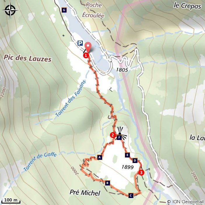
Trek

Departure : La Roche écroulée, left side of the Guil River
Arrival : La Roche écroulée
Markings : PR

From the car park of Roche écroulée, return to the road, climb 50 metres and turn right onto a good
grassy path. Follow the slight uphill stretch up into a larch forest. The start of the Pré-Michel nature trail is
600m away. Climb through the forest to reach Pré-Michel (viewpoint on Mont Viso). You can see Mont
Viso in all its glory (3,841m). After a few metres, climb to the right among the tall grass. You can enjoy the
wealth of flora in this area. Turn left onto a flat bumpy trail. You will arrive at a crossroads. On the right, a
small circular path takes you back 200m (you don’t have to do this very short circuit). Turn left and
descend on an even path. You will come to an opening in the forest that offers a second view of Mont
Viso. Turn left and follow a flat path, which returns to Pré-Michel. From there, take the path that you
started out on.

                                           10/07/2021 • Pré-Michel nature trail                                2/9
On your path...
Mountain Circium (A) The Aspen (B)
Black woodpecker (C) Agricultural decline (D)
Anemone narcissiflora (E) Viewpoint on Viso (F)
La Roche écroulée (G)
10/07/2021 • Pré-Michel nature trail 3/9All useful information
Advices
You enter the Ristolas Mont Viso nature reserve. Special regulations apply here. For more information
go to: http://www.pnr-queyras.fr/protection-et-gestion-du-patrimoine-naturel-et-culturel/item/68-
r%C3%A9serve-naturelle-nationale-mont-viso-ristolas
Altimetric profile
Min elevation 1799 m
Max elevation 1979 m
Transports Access
Information: 05 Voyageur 04 92 502 505 or www. Pass L’Echalp and continue on the D947 road to La
05voyageur.com / Queyras Tourist Office Roche écroulée car park.
Advised parking
La Roche Ecroulée
10/07/2021 • Pré-Michel nature trail 4/9Information desks
House of the Queyras Regional Nature Park
La ville, 05350 Arvieux
pnrq@pnr-queyras.fr
Tel : +33 (0)4 92 46 88 20
http://www.pnr-queyras.fr/
OTI du Guillestrois et du Queyras
Maison du Tourisme du Queyras, 05350 Château-Ville-Vieille
info@guillestroisqueyras.com
Tel : +33 (0)4 92 46 76 18
http://www.guillestroisqueyras.com
10/07/2021 • Pré-Michel nature trail 5/9On your path...
Mountain Circium (A)
This circium grows in the subalpine zone. Like all Asteraceae, its particularity is
to be composed of a multitude of small flowers close to each other (the most
famous Asteraceae is probably the daisy). This plant is nationally protected. In
the Hautes Alpes, it can only be found on the lower slopes of Queyras.
Attribution : Alain Bloc - PNR Queyras
The Aspen (B)
The leaves of the aspen have the characteristic of twirling in the slightest
breeze. It is this feature that earned it its name. It loves the light and colonizes
clearings, cuttings and forest edges. The abandonment of agriculture in Pré-
Michel was a blessing for this tree, which is gradually spreading. For the species
already present, its arrival is a calamity. Indeed, the shade it brings causes the
disappearance of many meadow flowers.
Black woodpecker (C)
The largest of all woodpeckers (45cm), it is a solitary bird. It feeds on plants,
insect borers and ants. Hyperactive, it is always moving. It goes from one tree
to another in an irregular and powerful flight. Its beak allows it to pierce tree
trunks to search for food or to create holes in which it can nest. Once
abandoned, the nests are used by chickadees, Boreal owls, martens, bees, etc.
Attribution : Jean-Baptiste Portier - PNR Queyras
Agricultural decline (D)
In 1850, Queyras was at its peak with a population of 8,500 inhabitants.
Agriculture was present everywhere. Part of the forest has been cleared for
pasture or hay fields. This type of agriculture has enabled a particular type of
flora to grow. Changing lifestyles, the development of industry in cities, two
world wars and changing agricultural practices decimated the population. In
1970, only 1,900 inhabitants still lived in Queyras. The least accessible plots are
abandoned and the forest takes over.
Attribution : DR
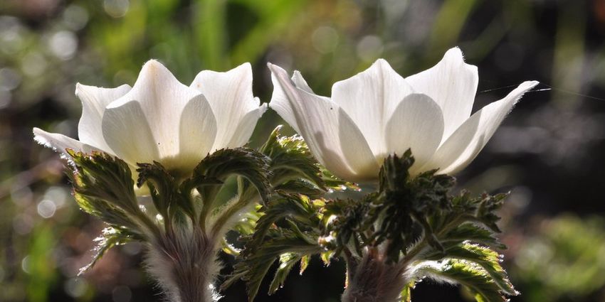
10/07/2021 • Pré-Michel nature trail 6/9Anemone narcissiflora (E)
The Anemone narcissiflora is found in meadows, pastures and on the edges of
limestone cliffs. It is characterized by its beautiful white flowers grouped in
umbels.
Attribution : Alain Bloc - PNR Queyras
Viewpoint on Viso (F)
So close yet so far away. From here Mont Viso appears to be a few steps away
and yet it would take many hours for even the bravest to reach it.
Attribution : Benjamin Musella - PNR Queyras
La Roche écroulée (G)
At the end of the 19th century, in the Haut Guil area, the mountain rumbled. A
succession of cracking sounds and screams were heard. A dust cloud appeared
in the distance. Some thought it was an earthquake. In the following days, the
local inhabitants went to a place called ‘lou pas des maisons’ and had a major
surprise: part of the Pic des Lauzes had collapsed and millions of tons of rocks
covered the hay fields. La Roche écroulée is the result of this event.
10/07/2021 • Pré-Michel nature trail 7/9• En aucun cas les auteurs des contenus de ce site ne sauraient être tenus pour responsables de
problèmes ou d'accidents sur les itinéraires cités.
• Cependant, nous comptons sur vous pour signaler toutes contradictions importantes entre cette
fiche et le terrain.
• Pensez également à signaler les éventuels problèmes rencontrés pendant votre balade sur http://
sentinelles.sportsdenature.fr (erreur de balisage, panneau défectueux, pollution, conflit d'usages…).
• La vente de cette fiche est autorisée au coût d'impression.
• Ne pas jeter dans la nature.
L'outil Geotrek a été financé par l'Union européenne, le Parc national des Ecrins et le Parc national du
Mercantour.
Le projet Chemins des Parcs est financé par la Région Provence-Alpes-Côte-d'Azur et les Parcs naturels
régionaux des Alpilles, de Camargue, du Luberon, du Queyras et du Verdon.
Ce projet partenarial rassemble également le Comité Régional du Tourisme, les agences départementales
de développement touristique, les offices de tourisme et les syndicats d'initiative.
• The authors of this website will in no case be held responsible for problems or accidents on the
routes mentioned.
• We count on you to point out any inconsistency between this content and the field itineraries
• Please report any problems encountered on the routes (route marking problems, defective panels,
pollution, conflict of uses ...) on http://sentinelles.sportsdenature.fr
• The sale of this sheet is authorized at the cost of printing
• Please don’t litter
The Geotrek tool was funded by the European Union, the Ecrins National Park and the Mercantour
National Park.
The Chemins des Parcs project is funded by the Provence-Alpes-Côte-d'Azur Region and the regional
nature parks of Alpilles, Camargue, Luberon, Queyras and the Verdon.
This project was developed in partnership with the Regional Tourism Committee, the departmental tourist
development agencies, and tourist offices.
10/07/2021 • Pré-Michel nature trail 8/9Avec le soutien de
10/07/2021 • Pré-Michel nature trail 9/9You can also read