The Botanical Trail Esparron-de-Verdon - Chemins des parcs
←
→
Page content transcription
If your browser does not render page correctly, please read the page content below
PNR Verdon
In partnership with
OT Gréoux-les-Bains
OTI Durance-Luberon-Verdon
The Botanical Trail
Esparron-de-Verdon
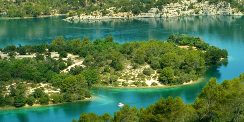
Depuis le sentier botanique (Stefano Blanc - PNR Verdon)
I love this rich and pleasant stroll Useful information
throughout the year taking advantage Practice : WALKING
of the landscapes especially in spring
with the maximum flowering. Duration : 3 h
Take time to discover the various facets of vegetation. Length : 6.0 km
Throughout the route you will find signs naming the main Trek ascent : 204 m
species of trees and shrubs. Be careful and enjoy them
without damaging, please do not pick them, such seemingly Difficulty : Easy
common species can be rare and protected. This is the case
Type : Boucle
of the fritillaria here present, which is found only in the
Southern Alps. A beautiful photo lasts longer. Stefano Blanc Themes : A lookout, a viewpoint, Flora,
Ecogarde at the PNR Verdon. Heritage and history
10/12/2021 • The Botanical Trail 1/9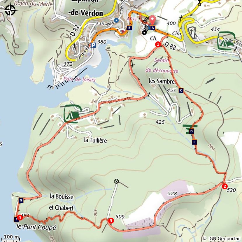
Trek

Departure : From the village center
Arrival : To the village center
Markings : PR GR®

From the car park of the tourist office, get on the D82 road and turn right towards the castle and its
fountain. Turn right in 100m at the intersection between the roads of La Tuilière and Quinson.

1- Take the right route (Lake Road and Tuilière Road). After 50m on the Chemin de Tuilière, turn left onto
the GR discovery trail (red and white markings). The entire climb, on a trail, is common with this special
course. Pass in front of the viewpoint of the Tuilière. Cross a small valley and reach, to the top, a
crossroads of tracks at a place known as Séouve.

2- At the crossroad turn right (yellow signs) and follow "pont coupé 1.5km"

3- Leave the trail that leads to the relay and take the path on the left, follow the trail. (Careful, the descent
to the lake is a bit abrupt!)

4- At the bottom of the road turn right and join the paved road Chemin de Tuiliére, follow it to point 1.
Continue on the same route as before.

                                            10/12/2021 • The Botanical Trail                                  2/9
On your path...
The Baron's dungeon (A) Once upon a time, Vière... (B)
Esparron, the small medieval lock (C) The Viewpoint Indicator Map (D)
The Phoenician Juniper or Mourven Le Pont Coupé (F)
Provencal (E)
Lake of Esparron (G)
10/12/2021 • The Botanical Trail 3/9All useful information
Advices
We recommend at least 2L / 34 OZ of water per person, a hat and proper walking shoes. Avoid trail
during hot weather. Find out before, the forests are sometimes closed in the summer due to fire risk.
The town of Esparron de Verdon had two major fires in 2003 and 2005, BE CAREFUL! FIRE CAN START
VERY QUICKLY. (As a reminder, smoking in forests is prohibited).
Altimetric profile
Min elevation 363 m
Max elevation 524 m
Transports Access
Limitons les déplacements en voiture, pensons 12km east of Greoux-les-Bains on the D952,
aux transports en commun et au covoiturage. D315, and D82
Tous les transports en commun sur
www.pacamobilite.fr
Advised parking
Car park below the village
10/12/2021 • The Botanical Trail 4/9Information desks
House of the Verdon Regional Nature Park
Domaine de Valx, 04360 Moustiers-Sainte-Marie
info@parcduverdon.fr
Tel : +33 (0)4 92 74 68 00
http://www.parcduverdon.fr/
OT Gréoux-les-Bains
7 place de l'hôtel de ville, 04800 Gréoux-les-Bains
greouxlesbains@tourisme-dlva.fr
Tel : +33 (0)4 92 78 01 08
http://www.greoux-les-bains.com/greoux-les-bains/fr/40/office-de-
tourisme.html
OTI Durance-Luberon-Verdon
http://www.durance-luberon-verdon.com
10/12/2021 • The Botanical Trail 5/9On your path...
The Baron's dungeon (A)
The memory of Boniface VI of Castellane, a fierce baron and impetuous
troubadour who lived in the 13th century, still hangs over Esparron-de-Verdon,
and more particularly in the renowned dungeon of his castle. Because this
mighty building with its massive battlements reflects the ardour of Boniface,
who challenged the new Count of Provence, Charles of Anjou, whom he called
scornfully "franciot" (little Frenchman).
Attribution : Stefano Blanc - PNR Verdon
Once upon a time, Vière... (B)
Located below the castle of Esparron-de-Verdon, the Vière area, historic heart
of the village, did not resist the rural exodus and was abandoned by its
inhabitants. It is now in ruins, nature has reasserted itself. After rehabilitation,
the site is revived and is now accessible, secured and landscaped. This is an
area for strolls, between vegetation and ruins, their stones being a
remembrance, which offers magnificent views of the village and the lake.
Attribution : Stefano Blanc - PNR Verdon
Esparron, the small medieval lock (C)
It was easy to cross Verdon to Esparron, the waters were calmer at the mouth
of the lower gorges. A bridge, nowadays submerged by the waters of the lake,
was built there in 1725. The village had therefore define an important route
between Var and Haute-Provence. Its function itself is specified in its name.
The medieval "Espar" is a lock. And what is this town locking? The great path,
which of course, it is carefully monitoring at this period.
Attribution : DR
The Viewpoint Indicator Map (D)
The viewpoint indicator map located 498m high provides views of the lake and
the port of the town of Esparron du Verdon. In the distance, we can see the
massif of Luberon and the Lure mountain
Attribution : Stefano Blanc - PNR Verdon
10/12/2021 • The Botanical Trail 6/9The Phoenician Juniper or Mourven Provencal (E)
It is the second Mediterranean juniper that immediately differs from its cousin,
the Cade, by its innumerable ramules covered with tiny tortoiseshell leaves. Its
range is also less extensive. Very xerophile, he likes the poorest scrubland,
cracks of rocks and even limestone cliffs where his red brick balls defy the most
insane sunshine and aridity almost absolute.
Attribution : Stefano Blanc - PNR Verdon
Le Pont Coupé (F)
Here the small road seems to flow into the lake. It has not always been the
case. In 1967, the water filling of the lake submerged on12m a stone bridge
with three arches spanning the Verdon that connected "Le Quartier” to the rest
of the town of Esparron. Passing between the Var and the Alpes de Haute
Provence. The bridge built in 1725 by the town council of Arles was a
passageway for sheep transhumance between La Crau and the Pre-Alps
pastures thus avoiding the unpredictable Verdon.
Attribution : DR
Lake of Esparron (G)
Lake of Esparron, with its 85,000,000m³ has an area of 328ha for a maximum
depth of 55m, is used to supply water to a hundred towns of the Var and
Bouches du Rhone from Marseille to Toulon. The old canal of the Verdon is
visible from the nature trail at the entrance of the gorges. It was built under
Napoléon III and provided water supply from the Basse-Provence at that time.
A lake in which it is pleasant to bathe in summer.
Attribution : Stefano Blanc - PNR Verdon
10/12/2021 • The Botanical Trail 7/9• En aucun cas les auteurs des contenus de ce site ne sauraient être tenus pour responsables de
problèmes ou d'accidents sur les itinéraires cités.
• Cependant, nous comptons sur vous pour signaler toutes contradictions importantes entre cette
fiche et le terrain.
• Pensez également à signaler les éventuels problèmes rencontrés pendant votre balade sur http://
sentinelles.sportsdenature.fr (erreur de balisage, panneau défectueux, pollution, conflit d'usages…).
• La vente de cette fiche est autorisée au coût d'impression.
• Ne pas jeter dans la nature.
L'outil Geotrek a été financé par l'Union européenne, le Parc national des Ecrins et le Parc national du
Mercantour.
Le projet Chemins des Parcs est financé par la Région Provence-Alpes-Côte-d'Azur et les Parcs naturels
régionaux des Alpilles, de Camargue, du Luberon, du Queyras et du Verdon.
Ce projet partenarial rassemble également le Comité Régional du Tourisme, les agences départementales
de développement touristique, les offices de tourisme et les syndicats d'initiative.
• The authors of this website will in no case be held responsible for problems or accidents on the
routes mentioned.
• We count on you to point out any inconsistency between this content and the field itineraries
• Please report any problems encountered on the routes (route marking problems, defective panels,
pollution, conflict of uses ...) on http://sentinelles.sportsdenature.fr
• The sale of this sheet is authorized at the cost of printing
• Please don’t litter
The Geotrek tool was funded by the European Union, the Ecrins National Park and the Mercantour
National Park.
The Chemins des Parcs project is funded by the Provence-Alpes-Côte-d'Azur Region and the regional
nature parks of Alpilles, Camargue, Luberon, Queyras and the Verdon.
This project was developed in partnership with the Regional Tourism Committee, the departmental tourist
development agencies, and tourist offices.
10/12/2021 • The Botanical Trail 8/9Avec le soutien de
10/12/2021 • The Botanical Trail 9/9You can also read