Col Lacroix Abriès-Ristolas - Chemins des parcs
←
→
Page content transcription
If your browser does not render page correctly, please read the page content below

PNR Queyras
                                                                                                       In partnership with
                                                                                         OTI du Guillestrois et du Queyras

Col Lacroix
Abriès-Ristolas

Ristolas (Benjamin Musella - PNR Queyras)

This hike, by the lower mountain pass                                   Useful information
for Italy, walks you through a forest                                   Practice : WALKING
with trees of over 500 years and views
on the top of the Guil and Val Pellice.                                 Duration : 4 h

An important crossing and privileged exchanges with the Val             Length : 8.6 km
Pellice. Discover the ruins of the refuge of Napoleon III,              Trek ascent : 638 m
indicative of the importance of existing cross-border
relations through this pass. You will go through an old forest          Difficulty : Medium
where you will see remarkable trees of over 500 years.
                                                                        Type : Boucle

                                                                        Themes : A lookout, a viewpoint,
                                                                        Heritage and history

                                             11/01/2021 • Col Lacroix                                                 1/8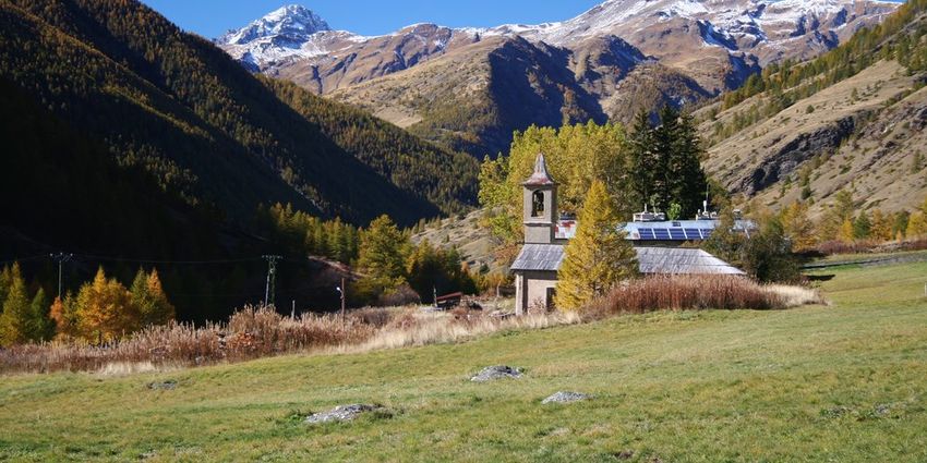
Trek

Departure : La Monta
Arrival : La monta
Markings : GR®

From the car park, go up the road for about 100m and turn left onto a track. Climb for 400m and take the
path on the right.
1 - Cross a river, enter the forest and get on the winding path. The path continues on the right and
overlooks the stream of Combe Morelle. Follow on level a trail a bit airy. Continue in the valley and in
turns, leave behind a sheep pen and the Napoleon refuge on the left. Continue until Col Lacroix Start the
descent on the same path used to ascend.
2 - After 50m, take the left path. Cross the stream and follow the valley. Enter the larch forest and after a
short delicate passage, follow the same path on the left. Continue downhill through the forest to reach
Echalp.
3 - Descend the road and reach the car park from the starting point.

                                              11/01/2021 • Col Lacroix                                     2/8
On your path...
Eurasian blue tit (A) The Upper Guil (B)
Napoleon refuge (C) Col Lacroix (D)
The Larch (E) La Monta hamlet (F)
11/01/2021 • Col Lacroix 3/8All useful information
Altimetric profile
Min elevation 1666 m
Max elevation 2304 m
Transports Access
05 Voyageur: 04 92 502 505 Tourist Office of Follow the D947 to La Monta.
Queyras: 04 92 46 76 18
Advised parking
La Monta
Information desks
House of the Queyras Regional Nature Park
La ville, 05350 Arvieux
pnrq@pnr-queyras.fr
Tel : +33 (0)4 92 46 88 20
http://www.pnr-queyras.fr/
OTI du Guillestrois et du Queyras
Maison du Tourisme du Queyras, 05350 Château-Ville-Vieille
info@guillestroisqueyras.com
Tel : +33 (0)4 92 46 76 18
http://www.guillestroisqueyras.com
11/01/2021 • Col Lacroix 4/8On your path...
Eurasian blue tit (A)
Hanging on top of a tree or a twig, the Eurasian blue tit eats small insects,
larvae, caterpillars, spiders and invertebrates. Once the branch is cleaned, the
Eurasian blue tit moves on to the next one. Occasionally, it can eat fruits and
seeds. The female nests in holes of trees or walls. It broods 7 to 13 eggs for 15
days while the male feeds. The chicks will be entirely dependent on their
parents their first month of life.
Attribution : Benjamin Musella - PNR Queyras
The Upper Guil (B)
View on the upper valley of the Guil from the slope.
Attribution : Benjamin Musella - PNR Queyras
Napoleon refuge (C)
In his will, Napoleon I left half of his estate in Alsace, Bourgogne, Ile de France,
Champagne, Forez and Dauphiné, in restitution for the invasions suffered. 34
years later, Napoleon III has a committee interpret the will of his uncle which
distributes the funds. 26 departments including the Hautes-Alpes are granted
the sum of 50,000 francs. This sum was initially intended to help the deaf and
blind of the department but few requests were made. The money is eventually
used to build six shelters on the main passes of the department.
Attribution : Benjamin Musella - PNR Queyras
Col Lacroix (D)
In the Middle Ages, the upper Guil passes allowed numerous exchanges
between the Queyras and Italy. The inhabitants of Queyras practised
transhumance in the fall to Italy and took the opportunity to sell cheese and
meat. In the 13th century, a French-Italian market existed in Abriès. Many
Italian merchants came to trade there. In the 16th century, persecuted
throughout the Italian Piedmont valleys, hundreds of Waldensians (Followers
of the christian movement founded by Peter Waldo) travel these mountain
passes to find refuge in the Queyras before having to migrate again a century
later. They played an important role in the establishment of Protestantism in
the Queyras.
Attribution : Benjamin Musella - PNR Queyras
11/01/2021 • Col Lacroix 5/8The Larch (E)
Originally from the Alps and the Carpathians, the larch is the only conifer to
lose its needles in winter and to bear this red colour in the fall. By falling, the
needles enrich the soil and encourage the arrival of new species. With its
powerful roots and flexibility of its branches and trunk, it settles in the
deforested areas without fearing avalanches. The Praroussin forest embraces
many individuals over 500 years old.
Attribution : Benjamin Musella - PNR Queyras
La Monta hamlet (F)
The name of this hamlet stems from the fact that it is the starting point of the
climb to the Col de la Croix. Formerly populated and active, the hamlet suffered
multiple damages throughout history. Various avalanches that devastated the
place, the one in 1885 being the most damaging, destroying 12 houses. In
1944, it was German troops that set the town on fire. The flood of 1957 left
only two buildings that still exist today: the cottage and the Saint Laurent
chapel.
Attribution : Benjamin Musella - PNR Queyras
11/01/2021 • Col Lacroix 6/8• En aucun cas les auteurs des contenus de ce site ne sauraient être tenus pour responsables de
problèmes ou d'accidents sur les itinéraires cités.
• Cependant, nous comptons sur vous pour signaler toutes contradictions importantes entre cette
fiche et le terrain.
• Pensez également à signaler les éventuels problèmes rencontrés pendant votre balade sur http://
sentinelles.sportsdenature.fr (erreur de balisage, panneau défectueux, pollution, conflit d'usages…).
• La vente de cette fiche est autorisée au coût d'impression.
• Ne pas jeter dans la nature.
L'outil Geotrek a été financé par l'Union européenne, le Parc national des Ecrins et le Parc national du
Mercantour.
Le projet Chemins des Parcs est financé par la Région Provence-Alpes-Côte-d'Azur et les Parcs naturels
régionaux des Alpilles, de Camargue, du Luberon, du Queyras et du Verdon.
Ce projet partenarial rassemble également le Comité Régional du Tourisme, les agences départementales
de développement touristique, les offices de tourisme et les syndicats d'initiative.
• The authors of this website will in no case be held responsible for problems or accidents on the
routes mentioned.
• We count on you to point out any inconsistency between this content and the field itineraries
• Please report any problems encountered on the routes (route marking problems, defective panels,
pollution, conflict of uses ...) on http://sentinelles.sportsdenature.fr
• The sale of this sheet is authorized at the cost of printing
• Please don’t litter
The Geotrek tool was funded by the European Union, the Ecrins National Park and the Mercantour
National Park.
The Chemins des Parcs project is funded by the Provence-Alpes-Côte-d'Azur Region and the regional
nature parks of Alpilles, Camargue, Luberon, Queyras and the Verdon.
This project was developed in partnership with the Regional Tourism Committee, the departmental tourist
development agencies, and tourist offices.
11/01/2021 • Col Lacroix 7/8Avec le soutien de
11/01/2021 • Col Lacroix 8/8You can also read