Walking the Drover's road around Amersham
←
→
Page content transcription
If your browser does not render page correctly, please read the page content below
Walking the Drover’s road around Amersham
Amersham was near a cross roads of two important drovers’ routes. The ever
expanding population of London needed feeding and the driving of live animals
across the country into London had been going on in the Middle Ages and into the
sixteenth, seventeenth and eighteen centuries until the railways enabled the
transport of livestock on wheels.
It’s obvious that the gap in the Chilterns at Wendover would make the Misbourne
Valley an important route into London from the Midlands. What I had not realised
was that there was another important route from mid-Wales to Barnet which crossed
the river Misbourne just downstream from Amersham.
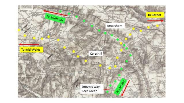
Detail of a map copied from The Drovers by Shirley Toulson, Shire Press 2011
This circular walk - about 12 miles - follows stretches of both these routes with a
connection which probably formed a local drove route between Little Missenden
village and Wycombe Heath common.
Except at natural (or man-made) pinch-points these drove routes would be very
wide and would become even wider in winter as travellers, including drovers,
avoided the boggiest stretches. As droving died out some of the route became
roads, with metalled tar mac surfaces only after the popularity of motor cars in the
early twentieth century, others became tracks and others were maintained as rights
of way, either as bridleways or footpaths. This walk follows all of these.Start in Amersham High Street. We usually say that the width of the street was to allow the
twice yearly fair. It was clearly helpful to have this space
for livestock pens, but I suspect that another (perhaps the
main) reason was to allow cattle to be driven through the
town. Cultivated fields on either side of the valley would
have forced a large detour if animals could not be driven
straight through.
Walk towards Tesco. You are
following the Midlands, Aylesbury
to London drove route. Opposite
Tesco car park, at the former
Bury Farm take the footpath on You will pass a new small lake which has been created by
the right which leads under the the Environment Agency to encourage bio-diversity (to
by-pass and, keeping to the compensate for the loss of habitat caused by work on
valley floor. HS2.
Continue towards the London On the left side of the river there is a short road called
Road Recycling Depot. Drovers Lane which is part of the other mid-Wales to
Barnet route. This would have continued up Finch Lane to
the White Lion and then followed the high ground to
Chorleywood dropping down to Rickmansworth and
continuing past Watford to Barnet.
I imagine that where two drovers’ routes crossed there
might be a danger of confusion. I wonder whether
livestock which had come from the Amersham direction
would be travelling on the left bank. The mid-Wales to
Barnet drovers would have travelled for a few hundred
yards up the right bank and forded the river at this point.
There would still be confusion if two drives met at the
same time. Each drive had someone riding ahead and
blowing their horn to warn farmers to look out for their
livestock. This would alert other drovers and I expectthere was some informal ‘rule of the road’ that would lead
one drive to give way to another.
Continue to walk down the valley The route from mid-Wales would have come down Lower
to Lower Bottom Lane. Bottom Lane and, I think, would have cut the corner
Because of the HS2 works at this following the contour above what is now Lower Bottom
point, I suggest you continue Farm and then going a short way upstream before fording
walking down the valley beyond the river at Drovers Lane and continuing up Finch Lane
these workings for about half a (shown below right).
mile.
HS2 are constructing a ventilation vent in this
valley. This bridge takes construction vehicles
over the river.
A footpath from a footbridge will There is a surprising direction post at the top and a good
join from the left. After perhaps view up the valley towards Amersham.
50 yards turn right on a wide
path between fences. (It is easy
to miss but there is a wooden
footpath post pointing to it a few
yards further on.) Climb steadily
to Hill Farm House. Turn right
and almost immediately left past
a pond on your right to a corner
of Bottrells Lane. Continue
straight on for 30 yards and then
right, keeping a pond on your
right to the edge of Hodgemoor All the time you have been walking uphill from the river
Wood. you have been on the green Midlands to London route. If
you look at the first map of drovers’ routes you will see
that the route deviates towards Beaconsfield. This seems
odd and may be a mistake…or it may be caused by an
obstruction that prevented the drive continuing down the
valley. There is evidence elsewhere. (quoted in The
Drovers p. 47) that they avoided paying tolls on the
turnpikes and would deviate quite considerably to save
money.
The green route continues south through Hodgemoor
Wood into Seer Green (where there is a ‘Drovers Road’
on a relatively new estate) and then to the east of Wilton
Park onto the route of the A40 before Gerrards Cross.
Walk west along Bottrells Lane The turning on the right is the top end of Lower Bottom
(There are no clear paths parallel Lane which the yellow route drovers would have gone
to the road inside the woodland down. From this point you are walking the drovers’ route
back to mid Wales.so walking on road is the only
option)
Continue along Bottrells Lane The Harte and Magpies is a drovers’ inn. Drovers were
past Stockings Farm. At the often not welcomed into inns within towns but formed the
point where the road goes back regular clientele of out of town inns. The Ivy House on the
into woodland take a footpath A413 is another drovers’ inn.
diagonally to the left downhill
through beech woods to the
Amersham to Beaconsfield
Road.
Cross this main road and walk There are instructions in the 7 mile route about taking a
up Magpie Lane opposite for footpath back to Amersham via Coleshill, but this is the
about 50 yards. long route.
Turn left down a track to Ongar
Hill Farm. This track bends right
(west) to reach the farm
buildings.
There is a junction of paths near
the farm. Choose the path that
keeps going westwards. The
path descends and then enters a
small wood. When you emerge
you will see Luckings Farm over
a field on the right. Luckings Farm
To your right in the middle distance you will see Coleshill
windmill.
Continue in roughly the same The large house to the left is called Hertfordshire House, a
direction until you come to a reference to the fact that Coleshill and the surrounding
road. area was a detached part of Hertfordshire until well into
the nineteenth century. Quakers often chose to live in
Coleshill as it was generally out of reach of the Herts
authorities.
Turn right on the road and walk –
a little over half a mile - into
Winchmore Hill until you reach
the common.
Turn right and downhill over the
common towards allotmentsacross the road. To the left of
the allotments is a narrow path
which leads into a wood –
Tragoe’s Plantation.
When you emerge from the wood
there is a choice of paths. Take Take this Straight on
the path that goes at 45 degrees path path
left (heading west). You will pass
a former furniture factory on
your left and emerge onto a road Path to
with a village green opposite. left
This is Penn Street.
You are near the northern boundary of an area called
Wycombe Heath which stretched south to Beaconsfield
The Squirrel may have been a with Chepping (High) Wycombe on its western edge and
drovers’ inn Coleshill on the eastern limit. It was common land and the
inhabitants of six? parishes shared rights to use its
resources for grazing livestock, collecting wood etc?
Cross the road and walk down a
road opposite keeping the green
on your right. Where the road
bends left there is a gate into
Penn Wood with a very wide
path between trees.
Continue on this path (north-
west) to emerge on the
Amersham to High Wycombe
Road.
Cross the main road and enter The drovers’ route continues on a path to the left next to
the lane opposite. Blairavon Farm but the circular route leaves the yellow
route at this point to return to the green Midlands to
London route via Beamond End Lane.
Almost immediately fork right The parish of Little Missenden was one of six? Parishes
down Beamond End Lane and which shared the common land of Wycombe Heath and
continue downhill to Little this lane was an old route which villagers travelled –
Missenden. sometimes driving their livestock.
When you reach the road If you haven’t visited Little Missenden Church recently it is
continue straight ahead to a worth a short detour to see the restored wall paintings with
crossroads in the village. Turn projections to reveal greater detail.
right and follow the road past
two pubs, The Red Lion and, You are now on the green drovers’ route from the
after a further 400 yards, the Midlands to London and you will remain on this route all
Crown. the way into Amersham High Street where you started.Soon after The Crown inn, the Opposite The Crown is another lane up to Wycombe road bends left but continue Heath. This is called Toby’s Lane. straight ahead on a public footpath (part of the South There is another path up to Mop End, also on the edge of Bucks Way) Wycombe Heath. Continue along this footpath This was also the main road for travellers from London to passing the lake on your left and Aylesbury and beyond until the road was moved to the far Shardeloes House on the hill to side of the lake as part of the re-landscaping project of your right. Humphrey Repton in1793. At the cricket ground walk to the The road here was replaced by the straighter and faster left of the pavilion and between road when the Amersham by-pass was constructed in two lodges out to the road. 1987. To avoid crossing the A413, take a footpath straight ahead through scrubby trees. This leads to an underpass where the road bridges the river Misbourne. Follow the path round to the right and you emerge on the other side of the A413. Continue along the path beside the road for 80 yards and then follow the path as it bends left to eventually lead into Amersham High Street where the walk began.
You can also read