COMMUNITY POST IMPACT ASSESSMENT - RAPID APPRAISAL - JCU
←
→
Page content transcription
If your browser does not render page correctly, please read the page content below
COMMUNITY POST IMPACT ASSESSMENT – RAPID APPRAISAL
Tropical Cyclone Debbie, Whitsunday Coast, QLD, Australia
5 ‐ 8 April 2017
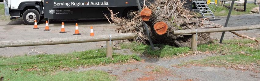
Airlie Beach Government Recovery Service Trailer ‐ 7 April 2017
Dr Yetta Gurtner and Dr Astrid Vachette
(Centre for Disaster Studies, James Cook University)
*Corresponding author: +61 747815617| yetta.gurtner@jcu.edu.au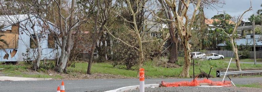
CONTENTS

BACKGROUND ‐ TROPICAL CYCLONE DEBBIE ............................................................................................. 3
   Wind damage .......................................................................................................................................... 3
   Storm surge............................................................................................................................................. 3
   Severe Weather/Flooding ....................................................................................................................... 3
SYNOPSIS OF BUREAU OF METEOROLOGY WATCH AND WARNINGS ........................................................ 5
WHITSUNDAY COAST COMMUNITY POST IMPACT ASSESSMENT – RAPID APPRAISAL.............................. 6
OBSERVED IMPACT/DAMAGE..................................................................................................................... 7
   Bowen ..................................................................................................................................................... 7
   Cannonvale and Airlie Beach .................................................................................................................. 9
   Shute Harbour....................................................................................................................................... 12
   Dingo Beach and Hideaway Bay ........................................................................................................... 12
   Proserpine ............................................................................................................................................. 12
COMMUNITY AWARENESS AND PREPAREDNESS PRE‐EVENT .................................................................. 16
   Risk and Hazard Awareness .................................................................................................................. 16
   Pre‐Event Preparedness ....................................................................................................................... 16
SHELTERING AND EVACUATION BEHAVIOUR ........................................................................................... 18
   Evacuation ............................................................................................................................................ 18
   Shelter in place ..................................................................................................................................... 19
INITIAL EVENT IMPACTS............................................................................................................................ 19
   Loss of power and communication ....................................................................................................... 19
   Food, water and supplies ...................................................................................................................... 21
   Wind and flood damage ....................................................................................................................... 21
RESPONSE AND EARLY COMMUNITY RECOVERY ..................................................................................... 22
   Community capacity and government support .................................................................................... 23
   Recovery hubs....................................................................................................................................... 24
   Transition to recovery........................................................................................................................... 25
KEY LESSONS AND RECOMMENDATIONS ................................................................................................. 27
CONCLUSION ............................................................................................................................................ 28
ACKNOWLEDGEMENTS ............................................................................................................................. 29
REFERENCES .............................................................................................................................................. 30
BACKGROUND ‐ TROPICAL CYCLONE DEBBIE

On Tuesday 21 March 2017, a well‐defined but weak area of low pressure developed over the
North Coral Sea (southeast of New Guinea). Over subsequent days, environmental and weather
conditions supported the intensification of a tropical low developing over the Coral Sea Islands.
On Saturday 25 March the Australian Bureau of Meteorology (BOM) classified the system as
Category 1 Tropical Cyclone Debbie.

As this cyclone tracked slowly west‐south‐west and south‐south‐west towards the North
Queensland coastline, it continued to intensify until Category 4 Severe Tropical Cyclone Debbie
finally made landfall near Airlie Beach around 11:50am on Tuesday 28 March, 2017 (refer to
Figure 1). It continued as a slow‐moving system generating wind gusts in excess of 160
kilometres per hour (kmph), heavy rainfall and large waves along the coast. Tracking further
inland over the townships of Proserpine and Collinsville, more than 24 hours later it was finally
downgraded to a Tropical Low where it continued to generate heavy rainfall in its pathway.

The primary hazard risks associated with Tropical Cyclone Debbie (TC Debbie) were the
destructive winds, storm surge and the significant rainfall with the potential to lead to localized
flooding.

Wind damage
As a Severe Category 4 Tropical Cyclone, Debbie was expected to generate wind speeds up to
158 – 198kmph with gusts to 226 – 280kmph (BOM 2017). Official measurements from BOM on
Hamilton Island recorded gusts of 263kmph. With a destructive core estimated to be
approximately 100km wide, the Whitsunday Islands were directly exposed to damaging winds
for many hours with the jetty at Daydream Island eventually washed away. As the cyclone
subsequently crossed the coastline, wind speeds varied in accordance with proximity to the
core, local geography and topography. The highest recorded gusts in Bowen were 148kmph
and 165kmph in Proserpine (Gourlay, Liddy, Spraggon, & Tilley 2017).

Storm surge
Given the slow and slightly erratic movement of the system as it approached the coast there
was significant uncertainty in predicting the exact time and location of landfall. With over 600km
of susceptible coastline (refer Figure 2), a crossing with high tide was anticipated to result in a
potential storm surge of between 2.5‐4m with damaging waves, strong currents and floods that
may swamp low lying areas. As a precaution, thousands of residents in exposed coastal “red
and orange zones” were asked to evacuate prior to the cyclone impact. With landfall eventually
occurring approximately two hours after the morning high tide, on a section of the coast
partially shadowed by the Whitsunday Islands, the observed storm surge impacts were limited.

Severe Weather/Flooding
TC Debbie was expected to bring torrential rainfall of between 400‐500mm to affected regions,
generating a significant risk of flash flooding and flooding in local catchments. As over 320mm
fell within 24 hours around Bowen and Proserpine, many homes and businesses were inundated
and local road networks were cut.
Tropical Cyclone Debbie: Community Post Impact Assessment – Rapid Appraisal
                                                                                                 3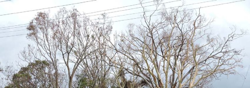
Figure 1. Bureau of Meteorology Tracking Map of Tropical Cyclone Debbie 29 March 2017

Figure 2. Bureau of Meteorology Satellite Image Tropical Cyclone Debbie 28 March 2017

Tropical Cyclone Debbie: Community Post Impact Assessment – Rapid Appraisal
                                                                                        4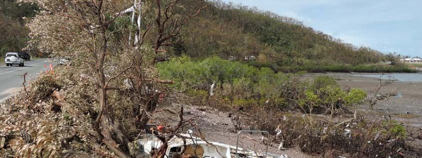
SYNOPSIS OF BUREAU OF METEOROLOGY WATCH AND WARNINGS

The first Tropical Cyclone Advice for TC Debbie was issued by BOM just after lunch on Friday 24
March, as a Coral Sea tropical low expected to develop and move towards the coast over the
weekend. Within 24 hours the system had developed into a Category 1 cyclone with all
indications that it would continue to intensify, and a “watch” notification was issued for
communities along the east coast of Queensland from Cape Tribulation south to St Lawrence. A
tropical cyclone “watch” is issued for coastal communities when the onset of gales is expected
within 48 hours, but not within 24 hours (BOM 2017).

Six hours later, (Saturday 25 March 4:54pm) the next advice issued an upgraded “warning”
notification for communities between Ayr and St Lawrence, with the watch zone between Cairns
and Ayr. A tropical cyclone warning is issued for coastal communities when the onset of gales
is expected within 24 hours, or are already occurring. On Sunday, communities in low lying
coastal areas (Red and Orange storm surge zones) from Rollingstone to Mackay where advised
to finalise cyclone preparations, pack evacuation kits, and evacuate due to storm surge risk.
Flights and ferries for the Whitsunday Islands were cancelled and evacuations shelters were
being prepared in “at risk” communities, to be open as needed.

As communities made final preparations, the tracking speed of TC Debbie slowed and it adopted
a west‐southwest track with Tropical Cyclone Advice 14 issued at 4:53pm Sunday 26 March,
extending the warning zone north, from Lucinda to St Lawrence. The associated watch zone was
between Innisfail to Lucinda, extending west past Charters Towers and Mt Coolon. By Monday
morning, TC Debbie had intensified to a large Category 4. The warning zone again expanded,
covering Cardwell to St Lawrence, forecast to make landfall between Cape Upstart and Cape
Hillsborough (north of Mackay) on Tuesday morning. Flights were cancelled at local airports
and schools throughout the region were closed. From 2pm on Monday weather updates were
issued hourly.

As TC Debbie continued to meander southwest to south‐southwest the warnings and forecast
tracking maps altered accordingly. Late Monday night the warning zone had been refined to
Lucinda to St Lawrence, and inland from these locations. With the cyclone forecast to make
landfall between Ayr and Cape Hillsborough (north of Mackay) on Tuesday morning ‐ potentially
coinciding with high tide ‐ 25,000 people from low lying regions from Mackay were ordered to
evacuate as a precaution. By Tuesday morning it was evident that the system had continued to
slow its tracking speed, with small temporary variations affecting landfall forecasts. The time
frame for the expected coastal crossing had also been delayed.

Tropical Cyclone Advice Number 43 issued at 11:58am Tuesday 28 March, indicated that the
system had begun to make landfall on the mainland between Bowen and Airlie Beach. It was
expected to continue to move gradually west‐southwest inland over the subsequent 12‐24
hours and weaken. With wind gusts up to 270kmph near the centre, residents in affected areas
were advised to remain indoors until emergency authorities advised it was safe to go outside or
return home. The official warning zone extended from Townsville to St Lawrence, including
Mackay, and the Whitsunday Islands, and inland to Charters Towers, Mount Coolon, Moranbah,
and Pentland. Passing over Proserpine several hours later as a Category 3 cyclone, TC Debbie
further weakened as it moved inland southwest of Collinsville around 10pm Tuesday night.
Almost five days after the first advice was issued by BOM, TC Debbie dissipated to a tropical low
on Wednesday 29 March, with significant torrential rain and flooding to follow.
Tropical Cyclone Debbie: Community Post Impact Assessment – Rapid Appraisal
                                                                                               5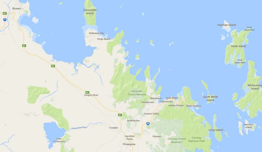
WHITSUNDAY COAST COMMUNITY POST IMPACT ASSESSMENT – RAPID APPRAISAL

Given the proximity of the impacted region, social researchers from the Centre for Disaster
Studies, James Cook University visited the communities of Bowen, Cannonvale, Airlie Beach and
Proserpine between 5‐8 April 2017 to undertake unstructured/informal and semi‐structured
interviews with residents, community support providers, and a number business operators in
order to gain preliminary insights into Tropical Cyclone Debbie impacts. Key themes addressed
were; hazard awareness and preparedness; sheltering and evacuation behaviour; and initial
recovery progress.

To minimise duress and any imposition on potential informants’ time, the majority of interviews
were conducted as people were waiting at established local Community Recovery Hubs (with
the permission from each recovery centre manager). In addition to numerous government
departments offering disaster relief and recovery assistance and advice, the variable range of
community support services available for residents at these “hubs” included, Lifeline
(counselling), Salvation Army, Red Cross, SES, insurance representatives/assessors, and
telephone companies offering mobile phone charge points and credit. Various agencies and
community organisations also provided simple respite items such as water, sausage sizzles, and
basic first aid and cleaning supplies.

During the rapid appraisal period researchers travelled over 900km from Townsville to Bowen,
Cannonvale, Airlie Beach, Shute Harbour, Dingo Beach and Proserpine (refer to Figure 3),
interviewing 19 community members, 4 business operators and 18 community support
personnel. An integral component of this community recovery assessment was also direct
observation of evident damage, impacts, and the extent of visible clean‐up/recovery achieved.

Figure 3. Location of impacted Whitsunday Coast communities visited (Google Maps)

Tropical Cyclone Debbie: Community Post Impact Assessment – Rapid Appraisal
                                                                                             6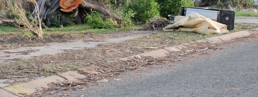
OBSERVED IMPACT/DAMAGE
Given that little more than a week had passed since the impact of TC Debbie, each of the
locations visited for this report continued to show clear evidence of damage and debris with
variable progress in both individual and community clean‐up. While the extent of visible
structural damage on buildings and dwellings was more obvious in the higher wind impact
regions of Proserpine and Shute Harbour, vegetation devastation was extensive throughout the
Whitsunday coastal region. Roads and electricity network infrastructure had also suffered
significant obstructions and damage, delaying many response and recovery initiatives.
Highway traffic during this period was predominantly military vehicles, trade and service utilities
and the police. Almost all of the local accommodation throughout the region was fully occupied
by response and recovery workers. Backpackers in self‐contained campervans were still
numerous, particularly around Airlie Beach. As the week progressed, more civilian/resident
vehicles were observed, especially around the local shopping centres and hardware districts. In
each region the extent of visible community activity and clean‐up progress mirrored the
availability of resources and services such as manual labour, electricity restoration, and debris
removal.
Bowen
In the coastal township of Bowen (population 10260, 2011 census ‐ ABS 2017) over 5500
residents were ordered to evacuate prior to the impact of TC Debbie. As the majority of
buildings were constructed prior to 1985 and the introduction of cyclone building standards,
there were significant concerns about direct exposure to destructive winds and the predicted
storm surge (Haynes 2017). While the wind speeds experienced were not as strong as in Airlie
Beach and Proserpine (on the southern edge of the cyclone) the torrential rain fall and severe
thunderstorm the following night caused the local Don River to break it banks, with resultant
localised flooding.
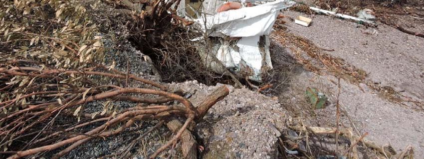
Physical damage observed in Bowen during the fieldwork period was predominantly vegetation,
with abundant denuded, fallen and uprooted trees, and as a result, large collections of
residential “green waste” amassed for kerbside collection (refer Figure 4). While there
appeared to be limited external, structural damage to dwellings, piles of discarded carpets and
other water‐damaged household items reflected considerable water intrusion. Numerous
fences, particularly those constructed from Colourbond panels and wooden palings had been
knocked over. Along the beachfront area there was abundant trees, palms and coconut debris
yet little indication of significant storm surge damage. Signage however, advised that town
storm water had brought sewage overflow out to the ocean (refer Figure 5).
With the restoration of power and household bins out for collection, essential services appeared
to have returned for most residents. Businesses and amenities were progressively resuming
operations. In addition to the numerous contractor vehicles and utilities on suburban streets
there was an obvious police presence both checking houses and talking to residents.
Tropical Cyclone Debbie: Community Post Impact Assessment – Rapid Appraisal
7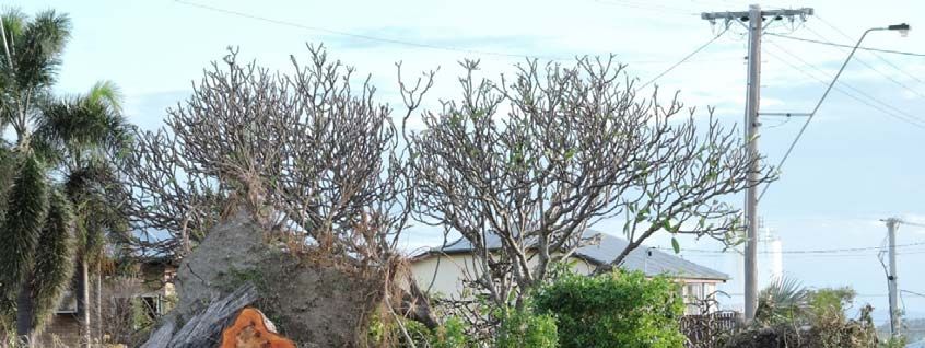
Figure 4. Uprooted trees, vegetation and water damaged household items on footpath in
Bowen

Figure 5. Sewage stormwater overflow into the ocean, Bowen

Tropical Cyclone Debbie: Community Post Impact Assessment – Rapid Appraisal
                                                                                        8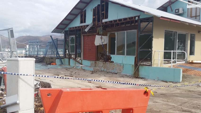
Cannonvale and Airlie Beach
The Cannonvale and Airlie Beach section of the Whitsundays coast (including Woodwark, Jubilee
Pocket and Flametree) is widely known for tourism. As the access point to the Whitsunday
Islands, and the internationally acclaimed White Haven Beach the majority of the estimated
7868 residents (2011 census ‐ ABS 2017) are employed in accommodation, food services and
tourism services. The building and construction, and the coal mining sector are also major
employers. In addition to the direct risk to life and property TC Debbie posed for the
Whitsunday Islands and this expanse of coastline, it also represented a major threat to the $2
million a day regional tourism industry (Craw 2017).

With the significant damage sustained to both dwellings and infrastructure on Hamilton,
Hayman and Daydream Island these prime tourist destinations were not open for public access
during the fieldwork period, although Hamilton began to advertise the availability of reduced
tourism services again on April 8, 2017. Repairs to boats, yachts and damaged infrastructure at
Abell Point Marina were similarly expedited to facilitate the resumption of cruise and transport
operations.

As this part of the tourism industry worked to restore both services and image, the environment
and stark hillslopes throughout the region clearly showed the degree of destructive winds
experienced. Trees were broken and battered with minimal remanent foliage, shed roofs and
roadside advertising signs were bent and had lost panelling, while powerlines dangled loose
beside fallen power poles. In the suburbs, the clean‐up process had clearly begun, however the
majority of visible activity appeared to be contractors lopping trees, clearing green waste in
public areas, and working to restore electricity networks. Unlike Bowen, there were few
apparent piles of residential debris kerbside, yet many yards still revealed fallen branches,
uprooted trees, and other vegetation damage.

The small coastal town of Cannonvale, directly west of Airlie Beach appeared to represent the
main commercial centre for the region’s residential community recovery efforts, providing
supplies and services via the Whitsundays Shopping Centre and Plaza, Bunnings, the temporary
green waste dump (refer to Figure 7) and the Community Recovery Hub. Reopened
supermarkets and businesses selling fresh produce (ie the butcher and bakery) were particularly
popular. Although a number of houses and strata title units demonstrated clear structural
damage related to roof battening or airborne debris (refer to figure 8) and several boats were
washed up along the shorefront, the overall level of structural damage observed around
Cannonvale was limited.

Airlie Beach located 3km away, clearly reflected a tourism oriented resort town assiduously
working to clean up and resume operational capacity, relying extensively on generators, manual
labour and staff activities (refer to Figure 8). Commercial rubbish skips were full of damp
discarded carpets; ceiling insulation and water‐damaged fittings, suggesting significant water
infiltration had occurred (refer Figure 9). Despite the concerted efforts of Energy Queensland
electrical power had not yet been restored to all premises with less than half open for business,
predominantly those offering food, beverages, travel services and souvenirs. Lacking electricity
or a back‐up generator many accommodation service providers were forced to remain closed,
as a reasonable number of more independent tourists stayed in self‐sufficient campervans in
the shorefront parking lots.

Tropical Cyclone Debbie: Community Post Impact Assessment – Rapid Appraisal
                                                                                               9
Figure 6. Temporary local green waste dump and mulching, Cannonvale
Figure 7. Structural damage and foliage loss, Cannonvale
Tropical Cyclone Debbie: Community Post Impact Assessment – Rapid Appraisal
10Figure 8. Generator power to assist clean up and resumption of business operations, Airlie
Beach
Figure 9. Business clean up post‐cyclone and flooding Airlie Beach
Tropical Cyclone Debbie: Community Post Impact Assessment – Rapid Appraisal
11Shute Harbour
Formerly the main departure point to the Whitsunday Islands and the Great Barrier Reef, Shute
Harbour including Mount Rooper and Shutehaven, supports a small population, recorded as 95
people in the 2011 census (ABS 2017). With a median monthly mortgage repayment of $6067
most of the houses in this area represent prestigious higher value luxury dwellings of newer
construction, predominantly used as holiday accommodation. The majority of dwellings are
located on the hillside overlooking the harbour and were not vulnerable to the storm surge
hazard associated with TC Debbie, however were directly exposed to the damaging winds. With
the extensive private and commercial boating within the harbour, a mandatory evacuation
order was communicated to anyone residing in and around the low‐lying areas – either on land
or on the ocean.
Despite evidence of initial clean up and salvage efforts, access to the Shute Harbour area
showed extensive damage sustained to physical infrastructure, vessels and vegetation.
Numerous boats and yachts were washed up, or destroyed, with debris strewn throughout the
mangroves and mudflats along the coastline leading to the harbour (refer Figure 10). In the
harbour itself, a further two vessels had clearly sunk. Having sustained extensive structural and
internal damage the visitor centre had been gutted of all fittings, and cordoned off from public
access (refer Figure 11). Jetty infrastructure, moorings and even the shore‐side cement
footpath had become considerably cracked and broken. Repair and restoration to operational
capacity is likely to be significant. Around the Shutehaven community, a number of garage
doors appeared to have blown in, with a small quantity of discarded carpets and household
furniture evident, however the majority of visible damage was limited to surrounding trees and
bushes.
Dingo Beach and Hideaway Bay
Dingo Beach and Hideaway Bay are part of a small remote coastal beach settlement located
50km north of Airlie. In the 2011 census (ABS 2017) the population was recorded at 420,
predominantly older residents (median age of 56) with no dependent children. The community
of Dingo Beach was ordered to evacuate due to storm surge risk on Sunday 26 March. Although
the structural damage and the storm surge experienced in this region was not as significant as
feared, debris and flooding from TC Debbie prevented access to the community for several days
after the event (the road reopened Friday 31 March). During this time, residents that opted to
shelter in place were left isolated with no power and no additional food or fuel supplies once
the only local store had diminished available stock. Despite popular perception that the entire
community had been completely neglected in any response and recovery efforts, a site visit
showed that the clean‐up process on the foreshore was well underway (and near completion),
the local store had both food and drink stock (but no fuel in the bowsers) and a recovery based
NGO had established a formal presence.
Proserpine
Having recorded gusts up to 165kmph the small inland rural town of Proserpine (population
3,390, 2011 census – ABS 2017) experienced substantial wind damage to both the natural
environment and older housing stock during TC Debbie (refer Figure 12 and 13). Torrential
rainfall and the severe storm the following night also caused the Proserpine River to flood,
cutting off roads and exacerbating adverse conditions for residents. As one of the worst
affected mainland communities, Proserpine became the central focus of extensive military
support and recovery efforts.
Tropical Cyclone Debbie: Community Post Impact Assessment – Rapid Appraisal
12Figure 10. Smashed boat and debris in mangroves, Shute Harbour
Figure 11. Extensive cyclone damage evident at Shute Harbour terminal
Tropical Cyclone Debbie: Community Post Impact Assessment – Rapid Appraisal
13Figure 12. Extensive business premises damage, Proserpine
Figure 13. Asbestos identified as a further hazard in damaged housing, Proserpine
Tropical Cyclone Debbie: Community Post Impact Assessment – Rapid Appraisal
14While significant damage to buildings and dwellings was still apparent on April 7, the majority
of yards and streetscapes around the community of Proserpine had already been cleared of
debris. Consistently, the military personnel were progressively withdrawing from the town.
Both power and structural integrity appeared critical determinants in the restoration of
community based businesses and services, with many still not operational. SES crews, trade
vehicles, contractors and assessors remained abundant, working with individuals and
community to return a degree of normalcy.
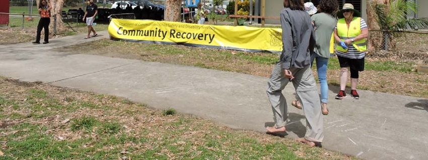
As each affected community continued with the clean‐up and recovery efforts, any person
directly impacted by TC Debbie was recommended to visit the official Community Disaster
Recovery Hub set up in their locality to receive support, advice and financial assistance (where
eligible). The three primary Recovery Hubs in the Whitsunday coastal region were established
at the Bowen TAFE campus, Cannonvale State School and Proserpine State High School. The
majority of informants for this research were accessed in these locations.
Figure 14. Cannonvale Community Recovery Hub
Tropical Cyclone Debbie: Community Post Impact Assessment – Rapid Appraisal
15COMMUNITY AWARENESS AND PREPAREDNESS PRE‐EVENT
Risk and Hazard Awareness
Although informants for this rapid community assessment were asked to retrospectively
comment on their preparation before TC Debbie, each person interviewed indicated that they
were well aware of potential cyclone hazards prior to the event, having received information
and advice from a variety of sources including local council, television, radio, print and social
media, friends, and family. As most also had previous cyclone experience they knew that
residents in the forecast impact zone should; tidy up loose items in yards and gardens; tie down
sheds, boats and trampolines; secure windows, doors and external fittings; sandbag buildings
prone to flooding; and, organise sufficient food, water and relevant supplies.
While familiar with the risks of wind damage and storm surge exposure for any resident living
along the foreshore, there was less clarity regarding the demarcation of storm surge and flood
zones in relation to the position of personal dwellings. A number of informants indicated that
they knew they were in the “Red Zone” for storm surge inundation, as they lived in low lying
areas close to the coast, however were not able to clearly identify risk exposure to riverine
and/or flash flooding. Other residents were unsure of their susceptibility to any type of water
inundation threat. Consistent with this degree of uncertainty, none of the informants advised
that they had an established, written disaster plan for their household prior to the event.
Demographic characteristics, household composition, dwelling type, home ownership, rental
occupancy, and insurance coverage was highly variable between individuals, and had limited
apparent influence on early planning or preparation activities.
Pre‐Event Preparedness (community response to cyclone watch/warnings)
As TC Debbie was a large, relatively slow moving system that altered track a number of times
prior to making landfall, informants reported being initially complacent about their preparation
activities. Given the extensive cyclone “watch” and “warning” zones initially identified by BOM,
many chose not to undertake recommended actions until it was evident that the winds were
starting to pick up in their region. Such activities included cleaning yards, moving household
items that would be subject to flooding, securing property, and organising disaster kits. Friends,
family and social networks were apparent in this preparation process; however, a number of
informants also indicated that they were socially isolated and had to manage alone.
It was a slow system; everyone kept saying it was going to hit Townsville. So Townsville got
ready. For days it was Townsville, Townsville, Townsville – then it was all about Ayr…It wasn’t
until the day before when the winds started to pick up that we knew it was coming our way.
We were prepared even if it was last minute, but no one expected a bloody Cat 4 to come!
Resident – Jubilee Pocket
My husband works for the Department of Agriculture and that is how I found out that a
cyclone was coming. After that I sought information on the BOM website. We started to cut
trees, especially palm trees, to minimise the risks. We knew what to do from previous
experience, I knew what to do. The BOM website did not teach me anything new except for the
change of track. Resident – Bowen
Tropical Cyclone Debbie: Community Post Impact Assessment – Rapid Appraisal
16We knew how to prepare for the cyclone, we had a cyclone kit and we trimmed trees, but there
is only so much you can do alone. No one came to help us. My daughter and son‐in‐law took
charge of me… Resident – Airlie Beach
While BOM proved to be the primary source of warning and threat information for TC Debbie,
there was significant variability in how the information provided was perceived and understood.
There was also a substantial degree of uncertainty about how the warning/potential impact
messages translated at the localised level.
We used television and radio, we found out about the cyclone through the news, and listened
to reports from BOM, but this was not very informative, or we missed the key information. The
website of BOM was too complicated for us…We don’t have Facebook but our son from
Townsville was texting and calling to give us information he got from Facebook. We got a lot
out of that. ...The cyclone caught us off guard, as we did not think it was going to hit us based
on the maps. We received very last minute warnings only. Resident – Bowen
BOM got it all wrong…There was so much conflicting information that only focused on the big
towns, and this information was inadequate for understanding what it meant for our area.
This region has very different geography, different areas and suburbs ‐ there is Cannonvale,
Airlie, Jubilee Pocket, Shute Harbour – we all have different risks and needs but the focus was
always on the big towns so we didn’t know what it meant for us… Resident – Jubilee Pocket
Several informants mentioned that rather than just providing valuable information, some
commercial and social media networks heightened emotions such as stress and apprehension
in the lead up to TC Debbie. They referred to the sensationalism evidenced in extensive images
of previous cyclone damage and destruction, direct comparisons with large scale, severe
tropical cyclone events such as Yasi and Larry, labels such as “monster cyclone” and “a one in
100‐year event”, and excessive commentary on potential adverse social, environmental and
economic impacts. It was difficult for residents to identify clear, direct and meaningful
information.
Consistently, there was a lot of media attention given to the preparation and purchasing
behaviour of residents in the predicted impact zones – particularly notions of “panic buying” or
excessive, unnecessary, stockpiling resulting in empty shelves in local supermarket and
hardware stores. Although many retailers have developed restock contingency plans for such
last minute or “just in time” purchasing, an instinctive behavioural response to feel prepared
combined with supposed shortages created further community anxiety. Informants indicated
they also ensured they had sufficient food, water and supplies during this period.
I felt well prepared. I went to the supermarket the day before to buy some last‐minute
supplies, just some bread and a couple packets of chips. The shelves were almost empty ‐
people were “panic buying”. The community was highly stressed, everyone was tense. A lady
at the checkout in front of me was trying to buy 3 slabs of water bottles. She was advised by
the checkout operator that due to low stocks customers were limited to one slab each. She
proceeded to pick up the extra 2 slabs and threw them to the ground where they smashed,
proclaiming, “Well if I can’t have them no one else will either” Resident ‐ Bowen
Tropical Cyclone Debbie: Community Post Impact Assessment – Rapid Appraisal
17As TC Debbie strengthened towards a Category 4 cyclone on Sunday 26 March, residents were
advised to finalise their preparations. With regional commercial flights cancelled and all schools
officially closed, several local shops and business also opted not to open on the day prior to the
cyclone making landfall.
SHELTERING AND EVACUATION BEHAVIOUR
Both directed (mandatory) and voluntary evacuation orders were communicated in the days
prior to TC Debbie, targeting residents in low lying areas consistent with established storm surge
and flood zones. These evacuation messages were delivered via the radio, television, print and
social media, text message, and/or in person by police and emergency service personnel.
Individual responses to this evacuation advice appears to have reflected personal circumstances
and risk perceptions more than official warnings, zones or exposure. The role of clear targeted
information, social networks (friends and family), transportation, pets, and perceptions of
evacuation shelters were prominent in many of the narratives.
Evacuation
Reflecting a high degree of uncertainty and hesitancy, only a small number of informants
claimed to have evacuated their dwellings prior to TC Debbie. This included voluntary and
mandated evacuations to friends and family and official guidance to seek refuge within
established evacuation shelters if no other option was available. A reported 200 backpackers
and tourists from the Airlie region were bused to Rockhampton on Monday 27 March (Lyons
2017).
We decided to evacuate voluntarily as we were not sure about our house, even if it is not very
old. We have a 10‐month‐old baby so it changes your perspective, we might even have stayed
if it was just my husband and me. Instead we went to our friend’s place which we knew was
safer, in a higher area. Since the cyclone however, my baby is much clingier and more
demanding. Resident – Airlie Beach
The police came around to my place and told me that I had to evacuate as I was in the “red
zone” for storm surge. As I only have a bicycle they offered me a lift…but a friend came on
Monday before noon and drove me to their place where I stayed safely overnight. Resident –
Bowen
I was told by the police to get out of my hut, but I was misdirected and I went south towards
Bowen. When I arrived in front of the supermarket I realised that it was the wrong place to
evacuate as the threat was moving south, so I decided to go back to my hut. After that I did not
know where to go, so I decided to just stay there for the cyclone. Resident – north of Bowen
I was living on my boat in Shute Harbour with my two cats when the police issued a mandatory
evacuation order on Sunday – they said there was an imminent threat to life and property. As
the winds and rains had already started to pick up I had limited time to grab any personal
possessions. I didn’t have any cages or anywhere to take the cats so I was forced to leave them
behind on the boat… I don’t really know anyone here and don’t have a car or anything so the
police drove me to the Airlie PCYC evacuation shelter. Resident – Shute Harbour (boat)
Tropical Cyclone Debbie: Community Post Impact Assessment – Rapid Appraisal
18Shelter in place
The reasons given by residents for not evacuating or opting to shelter in place were numerous.
Several people said that they had not been advised to evacuate, or did not understand the
warning messages, so simply decided to stay. Others felt that they would be safer and more
comfortable in their own homes during the cyclone event. Commitment to personal pets and
poor perceptions of evacuation centres were the most frequent explanations provided.
There was an evacuation order for my street the day before Debbie but I don’t trust the police
so I didn’t open the door to receive the message. I chose to stay – I reckon about 70% of my
neighbours also stayed. I taped my windows and “bunkered down” ‐ I wasn’t worried about
looting or anything. … I have no friends or family, I am a loner and prefer my own company – I
had no interest in going to an evacuation centre. I wouldn’t be able to cope with my anxiety
and dislike of crowds or large amounts of people. I have heard they are crowded, confined and
uncomfortable. Resident ‐ Bowen
The police ordered an evacuation but I did not leave because I have a 10‐month‐old pup and a
cat – also I don’t like being around a lot of people so I really didn’t want to go to a cramped
evacuation centre, it was not “appealing”. I would rather take the risk and be comfortable,
my house is solid and raised 7ft. Resident ‐ Bowen
I wouldn’t have left anyway – evacuation centres don’t take dogs and I wasn’t leaving my dogs
behind – lots of people didn’t leave because of their dogs Resident – Airlie Beach
In discussing evacuation behaviour one informant relayed their concern regarding an elderly
neighbour with limited mobility and a reliance on medical support that did not appear to receive
any medical assistance to relocate to the local hospital prior to TC Debbie, effectively left to
shelter in place with his wife. There were also many reports about tourists and residents unable
to evacuate in time and subsequently left “stranded” on Whitsunday Islands. The Australian
newspaper (2017) reported that on the night of 28 March, 283 Bowen residents sought refuge
at Bowen State High School, 26 were at the Bowen Courthouse with 53 in evacuation shelters
in Proserpine.
INITIAL EVENT IMPACTS
Loss of power and communication
As TC Debbie approached landfall and progressively increased intensity, most residents kept up‐
to‐date with the weather and local conditions through conventional means such television,
radio, the internet and phone. A large number of informants admitted that they also relied
considerably on their mobile phones to access further information and maintain personal
communication with friends and family. With the inevitable loss of power from the damaging
winds, television, fixed broadband/NBN and digital/VOIP phone services were no longer viable
forms of information or communication for impacted residents. Where available, informants
were left to rely on mobile phones and/or radios for continued information about the event,
yet these options had evident limitations.
Tropical Cyclone Debbie: Community Post Impact Assessment – Rapid Appraisal
19I mainly got my information from the Internet until it went down. I only checked the BOM
website. The information from BOM was really good, but that is only a source of information
while the power is on, once it is down, we don’t have any other source of information. … We
only had a small AM radio as TC Debbie destroyed the big FM radio. There was absolutely NO
useful information on the radio. I don’t understand why the local radio was not more
informative. Resident ‐ Bowen
I mainly used the radio on my phone for information and warnings as I did not have a
transistor radio. As the event got closer the coverage/reception cut out and then my battery
died. I have a radio in my old car, it doesn’t have AC, but I didn’t think about it until days later
– I could have used my car radio to hear what was going on, the whole world could have been
destroyed by Cyclone Debbie for all I knew. Resident – Bowen
I listened to the local ABC radio which provided adequate warning information initially,
however I lost reception in the event and was unable to receive any signal since the hills
interfere with transmission on the transistor radio… I have no phone or internet… They need to
SIMPLIFY the communication and messaging, Radio National changed its focus to Airlie,
Proserpine and Mackay with no local information on Bowen – Bowen was ignored as if “they
will be fine” Resident ‐ Bowen
Used for a variety of purposes such as maintaining direct contact with friends, neighbours
and/or relatives; accessing information on the internet and social media; entertainment; and
even as a torch; the obvious constraint with mobile phones in this context was the limited
battery life and need to recharge. While there are power saving settings, power banks, or even
the capacity to recharge via the car, these options are only viable for a short period. Residents
on pre‐paid mobile plans with call, text and/or data caps had further restrictions. When trying
to access information wirelessly on mobile phones informants indicated that they found the
majority of official websites poorly suited to this type of use; with excessive data consumption,
slow content downloads, and difficulties in locating or navigating to relevant information.
Despite issues regarding the accuracy of information and advice available, Facebook and social
networks became key resources.
Reflecting the increasing popularity and reliance on developing technology, very few informants
owned a battery operated radio as an emergency back‐up option. For those that did manage
to access radio communications there were a number of reported issues including the loss of
local reception, poor transmission quality, and a perceived lack of local content, knowledge and
timely information. Without functional mobile phones or radios many individuals and
households felt isolated for days after the event, reliant on direct contact with social networks
to keep them appraised of local recovery advice and initiatives. Consistently residents that were
more solitary or marginalised did not have access to relevant information about water
sanitation, food provision or available support services. Given the scale of the event, response
agencies had limited resources, personnel and capacity to provide direct outreach.
The Police came to check on me twice – the first time was 2am the night of the storm (the
night following Debbie) as apparently a family member expressed concern and wanted to
know that I was ok. The following night my house was spotlighted by an official
vehicle…Communication was really poor ‐ no one knew what was going on, no one was telling
anyone anything – I felt really “isolated” from the world Resident – Bowen
Tropical Cyclone Debbie: Community Post Impact Assessment – Rapid Appraisal
20Post event there was a COMPLETE lack of information. I did not know what to avoid and I
drank the water ‐ it tasted off Resident ‐ Bowen
Food, water and supplies
With the power loss extending beyond five days for most informants, access to fresh food and
clean drinking water had become an apparent issue. Although everyone claimed to have
prepared adequate supplies for the recommended 72 hour self‐sufficiency period, many
admitted to an overreliance on perishables which required refrigeration. Shortages were
exacerbated by the slow onset and extended duration of the event. The official warning period
for the region had commenced on Sunday, with many shops closed on Monday following advice
to keep all roads clear for emergency service personnel. The cyclone did not make landfall until
close to noon on Tuesday – however people had already started to consume their emergency
provisions. While extensive damage and clean‐up prevented most residents from leaving their
premises on the day following TC Debbie, torrential rainfall and localised flooding from the
severe storm on Wednesday night created further destruction and delays.
As I live alone I had a small fridge with enough food and water for 3 days. Most of my food
was perishable and started to go off after 3 days with no power. I still have no power. I don’t
know what to do about my medication – it is supposed to be refrigerated. Resident ‐ Bowen
I couldn’t get out to access the recovery centre or food due to damage and trees down, and the
flooding from the storm. Resident – Bowen
As local water processing had been compromised during the event, residents were also advised
to sterilise all tap water or rely strictly on bottled water until the issue had been resolved. A
number of informants indicated they had run out of bottled water in the first few days and did
not have adequate facilities to boil water without electricity. People similarly admitted that
their personal cyclone planning did not include items such as fuel, cash, cleaning supplies and
medication.
We were safe during the cyclone now the issue is that our car is blocked by trees so we can’t do
anything, I cannot go to work, I cannot get food, water or equipment to clean. My friend had to
pick me up today just so I could come to the recovery centre Resident – Airlie Beach
If I could do anything different or make recommendations it would be to put petrol in car and
to have cash ‐ we were stuck in the house for days but once it is over you want to be mobile
and be able to buy stuff Resident ‐ Bowen
Wind and flood damage
With the exception of the evacuated informant from Shute Harbour who lost her boat, all of her
possessions, and one of her cats, during TC Debbie, most informants only reported limited
structural damage to their property. This included varying extents of vegetation loss, shed and
fence damage, and water ingress through broken or poorly sealed windows, doors and roofs.
My house is ok but all the fences came down, lots of trees and bushes, some damaged tiles and
water inside the house… It’s not too bad but I don’t have contents insurance – just home
insurance so nothing inside is going to be covered Resident – Airlie Beach
Tropical Cyclone Debbie: Community Post Impact Assessment – Rapid Appraisal
21I have a wide experience of disasters, I have been living in the area for 20 years, but Debbie
was a real monster, it was very slow and just got bigger and bigger. Because it was so slow and
information kept changing it was so stressful. I found that it was one of the most frightening
disasters. I lost power, I lost internet and there was lots of water infiltration, but that was not
really scary as it is not a safety issue. What was scary was the roof of the shed that flew away.
Seeing that metallic sheet flying was very frightening Resident – Bowen
While people expected significant wind gusts and impacts associated with TC Debbie there
appeared to be less awareness and preparation for the severe storm and rainfall that affected
the community the following night. Most informants had not anticipated flooding after the
cyclone had made landfall, and in many cases existing damage was compounded.
Everyone knew the cyclone was coming, there was plenty of warning and plenty of
information, most of us have prepared before. There was no excuse for not being ready it was
so slow in developing… What we weren’t prepared for was how much rain came from the
storm the next night that’s where we suffered the most damage. Business operator ‐ Bowen
The house I live in is about 40 years old – there was extensive water intrusion through the ridge
caps and window seals, and the door blew in. I spent 16 hours the night of the cyclone
mopping up and 14 hours the night of the storm, I am still exhausted. Neither the real estate,
nor owner, have bothered to contact me or check. There is wet carpet, walls and fittings – I am
trying to dry it all out yet there are obvious issues of damage and I am worried about health
and sanitation issues including mould. I am pretty self‐reliant though, I will continue to clean it
up by myself. Resident ‐ Bowen
It was a 30 – 40 hour event. The wind kept howling ‐ it came from one way for 4‐5 hours, the
eye was 2‐3 hours big, and then we were hammered the other way. I have experienced nothing
like it… With the winds before and then the severe storm the next night – everything got
flooded, the ground was saturated and we lost even more trees Resident – Airlie Beach
In addition to the observed impacts on homes, businesses, and the natural environment,
preliminary wind and flood damage from TC Debbie included significant agricultural loss to
horticulture crops, sugar cane fields, irrigation equipment and cane train infrastructure.
Transport, water sanitation, and electricity network recovery was delayed by the extent of rain
and debris generated by the event. For Airlie Beach and the Whitsunday Islands the tourism
sector was faced with extensive damage to accommodation, hospitability services and cruising
infrastructure, with images and perceptions of complete destruction expected to result in
further widespread booking cancellations across the region. As contractors and emergency
service personnel worked on aspects of physical recovery, communities began to tackle social
recovery.
RESPONSE AND EARLY COMMUNITY RECOVERY
While the Australian Army proactively mobilised up to 1000 personnel, to clean up the roads
and debris, and/or provide engineering, humanitarian and emergency assistance (as soon as it
was considered safe after the event) communities had already commenced their own personal
damage assessment and clean‐up process.
Tropical Cyclone Debbie: Community Post Impact Assessment – Rapid Appraisal
22Community capacity and government support
In reviewing the first few days following TC Debbie, informants described varied response
behaviours. The majority of people indicated that friends, families, neighbours and/or other
spontaneous volunteers worked together to help clear roads, fix fences, remove yard debris and
damage, and share available resources. In some cases such altruism extended to the offer of
customised support and accommodation.
I cannot commend the community spirit and support enough ‐ everyone stepped up to help
each other. There was free food and water, and cook ups. “Whitsundays food service”
provided everyone from Jubilee Pocket free food at their own expense. … The tourists haven’t
stopped whinging it’s all they do, but some of them are good – there were a whole heap of
backpackers that were getting in and working and helping clean stuff off the roads ‐ was good
to see them helping in Airlie Resident – Jubilee Pocket
There has been incredible community support. There are 2 girls that are offering help to older
people, they are in the local pub and anyone can come and ask them to register them online
for recovery assistance. Community support officer ‐ Bowen
I am currently hosting 2 people who were previously strangers that I met at the PCYC
evacuation centre. The community was asking for help and I had the room. It’s what you do,
you help out. Some of these people had lost everything it was the least I can do, but, you
know, it cost money to feed and look after them and drive them around. I don’t want money or
anyone to think I am a hero or anything, it’s what anyone would do, but it’s hard Resident –
Airlie Beach
There was also a large number of emergent individuals and groups from other towns, and across
the impacted region, that self‐organised and mobilised donations of food, water, clothing, and
other relevant supplies to address an expected community need (refer Figure 15). Established
charity organisations such as the Salvation Army, Red Cross and Lifeline maintained an active
presence and role at the recovery hubs.
In the absence of mains electricity, businesses with access to generator power reopened as soon
as feasible to provide residents and emergency support personnel with meals, accommodation
and fresh supplies. Short term initiatives at some locations included free parking, free mobile
phone charging, free Wi‐Fi access and the option to withdraw cash through the provision of a
portable self‐powered ATMs.
In direct contrast to the prevailing community spirit of generosity and support, there were also
many rumours and unsubstantiated stories of looting, opportunism, price gouging and
profiteering in the days after the disaster. The police were quick to investigate any formal
complaints of illegal activity, and fortunately such cases appeared to be the exception rather
than the norm.
There was a woman on Facebook who was collecting donations and asking for money to
purchase extra supplies and transport them to the stricken areas – but she wasn’t part of any
recognised group or organisation – I don’t know if she actually delivered anything to anyone
Community support provider ‐ Cannonvale
Tropical Cyclone Debbie: Community Post Impact Assessment – Rapid Appraisal
23I heard that a guy went into Bunnings just before the cyclone and bought all of the generators
they had in stock, and then sold them for a huge profit to community the day after…
Community support provider ‐ Cannonvale
Although it was evident that people were working collectively towards community recovery,
some informants revealed limited initiative, with an underlying expectation that the
government should be doing more. In the aftermath of the event, informants reported waiting
in situ for authorities and outreach services to come directly to them to offer information,
support and/or assistance.
No one came to help, not the police, not the army, not the neighbours. I don’t even know how
my neighbours are doing. Everyone is working for themselves Resident ‐ Bowen
I have not spoken to my neighbours and no one has come to check on me to advise what is
going on. For two to three days there was no help, no advice and no updates. I had absolutely
no communication about any events or activities. I haven’t seen any emergency services, police
or even volunteers Resident ‐ Bowen
While operating primarily to support genuine community need post disaster, this culture of
dependency and entitlement was also recognised at the community recovery hubs.
People expect way too much from government support, they should do more on their own and
not wait for aid Community support provider ‐ Cannonvale
Recovery hubs
Managed by the Queensland Department of Communities, Child Safety and Disability Services
and staffed by a variety of government personnel and agencies; community organisations;
NGOs; volunteers; and; disaster recovery affiliated businesses, “recovery hubs” were
established in the major community centres from March 31 to provide face‐to‐face access to
financial assistance and support services for individuals and businesses directly affected by TC
Debbie. Described as chaotic in the initial days of operation, staff at each hub were assessing
more than 450 claimants each day with waiting periods in excess of 4 hours long (up to 7 hours
in Proserpine). In the absence of electricity or generator power most of the early information
collected was paper based, needing to be manually entered onto official systems (at an external
location) for further processing. Police and security personnel were initially present at the hubs
to diffuse any potential frustration or stress induced conflict.
Through experience, necessity, and increasing familiarity with operational requirements,
recovery hub support staff progressively introduced a more effective system of management to
triage individuals’ needs and processing requirements. While maintaining the set objective of
community recovery support, the management approach and atmosphere at each recovery hub
was discernibly different. This varied from a relatively relaxed, engaged yet casually efficient
environment to a much more strategic “command and control” authority structure and
presence, affecting community behaviour and attitudes accordingly. Given the expanding scale
of post TC Debbie impacts in other regions, sourcing of experienced, trained staff and fatigue
management became additional issues.
Tropical Cyclone Debbie: Community Post Impact Assessment – Rapid Appraisal
24You can also read