CONNECTING CORRIDORS TERAI ARC LANDSCAPE - NEPAL - WWF
←
→
Page content transcription
If your browser does not render page correctly, please read the page content below
NEPAL

        CONNECTING
         CORRIDORS
           TERAI ARC LANDSCAPE
CONTENTS
                                                                                                                                    MESSAGE                    1
                                                                                                                                    TESTIMONIALS               2
                                                                                                                                    NEPAL'S CORRIDOR HISTORY   4

                                                                                                                                    SHIKARIBAS                  8
                                                                                                                                    BARANDABHAR                18
                                                                                                                                    LAMAHI                     28
                                                                                                                                    KAMDI                      36
                                                                                                                                    KHATA                      46
                                                                                                                                    KARNALI                    58
© WWF 2021
All rights reserved.                                                                                                                BASANTA                    66
Any reproduction of this publication in full or in part must mention the title and credit WWF Nepal.
                                                                                                                                    LALJHADI-MOHANA            74
Citation:
Thapa, K., Tuladhar, S. (Eds.) 2021. Connecting Corridors. WWF Nepal, Kathmandu, Nepal.                                             BRAHMADEV                  84
Cover Image:
© Audra Melton / The Coca-Cola Company / WWF
Designed by:                                                                                                                        ACKNOWLEDGEMENTS           94
Kazi Studios
                                                                                                                                    CONTRIBUTORS               96
Published by:
WWF Nepal
PO Box: 7660
Baluwatar, Kathmandu, Nepal
T: +977 14434820, F: +977 1 4438458
info@wwfnepal.org, www.wwfnepal.org                                                                    © Ghana S Gurung/WWF Nepal

2
MESSAGE

                                                            WWF Nepal first embarked on its journey of conservation in the Terai       of multiple stakeholders, primarily local communities working
                                                            Arc Landscape in early 2001, when the landscapes in Nepal and India        tirelessly in diverse roles such as citizen scientists, community based
                                                            were home to an estimated 3,765 tigers; the highest number of tigers       anti-poaching units, forest guards and social mobilizers.
                                                            in the world. The Terai Arc Landscape was consequently accorded
                                                            the status of being one of the most critical tiger landscapes among        The two-decade long partnership with the government has yielded
                                                            13 tiger range countries. Unfortunately, these numbers saw a sharp         remarkable results with most of the corridors now fully functional.
                                                            decline in ensuing years, as poaching, habitat loss, degradation, and      WWF Nepal remains committed in supporting the Government of
                                                            human tiger conflict increased.                                            Nepal and its communities in corridor restoration efforts and also
                                                                                                                                       reaffirms its commitment to international initiatives such as the UN
                                                            The Terai Arc Landscape was conceptualised primarily based on the          Decade of Ecosystem Restoration (2021-2030) to ensure healthy
                                                            tiger dispersal model, which aimed to increase the persistence of tigers   ecosystems for the benefit of people and nature.
                                                            over a larger landscape, beyond initial source populations within
                                                            protected areas. This laid the foundations for conservation efforts in     This publication foregrounds the many interventions, achievements,
                                                            Nepal’s corridors, ranging from forest restoration, reducing threats       challenges, and setbacks faced while restoring the critical corridors of
                                                            to species, safeguarding livelihoods, to effective transboundary           the Terai Arc Landscape, accentuating the critical relationship with
                                                            cooperation between Nepal and India. Corridor functionality as             local communities, and conservation partners at the park, state, and
                                                            measured by tiger dispersal is evident in many corridors in the            government levels. I extend my sincere gratitude to the Government
                                                            landscape today. This functionality has triggered the importance of        of Nepal, our donors, the WWF Network, and our partners for joining
                                                            corridor connectivity, contributing towards the persistence of tigers in   forces in realizing our conservation goals in the Terai Arc Landscape.
                                                            the landscape. Today, the transboundary Terai Arc Landscape boasts
                                                            over 880 tigers; with both Nepal and India having close to doubled
                                                            their tiger numbers, a testament to the unwavering resolve and belief
                                                            in the landscape approach of conservation partners, positioning
                                                            Nepal as a leader in tiger conservation.

                                                            Since its first program was implemented in the Khata Corridor,
                                                            WWF Nepal has continued to galvanize its efforts towards improving         Ghana S Gurung, PhD
                                                            ecological connectivity between protected areas and enhancing
                                                            benefits to communities living alongside the corridors of Nepal.           Country Representative
                                                            This would not have been possible without the sustained efforts            WWF Nepal

    © Gary Van Wyk / The Ginkgo Agency / Whiskas / WWF-UK

4                                                                                                                                                                                                             1
TESTIMONIALS
               Terai Arc, Nepal is a priority landscape identified by the Government of                 Securing ecological connectivity and human wellbeing in the complex
               Nepal. Over the last twenty years the government has prioritized forest                  and ever more crowded landscapes of our planet is the conservation
               restoration initiatives and facilitated ecological connectivity along                    challenge of our time. This report showcases brilliantly how local
               these critical corridors identified in the Terai Arc Landscape. Nepal’s                  communities in Nepal have tackled this challenge head on, with
               work in ecological corridor connectivity is a tried and tested model,                    enormous success. Their leadership in restoring and managing
               replicable globally. This publication demonstrates the collaborative                     their forests in ways that strengthen their development as well as
               and cohesive efforts of the government—national, provincial                              providing permeability for wildlife is inspirational and gives us all
               and local—communities, conservation partners and                                         a fantastic base of lessons to scale up throughout Asia and beyond.
               other stakeholders.                                                                      The future still holds many challenges, and much support will be
                                                                                                        needed to holistically address these challenges to ensure a long-term

               KRISHNA PRASAD ACHARYA, PhD                                                              resilient future for people and wildlife in the Terai.

               SECRETARY, MINISTRY OF AGRICULTURE AND LIVESTOCK DEVELOPMENT                             WENDY ELLIOTT
               GOVERNMENT OF NEPAL
                                                                                                        DEPUTY LEADER, WILDLIFE PRACTICE
                                                                                                        WWF INTERNATIONAL

                                                                                          © WWF Nepal

               Guided by the Terai Arc Landscape Strategy and Action Plan, the                          In Nepal’s context, connectivity is key to the doubling of tigers in
               project is the longest running program by the Government of Nepal.                       the wild - which Nepal is on course to do. During the last 20 years,
               The Department of Forest and Soil Conservation in partnership                            interventions have been tried, tested and proven. The results speak
               with WWF Nepal continues to support on the ground forest                                 for themselves. From the siting of corridors and habitat restoration
               restoration initiatives, community stewardship programs, and                             to building community ownership and trust, these techniques have
               wildlife management in protected areas and corridors across the                          all contributed to the extraordinary success that is the Terai Arc
               landscape. The results over the last 20 years have been tremendous                       Landscape.
               with improved forest cover, wildlife dispersal and community
               stewardship. This publication not only documents the history of
               conservation in these corridors, but also outlines the emerging
               challenges and opportunities that lay ahead.                                             STUART CHAPMAN
                                                                                                        LEAD, TIGERS ALIVE INITIATIVE
               MAN BAHADUR KHADKA
               DIRECTOR GENERAL, DEPARTMENT OF FORESTS AND SOIL CONSERVATION
               MINISTRY OF FORESTS AND ENVIRONMENT

                                                                                          © WWF Nepal

2                                                                                                                                                                          3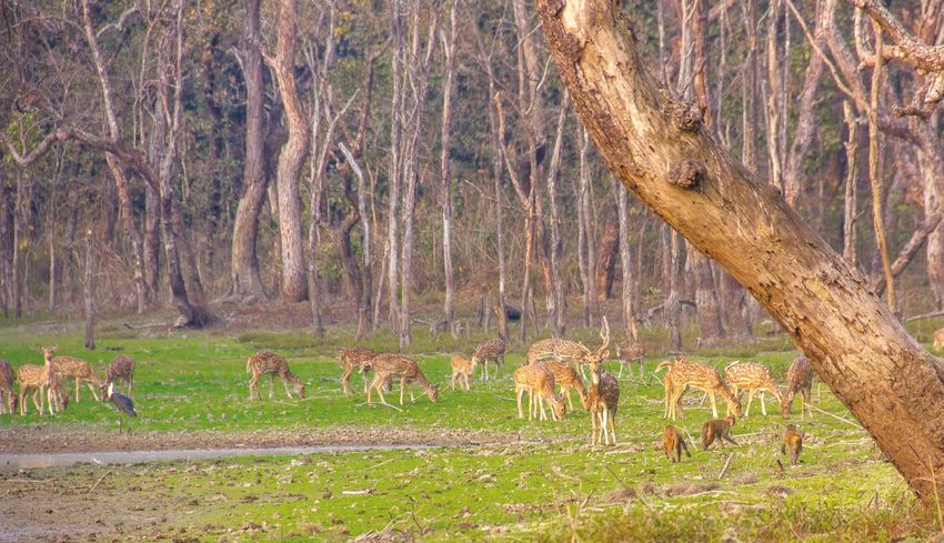
NEPAL’S CORRIDOR HISTORY
LOCAL EFFORTS, GLOBAL IMPACT
KANCHAN THAPA, SHAYASTA TULADHAR

                                                                                                                                                                       NET FOREST COVER CHANGE IN THE LAST 5 YEARS,
                                                                                                                                                                                    2015-2020 (IN HA)

                               Wildlife movement from one forested area to another is a natural process that does not adhere to                    such as forest fires, droughts, and flooding, etc. While these threats and vulnerabilities have been tackled
                               geographical boundaries: in fact, this movement is crucial for gene flow and genetic diversity. Unfortunately,      through a combination of strategic field level interventions such as protection, management, and
                               growing urbanization and development across landscapes has led to the fragmentation of forested wildlife            restoration, all guided by the Terai Arc Landscape Strategy and Action Plan, these threats and vulnerabilities
                               habitats and, today, these patches of forests are primarily contained within protected areas. Corridors,            will continue to persist if conservation efforts abate. Meanwhile, a primary emerging challenge is the
                               which include defined forested areas intermixed with grasslands and wetlands, provide connectivity                  development of linear infrastructure, with roads, highways, and irrigation canals increasingly bisecting
                               between protected areas and are integral for easy dispersal of wildlife populations in conservation                 corridors and national parks, and disrupting connectivity. Mitigation measures such as sustainable green
                               landscapes. With wildlife populations declining globally, it is imperative to prioritize or scale up restoration    infrastructure, and adequate policy framework and guidelines, will therefore be critical in maintaining or
                               efforts in corridors, particularly in large natural areas and interconnected forests.                               recreating connectivity as we move ahead.

                               Located in the shadows of the Himalayas, the trans-boundary Terai Arc Landscape stretches from Nepal’s              The two-decade long partnership with the government has yielded remarkable results, with most of the
                               Bagmati River in the east to India’s Yamuna River in the west, connecting 16 protected areas across both            corridors now functional. Today, corridor functionality as measured by wildlife dispersal, including
                               countries. Envisioned by the Government of Nepal in 2001, the Terai Arc Landscape was based on the tiger            tigers, is evident in a majority of identified corridors in the landscape—Shikaribas, Barandabhar, Kamdi,
                               dispersal model and the realization that conservation interventions within protected areas alone would              Khata, Karnali, Basanta, Laljhadi-Mohana, and Brahmadev. Meanwhile, moderate tiger genetic diversity
                               not be enough to increase the persistence of tigers in the long run. A key characteristic of the Terai Arc          estimated at 61% highlights the success of restoration efforts in corridor connectivity. A key contributing
                               Landscape, Nepal is the presence of six protected areas, eight corridors and two bottlenecks: a landscape           factor has been inclusive conservation models that prioritize the role of communities and community-
                               conservation approach that facilitates wildlife dispersal between transboundary protected areas while               based conservation in the restoration of wildlife habitats.
                               also engaging local communities in forest restoration and management.
                                                                                                                                                   However, the functionality of these habitats can easily change with variations in habitat dynamics, and the
                               Nepal currently has five protected areas dedicated to tiger conservation; however, these areas alone are            loss of these biological corridors could result in the loss of all three structural, functional, and compositional
                               inadequate in terms of sustaining tiger populations in the long term. Large investments have, therefore,            functions of the landscape. Ecosystem restoration is critical for both communities and wildlife, a fact
                               been made to secure and restore connectivity in biological corridors to achieve gene flow between                   exemplified by initiatives such as the UN’s Decade on Ecosystem Restoration (2021-2030) which aims
                               populations and avoid inbreeding depression. In the last 20 years, the Government of Nepal devised two              to halt and reverse the degradation of ecosystem across the world through massive restoration efforts.
                               landscape strategies and action plans (2004-2014 and 2015-2025) for the Terai Arc Landscape supported               Nepal’s efforts in corridor restoration are expected to complement global initiatives such as these. The
                               by conducive policies under which the community forest program and buffer zone approach were developed              functionality of these corridors today, are also owed to major flagship projects such as USAID’s Hariyo Ban
                               and implemented.                                                                                                    Program, GEF/UNDP/SNV/LIBIRD/WWF’s Western Terai Landscape Complex Project, GEF/NTNC’s
                                                                                                                                                   Tiger Rhino Project, IUCN-KFW’s Integrated Tiger Conservation Habitat Project, and numerous others
                               This publication outlines the importance of Nepal’s various biological corridors, conservation interventions,       over the last 20 years in Nepal.
                               and status in terms of functionality. It highlights the various challenges that have risen to the forefront, such
                               as habitat loss or degradation, negative human wildlife interactions, poaching, and climate vulnerabilities

4                                                                                                                                                                                                                                                                  5
Protected Area, Nepal        NP - National Park
                                                                                                                                                                             Terai Arc Landscape, Nepal   CA - Conservation Area
                                                                                                                                                                             Buffer Zone                   WLS - Wildlife Sanctuary
                                                                                                                                                                             Corridor                     TR - Tiger Reserve
                                                                                                                                                                             Protected Area [TAL India]

              Brahmadev

                     Shuklaphanta NP                                                                                                                                 CHINA
                                         Basanta
                                                   Karnali

                                                         Bardia NP
       Pilibhit TR
                            Dudhwa NP
Laljhadi - Mohana
                                                                       Banke NP
                               Katarniaghat WLS                                                                        NEPAL
                                         Khata                                                        Lamahi
                                                                                                                                                       Barandabhar

                                                              Kamdi

                                                                                        Suhelwa WLS                                              Chitwan NP

                                                                                                                                                              Parsa NP
                                                                                                                                          Valmiki TR
                                                                                                                       Sohagi Barwa WLS
                                                                                                                                              Shikaribas

                                                                                                               INDIA

   0     25          50            100             150               200
                                                                           Kilometers

  6                                                                                                                                                                                                                            7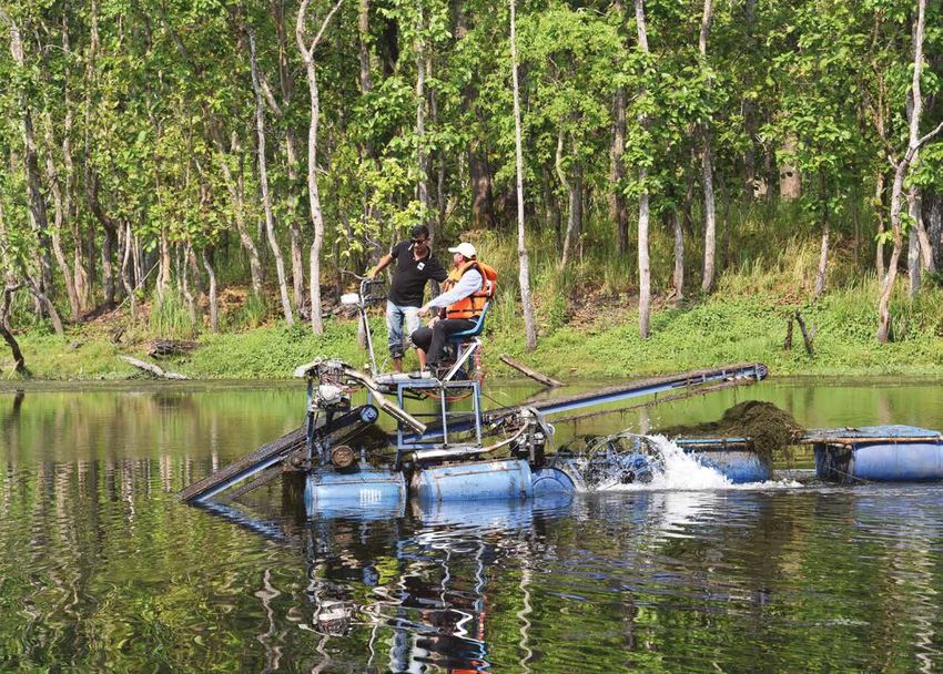
SHIKARIBAS
                                                                                                     CHITWAN NATIONAL PARK
                                                                                                     [NEPAL]

CORRIDOR
                                                                             VALMIKI TIGER RESERVE
                                                                             [INDIA]

                                                                                                        SHIKARIBAS CORRIDOR
                                                                                                                     [NEPAL]   PARSA NATIONAL PARK
                                                                                                                               [NEPAL]

CORRIDOR AREA                KEY WILDLIFE SPECIES         FOREST COVER
3.26 sq. km                  Tiger, Elephant, Leopard,    1.49 sq. km
                             Deer Species, Wild Boar

PRIMARY HABITAT TYPES        PRIMARY CHALLENGES           MAJOR RIVERS
Mixed Hardwood Forests and   Encroachment, Fuelwood       Shikaribas Khola
Grasslands                   Collection, Postal Highway

                                                                                                                                © Kamal Raj Rai/WWF Nepal

8                                                                                                                                                      9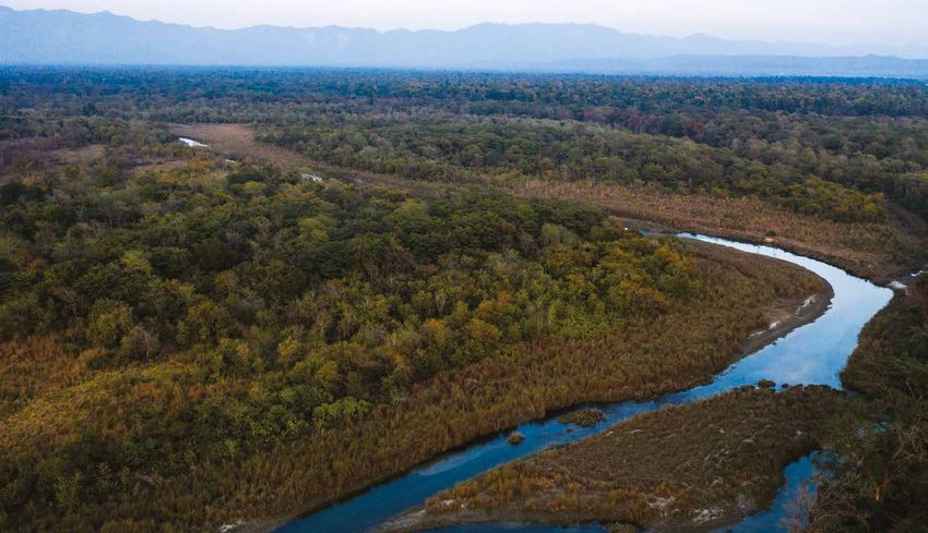
SHIKARIBAS
NEPAL’S SMALLEST CORRIDOR
KANCHAN THAPA, KAMAL RAJ RAI, SHAYASTA TULADHAR

In the winter of 2015, a local herder basking in the sun on the             a pioneer forest restoration initiative in Shikaribas Corridor that
Shikaribas bridge saw a herd of elephants at a far-off distance, swiftly    commenced in 2016. This is the second corridor after Barandabhar
marching towards the Valmiki Tiger Reserve. The elephants were              where corridor restoration in the buffer zone of Protected Areas is
moving through the narrow strip of forests, which we know today             relatively new.
as the Shikaribas Corridor. Shikaribas, which literally translates to
“hunter’s place” in Nepali is a relatively new area in the Terai Arc
Landscape, with the potential to become a functional corridor. Named
after the river Shikaribas, this is the smallest amongst the corridors in
the Terai Arc Landscape, and the only one that connects two national
parks—Chitwan National Park and Parsa National Park—in Nepal,
with the Valmiki Tiger Reserve in India. The Shikaribas river also
forms the administrative boundary between Chitwan and Parsa
National Parks in the southeastern part of the complex.
                                                                                                                                                    Forest Guard guarding the plantation site in Shikaribas Corridor                                                 © WWF Nepal/Samir Jung Thapa

The slender deciduous forest corridor measuring just over 3.26 sq. km
lies halfway between the buffer zones of Chitwan and Parsa National
Parks. This corridor is strategically placed within 3,669 sq. km of
forested area that comprises of the Chitwan-Parsa-Valmiki Complex,
and allows for the dispersal of large mammals such as tiger, elephant,
                                                                                                                                                  ENCROACHMENT, DRY SPELLS, AND                                           Moreover, the southern side of the Chitwan-Parsa-Valmiki Complex
                                                                                                                                                                                                                          lies within the Chure and Bhabar physiographic zones, where water is
rhinoceros etc. within the three transboundary protected areas.                                                                                   INFRASTRUCTURE                                                          both a limiting and regulating factor for species and their dispersal—
                                                                                                                                                                                                                          most available stream beds are seasonal in nature and the sub-
From a bird's eye view, the Shikaribas Corridor has a mosaic pattern                                                                              The Tharu people are the original inhabitants of the Shikaribas         surface remains dry most of the time. Sustaining corridor restoration
with mixed hardwood forests, dry seasonal riverbeds, and restored                                                                                 Corridor, however large-scale migration from the mid-hills and          initiatives in such conditions with continuous dry spells and climate
habitats with agricultural fields along the side. The Chitwan-Parsa-                                                                              high mountains to the Terai in the late 1950-1960's has now resulted    related risks such as droughts can therefore be challenging. Poaching
Valmiki Complex holds approximately 141 tigers, 697+ rhinoceros,                                                                                  in a more heterogeneous population inhabiting the landscape.            is another issue in the corridor and within the complex. With a shared
and 50+ migrating elephants in its three protected areas. As such,          THE SOUTHERN SIDE OF THE CHITWAN-PARSA-                               This migration led to land use conversion, with large swathes           international boundary of approximately 100 km, the southern part

                                                                            VALMIKI COMPLEX LIES WITHIN THE CHURE AND
restoration initiatives in the Shikaribas corridor are critical for the                                                                           of forested land replaced by agricultural land and settlements.         of the Chitwan-Parsa-Valmiki Complex is particularly vulnerable to
survival and wellbeing of these long ranging mammals, within the                                                                                  Furthermore, limited forest areas within the buffer zones of Parsa      illegal hunting of wildlife, especially for bushmeat as evidenced by
complex and beyond. Possibly due to its relatively small size, the
restoration of Shikaribas Corridor did not receive initial attention.
                                                                            BHABAR PHYSIOGRAPHIC ZONES, WHERE WATER                               National Park has resulted in higher pressures on the forests of
                                                                                                                                                  Shikaribas Corridor due to heavy demand for fuelwood and fodder
                                                                                                                                                                                                                          bushmeat seizures by park authorities of a variety of species such as
                                                                                                                                                                                                                          sambar, barking deer, spotted deer, and wild boar.
Periodic assessments of forest cover change however showed drastic          IS BOTH A LIMITING AND REGULATING FACTOR FOR                          from surrounding communities. As with other corridors, forest

                                                                            SPECIES AND THEIR DISPERSAL - MOST AVAILABLE
loss in forest cover between 2001 and 2015.                                                                                                       encroachment has been a significant issue, with large swathes of        The existing Postal Highway also passes through Shikaribas Corridor,
                                                                                                                                                  forest areas being cleared for agricultural practices in the buffer     with major expansion ongoing along various sections. While a part
Without conservation interventions, the ongoing trend of forest
cover loss would have resulted in diminished connectivity among
                                                                            STREAM BEDS ARE SEASONAL IN NATURE AND THE                            zone side of Parsa National Park, risking the loss of this strategic
                                                                                                                                                  transboundary connectivity. From an overall area point of view, this
                                                                                                                                                                                                                          of the existing bridge over the Shikaribas river currently acts as an
                                                                                                                                                                                                                          underpass for wildlife, further expansion of the Postal Highway in
the protected areas in the Chitwan-Parsa-Valimiki Complex.                  SUB-SURFACE REMAINS DRY MOST OF THE TIME.                             issue is particularly critical for Shikaribas given its small size in   this region could impact forests and restrict movement of wildlife
However, with concerted efforts from the government, conservation                                                                                 comparison with other corridors in the landscape.                       as traffic volumes increase.
groups and local communities, this forest loss was halted under

10                                                                                                                                                                                                                                                                                                  11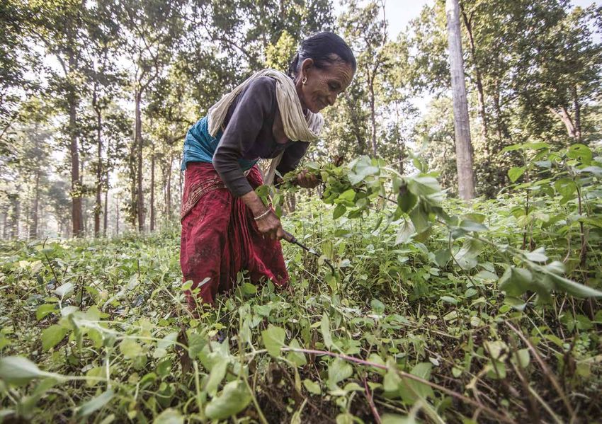
Officials from Chitwan National Park and Valmiki Tiger Reserve discuss
                                                                                                                                                           local transboundary issues at the office in Valmiki Tiger Reserve.                                                    © WWF Nepal/Prasiit Sthapit

     Villagers in Subarnapur feeding their livestock in an improved cow shed
                                                                                                                                                         As such, natural regeneration—even two years after replantation is         (BCC) classes—a voluntary peer group learning platform on various
     in an effort to reduce grazing pressure.                                                                                     © WWF Nepal/Lilu KC
                                                                                                                                                         limited, with moderate success in the survival rate of trees planted.      issues including conservation—which proved to be an effective tool
                                                                                                                                                                                                                                    in raising awareness among communities, as well as educating
                                                                                                                                                         Despite being confronted by a range of conservation issues,                them on the values of conservation. This, alongside other initiatives
                                                                                                                                                         limited knowledge on the significance of the region and inadequate         such as livestock management and stall-feeding programs, helped
TRANSBOUNDARY INITIATIVES                                                      has been the first of its kind in the landscape, supporting               knowledge on management of negative human wildlife interactions            control overgrazing and gain support for efforts, whereas promotion
                                                                               corridor restoration and survival of wildlife species in the              among local communities, resulted in a difficult start for community-      of livelihood initiatives, such as homestay promotion and skill-
Unlike other well-established corridors in the landscape, community-           transboundary complex.                                                    based conservation in the corridor. Through the IUCN/KFW project,          based trainings, helped uplift the local economy thereby fostering
based conservation was a relatively unmatured concept in the                                                                                             WWF Nepal, therefore initiated Behavioral Change Communication             community stewardship.
buffer zones adjoining Shikaribas. The Government of Nepal’s                   Conservation interventions in the Shikaribas Corridor are relatively
transformational buffer zone policy provisioned for 30-50% of park             recent as advocacy for restoration started very late in comparison
revenue to be reinvested into buffer zone communities. Unfortunately,          to other corridors in the landscape. This issue became particularly
unlike Chitwan National Park community development activities in               prominent during 2015-2016, when large areas of land were illegally
the buffer zones of Parsa National Park were relatively limited and,           encroached, and agricultural practices were in full swing. The first
therefore, communities received fewer conservation benefits. As such,          step was therefore the restoration of illegally encroached land. This
motivation for corridor conservation and restoration was relatively            was immediately followed by planting trees to support regeneration
limited among communities in Shikaribas.                                       of new forest patches, as well as fencing and changing land-use
                                                                               practices, such as grazing, to avoid any further loss of vegetation.
The opportunity for comprehensive conservation actions in                      Meanwhile, local forest guards were hired from the buffer zone
the corridor arose through an IUCN/KFW project whereby                         communities to provide protection to newly fenced regeneration
two offices—WWF Nepal and WWF India—jointly executed a                         areas. As mentioned earlier, the Shikaribas Corridor lies on a dry
transboundary project in the complex. This strategic alliance                  riverbed and replanting initiatives have been particularly challenging.

12                                                                                                                                                                                                                                                                                                             13
Tiger                                                                    Sloth Bear

     Elephant                                                                 Leopard
                                                                                                                                                                               LOOKING AHEAD
                                                                                                                                                                               In the last five years, forest restoration initiatives have resulted in a few positive signs,
Camera trap image of wildlife from Shikaribas Corridor                                                                              © DNPWC/WWF Nepal
                                                                                                                                                                               such as the improvement in biophysical conditions in Shikaribas corridor. However,
                                                                                                                                                                               there is a high chance of the corridor reverting to its degraded state if conservation
                                                                                                                                                                               interventions are interrupted. As an immediate next step, forest restoration effort
                                                                                                                                                                               needs to be prioritized with a focus on protecting forest plantation areas. Once the
                                                                                                                                                                               corridor matures with improvement in the forest tree stands, forests within the

IMPROVED FOREST COVER AND WILDLIFE DISPERSAL
                                                                                                                                                                               corridor can then be handed over to communities for management as buffer zone
                                                                              authorities. Since conservation initiatives started in 2016, local                               community forests.
                                                                              communities have once again started reporting sightings of elephant
Conservation efforts over the last five years have had a positive             herds passing through the corridor on a regular basis. Meanwhile,                                Integrated conservation and development initiatives such as homestay programs,
effect on the forests of Shikaribas Corridor. While there have                surveys have also captured tigers in self-triggering camera traps,                               livelihood enhancement activities, and stall-feeding activities etc. along with
been conservation gains, forest restoration in the corridor is yet to         confirming the use of the corridor by tigers. While the required                                 institutional capacity development will be necessary for moving ahead and preventing
compensate for the losses incurred from the impact of large-scale             forest cover for wildlife dispersal is still low, continued progress and                         regression of the corridor to its previous state. Similarly, support for youth focused
encroachment into the corridor. Periodic assessments of forest cover          positive changes in forest cover over the years will facilitate wildlife                         institutional development, such as Community Based Anti Poaching Units (CBAPU)
in the corridors show that changes in the net forest cover is still           dispersal of large carnivores through the corridor in the Chitwan-                               and eco clubs, will be critical in facilitating and maintaining mass awareness among
negative. However, while there has been no positive increase in               Parsa-Valmiki complex.                                                                           local communities. For long term sustainability of conservation interventions, it
forest cover as of yet, the degree of net forest cover loss in the corridor                                                                                                    is vital that we realize the linkages between motivation of communities, corridor
has decreased over the last five years, a sign of improvement in the          Facilitation of transboundary knowledge sharing has also resulted in                             restoration, and functionality.
biophysical conditions of the corridor.                                       communities from both sides of the transboundary complex regularly
                                                                              exchanging and sharing ideas, experiences, and knowledge that could                                 With emerging challenges such as the expansion of the existing Postal Highway that
In terms of functionality, the Shikaribas Corridor has historically           be replicated in their respective areas. These strategic initiatives are                            cuts through the corridor, it is critical that a minimal damage approach be taken—
been a migratory route for pachyderms such as rhinoceros and                  expected to improve community-based conservation in Shikaribas                                      particularly in terms of any infrastructure development within the corridor—which must
elephants, as reported by local communities and protected area                in the long term.                                                                                   adopt appropriate mitigation measures to allow for unimpeded dispersal of wildlife.
                                                                                                                                                         © Ghana S Gurung/WWF Nepal

14
CASE STUDY
WILDLIFE DISPERSAL IN SHIKARIBAS
Large mammals such as elephants, tigers and rhinoceros can disperse across long distances in a landscape. Corridors are therefore
critical for wildlife dispersal as they provide cover for safe dispersal. For instance, the Parsa-Chitwan elephant population is known
to be migratory in nature. In the summer of 2016 and 2018, large herds of elephants (as many as 15) were observed crossing over
from the Chitwan National Park side of the corridor into Valmiki Tiger Reserve in India through the Shikaribas Corridor. As the
corridor passes through settlements and agricultural fields, movement of large herds of pachyderms often places communities
on either side of the corridor at risk, leaving them vulnerable to negative human elephant interactions.
In 2019, an opportunistic camera trap survey was carried out in the forests of Shikaribas to gather photographic evidence of
wildlife presence in the corridor. This consequently led to the first photographic evidence of tigers, leopards, bears, as well as
elephants and deer species within the corridor, a testimony to conservation initiatives and functionality of the corridor with
respect to wildlife dispersal.
A comparison of camera trapped tigers in Shikaribas with other tigers camera trapped in the Valmiki Tiger Reserve consequently
resulted in a match. It was later confirmed that the same tiger from the Manguraha range of Valmiki Tiger Reserve—located
merely 8-10 km away from Shikaribas—had crossed over either to Parsa or Chitwan National Park through the Shikaribas
Corridor. Similarly, a rhinoceros was also recorded in the same range, possibly using the Shikaribas corridor to move within the
three transboundary protected areas. Such evidence clearly indicates the functionality of Shikaribas from a wildlife dispersal
point of view.
Under the leadership of respective governments, WWF Nepal and WWF India are working in close collaboration with the
common goal of increasing corridor functionality and ensuring the protection and survival of tigers and other species within
this transboundary complex. Because of its significance, the Shikaribas Corridor; is also referred to as “corridors for the future
of tigers” by IUCN/KFW.
16 plantation along Subarnapur village adjoining Shikaribas Corridor
Tobacco 17
© WWF Nepal/Samir Jung ThapaBARANDABHAR
CORRIDOR
SETI RIVER BARANDABHAR
[NEPAL] CORRIDOR
[NEPAL]
CHITWAN NATIONAL PARK
[NEPAL]
VALMIKI TIGER RESERVE
[INDIA]
CORRIDOR AREA KEY WILDLIFE SPECIES FOREST COVER
109.13 sq. km Tiger, Leopard, 99.18 sq. km
Elephant, White Rumped
Vulture, Gharial
PRIMARY HABITAT TYPES PRIMARY CHALLENGES MAJOR RIVERS AND RAMSAR SITES
Sal Forests, Wetlands, Drought, Water Pollution, Khageri, Beeshazar and
Grassland Eutrophication, River Associated Lakes
Poisioning, Encroachment,
Invasive Species, East-West
18 Highway, Railway 19
© Hariyo Ban Program, WWF Nepal/Nabin BaralBARANDABHAR
ON MIDDLE GROUND
JAGADISH CHANDRA KUIKEL, RAJESH SADA, KANCHAN THAPA, SHAYASTA TULADHAR
The Barandabhar Forest Corridor is a critical forest strip that connects Corridor hosts several wetlands and is the only remaining forest
Nepal’s two conservation landscapes—the Terai Arc Landscape in patch that connects Chitwan National Park with the Chure and
Nepal’s low-lying plains with the Chitwan Annapurna Landscape Mahabharat range, the corridor acts as a highland refuge site for wild
(CHAL) in the mid-hills and high mountains. Located between animals particularly during the periodic monsoon floods when the
Chitwan National Park in the south and the Seti River Corridor Rapti river and its tributaries overflow into the low-lying floodplain
and Mahabharat range in the north, the corridor covers an area of areas, as well as during other erratic weather conditions.
109.13 sq. km. Barandabhar is one of the first corridors in Nepal
where restoration initiatives began in the 1990s implemented by the The Barandabhar forest corridor is reported to be home to over
National Trust for Nature Conservation (NTNC). 32 species of mammals, 329 species of birds, 37 species of fishes,
and 45 species of herpetofauna. Its rich biodiversity in terms of
Barandabhar corridor is one the few corridors in the Terai wildlife, forest coverage, and wetlands have consequently led
to host wetlands of international importance—Ramsar sites to its delineation as one of the country's 32 Important Bird and Riverbank cutting protection measures upstream of Khageri River © Rajesh Sada/WWF Nepal
such as the Beeshazar and Associated Lakes. Besides being Biodiversity Areas. Meanwhile, core areas of the corridor; north of
rich in biodiversity, the corridor also provides significant the East-West highway, was designated as a Forest Conservation
ecological services. For instance, water from these lakes
and the Khageri Irrigation System supports irrigation of
Area (formerly Protected Forest) in 2011. Under this system, the
corridor falls under the jurisdiction of the Chitwan Divisional Forest
CHALLENGES AND VULNERABILITIES consequently negatively impacts water levels in the Beeshazar Lake.
Equally, the lake also faces serious problems from eutrophication
39 sq. km of agriculture lands, regulates flooding, and recharges Office, whereas the area south of the highway is designated as a buffer and proliferation of invasive species which significantly affects the
groundwater for the western Chitwan area. As the Barandabhar zone forest and is under the jurisdiction of Chitwan National Park. Despite the critical value of the corridor, the forests and wetlands wetlands health.
of Barandabhar are under serious pressure from illegal timber
collection, inappropriate land use, and forest encroachment due Likewise, poorly planned infrastructure development—inside as
to increasing urbanization in its surrounding cities—Kalika and well as outside the corridor—pose new challenges, altering natural
Ratnanagar Municipalities in the east and Bharatpur Metropolitan ecologies along the upstream and downstream areas. Habitat
City in the west. An assessment of biodiversity threats and climate destruction upstream in the form of forest encroachment—although
change vulnerability in 2012, indicated a “Very High” threat rating at a low scale—can have direct environmental impacts downstream.
for Barandabhar Corridor, with challenges arising from climatic For instance, the relatively dry upstream areas of Chure and Bhabar
and non-climatic risks, unpredictable rainfall patterns, drought, may become more vulnerable to forest fires or droughts during
water pollution, eutrophication, proliferation of invasive species, the dry seasons. Meanwhile, downstream, communities may face
and infrastructure development. greater likelihoods of floods, riverbank cutting, and sedimentation
during the monsoons. Similarly, intensification of agriculture in the
Uncertain rainfall patterns often result in either too little or too upstream areas also results in increased flow of chemical effluents,
much rainfall, leading to drought, drying up of water sources, forest triggering proliferation of invasive species in wetlands downstream.
THE BARANDABHAR FOREST CORRIDOR IS REPORTED TO BE HOME TO OVER 32 SPECIES OF MAMMALS, 329 fires, landslides in the hill slopes of Chure, flash floods, riverbank
cutting, or sediment deposits in the downstream areas. Degradation
Meanwhile the East-West Highway, Narayanghat-Mugling Highway,
Khageri Irrigation Canal, and a new roadway to the Padampur
SPECIES OF BIRDS, 37 SPECIES OF FISHES, AND 45 SPECIES OF HERPETOFAUNA. in the upstream watershed area, increase of sediment load in water
bodies, and sediment deposits due to landslides and soil erosion
settlement relocated outside Chitwan National Park also fragments
the Barandabhar corridor in different areas, severely hindering
reduces water flow into the Khageri Irrigation Canal, which north-south dispersal of wildlife.
20 21INTEGRATED SUB-WATERSHED MANAGEMENT As a critical climate refuge site, one of the focused conservation interventions is protection and management of this critical sub- watershed. The Integrated Sub-Watershed Management Plan of Khageri Khola sub-watershed prepared with support from USAID’s Hariyo Ban Program in 2017 focused on increasing the productivity and utility of land and water resources for biodiversity conservation and livelihood promotion through an integrated watershed management approach while maintaining upstream and downstream linkages. Initiatives in the upstream areas are primarily focused on reducing forest encroachment, degraded land rehabilitation, riverbank protection, and water source protection including ground water recharge. The 18 wetlands located within the Barandabhar Corridor have been the focus of conservation through restoration efforts such as removal of invasive species, construction or maintenance of dykes and outlets, extraction of deposited sediments etc. Six new lakes have been created within this narrow strip of forest corridor to increase water storage capacity during monsoons, regulate flooding, replenish groundwater in the region and improve the habitat for terrestrial and aquatic biodiversity. Meanwhile, initiatives downstream focus on grassland and invasive species management, and water source management for wildlife. The Integrated Sub-Watershed Management Plan also engages multiple stakeholders and addresses a myriad of climatic and non-climate threats, which complement conservation efforts to maintain the functionality of the Barandabhar Corridor. LEVERAGING COMMUNITIES Over the past three decades, WWF Nepal along with conservation stakeholders, and under the leadership of the Government of Nepal has undertaken a wide range of corridor and wetland restoration initiatives in the Barandabhar Corridor. Community engagement was a critical factor here and a diverse assortment of interventions were undertaken with the aim of generating community buy-in. For instance, building community awareness through media, street drama, and early education programs; and community empowerment and livelihood diversification through capacity building, skill-based trainings as well as on-farm and off-farm based activities such as honey production, wool weaving, dairy, off-farm vegetable production, and goat/pig rearing. These initiatives helped raise awareness among communities helping to diversify their annual income streams alongside reducing stress on natural resources. Livelihood support, leveraged through provision of revolving funds spurred community members to participate in conservation activities such as tree plantations, fencing, control of livestock grazing and forest fires, prevention of illegal extraction of forest resources, and anti- poaching initiatives. Meanwhile, Community Based Anti-Poaching Units Communities piloting Nepal's first water mower machine (CBAPU) were mobilized to deter poaching of wildlife and illegal harvest - Gokaarno, in Beeshazar Lake of forest products. © WWF Nepal 22 23
Leopard                                                                     Rhino

  Tiger                                                                       Sloth bear
                                                                                                                                                                                LOOKING AHEAD
Camera trapped pictures of wildlife from Barandabhar Corridor                                                                         © DNPWC/NTNC
                                                                                                                                                                                In the last 20 years, net forest cover within the corridor has increased by
                                                                                                                                                                                1.28 sq. km, while over 72,000 households living on either side of the corridor have
                                                                                                                                                                                benefited through various conservation and development initiatives. Transformative
                                                                                                                                                                                conservation polices and approaches such as the community forestry program and
                                                                                                                                                                                buffer zone concept have been a turning point, not only for the corridor but the
THRIVING FORESTS AND COMMUNITIES                                              of new wetlands inside the forest have shown clear results in
                                                                              reducing negative human wildlife interactions and increasing
                                                                                                                                                                                Terai Arc Landscape as a whole. Meanwhile, embracing the concept of integrated
                                                                                                                                                                                conservation and development, through flagship projects such as the NTNC led Global
“The Barandabhar Forest Corridor used to be so degraded in the past           groundwater levels in nearby settlements.                                                         Environment Facility (GEF) project, and USAID’s Hariyo Ban Program, has helped
that one could see the settlements on either side of the corridor”, recalls                                                                                                     transform the Barandabhar Corridor, linking Chitwan National Park to the broader
Dr. Shant Raj Jnawali, renowned rhino biologist. The degradation              Gaurs are one of the largest species of wildlife found in Chitwan                                 Mahabharat Range, thereby benefiting forests, wildlife, and communities.
and deforestation in the corridor were acute in the 1990s, so much            National Park; primarily moving within the higher elevation Chure
so that renowned tiger biologist Dr J. L. Dvavid Smith, expressed             forests in the south. However, a few of these bovines were recently                               Looking ahead, conservation practices must continue to prioritize upland watershed
his concerns on the fate of the corridor’s forests. The forests were          found recolonizing forest habitats along the northern Chitwan                                     protection to minimize degradation of critical wetland ecologies and climate
so degraded that one could view the East-West Highway from one                Valley including the Barandabhar Corridor. Experts have hinted                                    refuge sites. Approaches such as Integrated Watershed Management that takes
end of corridor.                                                              that this recolonization is possibly due to high level degradation                                into consideration upstream and downstream linkages and maintains biodiversity
                                                                              and disturbances within the Chure habitat. This recent finding;                                   conservation and community wellbeing at its center, will be critical.
Continuous support and engagement in the corridor these                       though unverified, acts as a preliminary example on the potential
past 20 years, have visibly reduced the overwhelming threats to               value of Barandabhar as a long-term micro refuge site. Meanwhile,                                 A spate of new challenges have also arisen for the corridor, with booming urbanization,
Barandabhar’s ecosystem and biodiversity. The improved health of              the corridor also provides habitat for large mammals such as tigers,                              industrialization, and development of linear infrastructure. Construction of roadways
forests, grasslands and wetlands, have helped the corridor become             rhinoceroses, and elephants. For instance, recent surveys show a                                  in upstream regions, and expansion of highways and proposed railway construction
functional once again, supporting wildlife dispersal, including during        minimum of four tigers using the Barandabhar corridor. Likewise,                                  in the lower part of the corridor are of particular concern. Placement of strategic and
extreme weather events. Community sightings and surveys indicate              regular wildlife monitoring in Barandabhar Corridor by the NTNC                                   timely mitigation measures such as the construction of overpasses and underpasses,
that a variety of species—mammals including tiger and rhinoceros,             shows high use of habitat by a suite of wildlife such as leopards,                                regulation of vehicular traffic, etc., will need immediate attention in the days ahead.
and birds—are increasing in the region. While negative human                  civets, deer species in the forest, and gharial and mugger crocodiles                             While any form of construction causes damage to the natural environment; tackling
wildlife interactions in the form of crop depredation and livestock           in the river and wetlands, indicating high corridor functionality with                            them strategically and adopting a minimal damage approach to natural resources,
killings is still an underlying issue in nearby communities, proactive        respect to wildlife dispersal.                                                                    can safeguard both the environment and human wellbeing.
interventions such as fencing have succeeded in reducing their
frequency. Likewise, wetland restoration efforts and construction                                                                                      © Ghana S Gurung/WWF Nepal

24
CASE STUDY
WILDLIFE UNDERPASSES AT BARANDABHAR CORRIDOR
Increasing wildlife mortality due to vehicular collisions are a growing concern in Nepal, particularly along highways that traverse
national parks and corridors. Such incidents of Vehicular Wildlife Collisions present immense challenges, as the Barandabhar
Corridor is the only remaining forest in Chitwan that provides north-south habitat connectivity for wildlife dispersal between
Chitwan National Park and the mid-hills and mountains in the north.
To alleviate these challenges, the Department of Roads constructed four underpasses in 2016 to facilitate wildlife mobility across
the Narayanghat-Mugling Highway, that bisects the Barandabhar corridor. Six km of the 35 km highway currently passes through
the dense forests of the corridor, increasing wildlife susceptibility to Vehicular Wildlife Collisions.
In 2017, WWF Nepal monitored the movement of wildlife over a year using camera traps to determine the effectiveness of these
underpasses. The results were encouraging, with over 15 mammal species–such as the common leopard, wild boar, jungle cat,
common palm civet, deer, monkey, etc. found to be using the underpasses regularly. According to the Divisional Forest Office in
the region, incidents of vehicular wildlife collisions involving wildlife plummeted significantly since the underpasses and guiding
fences were introduced along highway sections.
Such examples of underpasses coupled with guiding fences prove that wildlife friendly infrastructure is a distinct possibility for
Nepal as we move towards rapid development. These mitigation measures are effective in minimizing vehicular wildlife collisions
and should be prioritized while upgrading and developing new highway sections crossing through national parks, corridors,
critical watersheds and habitats in Nepal.
26 27
Barandabhar corridor hosts one of the highest density of spotted deers in Nepal's corridors © Karun Dewan/WWF NepalLAMAHI
BANKE
NATIONAL
PARK
CORRIDOR
[NEPAL]
LAMAHI CORRIDOR
[NEPAL]
SUHELWA
WILDLIFE
SANCTUARY
[INDIA]
CORRIDOR AREA WILDLIFE SPECIES FOREST COVER
243.74 sq. km Hyena, Elephant, Leopard, 146.25 sq. km
Deer Species
PRIMARY HABITAT TYPES PRIMARY CHALLENGES MAJOR RIVERS
Mixed Hardwood Forests Deforestation, Overgrazing Rapti
and Sal Forests
28 29
© Muna Thapa/WWF NepalLAMAHI
GOOD GOVERNANCE AND FOREST RESTORATION
KANCHAN THAPA, DHAN RAI, SHAYASTA TULADHAR
Lamahi Bottleneck Forest is one of three bottlenecks in the Terai Arc Conservation interventions in Lamahi started in 2001 through the
Landscape—Lamahi, Mahadevpuri, Dovan—considered critical for Corridor and Bottleneck Restoration Project, implemented by the Degraded forest habitats Pressure on forests for fuelwood
restoring forest connectivity. Nestled within the Chure range, the Government of Nepal and WWF Nepal under its Terai Arc Landscape
Lamahi Bottleneck Forest covers an area of 243.74 sq. km, joining Program. Communities were initially averse to the concept of the
large forest blocks on either side facilitating forest connectivity in Terai Arc Landscape, since they believed its aim was to create
the landscape. The western part of the forest block connects with protected areas that would curtail their access rights to natural
Banke National Park, the eastern part with Chitwan National Park, resources. With the Lamahi Bottleneck Forest heavily degraded
and the southern part with the extended forests of Kamdi Corridor. with only sporadic patches of forest in between, forest restoration
was the first and primary conservation focus through strengthening
The forests of Lamahi form a part of the Deukhuri Valley, which is of community institutions. Prior to 2001, 19 Community Forests
also an important bird area (IBA) due to its forest conditions, water (CFs), measuring ~1100 ha, had already been formed and handed
availability, and proximity to national parks. Lamahi’s forests along over to communities to support restoration initiatives as well as
the Chure foothills in the Terai Arc Landscape make up a historic empower community-based organizations by enhancing livelihood
migration route for wild elephants in the country. In the past, wild opportunities and promoting good governance practices.
elephants from Banke National Park were known to use these forests
to travel up till the northern side of Kapilvastu. The region is an Under the leadership of the Community Forest Coordination
important reservoir for groundwater and has been identified as a Committee (CFCC)—a loose network of Community Forest User
critical and strategic site for forest restoration to facilitate wildlife Groups (CFUG) that work primarily in natural resource governance—
dispersal within the Terai Arc Landscape communities thereby initiated programs to deal with common issues
Illegal settlements inside Lamahi, Degraded forest habitats Dry stream bed in Lamahi Corridor.
such as encroachment, illegal logging, grazing pressures, etc. At the
same time, the CFCC’s also worked towards strengthening their © Simon de TREY-WHITE / WWF-UK
institutional operations, transparency, and accountability towards
CONSERVATION EFFORTS stakeholders. Sustainable livelihood initiatives and alternate energy
programs through biogas and improved cooking stoves financed
Once rich in forest resources, the area subsequently became heavily
using micro-credit were also introduced to reduce household
dependence on natural resources and diversify income opportunities.
governance, Department for International Development (DFID) in
Non-Timber Forest Product (NTFP) cultivation, biogas companies
PARTNERSHIPS AND RESOURCE LEVERAGING
deforested due to illegal logging and open grazing of cattle, particularly Improved community stewardship through various such programs in biogas construction etc. As such, partnerships and resource THROUGH COMMUNITY ENGAGEMENT WITH
DEVELOPMENT AGENCIES HAVE HELPED BRING IN
during the 1950’s following large-scale migration of communities consequently helped address challenges such as increase in forest leveraging through community engagement with developmental
from the hilly regions into Terai’s lowland areas. During this time, fires, poaching and negative human wildlife interactions. agencies have helped bring in added financial, technical, and
the forests within Dang Valley, including Lamahi, faced large-scale
deforestation as communities took over forested land to engage in Similarly, partnerships with specialized I/NGOs and other
managerial resources towards ongoing forest restoration initiatives.
Collectively, over 385,000 people have benefited from various forest
ADDED FINANCIAL, TECHNICAL, AND MANAGERIAL
agricultural practices, which led to grazing pressures that limit natural government line agencies have been a key factor for conservation restoration, institutional development, and livelihood-related RESOURCES CONTRIBUTING TOWARDS ONGOING
FOREST RESTORATION INITIATIVES.
regeneration and forest growth. Additionally, the construction of initiatives in Lamahi. Through these partnerships, a range of interventions in the Lamahi Bottleneck Forest since 2001.
the East-West Highway, popularly known as Mahendra Highway, developmental issues such as access to clean drinking water, primary
during the 60’s led to further fragmentation of large-scale forest healthcare, education, governance etc. has been addressed. For
patches. Growing urbanization around the region subsequently led instance, agencies such as United Nations Development Program-
to an increased demand for fuelwood from market centers such as Micro-Enterprise Development Programme (UNDP-MEDEP) have
the Lamahi Bazaar, which was then met though timber from the been involved in developing livelihood skills, CARE Nepal in good
nearby forests.
30 31Honey Badger Leopard Striped Hyena
Camera trapped pictures of wildlife from Lamahi Bottleneck Forest © Chiranjeevi Khanal The Lamahi Bottleneck area, before and after restoration © WWF Nepal
IMPROVED BIOPHYSICAL CONDITIONS sources and wells, meeting forest product needs sustainably through LOOKING AHEAD Over the last 20 years, forest restoration efforts have helped re-
their community forests, planting and harvesting various NTFPs, etc. develop a mosaic of wetlands, grasslands, and forested areas,
AND SPECIES RECOVERY It is safe to say that the Lamahi Bottleneck Forest is no longer a suitable for wildlife dispersal, as well as provided access to forest
Improved forest conditions also facilitated the recovery of wildlife bottleneck, as successful implementation of forest restoration resource among communities. The corridor forest restoration model
Over the last 20 years, net forest cover in the Lamahi Bottleneck in the region with camera trap evidence of 23 species of wildlife, initiatives over the last two decades have brought about remarkable in Lamahi showcases the importance of government leadership,
Forest has increased by almost 9.18 sq. km with completely including leopards and hyenas in the area. Likewise, communities changes, evident through its regenerated forest cover; and thriving community stewardship, good governance and leveraging
deforested regions now flourishing, demonstrating the impact of have also observed the recovery of different species of vultures in wildlife populations. This process has consisted of long-term partnerships and finances, thereby carrying the potential for
forest restoration initiatives in the Chure hills. During this time, the area. investments, local political will (homogeneous communities), replication in other critical sites. However, external factors such
the Terai Arc Landscape Program facilitated the plantation of and support from communities (cohesiveness). Cultural beliefs of as growing Lamahi market centers, village road construction,
roughly 0.85 million units of native tree and shrub species in the In 2004, a herd of elephants were seen migrating along their communities such as the Rakhauna system in the early days—which expansion of existing highways, and sand and gravel extraction in
Lamahi Bottleneck Forest. New community forests were also formed historical routes which also passes through the Lamahi Bottleneck states that one should preserve natural resources for future and use Chure may exert additional pressure on forest resources, as well
bringing a majority of forest areas in Lamahi under community- Forest, pausing briefly at a large conservation pond situated at the it sustainably—have obliged local communities to use and protect as increase the likelihood of negative human wildlife interactions.
based management. foothills of Lamahi. Many such incidences have also been recorded natural resources in a wise and sustainable manner. Meanwhile, Continuous engagement, collaboration and dialogue among the
by communities in the past. While large carnivores such as tigers natural calamities such as unexpected cloud bursts and periodic concerned stakeholders will, therefore, be key moving ahead.
A visible impact of reforestation efforts and improved forest and leopards were historically known to move through these forests, flooding in the region have further driven communities to adopt
conditions has been on the recharge of underground water and camera trap evidence of a male tiger in the northern part of Kapilvastu forest restoration and climate adaptation initiatives. These coupled
spring sources, in a region otherwise faced with periodic dry spells, district, 40 km east of Lamahi was officially recorded, according to with time-specific conducive government policies such as community
benefiting both communities and wildlife. With forests aiding the a 2021 Chure survey report published by National Trust for Nature forest programs have been conducive to Lamahi’s forest recovery.
process of natural regeneration of groundwater, local communities Conservation. The probable site from which this tiger dispersed is
have benefited from irrigation facilities that contribute to considered to be Banke National Park due to its proximity, with the
their agricultural livelihoods. For instance, in 2014 the Kalapani tiger traveling through two possible routes—the Chure foothills in the
forest within Lamahi, was declared as a zero-grazing site by the Lamahi Bottleneck Forest or the Chure foothills of Kamdi Corridor.
local CFUG. Today, communities enjoy various benefits from their
conservation initiatives such as access to drinking water from springs
32 33CASE STUDY
FOREST, WATER, WILDLIFE, AND COMMUNITIES
The Kalapani community forest is a 19.5 sq. km forest block located within the Lamahi Bottleneck Forest. This community forest
has had good forest coverage, perennial sources of water through its river channels and high usage of its forests by wildlife. The
community forest is also a historical migratory route for elephant dispersal across lowland areas, with communities having
observed occasional visits from large pachyderms in the past. Prior to 2001, the Kalapani community forest was highly degraded,
with wide scale pressure from livestock overgrazing, illegal timber felling, etc. exposing the red soil underneath.
Forest restoration initiatives by both communities and the divisional forest office have, however borne fruit over the last 20
years, with stark improvements in forest cover and forest condition, offering multiple benefits for wildlife and communities. For
instance, one of the small spring sources within Kalapani has increased to almost 500 m2, from just 5-10 m2 previously, holding
approximately 1,000 m3 of water. The water source is now used for irrigation and drinking by downstream communities.
“We have been able to protect and conserve this small spring source which has now grown into a big conservation pond. The
water has been critical in vegetable farming” states Baliram Chaudhary, President of the Kalapani CFUG. Our results show that
these households earn approximately USD 1,230 annually from the sale of fresh seasonal vegetables in nearby market centers.
“CFUGs are now finally seeing the benefits of conserving these forests as our active efforts have been showing results” stresses
Chaudhary. Over 300 households; primarily from the indigenous Tharu communities, are now direct beneficiaries from the
Kalapani Community Forest.
Chiranjeevi Khanal, an enthusiastic wildlife biologist from Dang district, states “Hyena, barking deer, and civets are now resident
wildlife in these forests”. Forest cover in the Kalapani community forest has increased by 12 sq. km in the last 20 years, with
documented evidence of wildlife recovery, thereby showcasing the nexus between forest cover, groundwater recharge, and wildlife
recovery, as well as the well-being of communities.
34 35
Community member weeding wildlife deterrant mint crops in Lamahi © Simon de TREY-WHITE / WWF-UKKAMDI
BARDIA
NATIONAL PARK
[NEPAL]
CORRIDOR BANKE
NATIONAL PARK
[NEPAL]
KAMDI
CORRIDOR
SUHELWA
WILDLIFE
SANCTUARY
CORRIDOR AREA KEY WILDLIFE SPECIES FOREST COVER [INDIA]
667.36 sq. km Elephant, Tiger, Leopard, 524.41 sq. km
Hyena, Sloth Bear, Sambar
Deer, Leopard Cat, Gharial
PRIMARY HABITAT TYPES PRIMARY CHALLENGES MAJOR RIVERS
Sal Forests, Mixed Hardwood Overgrazing, Fuel Wood Rapti
Forests, Floodplain Grasslands Collection, Poaching, Droughts,
Sand and Gravel Mining, Postal
Highway, Irrigation Canals
© Ghana S Gurung/WWF Nepal
36
© Muna Thapa/WWF NepalKAMDI
CONSERVATION AMIDST CHALLENGES
KAPIL KHANAL, KANCHAN THAPA, SHAYASTA TULADHAR
Kamdi, the largest corridor in the Terai Arc Landscape, stretches Some regions within the corridor such as Chure and Bhabar are
across an area of 667.36 sq. km from Dang district to Banke National however considered highly climate sensitive zones characterized by
Park in the mid-western region of Nepal. Linking Banke National dry lands facing extreme weather events such as prolonged droughts
Park in Nepal and Suhelwa Wildlife Sanctuary in India, Kamdi is of and floods and have poor water retention capacity. An assessment
utmost importance for the conservation of megafauna such as tigers of biodiversity threats and climate change vulnerability in 2012,
and elephants. The region is a priority complex for tiger recovery and indicated a “Very High” threat rating for Kamdi Corridor with forest
spillover tiger populations from the high-density tiger site of Bardia fires, poaching, deforestation, grazing, poorly planned infrastructure
National Park. development, and droughts as the primary challenges.
Initially known as the Mahadevpuri Bottleneck Area, the area was WWF Nepal started working in Kamdi Corridor with support from
renamed Kamdi after the establishment of Banke National Park. The the Save the Tiger Fund, which focused on linking forest restoration
Kamdi Corridor represents a mosaic of three major physiographic with tiger recovery and community benefits. The basic premise was
zones of Nepal—Chure, Bhabar and Terai flood plains—facilitating the presence of wildlife in the region as a catalyst for conservation
north-south linkage for wildlife dispersal. While the corridor faces efforts; and rewarding communities in cash for the presence of
diverse social, ecological, and infrastructural challenges, it holds wildlife in their area. However, this cash remuneration model was
considerable conservation significance as a dispersal pathway and later changed into a grant model due to compliance issues.
as a provider of ecological services through regulation of water
availability in the landscape. Additionally, the floodplains of the
Rapti river, which passes through the corridor, are also prime
habitats for the critically endangered gharial. Bridge over a Sikta Irrigation Canal in Kamdi Corridor © Muna Thapa/WWF Nepal
With Kohalpur in the north and Nepalgunj in the south of the
CHALLENGES WITHIN THE COMPLEX corridor—both cities facing rapidly increasing population and mass
urbanization—the subsequent increase in consumptive demands
The dense forests of Kamdi Corridor formerly provided a rich resulted in increased pressures on the forests in the region. With
habitat for wildlife as well as fuelwood and fodder for local the updated protection status of Banke National Park—established
communities. However, a major flooding of the Rapti river in 2006 in 2010, the booming demand for forest resources from the growing
left the region inundated, and in its aftermath large swathes along neighboring cities fell disproportionately on the Kamdi Corridor
the fringes of Chure were converted into temporary settlements located south of the national park. Forest loss and fragmentation
for flood victims. Encroachment into the corridor only increased were further exacerbated by large infrastructure development
following the flooding of the Rapti in 2014, 2015 and 2017, further such as construction of irrigation canals and postal highways
aggravating forest degradation and loss in this corridor. Community running through the corridor as well as expansion of the East-West
forests in the corridor were hit hard with increased pressure on Mahendra Highway.
forest resources, overgrazing, and gradual escalation of illegal
activities, such as illicit harvesting, timber felling, and poaching.
Consequently, large patches of grasslands and forests gradually
transformed into settlements.
38 39You can also read