Consumer and Commercial Drones - How a technological revolution is impacting Irish society
←
→
Page content transcription
If your browser does not render page correctly, please read the page content below
Consumer and
Commercial Drones
How a technological revolution is
impacting Irish society
No. 1 of 2021
Dr. Boris Galkin, Trinity College Dublin, SFI Researcher-in-
Residence
10 February 2021

Abstract
This Spotlight examines the emerging technology of drones and
their rapid proliferation into the consumer and commercial
sectors. At the time of writing, drones are being adopted by a
variety of organisations and industries worldwide, with wide-
ranging consequences. This paper provides an overview of
drone technology, including its future trends. It also explores
examples of the real-world impact of drone use and the
evolving legislation governing drones in Ireland.
Library & Research Service | Consumer and Commercial Drones 1
Contents
Glossary ......................................................................................................................................... 3
Executive Summary ........................................................................................................................ 5
Introduction ..................................................................................................................................... 7
1. Principles of Drone Operation ................................................................................................. 8
1.1 Drone Types ......................................................................................................................... 8
1.2 Drone-Pilot Communication Link ........................................................................................... 9
1.3 Drone Artificial Intelligence .................................................................................................. 11
1.4 Drone Cameras ................................................................................................................... 15
1.5 Anti-Drone Measures .......................................................................................................... 16
2. Technological Developments ................................................................................................ 22
2.1 Communication Link Improvements .................................................................................... 22
2.2 Flight Time Improvements .................................................................................................. 25
2.3 Drone Artificial Intelligence Improvements........................................................................... 26
3. Real Life Applications of Drone Technology .......................................................................... 29
3.1 Photography and Filmmaking .............................................................................................. 29
3.2 Emergency Services and Law Enforcement ........................................................................ 30
3.3 Infrastructure Inspection and Surveying .............................................................................. 31
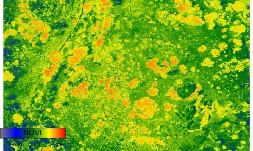
3.4 Smart Agriculture and Environmental Monitoring ................................................................. 33
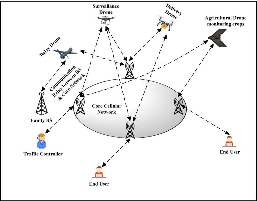
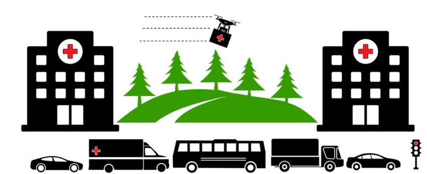
3.5 Delivery and Transportation ................................................................................................ 35
3.6 Telecommunications ........................................................................................................... 38
3.7 Recreational Use................................................................................................................. 39
3.8 Illegal Uses ......................................................................................................................... 40
4. Regulations on Drone Use .................................................................................................... 42
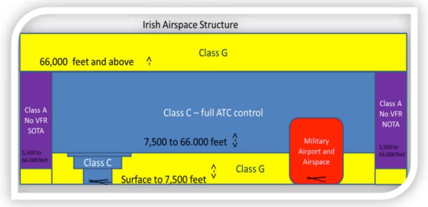
4.1 Controlled and Uncontrolled Airspace ................................................................................. 42
4.2 Prior Regulations on Drone Use .......................................................................................... 43
4.3 Current EU Regulations on Drone Use ................................................................................ 46
4.4 U-Space and Drone Air Traffic Management ....................................................................... 51
4.5 GDPR and Drone Camera Recordings ................................................................................ 53
4.6 Drone Use in Sensitive Areas.............................................................................................. 56
4.7 Role of An Garda Síochána and the Irish Air Navigation Service ........................................ 57
Conclusion .................................................................................................................................... 58
Library & Research Service | L&RS Spotlight                                                                                      2

This L&RS Spotlight may be cited as:

Oireachtas Library & Research Service 2021, L&RS Spotlight: Consumer and Commercial Drones - How a
technological revolution is impacting Irish society

Legal Disclaimer
No liability is accepted to any person arising out of any reliance on the contents of this paper. Nothing herein constitutes
professional advice of any kind. This document contains a general summary of developments and is not complete or
definitive. It has been prepared for distribution to Members to aid them in their parliamentary duties. Some papers, such
as Bill Digests are prepared at very short notice. They are produced in the time available between the publication of a Bill
and its scheduling for second stage debate. Authors are available to discuss the contents of these papers with Members
and their staff but not with members of the general public.

A number of companies/organisations/entities are referenced in this document by the author. These references are
provided for illustrative purposes; are not exhaustive; and do not constitute an endorsement of these
companies/organisations/entities or their products.

This document was prepared using unclassified material available to the general public and does not provide insight on
issues of Irish State security. The author is not affiliated with any law enforcement organisation, state military or military
research body.

© Houses of the Oireachtas 2021

Acknowledgements
The author would like to thank Dr. Etaoine Howlett, Ms. Maria Fitzsimons and Mr. Ivan Farmer of
the Oireachtas Library & Research Service for their work as internal QAs on this paper. The author
would also like to thank Ms. Julie Garland of Avtrain, Mr. Dennis McNulty and Dr. Tom O’Dea of
CONNECT, as well as Capt. Lou Fine of the Irish Aviation Authority for their assistance as external
QAs. Finally, the author would like to thank Mr. Darren Lawlor of the Oireachtas Library &
Research Service for assistance with the graphical content of this paper and Dr. Anna Jackman of
the University of London for her guidance with regards to the preparation of this document.

   This publication has emanated from research supported in part by a research grant from Science
   Foundation Ireland (SFI) under Grant Number 19/PSF/7615.

   The author, Dr. Boris Galkin, produced this publication whilst Researcher-in-Residence at the
   Oireachtas Library & Research Service and is available to discuss his work on drone technology
   with interested parties. Dr. Galkin may be contacted at the CONNECT Centre, Trinity College
   Dublin at galkinb@tcd.ie. CONNECT is the world leading SFI Research Centre for Future Networks
   and Communications. It is co-funded under the European Regional Development Fund.
Library & Research Service | Consumer and Commercial Drones                                             3

Glossary
This section sets out a number of definitions for the purpose of this L&RS Spotlight.
5G: is a family of mobile phone network technologies and standards which are currently being
adopted by network operators worldwide.
ATC (Air Traffic Control): is the authority that monitors aircraft while in flight and ensures their
safety by providing flight guidance and instructions.
AI (Artificial Intelligence): is the software on a drone that allows it to operate automatically or
autonomously.
Automatic flight: is a type of drone flight where the AI is piloting the drone, with the pilot
supervising and taking manual control if necessary.
Autonomous flight: is a type of drone flight where the AI is piloting the drone, and the pilot is not
able to intervene and take manual control.
Beyond Visual Line-of-Sight (BVLOS): refers to drone flight where the device flies beyond the
point where the drone pilot can see it with the naked eye.
Controlled airspace: refers to airspace that can only be accessed by aircraft with prior approval
from ATC.
Drone: refers to a flying machine that does not have a pilot on-board.
Drone operator: refers to the legal owner of a drone.
Drone pilot: refers to the person responsible for the safe and successful flight of a drone. The pilot
sends flight instructions to a drone during its operation and receives flight information back from
the drone.
EASA (European Union Aviation Safety Agency): is the European Union (EU) agency
responsible for civilian aviation safety.
Fixed-wing drone: refers to a type of drone that resembles an aeroplane (i.e. with two wings).
Geofencing: refers to a safety function that prevents a drone from entering a certain area, based
on Global Positioning System (GPS) coordinates.
GDPR (General Data Protection Regulation): is a set of EU regulations on the gathering,
processing, and use of personal data.
GPS (Global Positioning System): is a technology that allows a device to identify its exact
location using signals sent from satellites.
IAA (Irish Aviation Authority): is the state-owned company responsible for regulating the use of
Irish airspace, and the lawful operation of drones in the country.
IMU (Inertial Measurement Unit): are a group of sensors that measure how a drone is moving
and how it is positioned while in flight.
Interference: refers to a loss of radio signal quality which arises when multiple devices are
transmitting on the same frequency band, causing a “collision” of signals.

Library & Research Service | L&RS Spotlight                                                            4

LOS (Line-of-Sight): is when a radio signal transmitter and receiver can “see” one another,
because there are no obstacles directly between them.
Manned aviation: refers to flights carried out by aircraft which have human pilots (and possibly
human passengers) on-board, such as commercial jet airliners.
Meteorology: refers to the study of the atmosphere, including weather forecasting. In the context
of aviation, it refers specifically to the topic of how weather affects flight performance.
Model aircraft: refers to a type of remote-controlled toy aircraft that is modelled after real-world
vehicles. These are typically flown by hobbyists in dedicated model aircraft clubs.
Multi-rotor drone: refers to a type of drone that has several rotors (propellers) that push air
downwards and allow the drone to fly. These types of drones usually have four rotors, in which
case they are also called “quadcopters”.
No-fly zone: refers to a protected area such as an airport or prison where a drone is not allowed to
fly.
NLOS (Non-Line-of-Sight): is when an obstacle is between a radio signal transmitter and
receiver, which prevents the two devices from “seeing” each other.
Off-the-shelf drone: refers to a drone which is fully assembled by the manufacturer and sold with
all of the required components. This drone can be flown by the pilot out of the box, with no
additional assembly or other DIY work required.
Radar: refers to a system that uses radio waves to track the location of aircraft.
Remote-controller: refers to a (typically handheld) device with buttons, switches, and joysticks
that a pilot uses to wirelessly send flight commands to a drone.
Rotor: is a broader term for a propeller, which rapidly spins and pushes air in a certain direction
and allows the drone to fly.
RPAS (Remotely Piloted Aircraft System): is another name for a drone.
RTH (Return-to-Home): is a drone failsafe where the AI will autonomously fly the drone back to
where it originally started its flight should it lose the wireless connection with its pilot.
Shadowing: refers to a loss in signal quality where there is an obstacle between a transmitter and
a receiver that blocks LOS, similar to how an obstacle in front of a light source blocks the light and
creates a shadow.
Telemetry: refers to important information about the flight status of a drone, such as its height
above ground, its speed, its GPS coordinates, and its battery power levels.
UAV (Unmanned Aerial Vehicle): is another name for a drone.
Uncontrolled airspace: refers to airspace that can be used by aircraft without prior approval from
ATC.
VTOL (Vertical Take-Off and Landing): is the ability of an aircraft to move directly up or down
when it is taking off or landing. An aeroplane cannot VTOL and so requires a runway, whereas a
helicopter can VTOL and can land in a confined space.
Library & Research Service | Consumer and Commercial Drones                                               5

Executive Summary
Drones are an emerging technology in the consumer and commercial sectors of the economy. This
paper describes how they work, how the technology will develop, how it is currently used, and how
it is regulated.
What are drones? In the broadest definition of the term, a drone is any flying machine that does
not carry a pilot on-board. Due to their wide range of applications, drones come in a variety of
shapes and sizes. Today, civilian drones can be as small as a smartphone or as large as a
conventional manned aircraft. Certain drone models resemble miniature aeroplanes, with wings
and rotors. Others resemble helicopters (with multiple spinning rotors pushing air downwards) or
balloons. Each type of design has its own strengths and weaknesses, which correspond to the task
that the drone is meant to fulfil.
As drones do not have a pilot on-board to fly them, they rely on a pilot on the ground to send them
flight instructions remotely. Drones today resemble remote-controlled toys in that a typical drone is
controlled via remote-controller. This control is achieved using wireless radio signals, similar to the
type of radio signals used by WiFi or the mobile phone network. These radio signals are affected
by the distance they have to travel between the remote-controller and the drone, by obstacles in
the environment (such as trees or buildings) which can block the signal, and by other devices
nearby which can cause radio interference. These issues limit the effective range at which a pilot
can send commands to the drone, and so limit the distance that the drone can fly away from a
pilot.
Drones are increasingly using Artificial Intelligence (AI) to help the pilot with their flying. This AI
uses sensors on-board the drone to ensure safe and reliable flight. Some types of drones even
include the option of letting the AI fly the drone by itself, with the human pilot supervising.
Most consumer drones on the market today include cameras which send a live video feed back to
the pilot. This helps the pilot safely fly the drone and allows the pilot to take photos and videos
from the drone’s aerial point of view.
How do the law enforcement agencies stop illegally used drones? The rise in drones has
been accompanied by a rise in anti-drone technology. Drones are difficult to identify, track, and
stop using conventional systems such as aircraft radar. Dedicated anti-drone measures are being
developed which can allow authorities to protect sensitive areas from trespassing drones. This
includes sensors to track drones based on their unique features (such as the sounds created by
their rotors), as well as tools to stop or destroy these drones.
How is the technology developing? Drone technology is rapidly developing, with drones
becoming increasingly more efficient and powerful. The remote-control link between the pilot and
the drone will soon be extended by allowing both the pilot and the drone to connect into the 5G
mobile phone network. This will allow drones to communicate with their pilots wherever there is
phone service. The batteries used by drones are being improved to allow them to fly for longer
periods of time and recharge more efficiently. The AI used by drones is becoming more advanced,
allowing drones to be more independent of their pilot and to fly in a way that a human pilot would
not be capable of.
Library & Research Service | L&RS Spotlight                                                           6

How are drones being used? At the time of writing, drones are being used for a variety of tasks
by hobbyists and professionals. Photographers and filmmakers have widely embraced drones for
their ability to easily, safely, and affordably capture aerial photographs and videos. Thanks to
drones, it is now easier than ever to create cinematic footage. Emergency services such as the
Dublin Fire Brigade (DFB), Civil Defence, and the Irish Coast Guard now use drones in emergency
scenarios, such as search and rescue work. Organisations such as ESB Networks use drones to
inspect wind-turbines, as this allows pilots to perform infrastructure inspections without putting their
safety at risk. Drones have established themselves as valuable tools in agriculture and
environmental monitoring. Their ability to rapidly move and have a ‘bird’s eye view’ of the
environment allows pilots to use them for monitoring plant health, precision-spraying crops, and
herding livestock. As drones can lift packages, they are used in parts of the world to carry out rapid
deliveries. In parts of Africa, drones are currently used for delivering vital medical supplies. In
China, drones are starting to be used in cities for package deliveries. As of 2020, commercial
drone deliveries have been on trial in parts of Ireland. Drones are also capable of lifting radio
communication equipment, which has allowed them to be used to provide mobile phone service.
High-altitude balloon drones were used in Puerto Rico in 2017 to provide emergency phone
service after Hurricane Maria. Currently, they are being used to deliver phone service in parts of
Africa. Outside of the professional applications, drones are being increasingly used by hobbyists
for racing.
The spread of drones has also resulted in an increase in crimes being committed by drone pilots.
Over the past decade, drones have been involved in numerous air traffic incidents, including near
collisions with commercial aircraft and airport shutdowns. Criminals have begun to use drones as
spy tools to stalk and harass targets, as well as for scoping out isolated properties to identify
valuables. In addition to this, drones have been used for smuggling contraband across national
borders and into prisons, with numerous incidents occurring in Irish prisons. Drones have also
been weaponised by criminals: organisations such as the Islamic State of Iraq and Syria (ISIS)
have used modified drones in their conflict.
What are the regulations? Since the year 2000, drone use in Ireland has been regulated by the
Irish Aviation Authority (IAA). The regulations have been updated on several occasions to keep up
with the rapidly developing technology. On 31 December 2020, new EU-wide regulations
governing drone use came into effect. These regulations impose requirements for drone pilot
training and drone operator registration, as well as strict limits on how drones may be used,
depending on their size and weight. In the coming years, the EU will adopt an air traffic
management system for drones, to allow them to be safely used over densely populated areas and
alongside manned aircraft. This air traffic management system is expected to be rolled out in
phases up to the mid-2030s. As drones carry cameras, they are also subject to GDPR regulations,
which may create legal challenges for drone operators intending to fly drones near or above
private properties.
Conclusion. Drone technology is increasingly playing a bigger part in civil society. Drones can
offer many valuable services to the public. However, to do so, they must be regulated in a way that
accounts for both public welfare and the interests of drone operators. The growth of this
technology in Ireland will rely on the policies adopted by Members of the Oireachtas with regards
to its use.
Library & Research Service | Consumer and Commercial Drones                                                     7

Introduction
This L&RS Spotlight provides an overview of the emerging technology of drones, and the
associated economic, social and ethical implications for Irish society. The term “drone” (often used
interchangeably with the term Unmanned Aerial Vehicle (UAV) or Remotely Piloted Aircraft System
(RPAS))1 refers to an aircraft that does not have a pilot on-board and is instead controlled remotely
from a distance. While drones have been in use by some military organisations for decades, recent
developments in battery technology, portable electronics, and cheap electric motors have allowed
drone technology to enter the civilian domain. Over the past decade, worldwide drone use in
consumer and commercial markets has grown exponentially from year to year. In 2016, the global
‘addressable market value’2 for drones was estimated to be over US$127 billion.3 Future forecasts
for the United Kingdom suggest that drone technology may add £42 billion to its national GDP by
2030.4 As of 2020, there are approximately 22,000 registered drones in Ireland, with even more
drones that are unregistered.5 The European Union Aviation Safety Agency (EASA) forecasts that
by the mid-2030s, the typical European city may see in the region of 30,000 drone flights per hour.6
This rapid development may present a challenge for legislators and policymakers worldwide to
regulate this technology in a manner that balances public welfare with innovative use by business
and civil sectors. To be effective and enforceable, drone regulations must be written with an
understanding of the technology and its limits. Given that the technology is developing at such a
rapid pace, policymakers may need to look beyond what drones are capable of today, to ensure
that drone regulations account for the trends and developments that are on the horizon.
This document is structured as follows. The first chapter introduces and discusses the main technical
principles behind today’s commercially available drones. The second chapter provides an overview
of the main technological developments in the drone domain. The third chapter gives examples of
how drones are currently being used in Ireland, as well as other parts of the world. The fourth chapter
considers the legislation surrounding drone use in Ireland.

1   In this paper, for the sake of clarity the term “drone” will be used.
2   “Addressable market value” refers to the current value of labour and businesses that could be replaced by
    drone-based solutions.
3   PwC, Clarity from above: PwC global report on the commercial applications of drone technology, May 2016
    (Last accessed 6 January 2021).
4   PwC, The impact of drones on the UK economy, 2018 (Last accessed 6 January 2021).
5   Anton McNulty, ‘No privacy legislation on drones flying over homes’, Mayo News, 3 March 2020 (Last
    accessed 6 January 2021).
6   EASA, Opinion No. 01/2020, 13 March 2020, p. 28 (Last accessed 6 January 2021).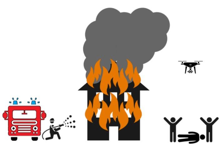
Library & Research Service | L&RS Spotlight                                                                      8

1. Principles of Drone Operation
The following chapter provides an overview of the various aspects of drone operation. This will
help the reader appreciate the strengths and weaknesses of existing drone technology.

1.1 Drone Types

     Drones can resemble small helicopters with multiple rotors, miniature aeroplanes, or
     balloons. Drones today can be as small as smartphones or as big as manned aircraft. Most
     drones are electric vehicles that are powered by on-board batteries.

Drones on the consumer and commercial markets come in a variety of designs, each with their
own technical strengths and weaknesses (see Table 1 below). As most drones are electric
vehicles, they rely on a limited battery supply to power their electronics and motors, which means
that the design of the drone will directly affect the length of time a drone can fly. This also impacts
on the types of jobs for which drones can be used.
Table 1: Drone Types

    Drone Type       Description                   Advantages                        Disadvantages

                     Drones that fly using         Most manoeuvrable drone type      Consume a lot of battery
                     several rotors (propellers)   as capable of Vertical Take-Off   power compared to
    Multi-rotor      which push air                and Landing (VTOL),7 can          other drone types, and
                     downwards and lift the        hover in place, and can           so cannot stay in the air
                     drone up.                     operate in narrow areas.          for very long.

                                                   Require less battery power to
                     Drones that resemble                                            Cannot VTOL or hover,
                                                   fly compared to multi-rotor
    Fixed-wing       aeroplanes, with two                                            require a lot of open
                                                   drones and can fly for longer
                     wings.                                                          space to fly.
                                                   periods.

                     Drones that resemble
                                                   Most energy-efficient drone       Worst manoeuvrability
                     large balloons or blimps.
                                                   type. May be able to operate      of the three types.
    Balloon          May either have rotors or
                                                   for days or even weeks in the     Vulnerable to wind when
                     rely on wind to move
                                                   sky.                              in the air.
                     around.

Hybrid drone designs are also possible. For example, a fixed-wing drone can have multiple rotors
that push air downward and enable VTOL functionality, exactly like a multi-rotor drone. These
rotors would only be used during take-off and landing. When the drone is in the air, it would fly like
a fixed-wing drone to benefit from reduced battery power use.

7   VTOL is when a drone can move directly up or down during take-off and landing. The drone therefore does
    not require an open area for take-off. An analogy can be drawn to aeroplanes and helicopters. Aeroplanes
    require very large runways for take-off and landing, whereas helicopters can take-off and land in relatively
    small areas.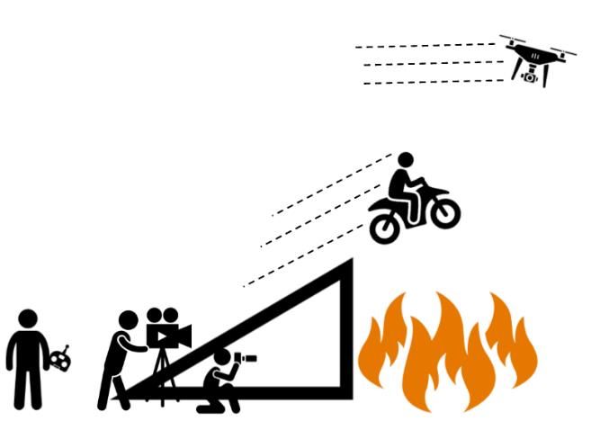
Library & Research Service | Consumer and Commercial Drones                                                         9

Consumer and commercial drones also come in an extensive range of sizes and weights. For
instance, certain consumer drones designed for portability may be the size of a smartphone,8
whereas commercial drones designed for heavy-duty operation can have sizes comparable to
manned aircraft. Facebook’s cancelled internet delivery drone, for example, had the wingspan of a
commercial jet.9
While their shapes and sizes may significantly differ, all drones have the same key technologies in
common. These are discussed in the following sections.

1.2 Drone-Pilot Communication Link

     Pilots control drones using remote-controllers. These remote-controllers communicate with
     drones using radio signals similar to WiFi. The radio signals are affected by the distance
     between the controller and the drone, obstacles between the two, and other nearby
     devices which can cause interference. As a result, there is a limit to how far away the pilot
     can safely fly the drone.

To safely operate, a drone and its pilot need to maintain a reliable channel of communication. This
section describes how this communication is achieved, and what its limitations are.
As an unmanned vehicle, the drone does not carry its pilot on-board. Instead, the pilot remains on
the ground and sends flight commands to the drone using a remote-controller. These flight
commands typically take the form of instructions to change the drone speed, travel direction or
height above ground. The drone, in turn, sends telemetry information10 about its flight back to the
pilot. For most types of drones, it is not feasible to use a cable to connect the drone back to its
pilot.11 Instead, the drone and the pilot’s remote controller communicate wirelessly, using radio
communication technology similar to WiFi.12 The radio signal for communication means that the
connection link can degrade in quality and even fail. The three factors that cause signal
degradation are discussed below.

8   For example, the Mavic Mini drone from manufacturer DJI which weighs only 249 grams (Last accessed 6
    January 2021).
9   Adam Satariano, ’Facebook Halts Aquila, Its Internet Drone Project’, New York Times, 27 June 2018 (Last
    accessed 6 January 2021).
10   Telemetry information refers to important information about the flight status of a drone, such as its height
    above ground, its speed, its GPS coordinates, and its battery power levels.
11   For an example of a drone that uses a wired cable refer to the AT&T COW drone (last accessed 6 January
    2021).
12   Cheaper drone models tend to use WiFi for the connection; whereas more expensive models adopt
    proprietary radio technology.
Library & Research Service | L&RS Spotlight 10
1.2.A Signal Degradation over Distance
All radio signals lose power as they travel away from their transmitter.13 When a signal arrives at a
radio receiver, the device attempts to decode the information carried by the signal. If the signal is
weak, then there is a chance that the data will be decoded
with errors. Modern radio equipment is designed to correct
these errors. However, the required process of error
correction introduces a lag to the signal.
High-end commercial drones on the market today are
marketed by manufacturers as capable of flying 5-10
kilometres away from their pilot before signal degradation
becomes severe enough to disrupt communications
between the two.14 These numbers tend to be based on
tests carried out in ideal conditions and do not account for
other causes of signal degradation (as discussed below).
1.2.B Signal Shadowing
When a solid object is placed in front of a light source, it creates a shadow behind it due to the
inability of the light to pass directly through the object. Radio signals experience a similar
shadowing effect when a solid object is placed between a radio transmitter and a radio receiver.15
Radio engineers commonly approximate the behaviour of radio signals to that of visible light when
considering the shadowing effect. A signal between a transmitter and a receiver is said to be Line-
of-Sight (LOS) if there are no obstacles between the two
devices so that the two can “see” each other. Otherwise,
this is considered Non-Line-of-Sight (NLOS).
A drone, therefore, benefits from a strong LOS signal to its
pilot (when the pilot’s remote-controller can see the
drone). If the pilot flies the drone behind an obstacle, in
what is referred to as Beyond Visual Line-of-Sight
(BVLOS) flight, then the signal will very quickly degrade. A
drone capable of flying kilometres away from the pilot
under LOS conditions may suddenly lose connection at a
distance of only a couple of hundred metres if it enters
BVLOS flight.
13 A. Goldsmith, Wireless Communications. Cambridge: Cambridge University Press, 2005, p.32.
14For example, the Autel Evo drone is marketed as being capable of communicating up to 9 kilometres away
from its pilot (last accessed 6 January 2021).
15 A. Goldsmith, Wireless Communications. Cambridge: Cambridge University Press, 2005, p. 48.Library & Research Service | Consumer and Commercial Drones 11
1.2.C Signal Interference
Every radio signal is transmitted on a specific radio
frequency. The spectrum of available radio frequencies is
limited. For this reason, in each country, the spectrum is
regulated by a communications regulator.16 The
communications regulator issues exclusive licences to
stakeholders such as mobile phone operators to use
specific spectrum bands. Certain spectrum bands, such as
the Industrial, Scientific and Medical (ISM) bands, are
intentionally kept licence-free to allow for free use by the
public. This lack of a licence requirement is why the ISM
bands are currently used by devices such as microwave
ovens, WiFi routers, and the current generation of
consumer drones.
When several devices transmit a signal on the same frequency, all the signals may be received
simultaneously by a radio receiver. This causes the signals to interfere with one another and make
it difficult for a receiver to decode the desired signal.17 What this means is that a drone which is
using the ISM bands for communicating with a pilot is vulnerable to any other nearby
communications occurring on the same frequencies (e.g. from devices such as WiFi routers).
Newer drone models are designed to account for this and can automatically choose specific ISM
frequencies which do not appear to be in use. However, this helps only when there are unused
ISM frequencies still available. For this reason, a drone which is capable of flying kilometres away
from its pilot in an unpopulated rural environment may simply not be capable of maintaining a radio
connection over the same distance when in a populated urban area.
1.3 Drone Artificial Intelligence
Drones have on-board sensors for tracking the surrounding environment. Drone Artificial
Intelligence (AI) uses these sensors to assist the pilot with safely flying the drone. This
assistance includes obstacle avoidance and safety features which are triggered in the
event that the radio signal with the pilot is lost. Some drone models can fly entirely by
themselves using just their AI, with no pilot control.
Drones are capable of a degree of independent navigation and flying. Using a variety of on-board
sensors, drones can make decisions independently of their pilot input. This section provides an
overview of how drones use AI to make decisions.
16In Ireland, the communications regulator is the Commission for Communication Regulation (ComReg)
(Last accessed 6 January 2021).
17 A. Goldsmith, Wireless Communications. Cambridge: Cambridge University Press, 2005, p. 507.Library & Research Service | L&RS Spotlight 12
The modern generation of commercially available drones come equipped with a variety of sensors
which allow them to be aware of their surrounding environment during flight, and relay that
information to the pilot (see Table 2 below).
Table 2: Drone Sensor Types
Sensors Measurement Purpose Description
Global
GPS receivers pick up signals from dedicated GPS
Positioning Drone location in three-
satellites, which are used to determine the exact
System (GPS) dimensional space
coordinates of a drone.
receivers
Cameras which are positioned around the drone that can
Infrared and
Distance to nearby detect nearby objects and calculate how far away they are
optical proximity
obstacles from a drone, similar to the parking sensors in certain
sensors
models of cars.
Inertial
Drone tilt, rotation and Sensors that tell the drone if it is tilted, rotating, or moving in
Measurement
acceleration a certain direction, similar to an electronic spirit level.
Unit (IMU)
Drone orientation relative
Compass Sensors that detect the earth's magnetic field.
to magnetic north
Sensors that measure air pressure, which changes as a
Barometer Drone height changes
drone moves up or down.
Sensors that monitor the temperature of drone components
Temperature of drone
Thermometer such as the electronics, motors, and batteries, to warn the
components
pilot if overheating occurs.
The exact combinations and configurations of sensors vary among drone models. Cheaper drones
which are designed as toys for children may not have any sensors, whereas industrial drones
intended for high-precision work may have all of the sensors listed, including backup sensors to
minimise the chance of errors. A drone that uses multiple down-facing proximity sensors to detect
the ground is shown in Figure 1 overleaf.
1.3.A Pilot Assistance
The drone AI uses the information from its sensors to keep the pilot informed about the state of the
flight, as well as performing certain flight operations independently of pilot input. For example, if a
drone detects an obstacle directly in its path, it will warn the pilot and may also choose to stop or
fly around the obstacle, even if the pilot does not issue a ‘stop command’. Newer drone models
can override a pilot’s flight instructions if the sensors suggest that the instruction is unsafe. Another
important example of this capability is the use of geofencing. Geofencing refers to areas which a
drone is not permitted to enter by its AI. Typically, these areas would be built into the drone by its
manufacturer and would be based on the locations of no-fly zones (as determined by aviationLibrary & Research Service | Consumer and Commercial Drones 13 organisations such as national aviation authorities).18 If the AI detects from its GPS information that it is inside a no-fly zone, it will issue a warning to the pilot and either stop or attempt to land. The AI on certain drone models also assists the pilot with flight. For example, a drone can automatically compensate for wind gusts, so that the drone is not blown off-course or flipped-over. The AI detects these wind gusts via its sensors, compensates against the wind to keep the drone steady and level, and warns the pilot about the presence of wind. This allows the pilot to focus on other aspects of the flight, instead of compensating for the wind. This acts as both a safety feature which protects the drone, as well as a navigational aid for the pilot. Figure 1. Ground proximity sensors on the underside of a drone 1.3.B Automatic & Autonomous Flight In addition to offering pilot assistance during flight, certain models of drones can fly by themselves using AI. This is referred to as automatic flight, whereby the human pilot oversees the flight and can assume manual control at any moment. Autonomous flight is also possible; this is when a drone is being piloted by AI with no direct communication to the pilot, such that the pilot is not able to take manual control of the drone. 18DJI, ‘DJI Improves Geofencing To Enhance Protection of European Airports and Facilities’, Press Release, 12 February 2019 (Last Accessed 6 January 2021).
Library & Research Service | L&RS Spotlight                                                                   14

The main types of AI-driven drone flights are given in Table 3 below.

Table 3: Types of AI-driven Drone Flights

 Type                     Description

                          An important safety feature that has become widespread among newer drone
                          models. If a drone loses the radio connection to its pilot (due to factors such as
 Return-to-Home (RTH)     signal shadowing) it will attempt to autonomously return back to where it began its
 flight                   flight (based on GPS information), while searching for the pilot’s radio signal and
                          attempting to reconnect. This failsafe ensures that a loss of radio signal while a
                          drone is mid-air will not result in a crash.

                          Using the drone software, the pilot draws a flight path that the drone should fly
 Following a designated   along, specifying its speed, height, and other flight behaviours. The drone then
 flight path              follows this flight path automatically, reacting to any obstacles but otherwise
                          keeping to the instructions specified by the pilot.

                          The pilot can choose to designate a certain area that they wish the drone to fly in,
                          and the drone AI will automatically calculate its own flight path within the bounds of
 Flying over a
                          this area. This type of automatic flight is typically used for surveying or photography
 designated area
                          work where a drone needs to fly over every part of a certain area to take recordings
                          or measurements.

                          Certain drone models have AI which is capable of image recognition. Using this, a
                          drone can be instructed to identify a moving object which it locates/identifies with its
 Object tracking          camera (i.e. ‘sees’). The drone then follows the object, keeping it in-frame. This type
                          of flight is popular for video-recording, as it allows the pilot to easily record a moving
                          object using the drone.

In the flight examples in Table 3, the drone communicates with the pilot whenever the radio
connection is available. The pilot can choose to override or cancel the AI at any time. As the AI is
flying the drone by itself, the pilot can also choose to allow the drone to disconnect from the pilot’s
remote-controller without triggering the RTH functionality, and thus fly autonomously. This allows
the drone to fly a large distance away from the pilot in BVLOS flight. However, the clear challenge
with this is that the pilot may not receive information from the drone about the flight, and therefore
cannot intervene if there is an emergency. At the time of writing, autonomous flight is illegal in
Ireland due to the safety concerns of allowing drones to fly with no pilot oversight.19

19The current regulations governing drone use in Ireland are the Commission Implementing Regulation (EU)
 2019/947 (Last accessed 6 January 2021), see Section 4.3.
Library & Research Service | Consumer and Commercial Drones 15
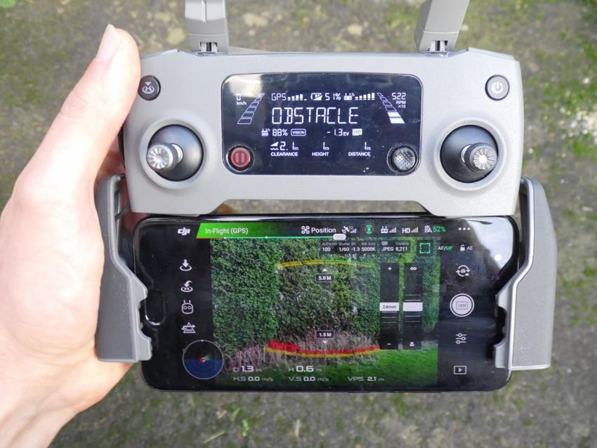
1.4 Drone Cameras
Most drone models have on-board cameras which send a live video feed back to the pilot.
This camera feed helps the pilot fly the drone and allows the pilot to take photos and
videos from the sky.
In addition to the optical sensors described in the previous section, most drone models are
equipped with a camera, which enables many of the current drone applications.20 The potential for
drones to be used to spy on people and violate their privacy is one of the bigger concerns with the
spread of drone technology; this concern has been raised in Dáil Éireann on several occasions.21
This section considers the camera capabilities of the typical consumer drone model.
Figure 2. Drone remote-controller displaying drone camera view and flight information
Typical commercial drone cameras attempt to strike a balance between being pilot-friendly and
offering good surveillance opportunities. While the drone camera may also be used by the drone AI
for flight purposes, the main function of the camera is to provide the pilot with a live view from the
drone.
20 See Chapter 3.
21Minister for Transport, Tourism and Sport, Shane Ross T.D., Response to Parliamentary Question No. 557
(Aviation Industry Regulations), Dáil Éireann Debate, 16 May 2017 (Last accessed 6 January 2021);
Minister for Justice and Equality, Charles Flanagan T.D., Response to Parliamentary Question No. 355
(Legislative Measures), Dáil Éireann Debate, 5 November 2019 (Last accessed 6 January 2021).Library & Research Service | L&RS Spotlight 16
This has two important functions:
• The drone camera assists the pilot with flying the drone, by letting the pilot see nearby
obstacles and other important landmarks.
• The drone camera gives the pilot an aerial view of the surroundings, letting them take
photos and videos from the sky and engage in aerial surveillance.
These two functions impose very different requirements on the design of the drone camera: the
former requires the camera to be able to see obstacles around it, while the latter requires a camera
which can see things clearly from a distance. To give the pilot a clear picture of the drone
surroundings for flight, the camera needs to have good peripheral vision (which is referred to as a
“wide field-of-view”). Such a camera would allow the pilot to see everything in front of the drone in
a wide area. The fundamental trade-off with a wide field-of-view camera is that it sacrifices a
detailed view of distant objects to achieve this peripheral vision. This means that such a camera
does not provide the pilot with good surveillance images.
When a pilot takes a photo or records a video, a copy of the material is stored on the pilot’s mobile
device (such as a smartphone).22 Certain models of drones can also store the material via internal
memory, allowing them to record photos and videos, even when a connection to the pilot is
unavailable (such as during autonomous flight).
1.5 Anti-Drone Measures
Authorities have access to a variety of tools and technologies to stop trespassing drones.
These include special sensors which detect and track drones, devices which can hack a
drone and force it to land, as well as devices which can knock a drone out of the sky or
otherwise destroy it.
Drones flying into sensitive areas without permission are becoming a growing problem. In
response, a variety of technological solutions have been created to give authorities (such as law
enforcement authorities) the ability to track, deter, capture, or destroy trespassing drones, while
also tracking down their pilots.23
Anti-drone measures can be grouped under three categories:
• detecting drones,
• disrupting drone communications, and
• physically disabling the drone in flight.
22By connecting drones to smartphones members of the public can quickly and easily share their drone
footage over the internet.
J. Wang, Y. Liu, and H. Song, ‘Counter-Unmanned Aircraft System(s) (C-UAS): State of the Art,
23
Challenges and Future Trends’ Arxiv e-prints, August 2020.Library & Research Service | Consumer and Commercial Drones 17 1.5.A Detecting Drones The first steps to stopping a drone involve detecting its presence and determining its location. Drones can vary in size and their rotors can be quite loud (particularly for multi-rotor drones that have several rotors). Therefore, detecting a drone can be as straightforward as simply seeing it and hearing it. While straightforward, this type of visual detection can be susceptible to errors. In December 2018, Gatwick airport had to shut down its flights for almost two days due to sightings of trespassing drones on airport grounds. Numerous drone sightings were reported by members of the public. However, in the aftermath of the intrusion, the accuracy of these reports was questioned.24 More accurate drone detection can be achieved using the following technical means: Radar. Manned aircraft such as aeroplanes and helicopters are tracked by authorities using radar waves, which are a type of radio signal. A transmitter sends out radio signals into the sky and these signals are reflected off the aircraft back down to earth. A radar dish picks up these signals and determines the location of the aircraft in the sky based on how the signal was reflected. Radar detection can accurately detect aircraft across extremely large distances in this manner. However, radar designed to detect manned aircraft has difficulty detecting drones (due to their size).25 For this reason, new types of radar designed to detect small drones are required. These anti-drone radar systems are designed to detect and identify the unique features of drones, such as their spinning rotors. The disadvantage of these systems, though, is that they work over much shorter distances than radar for manned aircraft. Detecting the drone-pilot wireless link. As discussed in Section 1.2, drones use radio signals to wirelessly communicate with their pilot. This radio communication can be detected by anti-drone equipment and used to locate and track the drone.26 The effectiveness of this method depends on two factors. First, if the drone is flying autonomously, it may not be communicating with a pilot at all. Therefore, there may not be any radio signal to detect. Second, if the drone radio signal is using the WiFi frequency band, then it may be difficult for the anti-drone equipment to distinguish the drone signal from other types of WiFi signals. As a result, the anti-drone equipment may not identify the drone, or it may detect another WiFi signal and mistake it for a drone. Drone visual detection. Drones can have very distinct colours and shapes compared to other flying objects such as birds. For this reason, they can be detected using cameras that have image- recognition AI.27 These types of cameras may not be suitable during night or in other low-light conditions. However, thermal cameras can be used instead as drones generate heat from their 24‘Some Gatwick drone sightings 'may have been police devices'’, RTÉ News, 29 December 2018 (Last accessed 6 January 2021); Samira Shackle, ‘The mystery of the Gatwick drone’, The Guardian, 1 December 2020 (Last accessed 6 January 2021). I. Guvenc, F. Koohifar, S. Singh, M. L. Sichitiu, and D. Matolak, ‘Detection, Tracking, and Interdiction for 25 Amateur Drones’ IEEE Communications Magazine, vol. 56(4), April 2018, pp. 75-81. 26 Ibid. 27C. Briese, A. Seel, and F. Andert, ‘Vision-based detection of non-cooperative UAVs using frame differencing and temporal filter’ International Conference on Unmanned Aircraft Systems (ICUAS), June 2018, pp. 606-613.
Library & Research Service | L&RS Spotlight                                                                      18

batteries, electrical circuits, and motors during operation. This makes them visible to thermal
cameras irrespective of the time of day.
Drone sound detection. As drone rotors create noise, they
can be detected using microphones specially designed for
the purpose. Researchers have designed microphones that
have AI which allows them to identify the specific sound of
drone rotors.28 By placing several microphones in a location
and connecting those microphones together, a microphone
                     system can not only detect a drone but
                     also determine its location, by
                     comparing the sound levels at the
                     different microphones.29 The
                     disadvantage of this detection approach
                     is that it works over a relatively short
distance and is vulnerable to ambient noise from the environment.
Each of the detection methods described above has its own strengths and weaknesses. A reliable
drone detection system would therefore need to combine several detection methods to ensure its
accuracy.

1.5.B Disrupting Drone Communications
Once a trespassing drone is identified and located, lawful
authorities can use a variety of methods to stop the
drone.30 One approach is to disrupt the drone’s
communication systems, which can involve the following:
Signal jamming. The drone-pilot radio link is vulnerable to
other radio transmissions on the same frequency. By
intentionally transmitting a high-power radio signal on the
frequency that the drone is using it is possible to stop
communication with the pilot. If a drone is not flying
autonomously, then jamming the communication signal will
result in a number of potential outcomes. Depending on the
drone model, these include either the drone triggering its
RTH failsafe and flying back to the pilot, the drone stopping

28S. Jeon, J. Shin, Y. Lee, W. Kim, Y. Kwon, and H. Yang, ‘Empirical study of drone sound detection in real-
 life environment with deep neural networks’ 25th European Signal Processing Conference (EUSIPCO),
 September 2017, pp. 1858-1862.
29X. Chang, C. Yang, J. Wu, X. Shi, and Z. Shi, ‘A Surveillance System for Drone Localization and Tracking
 Using Acoustic Arrays’ IEEE 10th Sensor Array and Multichannel Signal Processing Workshop (SAM), July
 2018, pp. 573-577.
30Note that in Ireland drones are legally treated as aircraft, and therefore it is unlawful for members of the
 public to interfere with their flight or attempt to destroy them.
Library & Research Service | Consumer and Commercial Drones 19 in mid-air, or falling out of the sky. As many drone models rely on GPS transmissions from satellites for their navigation, these signals can also be jammed. Note that losing the GPS signal by itself may not be sufficient to stop a drone flight, particularly if it is being flown manually by a pilot. While effective, the disadvantage of signal-jamming is that it can negatively impact bystanders. Transmitting jamming signals on WiFi frequencies will disrupt WiFi communication for all nearby devices, not just the drone. Similarly, a GPS jammer can disable GPS for everyone in its vicinity, which can be dangerous if used in an airport environment with aircraft in the air. Signal spoofing. Signal spoofing refers to the practice of sending false signals to a receiving device, to fool it into doing something the authorities want. For example, the authorities may transmit false GPS signals which are designed to fool the drone into leaving the area or landing.31 If the authorities know what kind of radio signal the pilot uses to talk to the drone, then they can spoof the pilot’s signal. This will fool the drone into treating the authorities as its pilot, and so it will obey their flight commands. While successfully spoofing a signal and fooling the drone is more technically complicated than simply jamming those signals, signal spoofing is far less likely to do harm to others in the area. 1.5.C Physically Disabling the Drone When disrupting the drone’s communications systems is ineffective or unsuitable, a variety of solutions exist to stop the drone more directly. These involve the following: Shooting the drone down. The most straightforward way to permanently disable a drone is to shoot it down. During the Gatwick airport incident of December 2018, British Armed Forces snipers were deployed around the airport area with the intention of firing on the drone.32 However, a moving drone may pose a very challenging target, even for a trained sharpshooter. Military-grade anti-missile systems such as the American Close-in Weapon System (CIWS)33 can offer far more reliable protection. The obvious drawback of this approach is that gunfire may simply be too dangerous due to the risk of stray bullets. Depending on the location and the risk posed by the drone, the option of shooting the drone down may create a bigger problem than it will solve. A.J. Kerns, D.P. Shepard, J.A. Bhatti, and T.E. Humphreys, ‘Unmanned Aircraft Capture and Control Via 31 GPS Spoofing’ Journal of Field Robotics, vol. 31(4), June 2014, pp. 617-636. 32‘Gatwick chaos: Police ‘could shoot down drone’’, BBC News, 21 December 2018 (Last accessed 6 January 2021). 33John Keller, ‘Raytheon to upgrade and overhaul computer-controlled radar-guided shipboard weapons in $109.6 million order’, Military & Aerospace Electronics, 12 March 2020 (Last accessed 6 January 2021).
Library & Research Service | L&RS Spotlight                                                             20

Directed-energy weapons. This category of weapon involves using focused energy in the form of
lasers34 or microwaves35 to damage the drone. A drone is vulnerable to laser beams due to its
reliance on its camera and other optical sensors; a laser beam can temporarily or permanently
blind these sensors. A sufficiently powerful laser beam can also cause the drone to heat up to the
point where its electronics and battery break, causing the drone to crash. A directed microwave
beam, meanwhile, can disable a drone’s electronics, thereby causing it to malfunction and likely
crash. The advantage of these directed-energy weapons is that they are less dangerous to
bystanders than the gunfire-based alternatives. These weapons still pose a risk of
causing unintended damage to nearby equipment, however. Laser beams can
cause damage over large distances; firing a laser into the sky can accidentally
strike distant aeroplanes or satellites in orbit.
Nets. As a drone requires rapidly spinning rotors to move, catching it in a net and
trapping the rotors is a reliable way to stop it. The difficulty of achieving this lies in
bringing the net to the drone’s location in the air. One solution is to fire the net at
the drone from a portable cannon using compressed air.36 In Japan, authorities
are using their own drones to carry these nets and “sweep up” the intruding
drones.37 While the difficulty of trapping the drone in a net is a disadvantage, the
big benefit of this anti-drone solution is that it is much safer for bystanders and
nearby equipment (as compared to the options discussed above).
Trained attack birds. A novel solution that has been explored38 (and subsequently abandoned39)
by Dutch authorities is the use of trained birds to attack and bring down drones. Certain birds of
prey such as falcons have a long history of being trained for hunting. This type of animal
husbandry can be adapted for dealing with drones. The effectiveness of this approach relies
entirely on how well the animal is trained, as it may have problems responding to commands from
its handlers or identifying the correct drone to attack, especially if there are other drones operating
lawfully in the area. Another drawback of this approach is the relative cost. Trained birds can be
prohibitively expensive; the Dutch authorities abandoned their anti-drone attack bird program due
to its lack of cost-effectiveness.40

34Ben Wolfgang, ‘Air Force tests new anti-drone laser weapon’, Washington Times, 15 September 2020
 (Last accessed 6 January 2021).
 Evan Ackerman, ‘Raytheon Sets Phasers to Drone Destruction with Directed Energy Weapon Test’, IEEE
35

 Spectrum Tech Talk, 28 November 2016 (Last accessed 6 January 2021).
 Matt Reynolds, ‘Anti-drone net launcher can down quadcopters from 100 metres’, Wired Magazine UK, 4
36

 March 2016 (Last accessed 6 January 2021).
 Keith Wagstaff, ‘Tokyo Police to Deploy Net-Carrying Drone to Catch Rogue Drones’, NBC News, 11
37

 December 2015 (Last accessed 6 January 2021).
38   ‘Dutch police fight drones with eagles’, BBC News, 12 September 2016 (Last accessed 6 January 2021).
39‘Dutch police drops drone-hunting eagles project’, NL Times, 7 December 2017 (Last accessed 6 January
 2021).
40   Ibid.
Library & Research Service | Consumer and Commercial Drones                                       21

1.5.D Assistance from Drone Manufacturers
Drone manufacturers can play a big part in preventing drone misuse. As previously mentioned in
Section 1.3, certain drone manufacturers include geofencing restrictions into a drone to prevent it
from flying into restricted areas. Drone manufacturers can provide authorities with tools to easily
detect and track their specific drones.41 With the cooperation of drone manufacturers, authorities
can respond to drone threats more quickly and with less risks to members of the public.

41   An example of this is the DJI Aeroscope, (Last accessed 6 January 2021).
You can also read