Country Report: Bangladesh - ADRC Visiting Researcher Programme FY2020 - Abdul Quader - Asian Disaster Reduction ...
←
→
Page content transcription
If your browser does not render page correctly, please read the page content below
ADRC Visiting Researcher Programme FY2020

                         Country Report:
                            Bangladesh

          By

          Abdul Quader
          Deputy Secretary
          Government of the People’s Republic of Bangladesh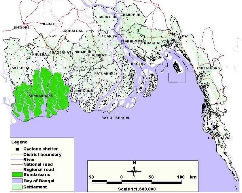
ADRC Visiting Researcher Programme, FY2020, Country Report: Bangladesh

                                Disclaimer

This report was compiled by an ADRC visiting researcher (VR) from ADRC
member countries. The views expressed in the report do not necessarily
reflect the views of the ADRC. The boundaries and names shown, and the
designations used on maps in the report also do not imply official
endorsement or acceptance by the ADRC.

                                       2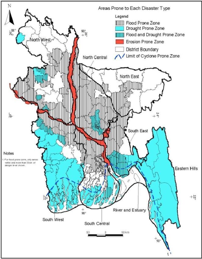
ADRC Visiting Researcher Programme, FY2020, Country Report: Bangladesh

Table of Contents
Chapter-1: General Information ............................................................................................................. 5
   1.1 General Description ...................................................................................................................... 5
   1.2. Geographical Information ............................................................................................................ 5
   1.3. Climate ......................................................................................................................................... 8
   1.4. Administrative Divisions............................................................................................................. 10
   1.5. Population .................................................................................................................................. 11
   1.6. Education ................................................................................................................................... 12
   1.7.Economy ..................................................................................................................................... 13
   1.8.Art and Culture............................................................................................................................ 14
Chapter-2: Disaster management overview ......................................................................................... 15
   2.1. Country risk profile .................................................................................................................... 15
      2.1.1 Earthquake Risk ................................................................................................................... 18
      2.1.2 Thunderstorm: A new disaster frontier in Bangladesh......................................................... 20
   2.2. Natural hazards likely to affect .................................................................................................. 21
      2.2.1 Flood .................................................................................................................................... 22
      2.2.2. Tropical cyclone .................................................................................................................. 23
      2.2.3.Tornado ................................................................................................................................ 25
      2.2.4.Riverbank erosion ................................................................................................................ 27
      2.2.5.Drought ................................................................................................................................ 28
      2.2.6. Earthquake .......................................................................................................................... 29
   2.3. Recent Major Disasters .............................................................................................................. 31
Chapter-3:Disaster Management System in Bangladesh ..................................................................... 35
   3.1. Disaster Risk ............................................................................................................................... 35
      3.1.1. Policy framework for Disaster Risk Reduction .................................................................... 35
      3.1.2 Risk informed sharing platform ........................................................................................... 36
      3.1.3.Risk inform to the community level ..................................................................................... 37
   3.2. Risk Governance to manage Disaster Risk ................................................................................. 38
   3.3Regulative Framework ................................................................................................................. 39
   3.4 National Disaster Context ............................................................................................................ 42
      3.4.1 GOB Vision on Disaster Management .................................................................................. 42
      3.4.2 Mission of the MODMR ....................................................................................................... 42
      3.4.3. Overall Objective ................................................................................................................. 42
      3.4.4 National Committees under SOD ......................................................................................... 43
   3.5 National Institutions for Disaster Management ......................................................................... 44
      3.5.1 Department of Disaster Management (DDM) ..................................................................... 44
      3.5.2 Cyclone Preparedness Program (CPP) ................................................................................. 45

                                                                            3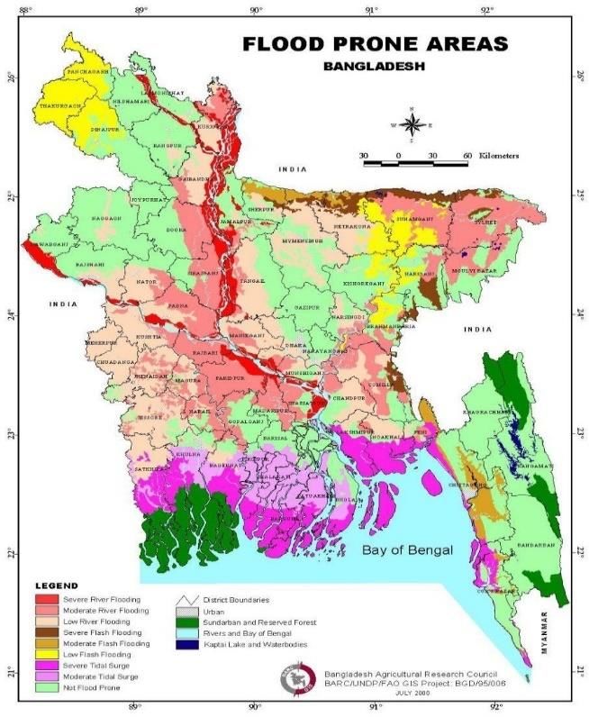
ADRC Visiting Researcher Programme, FY2020, Country Report: Bangladesh

       3.5.3. Space Research and Remote Sensing Organization (SPARRSO) ......................................... 45
       3.5.4.Bangladesh Meteorological Department (BMD) ................................................................. 46
   3.6. Other Institutions for Disaster Management............................................................................. 46
       3.6.1. Center for Environmental and Geographic Information Services (CEGIS) .......................... 46
       3.6.2 The Institute of Water and Flood Management (IWFM) ..................................................... 47
       3.6.3 Institute of Water Modelling (IWM) .................................................................................... 47
   3.8.ADRC Counterpart....................................................................................................................... 53
4. References ........................................................................................................................................ 53

                                                                           4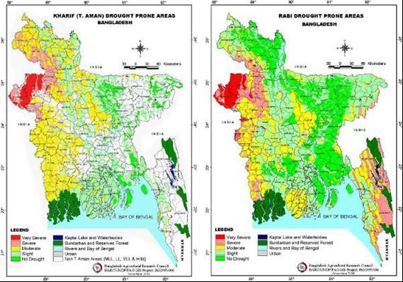
ADRC Visiting Researcher Programme, FY2020, Country Report: Bangladesh

                          Chapter-1: General Information

1.1 General Description

Bangladesh officially the People's Republic of Bangladesh, is a country in South Asia. It is
the eighth-most populous country in the world, with a population exceeding 164 million
people (Bangladesh Population, 2020). In terms of landmass, Bangladesh ranks 92nd,
spanning 148,460 square kilometres (57,320 sq mi), making it one of the most densely
populated countries in the world. Bangladesh shares land borders with India to the west, north,
and east, Myanmar to the southeast, and the Bay of Bengal to the south. It is narrowly
separated from Nepal and Bhutan by the Siliguri Corridor, and from China by Sikkim, in the
north, respectively. Dhaka, the capital and largest city, is the nation's economic, political and
cultural hub. Chittagong, the largest seaport, is the second-largest city (Wikipedia, 2021).
Bangladesh is one of the emerging and growth-leading economies of the world, and is also
one of the Next Eleven countries, with one of the fastest real GDP growth rates.
The Bangladeshi economy is the 39th-largest in the world by nominal GDP, and the 29th-
largest by Purchasing Power Parity (PPP) (Wikipedia, 2021).

1.2. Geographical Information

Bangladesh is a low-lying, riverine country with a
largely marshy jungle coastline of 710 km (441 mi)
on the northern littoral of the Bay of Bengal.Formed
by a delta plain at the confluence of the Ganges
(Padma), Brahmaputra(Jamuna) and Meghna River
sand their distributaries and tributaries, Bangladesh's
alluvial soil is highly fertile, but vulnerable to flood
and   drought.      The   geographical    position    of
Bangladesh showing in figure -1 and information
given in Table-1.

                                                                           Figure 1: Global Map

                                                 5
ADRC Visiting Researcher Programme, FY2020, Country Report: Bangladesh

Table 1: Geographical Information

                        Name                                              Description
Geographical Coordinates                                  20°34’ to 26°38’ north latitude and 88°01’to
                                                          92°42’ east longitude

Area                                                      Total: 147,570 km²
                                                          Country comparison to the world: 94
                                                          Land: 133,910 km²
                                                          Water: 10,090 km²

Land boundaries                                           Total: 4,246 km
                                                          Border countries: Myanmar 193 km, India
                                                          4,053 km
Maritime claims                                           Contiguous zone: 18 nmi (33.3 km; 20.7 mi)
                                                          Continental shelf: up to the outer limits of the
                                                          continental margin Exclusive economic zone:
                                                          200 nmi (370.4 km; 230.2 mi)
                                                          Territorial sea: 12 nmi (22.2 km; 13.8 mi)
Coastline                                                 580 km with 273 km unbroken longest sea
                                                          beach in the world
Elevation extremes                                        Lowest point: Indian Ocean 0 m
                                                          Highest point: In the Mowdok range at 1052
                                                          m (at N 21°47'12" E 92°36'36")

                                                      6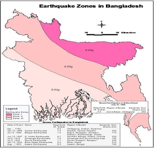
ADRC Visiting Researcher Programme, FY2020, Country Report: Bangladesh

Hills rise above the plain only in the Chittagong Hill
Tracts in the far southeast and the Sylhet division in
the northeast. The whole country consists of mainly
low and flat land, except for the hilly regions in the
northeast and southeast. A network of rivers, with their
tributaries and distributaries crisscross the country.
Physiographically, the country can be divided into hills,
uplifted land blocks, and the majority alluvial
plainswith very low       mean       elevation    above   sea
level .In terms of geographical location, Bangladesh
is in the context of the Ganges-Brahmaputra-
Meghna     (GBM     )      river     system.     Geologically,

Bangladesh is a part of the Bengal Basin, one of the
                                                                        Figure 2: Physiography of Bangladesh
largest geosynclinals     in   the     world.The     Basin
is bordered on the north by the steep Tertiary Himalayas; on the northeast and east by the late
Tertiary Shillong Plateau, the Tripura hills of lesser elevation, and the Naga-Lusai folded
belt; and in the west by the moderately high, ancient Chotanagpur plateau. The southern
fringe of the basin is not distinct but geophysical evidence indicates it is open
towards the Bay of Bengal for a considerable distance. The formation and growth of the
Bengal Basin is directly related to the origin and morphology of the Indo-Gangetic
trough, which itself is overlaid and filled by sediments thousands of meters                   thick. The
broad geological features of the Bengal Basin and its prominent tectonic elements are
Indian platform, Bengal foredeep, ArakanYoma folded system, and the Sub-Himalayan
Foredeep. Other features are Rangpur Saddle, Dinajpur slope, Bogra slope, Hinge Zone,
Barisal High, and Troughs of Sylhet, Faridpur and Hatiya, etc.

                                                     7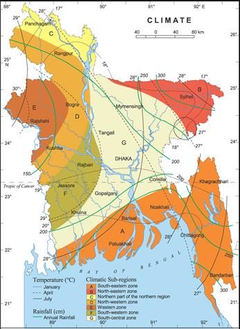
ADRC Visiting Researcher Programme, FY2020, Country Report: Bangladesh

1.3. Climate

Bangladesh has a subtropical monsoon climate marked by broad seasonal fluctuations in
rainfall, mild temperatures and high humidity. Regional climatic variations are small in this
flat region. Three seasons are commonly known: the mild, humid summer from March to
June; the cold, rainy monsoon season from June to October; and the cool, dry winter from
October to March. In general, the mean summer temperatures are between 32°C and 38°C. In
most parts of the world, April is the warmest month. January is the coldest month in which
the average temperature for much of the world is 10°C.

The winds are mainly from the north and northwest in the winter, moving softly at one to
three kilometres per hour in the northern and central regions and three to six kilometres per
hour along the coast. From March to May, intense thunderstorms, named to the northwest by
local English speakers, emit winds of up to 60 kilometres per hour. During the extreme
storms of the early summer and late monsoon season, southerly winds of more than 160
kilometres per hour trigger waves to crest as large as 6 metres in the Bay of Bengal, creating
catastrophic floods in coastal areas.

Heavy rainfall is traditional of Bangladesh. With the exception of the comparatively dry
western area of Rajshahi, where annual rainfall is approximately 160 cm, most areas of the
world receive at least 200 cm of rainfall each year. Due to its position just south of the
foothills of the Himalayas, where monsoon winds transform west and northwest, the district
of Sylhet in northeast Bangladesh has the highest annual rainfall.

About 80 percent of Bangladesh's rainfall comes during the monsoon season. Monsoons are
the product of contrasts between low and high air pressure areas arising from unequal heating
of soil and water. During the hot months of April and May, hot air rises across the Indian
subcontinent, producing low-pressure areas in which colder, and moist-bearing winds from
the Indian Ocean surge. This is the southwestern monsoon, which starts in June and typically
continues until September. Divided towards the Indian landmass, the monsoon flows into two
branches, one of which hits western India. The other passes up the Bay of Bengal and through
eastern India and Bangladesh, crossing the plains to the north and northeast, until turning to
the west and northwest towards the foothills of the Himalayas.

Natural calamities, such as hurricanes, tropical cyclones, tornadoes, and tidal bores—
destructive waves or floods triggered by floods rushing up estuaries—stricken the region,

                                                 8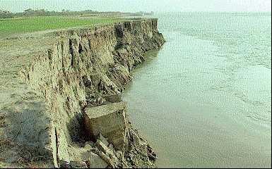
ADRC Visiting Researcher Programme, FY2020, Country Report: Bangladesh

especially the coastal belt, almost every
year. Between 1947 and 1988, thirteen
cyclones     struck    Bangladesh,     causing
tremendous loss of life and property. In
May 1985, for example, a strong cyclone
storm, packed with 154 kilometres per hour
of wind and waves 4 metres high, swept
southeast and south Bangladesh, killed
more than 11,000 citizens, destroyed more
than 94,000 homes, killed some 135,000
head of livestock, and damaged nearly 400
kilometres        of         critically-needed
embankments (Wikipedia, 2021).

Annual monsoon rains result in loss of
                                                 Figure 3: Climate of Bangladesh
human life, disruption to property and
communication networks and a lack of drinking water contributing to the spread of disease.
For example, two-thirds of Bangladesh's sixty-four districts sustained severe flood damage in
1988 as a consequence of the exceptionally heavy rains that overwhelmed the river systems.
Millions were left homeless and lacking clean water. About 2 million tonnes of crops have
been confirmed lost and rescue work has been rendered much more complicated than normal
because the flood has made transport of some sort incredibly difficult. There are no
safeguards against cyclones and tidal bores except for issuing early notice and having secure
public buildings where citizens can take refuge (Khatun, Rashid, & Hygen, 2016).

                                                  9
ADRC Visiting Researcher Programme, FY2020, Country Report: Bangladesh

1.4. Administrative Divisions

Bangladesh is divided into eight administrative divisions,each named after their respective
divisionalHeadquarters:Barisal (officially Barishal), Chittagong (officially Chattogram), Dha
ka, Khulna,,Mymensing,Rajshahi, Rangpur, and Sylhet.
Divisions are subdivided into districts (zila). There are 64
districts   in   Bangladesh,   each    further        subdivided
into upazila (subdistricts) or thana. The area within each
police station, except for those in metropolitan areas, is
divided into several unions, with each union consisting of
multiple villages. In the metropolitan areas, police stations
are divided into wards, which are further divided
into mahallas.There are no elected officials at the
divisional or district levels, and the administration is
composed only of government officials. Direct elections
are held in each union (or ward) for a chairperson and a
number of members. In 1997, a parliamentary act was passed to          Figure 4: Administrative Divisions
reserve three seats (out of 12) in every union for female candidates (Wikipedia, 2021). There
are 08 large city corporations in Bangladesh. Dhaka is the capital and largest city of
Bangladesh.

                                                 10
ADRC Visiting Researcher Programme, FY2020, Country Report: Bangladesh
1.5. Population
Estimates of the Bangladeshi population vary, but UN data suggests 161,376,708 (162.9
million) in 2017. Bangladesh is the world's eighth-most-populous nation and the most
densely-populated large country in the world, ranking 7th in population density even when
small countries and city-states are included. The country's population-growth rate was among
the highest in the world in the 1960s and 1970s, when its population grew from 65 to
110 million. With the promotion of birth control in the 1980s, Bangladesh's growth rate
began to slow. Its total fertility rate is now 2.05,lower than India's (2.58) and Pakistan's (3.07).
The population is relatively young, with 34 percent aged 15 or younger and five percent 65 or
older. Life expectancy at birth was estimated at 72.49 years in 2016. Bengalis are 98 percent
of the population.Of Bengalis, Muslims are the majority, followed
by Hindus, Christians and Buddhists. The ethnic minority population includes
the Chakma, Marma, , Tripuri, Kuki, Khiang,
Khumi, Murang, Mru, Chak, Lushei, Bawm, BishnupriyaManipuri, Khasi, Jaintia, Garo, Sant
al, Munda and Oraon tribes. The forcefully displaced Mayanmar citizen at around 1 million,
making Bangladesh one of the countries with the largest refugee populations in the world
(https://en.wikipedia.org/wiki/Bangladesh, 2021).
11ADRC Visiting Researcher Programme, FY2020, Country Report: Bangladesh
1.6. Education
Bangladesh has a literacy rate of 72.9 percent as of 2018: 75.7% for males and 70.09% for
females. The country's educational system is three-tiered and heavily subsidised, with the
government operating many schools at the primary, secondary and higher secondary levels
and subsidizing many private schools. In the tertiary education sector, the Bangladeshi
government funds over 45 state universities through the University Grants Commission.The
education system is divided into five levels: primary (first to fifth grade), junior secondary
(sixth to eighth grade), secondary (ninth and tenth grade), higher secondary (11th and 12th
grade), and tertiary.Five years of secondary education (including junior secondary) ends with
a Secondary School Certificate (SSC) examination. Since 2009, the Primary Education
Closing (PEC) examination has also been introduced. Students who pass the PEC
examination proceed to secondary or matriculation training, culminating in the SSC
examination.Students who pass the PEC examination proceed to three years of junior
secondary education, culminating in the Junior School Certificate (JSC) examination.
Students who pass this examination proceed to two years of higher secondary education,
culminating in the Higher Secondary School Certificate (HSC) examination. Education is
primarily in Bengali, but English is commonly taught and used. Many Muslim families send
their children to part-time courses or full-time religious education in Bengali and Arabic in
madrasas. Article 17 of the Bangladesh Constitution (The Constitution of the People's
Republic of Bangladesh) provides that all children between the ages of six and ten years
receive a basic education free of charge (Bangladesh, 2021).Universities in Bangladesh are of
three general types: public (government-owned and subsidised), private (privately owned
universities) and international (operated and funded by international organisations). They are
accredited by and affiliated with the University Grants Commission (UGC), created by
Presidential Order 10 in 1973.The country has 47 public,105 private and two
international universities . (Wikipedia, 2021).
12ADRC Visiting Researcher Programme, FY2020, Country Report: Bangladesh
1.7.Economy
Bangladesh has the world's 39th largest economy in terms of market exchange rates and 29th
largest in terms of purchasing power parity, which ranks second in South Asia after
India. Bangladesh is also one of the world's fastest-growing economies and one of the fastest
growing middle-income countries. The country has a market-based mixed economy.
A developing nation, Bangladesh is one of the Next Eleven emerging markets. Economic
growth slowed to 5.24 percent in FY2019-20, according to the provisional estimates of BBS,
which is the lowest since FY2008-09. As per final estimate GDP growth was 8.15 percent in
FY2018-19. According to the provisional estimate of BBS, the growth of agriculture sector
has slowed to 3.11 percent in FY2019-20, from 3.92 percent in FY2018-19. During the same
period, industry sector grew by 6.48 percent, which was 12.67 percent in the previous fiscal
year. The service sector grew by 5.32 percent in FY2019-20 compared to 6.78 percent in the
previous fiscal year. The contribution of agricultural, industry and service sectors reached at
13.35 percent, 35.36 percent and 51.30 present respectively in FY2019-20 against 13.65
percent, 35.00 percent and 51.35 percent respectively in the previous fiscal year.
The economy is driven by strong domestic demand. The private sector of Bangladesh has
rapidly expanded, with a number of conglomerate driving the economy. Major industries
include textiles, pharmaceuticals, shipbuilding, steel, electronics, energy, construction
materials, chemicals, ceramics, food processing, and leather goods. Export-oriented
industrialization has increased with fiscal year 2018–19 exports increasing by 10.1% over the
previous year to $40 billion. Most export earnings are from the garment-manufacturing
industry. Bangabandhu Bridge, commonly called the Jamuna Multi-purpose Bridge, was the
11th longest bridge in the world and the 6th longest bridge in South Asia when constructed in
1998.Agriculture is the largest sector of the economy, making up 14.2 percent of
Bangladesh's GDP in 2017 and employing about 42.7 percent of the work force.The
agricultural sector impacts employment generation, poverty alleviation, human
resources development and food security. More Bangladeshis earn their living from
agriculture than from any other sector. The country is among the top producers
of rice (fourth), potatoes (seventh), tropical fruits (sixth), jute (second), and farmed fish
(fifth).Bangladesh is the seventh-largest natural gas producer in Asia, ahead of neighbouring
Myanmar, and 56 percent of the country's electricity is generated by natural gas.The country
13ADRC Visiting Researcher Programme, FY2020, Country Report: Bangladesh
has three UNESCO World Heritage Sites (the Mosque City, the Buddhist Vihara and
the Sundarbans) and five tentative-list sites (MoF, 2020).
1.8.Art and Culture
Bangladesh is a melting pot of races. She, therefore, has a mixed culture. Her deep rooted
heritage is amply reflected in her architecture, literature, dance, drama, music and painting.
Bangladeshi culture is influenced by three great religions- Hinduism, Buddhism and
Islam in successive order, with Islam having the most pervading and lasting impact. Like a
colorful montage, the cultural tradition of the country is a happy blending of many variants,
unique in diversity but in essence greatly symmetrical.
Figure 5: Ahsan Monzil
Figure 6: Bengali Traditional Handcraft Nokhsi Katha
14ADRC Visiting Researcher Programme, FY2020, Country Report: Bangladesh
Chapter-2: Disaster management overview
2.1. Country risk profile
Bangladesh is considered as a developing economy. Bangladesh has achieved rapid and
spectacular improvements in many social development indicators during the last two decades
or so. Within South Asia, Bangladesh has improved its position in the region as a whole in a
number of human development indicators. (Asadullah, Mahmud, & Savoia, 2012).This has
all been achieved against the backdrop of being exposed to over population, natural and
human-induced hazards. It is estimated that 14% of Bangladesh’s GDP is exposed to disasters
on an annual basis. This is a testament to the innate resilience of the Bangladeshi people who
continue to make developmental progress while living with disasters and climate risk (MoEF,
2013). Every year the country faces many natural disasters like floods, cyclone, tidal surges,
tornado, thunderstorm, river and costal erosion, landslides, salinity intrusion, hailstorm,
extreme weather events etc (Agrawala, 2003). With the country’s geographical location, its
topography and high population density, the frequent occurrence of natural hazard events
often offsets in high loss of life and economic damage. Simultaneously, the country is at risk
from adverse impacts of climate change and variability. It is therefore likely that both acute
hazards (such as flooding or cyclonic events) and chronic hazards (drought, sea level rise and
saline intrusion, for example) will be more damaging to human lives and properties in the
contexts of flourishing economic conditions where more investments will create more
economic activities, e.g. infrastructure and human engagements in areas susceptible to
different hazards. The disasters that Bangladesh experiences are primarily originated from
three factors such as :
(i) physical conditions (like low lying topography, fluvial systems) and relative location of
the country in the region causing hydro-meteorological hazards like floods, cyclone, river
bank erosion etc.
(ii) man-made conditions that trigger various types of disasters such as road accidents,
building collapse, fire hazards etc. and
15ADRC Visiting Researcher Programme, FY2020, Country Report: Bangladesh
(iii) climate change impacts which bring in subtle alterations in the physical, hydrological,
biological processes and cause different kinds of slow but progressive changes leading to
different hazards like droughts, water logging, salinity intrusion etc.
These differences in the origin of disasters uniquely characterize the disaster events and
create varied impact conditions in different parts of Bangladesh which suggest that different
approaches are required by state agencies to reduce disasters impacts where possible and to
better manage where
Others (fog, insect invasion) 344 (7.9%)
mitigation is not
Hailstorm 518 (11.88%) possible. The
approaches
Salinity 178 (4.09%)
accommodate tools
Landslides 3 (0.08%) and strategies
River/coastal erosion 215 (4.95%) sensitive to different
disaster contexts for
Thunderstorm 651 (14.94%)
handling disaster
Storm and tidal surge 377 (8.65%) impacts effectively
and efficiently. In this
Tornado 180 (4.14)
regard, disasters
Cyclone 929 (21.31%) occurring in
Water logging 605 (13.88%) Bangladesh are
broadly categorized
1503
Flood
(34.48%) into two groups
Drought 645 (14.8%) considering
institutional level
0 500 1000 1500 2000
impact
Figure 7: Affected Households
management
aspects. These are strong and rapid disaster onslaughts covering common natural hazards like
floods, cyclones, earthquakes and man induced disasters like fire hazards, building collapse
etc. The second category is slow and progressive disasters induced by change in the climatic
conditions such as water logging, salinity intrusion, sea level rise etc. Table 2 highlight the
16ADRC Visiting Researcher Programme, FY2020, Country Report: Bangladesh
major types of disasters with major attributes and Figure 7 depicts the number of affected
households from 2009 to 2015. Table 2: Major Types of Disaster
Disaster Scenario Socio-economic vulnerability and risk exposure
Flood Floods occur annually, reaching their most severe in The 1988 flood affected 2/3rd area of the country.
months of July and August. The floods of 1988, 1998, The 1998 flood affected 67% area of the country and caused 1,100
and 2004 were catastrophic resulting in large scale deaths, rendered 30 million people homeless, damaged 500,000 homes
destruction and loss of lives. and caused heavy loss to infrastructure.
The 2004 flood inundated about 38% of the country (WARPO, 2005).
About 747 people lost their lives, 2500 kilometers of embankment were
damaged, and 74 primary school buildings were washed away. This
flood caused economic loss of about US$ 2200 Million.
Cyclone and Tropical cyclones accompanied by storm surges are Super cyclone Sidr hit the Bangladesh coast in November 2007, killing
Storm surges annual disaster phenomena in Bangladesh. In an around 3,406 people and costing the economy approximately US$2.3
average year, the country’s coast is hit by 1.3 billion.
cyclones, the more severe (1970, 1991, 2007 & 2009) AILA caused 190 deaths of people in 2009.
of which caused devastation and huge loss of lives. The 1991 cyclone killed 138,882 people and living as many as 10 million
homeless causing 1.5 billion USD in damage.
The 1970 cyclone was deadliest in killing 300,000 people and the
estimated damage was 86.4 million USD.
Nor’weasters Occurring most commonly during the pre- and post- Wind-speeds in nor ‘westers do not exceed 113-130 km/hr (70-80
and Tornadoes monsoon (March to May, and October to November), miles/hr), though often their speeds exceed 162 km/hr (100 miles/hr).
Nor’ westers bring the much-needed pre-monsoon When the winds become whirling with funnel shaped clouds having a
rain, but also cause devastation and destruction. The speed of several hundred kilometers or miles per hour, they are called
frequencies of devastating nor ’westers usually reach tornados.
maximum in April and minimum in March. Tornados are suddenly formed and are extremely localized in nature and
of brief duration.
Earthquake Bangladesh is in a seismically active region. It has The record of approximately 150 years shows that Bangladesh and the
experienced numerous moderate to large-scale events surrounding regions experienced seven major earthquakes
in the last 100 years. None of these, however, has had
a catastrophic impact
River Bank It is estimated that 5% of total floodplain of Approximately 8,700 hectares of land are lost and around 180-200,000
Erosion Bangladesh is directly affected by river bank erosion. people displaced annually due to river erosion in Bangladesh.
During monsoon, extensive overbank spills, bank Kurigram, Gaibandha, Jamalpur, Bogra, Sirajganj, Tangail, Pabna and
erosion and bank line shifts have become typical and Manikganj districts along Jamuna River, and Rajbari, Faridpur,
the unpredictable shifting behavior of rivers and their Manikganj, Dhaka, Munshiganj, Shariatpur and Chandpur districts are
encroachments not only affect rural floodplains but along Padma River, are the country’s most erosion prone zones
also hinder urban growth centers and infrastructures.
Landslide Common in hilly areas of southeastern Bangladesh Causes of landslides include: earthquakes, sustained rainfall, unregulated
especially in Bandarban, Rangamati, Khagrachhari anthropogenic developments, mining, and, as is most common in
and Cox’s bazar. The events of June 2007 in Bangladesh, heavy rainfall. Deforestation, hill cutting, and unregulated
Chittagong, in which more than 120 people died, development work can also contribute to the likelihood of landslides.
clearly demonstrate that. The effects of jhum cultivation and other forms of cultivation in the steep
slopes also play significant role in occurrence of landslides.
Landslides often affect most severely the poorer sections of the
population, because poverty and landlessness force poor people to live on
the slide-prone hill slopes.
Fire Fires in urban settings are common in Bangladesh, Factory fires are more frequent in Bangladesh as fire incidents in the
causing huge loss of life and damage to properties country are increasing at an alarming rate. In 2004 alone, a total of 7,140
every year. Fire incidents in the country are fire incident occurred which caused damage to property worth more than
increasing at an alarming rate. In 2004 alone, a total Tk. 200 crore.
of 7,140 fire incidents occurred
Infrastructure Incidents of infrastructure collapse are on the rise, and Vulnerability increased due to inaccessibility of site to the equipment
collapse Bangladesh has witnessed the collapse of a number of even though all the required equipment is mobilized, unfamiliarity with
industrial buildings in recent years. understanding and practical collapse condition and lack of awareness of
mass people on stages of rescue operation.
Traffic Fatalities and injuries from road accidents are a According to the Bangladesh Bureau of Statistics, 3,193 people were
accidents growing concern.. killed and 2,409 injured in traffic accidents during 2006
17ADRC Visiting Researcher Programme, FY2020, Country Report: Bangladesh
2.1.1 Earthquake Risk
Earthquake hazard poses huge threats to the lives of people, damage of property and
economy in Bangladesh because of its location in the tectonically active Himalayan
orogenic belt. The major earthquakes happened in Bangladesh include 1548 earthquake
hit in Chittagong and Sylhet regions, earthquake stricken in 1642 in Sylhet district,
earthquake took place in 1918 in Sylhet district, 1762 earthquake that shaken most parts of
Bangladesh, great Indian earthquake happened in 1897 (8.7 magnitude on Richter Scale)
caused huge damage in Dhaka, Sylhet and Mymensingh districts. In recent memories,
1997, 1999 and 2003 earthquake in greater Chittagong regions caused local level damages.
Study suggests that around 250,000 buildings in the three major cities of Bangladesh like
Dhaka, Chittagong and Sylhet are extremely vulnerable to earthquakes (CDMP 2009).
Some 142,000 among 180,000 (79%) buildings in Chittagong; 24,000 out of 52,000 in
Sylhet (46%); and 78,000 out of 326,000 buildings (24%) in Dhaka were detected as risky
to earthquake hazards. MoDMR has carried out several studies to assess earthquake risks
especially for urban conditions. For example, risk assessments were carried out for Dhaka,
Chittagong and Sylhet (CDMP) and also for cities like Bogra, Dinajpur, Mymensingh,
Rajshahi, Rangpur, and Tangail (CDMP, 2009) . Ministry of Disaster Management
(MoDRM) in 2015 study identified major earthquake risks which are mentioned as
follows:
In general, at short return period, i.e. 43 years, the observed seismicity in and
around Bangladesh controls the hazard for most considered structural periods.
Ground motion across Bangladesh represented by PGA is in the range of
0 .1-0 .6g, corresponding to the 475-year return period and in the range of
0.1-1.0 g, corresponding to the 2,475-year return period.
The effect of high-slip-rate of Duaki fault could be observed as the largest
seismic hazard in Bangladesh.
Management of earthquake risks needs mitigation, preparedness, emergency response and
recovery plans. MoDMR prepared contingency plans for emergency response and recovery
stages of earthquake disaster management for different levels. The contingency plans also
may help to design appropriate mitigation and preparedness plans. However, scenario based
contingency plan has been prepared for national level. In addition, contingency plans
developed for city level, e.g. for the city corporations in Dhaka, Chittagong and Sylhet.
Agency level contingency plans include Department of Disaster Management (DDM), Armed
18ADRC Visiting Researcher Programme, FY2020, Country Report: Bangladesh
Forces Division (AFD ), Directorate General of Health Services (DGHS), Fire Service and
Civil Defense (FSCD), Titas Gas Transmission and Distribution Company Limited
(TGTDCL), Bangladesh Telecommunication Company Limited (B TCL), Dhaka Power
Distribution Company Limited (DPDC) and Dhaka Water Supply and Sewerage Authority
(DWASA). Scenario based contingency plans have also been prepared at city level for the
cities of Bogra, Dinajpur, Mymensingh, Rajshahi, Rangpur and Tangail, and at Ward Level
for Dhaka North City Corporation (13 Wards), Dhaka South City Corporation (12 Wards),
Chittagong City Corporation (15 Wards) and Sylhet City Corporation (10 Wards ). The plans
have identified evacuation routes, emergency shelter locations and identified gaps in the
resource and needs by the responding agencies.
Table 3: Status of buildings-at-risk in different cities of Bangladesh to earthquake hazards
Cities Total Generation Concrete Masonry Informal
numbe of debris Structure Structure Structures
r of
Damage (%)
(Metric Ton)
Damage (%)
Damage (%)
Damage (%)
Damage (%)
Damage (%)
buildings
buildings
buildings
Moderate
Moderate
Moderate
% of steel
followed by
Complete
Complete
Complete
Total
Total
Total
brick/wood
buildi
ngs
Bogra Municipality 92830 3.85 73, 27 9829 22.8 8.3 6128 19.7 32.1 202 18.5 0.1
0 7 8 9 9 27 4
6
Dinajpur Municipality 41955 1.39 75, 25 3929 22.7 1.7 2331 25.7 16.1 805 14.4 0
0 4 8 8 6 7 8
Mymensingh 45033 4.55 70, 30 7703 0.58 97. 2678 0.57 91.7 105 38.3 1.57
Municipality 77 9 7 41 6
Rajshahi City 93885 1.61 68, 32 7982 23.8 8.6 8061 29.7 18.8 514 18.0 0.14
Corporation 0 5 2 8 3 4 2 7
Rangpur City 76444 2.81 73, 27 6294 31.3 29. 3743 13.8 42.1 326 10.6 0.15
Corporation (old 3 32 6 4 8 94 6
municipal area)
Tangail Municipality 68348 0.35 72, 28 4864 20.5 10. 1307 40.0 5.93 444 12.0 0
4 57 6 4 17 7
Source: (MoDMR, Earthquake Risk, 2015)
The relative location of the country, low-lying land topography, tropical climatic pattern,
strongly active hydrological processes all in combined fashion makes the country sensitive
and vulnerable to different type of hazards. A brief review of the physical characteristics
might give an understanding about the susceptibility of the country to hazards which
sometimes lead to disasters conditions.
19ADRC Visiting Researcher Programme, FY2020, Country Report: Bangladesh
2.1.2 Thunderstorm: A new disaster frontier in Bangladesh
The pre-monsoon hot summer season from the month of March to May brings with it heat,
rainfall and thunderstorm every year. With the shifting from winter anti-cyclonic pressure
regime to summer, this season has a hallmark characteristic of high temperature and cyclonic
storms brewing in the Bay of Bengal. Lightning-strike normally peaks in this season.
Lightning has suddenly drawn attention of the citizens of Bangladesh with its sudden
onslaught as something more than a hazard, rather a disaster. Particularly, death of a large
number of people due to lightning this year (in the month of April, May and June) i.e. 2016
caused and spread panic across the country. The State Minister, Disaster Management and
Relief, Bangladesh informed the Members of the Parliaments on 5th of June 2016 that 142
people have been died of thunderstorms this year2 with the highest 15 people in Habigonj
district. This death toll and damage of assets made Government of Bangladesh to include
Thunderstorm hazards (and associated lightening) as a national disaster.
Climate scientist suggest (Diffenbaugh N.S., 2013) that in future the energy available for
convection( called convective available potential energy or CAPE) will increase in climate
change induced greenhouse gas forcing conditions. As high value of CAPE is conducive for
severe thunderstorms, we can expect to have more thunderstorms and lightning hazards in
future in Bangladesh. With global warming expected to continue in future, thunderstorms will
occur more frequently given conducive context for it to form (Samenow, 2013).
20ADRC Visiting Researcher Programme, FY2020, Country Report: Bangladesh
2.2. Natural hazards likely to affect
Historical statistics would
suggest that Bangladesh is one
of the most disaster prone
countries in the world with
great negative consequences
being associated with various
natural and human induced
hazards. The geophysical
location, land characteristics,
multiplicity of rivers and the
monsoon climate render
Bangladesh highly vulnerable to
natural hazards. The coastal
morphology of Bangladesh
influences the impact of natural
hazards on the area. Especially in
the south eastern area, natural
Figure 8: Areas Prone to Disaster Type
hazards increase the vulnerability
of the coastal dwellers. Following disaster occurred frequenly in Bangladesh:
• Flood
• Tropical Cyclone
• Storm Surge
• Tornado
• River Bank Erosion
• Drought
• Earthquake
21ADRC Visiting Researcher Programme, FY2020, Country Report: Bangladesh
And the Key factors of vulnerability are Geographical location, Dominance of flood plains,
Low elevation from the sea, warming & climate change, High population density, High
level of poverty.
2.2.1 Flood
Floods are annual phenomena, with the most severe occurring during the months of July
and August. Regular river floods affect 20% of the country, increasing up to 68% in
extreme years. The floods of 1988, 1998, 2004 and 2007 were particularly catastrophic,
resulting in large-scale destruction and loss of lives.
Flash floods caused by overflowing of hilly rivers in eastern and northern Bangladesh (in
April-May and September-November).
Rain floods caused by drainage congestion and heavy rains.
Monsoon floods caused by major rivers usually in the monsoon (during June-
September).
Coastal floods caused by storm surges.
The 1998 flood lasted for 65 days from July
12 to September 14 and affected about 67%
of area of the country. In the year
2000, Bangladesh faced an unusual
flood over its usually flood-free south
western plain, which also caused loss of
life and massive damage to property.
In 2004, floods inundated about 38% of
the country. About 747 people lost their
lives. About 2,500 kilometers of
embankment were damaged and about 74
primary school buildings were washed
away. This flood caused economic
losses of about US$2,200 Million.
Floods continue to be major hazards in
Bangladesh.
Figure 9: Flood Prone Areas
To mitigate the impacts of floods, the
government has been developing and implementing various measures to better
equip the country to deal with floods. The Ministry of Water Resources (MoWR) is
leading the country on flood mitigation initiatives. Important initiatives include Flood
Action Plan, Flood Hydrology Study, Flood Management Model Study, National Water
Management Plan, National Water Policy, Flood Early Warning System Study, etc.
22ADRC Visiting Researcher Programme, FY2020, Country Report: Bangladesh
2.2.2. Tropical cyclone
Tropical cyclones fromthe Bay of Bengal accompanied by storm surges are one of the
major disasters in
Bangladesh.The country is
one of the worst sufferers
of all cyclonic casualties in
the world. Number of
casualties is due to the fact
that cyclones are always
associatedwith storm
surges. Storm surge height
in excess of 9m is not
uncommon in this region.
For example, the 1876
cyclone had a surge height
of 13.6 m and in 1970 the
height was 9.11 m. In fact,
the 1970 cyclone is the
deadliest cyclone that has
hit Bangladesh coastline. Figure 10: Areas Affected to Cyclone
With a wind-speed of
about 224 km per hour and associated storm surge of 6.1 to 9.11m, it was
responsible for deaths of about 300,000 people.
23ADRC Visiting Researcher Programme, FY2020, Country Report: Bangladesh
Tabl
e 4:
Maj
Date Maximum Storm Surge Death Toll
or
Wind Height cyclo
speed (metres) nes
(km/ hr) that
hit
11 May 1965 161 3.7 - 7.6 19,279 the
15 December 1965 217 2.4 - 3.6 873 Bang
lade
01 October 1966 139 6.0 - 6.7 850 sh
12 November 1970 224 6.0 - 10.0 300,000
So
25 May 1985 154 3.0 - 4.6 11,069 urc
29 April 1991 225 6.0 - 7.6 138,882 e:
(B
19 May 1997 232 3.1 - 4.6 155 MD,
15 November 2007 223 4.2 - 4.6 3363 202
(SIDR) 0)
25 May (AILA) 2009 92 -- 190
16May(Mahasen) 2012 130 -- 16
Figure 11: Cyclone Shelter Location Map
24ADRC Visiting Researcher Programme, FY2020, Country Report: Bangladesh
2.2.3.Tornado
The two transitional periods between southwest and northeast monsoons over the
Indian sub-continent are characterized by local severe storms. The transitional periods are
usually referred to as pre-monsoon (March-May), and post-monsoon (October-
November). It is the pre-monsoon period when most of the abnormal rainfall or drought
conditions frequently occur in different parts of Bangladesh. Also there are severe local
seasonal storms, popularly known as nor’westers (kalbaishakhi). Severe nor’westers
are generally associated with tornadoes. Tornadoes are embedded within a mother
thundercloud, and moves along the direction of the squall of the mother storm. The
frequency of devastating nor’westers usually reaches the maximum in April, while a
few occur in May, and the
14 April 1969 Demra (Dhaka)
minimum in March. Nor’westers and
tornadoes are more frequent in the
17 April 1973 Manikganj (Dhaka)
afternoon. Nor’westers may occur in
late February due to early withdrawal
10 April 1974 Faridpur of winter from Bangladesh, Bihar,
West Bengal, Assam, and adjoining
11 April 1974 Bogra areas. The occasional occurrence of
nor’westers in early June is due to the
09 May 1976 Narayanganj delay in the onset of the southwest
monsoon over the region. Wind speeds
01 April 1977 Faridpur in nor’westers usually do not exceed
113-130 km/hr (70-80 miles/hr),
26 April 1989 Saturia (Manikganj) though often their speeds exceed 162
km/hr (100 miles/hr). When the winds
become whirling with funnel shaped
14 May 1993 Southern Bangladesh
clouds having a speed of several
hundred kilometers or miles per
13 May 1996 Tangail
hour, they are called tornados.
04 May 2003 Brahmanbaria
21 March 2005 Gaibandha Table 5: The devastating northwesters and tornadoes
that hit Bangladesh.
22 March 2013 Brahmanbaria
Nor’westers bring the much-needed
pre-monsoon rain. They can also cause a lot of havoc and destruction. Tornados are suddenly
formed and are extremely localized in nature and of brief duration. Thus, it is very difficult to
locate them or forecast their occurrence with the techniques available at present. However,
25ADRC Visiting Researcher Programme, FY2020, Country Report: Bangladesh
high-resolution satellite pictures, suitable radar, and a network of densely spaced
meteorological observatories could be useful for the prediction or for issuing warnings of
nor’westers and tornados.
26ADRC Visiting Researcher Programme, FY2020, Country Report: Bangladesh
2.2.4.Riverbank erosion
River erosion in Bangladesh is no
less dangerous than other
sudden and devastating calamities.
Losses due to river erosion occur
slowly and gradually. Though
losses are slow and gradual,
they are more destructive and
far-reaching than other sudden
and devastating calamities. The
effects of river erosion are long-
Figure 12: River Erosion
term. It takes a few decades to make
up the losses, which a family has incurred by river erosion. There has been little
progress, however, for improving thelives of erosion-affected people due to resource
constraint. This is an ongoing disaster and there is no specific indicator to measure the
extent of damage. So the extent of damage caused by river erosion in most
cases is based on various
reports/information.
Needless to say whatever the difference in
ascertaining the extent of damage river
erosion causes huge loss of property
throughout the year. According to “World
Disaster Report 2001” published by
IFRCS every year about 10,00,000 people are
affected by river erosion and 9,000 hectare
cultivable lands are banished in river. Among these
only a few affected people are able to find new shelters
Figure 13: Riverbank Erosion Map
while others become homeless for uncertain period. A
recent study of CEGIS (2005) shows that bank erosion along Padma River during 1973 –
2004 was 29,390 hectares and along Jamuna River during 1973 – 2004, it was 87,790
hectares.
27ADRC Visiting Researcher Programme, FY2020, Country Report: Bangladesh
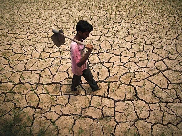
2.2.5.Drought
Drought conditions due to deficiency in
rainfall affect different parts of Bangladesh
mostly during the pre-monsoon
andpost-monsoon periods. Between
1949 and 1991, droughts occurred in
Bangladesh 24 times. Verysevere
droughts hit the country in1951, 1957,
1958, 1961, 1972, 1975, 1979, 1981, 1982,
1984 and 1989. Past droughts have
typically affected about 47% area of
the country and 53% of the population Figure 14: Drought
(WARPO, 2005). Bangladesh faces
unpredictable drought hazard in the dry monsoon due to inadequate and uneven rainfall. It
varies from place to place, however, and the northwestern regionsuffers most from the
drought. As much as 17% of the Aman crops, the main paddy crops in the wet season may be
lost in a typical year due to drought.
Figure 15: Drought Map
28ADRC Visiting Researcher Programme, FY2020, Country Report: Bangladesh
2.2.6. Earthquake
The historical seismic data of Bangladesh
and adjoining areas indicate that Bangladesh
isvulnerable to earthquake hazard. The
record of approximately 150 years shows
that Bangladesh and the surrounding regions
experienced seven major earthquakes (with
Mb =7). In the recent past, a number of
tremors of moderate to severe intensity had
already taken place in and around
Bangladesh. The Sylhet Earthquake (Mb =
5.6) of May 8, 1997, the Bandarban
Earthquake (Mb = 6.0) of November 21,
Figure 16: Earthquake Zones in Bangladesh
1997, the Moheshkhali Earthquake (Mb=
5.1) of July 22, 1999, the Barkal (Rangamati) Earthquake (Mb=5.5) of July 27, 2003, the
Meghalay Earthquake (Mb=5.2) of March 02, 2013 and many more shakes in the recent
years may be cited as examples. Bangladesh and the northeastern Indian states have long
been one of the seismically active regions of the world, and have experienced numerous
large earthquakes during the past 200 years. Many of seismic-tectonic studies have been
undertaken on the area comprising the Indo-Burmanranges and their western extension and
in the northern India.
Major active fault zones of the country have beendelineated through geological
trenching and dating methods. A seismic zoning map of Bangladesh has been proposed in
1979 by Geological Survey of Bangladesh (GSB) dividing the country into three seismic
zone which was accompanied by an outline of a code for earthquake resistant design.
Later, a new updated seismic zoning map and detailed seismic design provisions
have been incorporated in Bangladesh National Building Code (BNBC 1993).
A seismicity map of Bangladesh and its adjoining areas has also been prepared by
BMD and GSB. Bangladesh has been classified into three seismic zones with
zone-3 the most and zone-1 the least vulnerable to seismic risks.
29ADRC Visiting Researcher Programme, FY2020, Country Report: Bangladesh
Date Name Magnitude Epicentral Epicentral Epicentral
Distance Distance Distance
(Richter)
from from Sylhet from
Dhaka City (km) Chittagong
(km) (km)
10January,1869 Cachar 7.5 250 70 280
Earthquake
14 July, 1885 Bengal 7.0 170 220 350
Earthquake
12June, 1897 Great Indian 8.7 230 80 340
Earthquake
8 July, 1918 Shrimongal 7.6 150 60 200
Earthquake
2 July, 1930 Dhubri 7.1 250 275 415
Earthquake
15 January, Bihar-Nepal 8.3 510 530 580
1934 Earthquake
15 August, Assam 8.5 780 580 540
Earthquake
1950
Table 6: Major Earthquake
30ADRC Visiting Researcher Programme, FY2020, Country Report: Bangladesh
2.3. Recent Major Disasters
May 2020 - Tropical Cyclone Amphan
On 20 May 2020, Tropical Cyclone Amphan reached Bangladesh. As of 22 May, the
official death toll in Bangladesh was 17, with the UN estimating 10 million people and 19
districts were affected. GoB’s Early Warning system, the successful massive evacuations to
cyclone shelters respective of COVID-19 mitigation measures, and the power of the
mangrove forest of the Sundarbans contributed to reduce the impact of the cyclone and to
reduce the loss of lives as well as the damages to infrastructures. According to MoDMR
330,667 houses were damaged including 55,667 totally destroyed in nine most impacted
districts: Khulna, Satkhira, Barguna, Bhola, Patuakhali, Pirojpur, Noakhali, Bagerhat and
Jessore. Damage was mostly due to tidal surge causing embankments to collapse or
overflow. Bangladesh Armed Forces provided medical assistance, emergency rescue and
relief assistance. BDRCS provided food and emergency relief items in affected districts in
addition to funding the immediate repair of 200 tube-wells and for the rapid installation of
100 communal latrines. CSOs and NGOs are using their prepositioned items to contribute to
the relief efforts.
July 2019 – Monsoon Floods
Despite the delayed onset of the monsoon, heavy rainfall occurred during the first half of
July 2019 which triggered widespread flooding. Floods damaged and destroyed vital
infrastructures including 6,641 kilometers of roads, 1,275 bridges and culverts as well as
1,515 kilometers of embankments. With the support of the Ministry of Disaster Management
and Relief (MoDMR), the humanitarian community conducted a Joint Needs Assessment
(JNA). Among the 28 districts affected by the floods, the JNA report identified nine most
severely affected districts: Jamalpur, Kurigram, Gaibandha, Sylhet, Sirajganj, Tangail,
Sunamganj, Bogura, Bandarban. In those districts, 85% of the overall displacement occurred
equivalent to 261,499 persons including 57,406 school-age children (29,407 boys and
28,002 girls). Among the displaced population, 239,387 persons were living in makeshift
shelters (schools, colleges) or on embankments and some returned as water started to recede
31ADRC Visiting Researcher Programme, FY2020, Country Report: Bangladesh
in their areas. Associated riverbank erosion permanently displaced more than 8,000 people
equivalent to 1,654 households in Kurigram, Bogura and Tangail districts.131
July 2018 – Floods
On 25 July 2018, heavy monsoon rains caused landslides and flooding in the southeast,
killing five children near Cox’s Bazar and Ramu. Approximately 21,000 Rohingya refugees
in the camps were relocated because their shelters were threatened by landslides.
August 2017 – Floods
Heavy monsoon rains caused intense flooding across more than one-third of Bangladesh. The
Bangladesh Meteorological Department provided heavy rainfall warnings. As per the analysis
by the Ministry of Disaster Management and Relief (MoDMR), the floods were the worst in
the last four decades. Incessant heavy rainfall brought by the monsoon triggered flooding in
five divisions, 31 districts, 176 Upazilas and 1,173 Unions. Findings from the 72-hours
Needs Assessment were published on 21 August and they indicated that a total of about 6.9
million people (1.54 million households) were affected by the floods. National authorities
confirmed 114 deaths and 197,416 people were temporarily displaced in 703 community
shelters. As a result of the extensive floods, 77,272 houses were destroyed, 524,375 were
partially damaged. Findings of the 72-hours Needs Assessment also highlighted that in
northern Bangladesh, the following were the six worst-affected districts: Gaibhandha,
Dinajpur, Kurigram, Jamalpur, Nilphamari, Sirajganj. In these districts, a total of 330,000
people were displaced. Access to the most affected areas in the northwest was a challenge as
roads were either severely damaged or submerged under flood water. Approximately 9,000
km of roads, 500 bridges and culverts were damaged. Nearly 100 km of rail lines were
severely damaged by the floods. Around 714 km of embankments were also washed away.
June 2017 – Landslides
The June landslides, which started on 13th June with a few episodes, resulted in heavy loss of
life (160 persons), injury (187 persons), destruction of houses (6,000 structures), and other
key infrastructures despite being localized in impact. It was the worst landslide-related
32ADRC Visiting Researcher Programme, FY2020, Country Report: Bangladesh
disaster since 2007. It affected approximately 80,000 persons across five districts: Bandarban,
Chittagong, Cox’s Bazar, Khagrachari and, Rangamati. Among these people, 34, 000 were
severely impacted as they lost their houses together with their belongings, basic necessities,
livelihoods and food stocks.
2016 - Cyclone Roanu
On 21 May 2016, Cyclone Roanu made landfall in Bangladesh, about one week after it struck
Sri Lanka as a tropical storm. The cyclone caused the deaths of at least 27 people in
Bangladesh, though many more in Sri Lanka. Thanks to early warning systems, half a million
people were evacuated to shelters. Cyclone Roanu affected 1.3 million people, bringing
winds over 100 km/hour (62 miles/hour), heavy rain, and storm surges peaking at 2.7 meters
(8.9 feet).127 The Bangladesh Armed Forces were among the responders.
Cyclone Aila (May 2009)
Cyclone Aila hit the Bangladesh on Monday 25May 2009 and has
produced substantial damage across areas of southern Bangladesh. It caused 190
immediate deaths, injuries to 7,103 people and more than 500,000 people to
become homeless. The total damage was $ 1.7billion.
Cyclone Sidr (November 2007)
Cyclone Sidr hit the coastal areas on 15 November 2007. It affected 87,000
people, killed 3,363 and injured 55,282 and 564,000 homes have been destroyed
8,85,280 houses have been damaged. Total damage and losses were (in USD)
23billion.
Cyclone (April 1991)
On April 29, 1991, a cyclone struck the country of Bangladesh, causing a massive storm
surge and widespread flooding. Approximately 138,000 people perished in this
disaster. Although cyclones frequently hit this region of the world, this cyclone
was one of the strongest hurricanes in recent history. The 270 km/hr wind speed
33You can also read