Course Catalogue 2021-2022 - MSc GIMA
←
→
Page content transcription
If your browser does not render page correctly, please read the page content below
Course Catalogue

                                       2021-2022

Master of Science Geographical Information Management and Applications 2021-2022
Course Catalogue

                                                 Master of Science
                                               Geographical Sciences

              Geographical Information Management and Applications*

Delft University of Technology (TUD)
University of Twente (UT) - ITC
Utrecht University (UU)
Wageningen University & Research (WUR)

Year 2021-2022

July 2021

*This MSc programme is officially registered by the Utrecht University under the name Geographical Sciences (CROHO 60732)

     Master of Science Geographical Information Management and Applications 2021-2022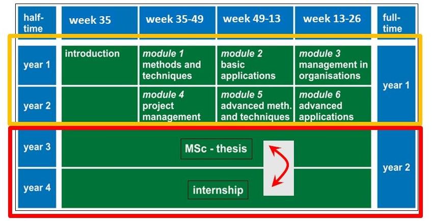
Preface

This Course Catalogue describes the Master of Science programme ‘Geographical Information Management and
Applications’ (GIMA), officially registered as the Master’ degree programme ‘Geographical Sciences’ at Utrecht
University (CROHO 60732) for the academic year 2021-2022.

The catalogue starts with an insight into the GIMA organisation and some practical information. The programme has
a modular structure, and uses a blended learning concept. Blended learning means a mixture of periods of face-to-
face contact and distance education. The face-to-face periods are required periods of attendance, so please keep an
eye on the overview with required periods of attendance for the current year on p. 6.

The first section of the catalogue (Part I: GIMA Course Guide) gives an overview of the course. It includes the details
of all course modules like name, code, time-slot, credits, coordinator and involved lecturers, learning objectives and
content, type of education, assessment procedure, entry requirements and literature. The module information may
be subject to some change. Therefore, during the programme, each module coordinator will provide you with a study
guide to update (if necessary) the module information. The GIMA Blackboard site (https://uu.blackboard.com) will
always offer the most up-to-date information. Change in a module described in a study guide overrules the module
information in the course catalogue. Part I further presents GIMA staff, the venues – including route descriptions –
and some frequently asked questions and answers.

The formal rights and obligations related to the programme follow in Part II: GIMA Regulations. The first two sections
contain regulations that are applicable to all Master degree programmes of the Faculty of Geosciences, Utrecht
University: the Education and Examination Regulations, followed by a GIMA specific part and the Model Regulations
of the Board of Examiners. The last section contains the additional Education and Examination Regulations of the
GIMA programme, which show the consequences of implementing all of these regulations in GIMA. Please note that
specific GIMA Internship Regulations and Master Thesis Regulations have been added to the respective module
descriptions.

Hopefully this GIMA Course Catalogue provides you with answers to the most important questions you have as a
student with respect to your GIMA studies. For additional questions and remarks, please do not hesitate to contact
me or the GIMA Secretary (gima.geo@uu.nl) or the GIMA Programme Director directly.

Good luck and enjoy the GIMA studies!

 Marco Helbichj
 GIMA Programme Director

 gima_pd@uu.nl

 Address:
     •    Postal address: Utrecht University, Faculty of Geosciences P.O. Box 80.115, 3508 TC Utrecht
     •    Visiting address: Utrecht University, Faculty of Geosciences, Vening Meinesz Building A, Princetonlaan 8a, 3584
          CB Utrecht (room 6.16)

     Master of Science Geographical Information Management and Applications 2021-2022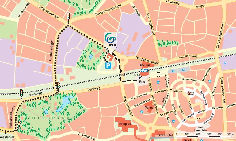
Table of Contents
Part I: GIMA Course Guide ....................................................................................... 9
General information ................................................................................................. 1
GIMA MANAGEMENT .................................................................................................................... 1
STUDENT FACILITIES ........................................................................................................................ 2
HOUSING ...................................................................................................................................... 2
SOCIAL LIFE.................................................................................................................................... 2
COMPUTERS & COMPUTER FACILITIES ................................................................................................ 3
OTHER PRACTICAL INFORMATION ...................................................................................................... 4
The Programme........................................................................................................ 8
CONTENT ...................................................................................................................................... 8
AIM AND LEARNING OUTCOMES ........................................................................................................ 8
LABOUR MARKET PERSPECTIVES ........................................................................................................ 9
PROGRAMME STRUCTURE ................................................................................................................ 9
ENTRY REQUIREMENTS .................................................................................................................. 10
RELATIONSHIP BETWEEN LEARNING OUTCOMES AND MODULE OBJECTIVES ............................................. 11
EVALUATIONS .............................................................................................................................. 12
MODULE 0: INTRODUCTION ........................................................................................................... 13
MODULE 1: BASIC METHODS AND TECHNIQUES ................................................................................ 14
MODULE 2: BASIC APPLICATIONS .................................................................................................... 16
MODULE 3: MANAGEMENT IN ORGANISATIONS ................................................................................ 18
MODULE 4: PROJECT MANAGEMENT............................................................................................... 20
MODULE 5: ADVANCED METHODS AND TECHNIQUES......................................................................... 23
MODULE 6: ADVANCED APPLICATIONS ............................................................................................ 25
MODULE 7: THESIS ....................................................................................................................... 27
MODULE 8: INTERNSHIP ................................................................................................................ 38
Staff Information ................................................................................................... 45
Course Venues ....................................................................................................... 53
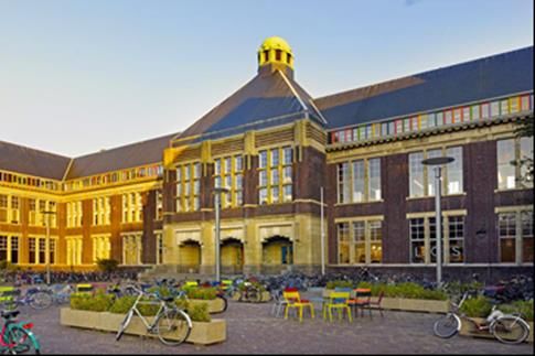
UNIVERSITY OF TWENTE - ITC......................................................................................................... 53
UTRECHT UNIVERSITY.................................................................................................................... 54
WAGENINGEN UNIVERSITY & RESEARCH .......................................................................................... 55
DELFT UNIVERSITY OF TECHNOLOGY ................................................................................................ 56
FAQ ........................................................................................................................ 57
Part II: GIMA regulations ....................................................................................... 65
SECTION 1 – GENERAL PROVISIONS ...................................................................... 67
ART. 1.1 – APPLICABILITY OF THE REGULATIONS ................................................................................ 67
ART. 1.2 – DEFINITION OF TERMS .................................................................................................... 67
SECTION 2 – ADMISSION ....................................................................................... 68
ART. 2.1 – ADMISSION REQUIREMENTS OF THE DEGREE PROGRAMMES .................................................. 68
ART. 2.2 – ENGLISH LANGUAGE (FOR MASTER’S DEGREE PROGRAMMES TAUGHT IN ENGLISH) .................. 68
ART. 2.3 – ADMISSIONS PROCEDURES .............................................................................................. 68
ART. 2.4 – DEFICIENCIES ................................................................................................................ 68
SECTION 3 – CONTENTS AND STRUCTURE OF THE DEGREE PROGRAMMES .............. 69
ART. 3.1 – AIM OF THE DEGREE PROGRAMMES .................................................................................. 69
ART. 3.2 – MODE OF ATTENDANCE .................................................................................................. 69
ART. 3.3 – LANGUAGE OF INSTRUCTION ........................................................................................... 69
ART. 3.4 – STUDY LOAD ................................................................................................................. 69
ART. 3.5 – PROGRAMMES; START DATES .......................................................................................... 69
ART. 3.6 – COMPONENTS OF THE MASTER’S PROGRAMMES ................................................................ 69
Master of Science Geographical Information Management and Applications 2021-2022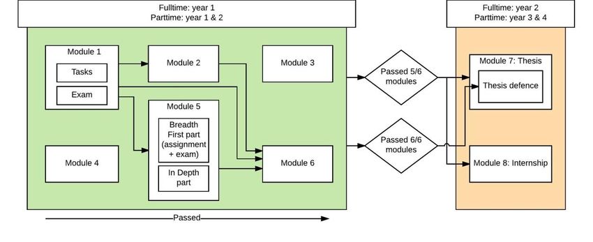
ART. 3.7 – COURSES TAKEN AT ANOTHER DUTCH RESEARCH UNIVERSITY ................................................ 70
  ART. 3.8 – COURSES TAKEN AT A FOREIGN RESEARCH UNIVERSITY ......................................................... 70
  ART. 3.9 – COMPONENTS TAKEN ELSEWHERE .................................................................................... 70
  ART. 3.9A - DESTINATION WITH NEGATIVE TRAVEL ADVICE ................................................................... 70
  ART. 3.10 – ACTUAL TEACHING STRUCTURE ...................................................................................... 71
SECTION 4 – COURSES ........................................................................................... 71
 ART. 4.1 – COURSE ....................................................................................................................... 71
 ART. 4.2 – COURSE ADMISSION REQUIREMENTS ................................................................................. 71
 ART. 4.3 – REGISTRATION FOR COURSES ........................................................................................... 71
 ART. 4.4 – ATTENDANCE AND EFFORT REQUIREMENTS ........................................................................ 71
 ART. 4.5 – PARTICIPATE IN COURSES; PRIORITY RULES ......................................................................... 72
 ART. 4.6 – COMPLETE COURSES FOR INTERNATIONAL STUDENTS BEFORE WINTER BREAK ........................... 72
 ART. 4.7 – EVALUATION OF THE QUALITY OF EDUCATION ..................................................................... 72
SECTION 5 – TESTING ............................................................................................ 72
 ART. 5.1 – GENERAL...................................................................................................................... 72
 ART. 5.2 – BOARD OF EXAMINERS ................................................................................................... 72
 ART. 5.3 – ASSESSMENT OF TRAINEESHIP OR RESEARCH ASSIGNMENT AND THESIS ................................... 73
 ART. 5.4 – GRADES ....................................................................................................................... 73
 ART. 5.5– REPEAT EXAMS: SUPPLEMENTARY TESTS ............................................................................. 73
 ART. 5.6– FORCE MAJEURE: REPLACEMENT TESTS .............................................................................. 73
 ART. 5.7 – TYPE OF TEST ................................................................................................................ 74
 ART. 5.8 – ORAL TESTS .................................................................................................................. 74
 ART. 5.9 – PROVISION FOR TESTING IN SPECIAL CASES ......................................................................... 74
 ART. 5.10 – TIME LIMIT FOR GRADING TESTS ..................................................................................... 74
 ART. 5.11 – PERIOD OF VALIDITY ..................................................................................................... 74
 ART. 5.12 – RIGHT OF INSPECTION .................................................................................................. 74
 ART. 5.13 – RETENTION OF TESTS .................................................................................................... 74
 ART. 5.14 – EXEMPTION ................................................................................................................ 74
 ART. 5.15 – FRAUD AND PLAGIARISM ............................................................................................... 74
 ART. 5.16 – CONTROL OF PLAGIARISM ............................................................................................. 76
 ART. 5.17 – RIGHT OF APPEAL ........................................................................................................ 76
SECTION 6 – EXAMINATION ................................................................................... 76
 ART. 6.1 – EXAMINATION .............................................................................................................. 76
 ART. 6.2 – CUM LAUDE CLASSIFICATION ........................................................................................... 76
 ART. 6.3 – DEGREE ....................................................................................................................... 77
 ART. 6.4 – DEGREE CERTIFICATE AND INTERNATIONAL DIPLOMA SUPPLEMENT (IDS) ............................... 77
 ART. 6.5 – GRADING TABLES........................................................................................................... 77
SECTION 7 – STUDENT COUNSELLING .................................................................... 77
 ART. 7.1 – STUDENT PROGRESS ADMINISTRATION .............................................................................. 77
 ART. 7.2 – STUDENT COUNSELLING .................................................................................................. 77
 ART. 7.3 – DISABILITY AND CHRONIC ILLNESS ..................................................................................... 77
SECTION 8 – TRANSITIONAL AND FINAL PROVISIONS .......................................... 78
 ART. 8.1 – SAFETY NET ARRANGEMENTS ........................................................................................... 78
 ART. 8.2 – AMENDMENTS .............................................................................................................. 78
 ART. 8.3 – PUBLICATION ................................................................................................................ 78
 ART. 8.4 – EFFECTIVE DATE ............................................................................................................ 78
Programme-specific part of the Education and Examination Regulations 2021-2022
.............................................................................................................................. 79
  ART. 2.1 - ADMISSION REQUIREMENTS ............................................................................................ 79
  ART. 3.1 – AIM OF THE DEGREE PROGRAMME ................................................................................... 79
     Master of Science Geographical Information Management and Applications 2021-2022
ART. 3.11 – FLEXSTUDY ................................................................................................................ 80
Regulations of the Board of Examiners ................................................................... 82
PARAGRAPH 1 – GENERAL STIPULATIONS ............................................................. 82
 ART. 1.1 – SCOPE OF APPLICATION .................................................................................................. 82
 ART. 1.2 – BOARD OF EXAMINERS .................................................................................................. 82
 ART. 1.3 – STANDARDS ................................................................................................................. 83
 ART. 1.4 - EXAMINERS................................................................................................................... 83
PARAGRAPH 2 – ORGANIZATION OF TESTS AND PROPER PROCEDURE ................... 83
 ART. 2.1 – TIMES OF TESTS ............................................................................................................ 83
 ART. 2.2 – REGISTRATION FOR TESTS ............................................................................................... 83
 ART. 2.3 – ORDER DURING A WRITTEN OR DIGITAL TEST ...................................................................... 84
PARAGRAPH 3 – ASSESSMENT OF TESTS, THESIS ................................................... 84
 ART. 3.1 – MARKING OF TEST ......................................................................................................... 84
 ART. 3.2 – ASSESSMENT OF THESIS, RESEARCH ASSIGNMENTS, GRADUATE THESES ................................... 84
 ART. 3.3 – SUBSEQUENT DISCUSSION............................................................................................... 84
 ART. 3.4 – RECORDING THE FINAL RESULTS ....................................................................................... 85
PARAGRAPH 4 – ASSURING THE QUALITY OF EXAMINATIONS ............................... 85
 ART. 4.1 – ASSURING THE QUALITY OF TESTING ................................................................................. 85
 ART. 4.2 – DETERMINING THE QUALITY OF TESTING ............................................................................ 85
 ART. 4.3 – DECLARATION OF INVALIDITY OF TEST FOR ALL PARTICIPANTS DUE TO QUALITY SHORTCOMINGS .. 85
 ART. 4.3A – DECLARING ONLINE PROCTORED TESTS INVALID IN THE EVENT OF IRREGULARITIES .................. 85
 ART. 4.4 – ASSURING THE QUALITY OF EXAMINATIONS (FINAL LEVEL OF THE GRADUATES) ......................... 86
 ART. 4.5 – BOARD OF EXAMINERS’ OWN INVESTIGATION TO MAINTAIN QUALITY OF EXAMINATION ............ 86
PARAGRAPH 5 - EXEMPTIONS, APPROVAL OF COURSE UNITS ................................ 86
 ART. 5.1 – EXEMPTION ................................................................................................................. 86
 ART. 5.2 – APPROVAL OF COURSE UNITS .......................................................................................... 86
PARAGRAPH 6 – COMPLAINTS ................................................................................ 87
 ART. 6.1 - COMPLAINTS ABOUT TESTING AND MARKING ..................................................................... 87
 ART. 6.2 - APPEAL AGAINST DECISIONS CONCERNING TESTING AND MARKING ......................................... 87
PARAGRAPH 7 – FINAL PROVISIONS...................................................................... 87
 ART. 7.1 – ANNUAL REPORT ........................................................................................................... 87
 ART. 7.2 – AMENDMENTS.............................................................................................................. 88
 ART. 7.3 – ENTERING INTO FORCE AND PUBLICATION ......................................................................... 88
GIMA Additional Examination Regulations to the Regulations of the Board of
Examiners .............................................................................................................. 88
PARAGRAPH 5 - EXEMPTIONS, APPROVAL OF COURSE UNITS ................................ 88
 ART. 5.1 – EXEMPTION ................................................................................................................. 88

     Master of Science Geographical Information Management and Applications 2021-2022
Part I: GIMA Course Guide

Master of Science Geographical Information Management and Applications 2021-2022

Part I: GIMA Course Guide

General information
This chapter gives an overview of the organisation and administrative structure of the GIMA studies and student
facilities.

GIMA Management
The management of GIMA consists of a Programme Board, a Programme Director, a Programme Committee, an
Admission Committee and a Board of Examiners. The GIMA Secretary supports their functions. The contact details for
the members mentioned hereafter can be found in the staff information section.

Programme Board
Prof. Dr. Ir. Peter van Oosterom (TUD,Chair)
Prof. Dr. Dick Ettema (UU)
Prof. Dr. Menno-Jan Kraak (UT-ITC)
Dr. Ron van Lammeren (WUR)

Programme Director
Dr. Marco Helbich (UU)

Programme Committee
The Programme Committee consists minimally of four staff members and four student members.
Members (until October 1, 2021):
Dr. Ir. Arend Ligtenberg (staff, WUR, chair)
Stijn Mars (student, 2021)
Dr. Frank Ostermann (staff, UT)
Shiyuan Zhang (student, 2019)
Dr. Ir. Bastiaan van Loenen (staff, TUD)
Remco Logtenberg (student, 2021)
Mattijs de Haas (student, 2019)
Dr. Simon Scheider (staff, UU)

You can contact the programme committee at: programmecommittee.gima@gmail.com

Admission Committee
Prof. Dick Ettema (UU)
Dr. Marco Helbich (UU)

GIMA Secretary
Daan de Visser
Any questions regarding this Course Catalogue or other facets of GIMA may be directed to the GIMA Secretary, over
e-mail. The e-mail address is gima.geo@uu.nl.

Board of Examiners
The Board of Examiners can be contacted to request certain approvals e.g. for exemptions, substitutions, your study
programme, or to take additional courses outside the Faculty of Geosciences. Send an email from your UU-Gmail
(include your name, study programme and student number) to boardofexaminers.geo@uu.nl

    Master of Science Geographical Information Management and Applications 2021-2022                           1
Part I: GIMA Course Guide
Student facilities
As a GIMA student you are registered at Utrecht University (UU), this means that the facilities of the Faculty of
Geosciences of UU are accessible for GIMA students. Most questions regarding UU facilities can be addressed at:
qdesk.uu.nl (both English and Dutch). For access to facilities at other universities, application forms are available at
that specific institute.
Library
As a GIMA student you are entitled to the use of the library of the Utrecht University or of the University of Twente.
You can find more information about the library in Utrecht at: www.library.uu.nl. The website of the University of
Twente is: http://www.utwente.nl/ub/ During your registration as a ‘Bijvak’ student at Wageningen University you
can also make use of their library. At these libraries you can find scientific articles online when you use your student
number and password. The libraries also provide study facilities and you can also lend books.
Study Advisor
Since GIMA is based in Utrecht the Study Advisor is based here as well. The Study Advisor can advise you on study-
related matters. Please also check https://students.uu.nl/en/geo/gima/contact/study-advisor how to make an
appointment.
• Email address: studieadviseur.sgpl@uu.nl
• Phone number: +31 (0)30 253 3739
Student Psychologist
If you are a Dutch student you can schedule an appointment yourself (information in Dutch). If you are an
international student, please contact Student Services either by phone or in person – not by e-mail – and schedule an
introductory meeting. During the introductory meeting, the Student Psychologist will investigate your problem. This
will involve focusing on your personal background. Sometimes that initial meeting will be sufficient to assist you with
your problem, sometimes more will be required.
• It may be suggested to start a series of individual meetings, with the aim of further clarifying your problem
and identifying the best approaches to address it.
The student psychologists work according to a short-term support model. In general, a series will involve
no more than five meetings. The meetings are strictly confidential and free of charge.
• You may also receive a referral to a person or institution within or outside the university.
More information can be found in this link.
Misconduct – Confidential Counsellor
The university’s Code of Conduct (see: Regulations) is designed to prevent misconduct. Misconduct may include
sexual intimidation, aggression, violence and discrimination. More information can be found in this link. It discusses
actions to be taken and the contact details of the confidential counsellor.
Housing
Students who plan on staying in the Netherlands for the entire duration of the programme can request to arrange
housing via the international office of UU (international@geo.uu.nl). But arranging housing yourself somewhere else
in the Netherlands is also possible. For hotels to stay specifically during the contact days students may ask the GIMA
Secretary about the cheapest locations in the neighbourhood of the participating institutions.
Social life
NODE
NODE is the student association of GIMA. NODE was founded in 2015 by a group of GIMA students. NODE wants to
create and become part of a network between (GIMA) students, alumni and external parties. In order to do this, it
has created several objectives. It strives to improve communication, integration and interaction between students in
different GIMA years. Besides, it wants to create a foundation for informal social interaction between GIMA students
by organizing social activities during the GIMA contact weeks. On top of that it wants to establish a network between
GI master students in the Netherlands and beyond. NODE can be contacted via email address gima-node@uu.nl.
Erasmus Student Network
International students staying in the Netherlands during the entire GIMA programme receive information about the
Erasmus Student Network (ESN) together with their acceptance letter. This will help students to overcome any
cultural differences and to establish a social network in the Netherlands. Also Utrecht has a very active entity of the
European Geography Association for students and young geographers (EGEA), which organizes a lot of extra-curricular
activities.
Master of Science Geographical Information Management and Applications 2021-2022 2Part I: GIMA Course Guide
Computers & computer facilities
Due to the blended-learning nature of the GIMA Master programme, all students are required to have a laptop,
starting their first day at GIMA in September, which meets the requirements stated below in order to properly execute
the software used during the master. Software that is required for all GIMA participants will be provided. Microsoft
Office is also required. Once you have been registered at the Utrecht University, you can download it for free at via
this URL. It is also important to mention that service and computer help at the universities, as well as most of the
software needed during the master course, is based around Windows operating systems. Although you are free to
make your choice of laptops, you need to be aware that services and software often might not work for, for instance,
a Mac.
Hardware and operating system requirements
Minimum Recommended
Operating system Windows 10 64 bit English (Home premium, Ultimate, Pro, (Minimum)
Enterprise)
Memory 8 GB 16 GB
Disk storage 80 GB free disk space (Minimum)
Screen 15 inch, 1366 x 768 (Minimum)
Processor Intel® Core™ i3 Processor or equivalent (e.g. AMD) (Minimum)
Network Wireless (Wi-Fi) and Ethernet LAN (Minimum)
Mouse Separate mouse with left/right click and centre wheel (Minimum)
Software Microsoft Office 2010 (Minimum)
Computers available at the Universities
It is also possible to get access to computers in labs of the different universities. At the universities of Utrecht and
Wageningen, computers with GIS software can be accessed. To receive a login for Wageningen, you must enrol as a
minor student at Wageningen University. See also ‘registration overview’ on page 5. The GIS-lab in Utrecht is located
in the Vening Meinesz Building A (Princetonlaan 8a). Login for the GIS-lab can be obtained via Maarten Zeylmans
(m.j.zeylmansvanemmichoven@uu.nl).
Registration of marks: Osiris (accessible via www.osiris.universiteitutrecht.nl)
Osiris is the education registration system of Utrecht University. Via the Internet you can log in and see your official
marks. For login you have to use your UU student number and password.
Blackboard (accessible via www.uu.nl/blackboard)
Blackboard is the education platform we use and runs via Utrecht University. It will be used extensively in GIMA. Via
the Internet you can log in with the username (student number) and password you have received from UU. This
system will be used for all GIMA modules; here you can find information on the modules, lectures, a discussion board,
the most current regulations, etc. It is also used for communication between staff and students, either via email or
announcements in the GIMA General Information community on Blackboard. This contains information that is not
specific for a particular GIMA module. Amongst others, the timetables of the contact days are published here. The
Course Catalogue is also accessible via the GIMA General Information community.
Each module of GIMA has its own Blackboard space. The naming convention is as follows: [Course year] [module
number] / [module name] / [exam code]. This means that each year a new Blackboard module will be created for
every module. The only exceptions to this rule are module 7 (Thesis) and 8 (Internship). These remain the same every
year, but are continuously updated. They appear as communities. All registered GIMA course participants have access
to Blackboard modules 7 and 8 (right from the start of the GIMA programme) where you can find, for instance, all
GIMA theses which have been produced over the past 18 years, newly suggested thesis research topics plus an
overview of the current GIMA thesis researchers and their topics, and internship options.
If you don’t have access to a certain module you may contact the GIMA Secretary at gima.geo@uu.nl.
Master of Science Geographical Information Management and Applications 2021-2022 3Part I: GIMA Course Guide
Student mail
As a GIMA student you receive two email accounts, one from Utrecht University and one from the University of
Twente. As the UU account is linked to Blackboard, this UU email account will always be used for communication
between students and GIMA staff. To prevent missing any important information, it is advised to automatically
forward emails from both accounts to your personal email address.
Student Service Centre
GIMA students can turn to Student Affairs of the Faculty of Geosciences of Utrecht University for information, advice
and services on studying. Student Affairs is located at Budapestlaan 4a-b, Utrecht. Also you can submit questions
regarding admission requirements and registration via studentaffairs.geo@uu.nl.
Surfspot
You are entitled to buy software at a discount at Surfspot (http://www.surfspot.nl/) or directly at the Faculty of
Geosciences (http://geo-ict.geo.uu.nl/software/surfspot.htm) (the last one has a limited selection of software). For
login, use your UU student account.
Educational Software
As a GIMA student you will acquire a student license of ArcGIS. This advanced license includes the extensions Spatial
Analyst, Geostatistical Analyst 3D Analyst and more. Help with installation of this software will be provided during
the first contact week. Furthermore, during some modules additional software packages will be provided, depending
on the chosen subject.
Other practical information
More comprehensive information is to be found in the manual on administrative procedures (also called the manual
for registration and access to the services on the various institutes) on Blackboard, or on our website www.msc-
gima.nl.
Registration
Since four universities are involved in the GIMA programme, the registration procedure might be confusing for
prospective students. The following needs to be done: a student will first apply for the MSc GIMA via Studielink
(www.studielink.nl). The student will receive (if accepted) a letter of acceptance or conditional acceptance. A
confirmation letter is attached as well.
Please send this confirmation letter back as soon as possible to confirm that you are going to attend GIMA. With the
letter of (conditional) acceptance, the student can register him/herself at Utrecht University. Payment of the tuition
fees is part of the registration.
Master of Science Geographical Information Management and Applications 2021-2022 4Part I: GIMA Course Guide
IMPORTANT – RE-REGISTRATION AT UTRECHT UNIVERSITY IS REQUIRED EACH YEAR!
Re-registration by Studielink at Utrecht University has to be done every year, before August 31st. Failing to do so
can have serious consequences for your participation in the programme (e.g. module results will not be filed
because they become invalid, educational support and course facilities will not be available).
Questions regarding re-registration can be asked via www.qdesk.uu.nl
!!! Please note that you cannot register through the GIMA administration (Programme Director or GIMA
Secretary). A student has to register him/herself with Utrecht University !!!
Completion of MSc GIMA programme
Upon completion of the GIMA programme, you can apply for graduation by filling the form here:
http://www.formdesk.com/universiteitutrecht/GEO_applyforMAgraduation. You can use the form to indicate how
you would like to receive your diploma: in a graduation ceremony, or sent by mail carrier. Wait with de-registering
until you have received a confirmation! All information about graduation can be found here:
http://students.uu.nl/en/geo/gima/practical-information/graduation
From this moment, Utrecht University takes over the administration completely. GIMA only wants to know whether
you would like to receive your diploma in a graduation ceremony.
Termination of the MSc GIMA Programme
If, for some reason, you choose to stop with GIMA while you have not finished the entire programme, you should
inform the Programme Director. In such cases, it is possible to request a certificate of the completed modules.
Request this through the GIMA Secretary (gima.geo@uu.nl).
Tuition fee refund
It is possible to get a refund of part of your tuition fee if you finish the MSc programme before the end of the academic
year. You are advised to have a look at the www.qdesk.uu.nl website; the steps required to stop with GIMA and
possibly have a refund of tuition fees are all described there.
WUR ‘bijvakkers’ registration
All students who are in modules 3 and/or 6, or who have a supervisor from Wageningen University for their thesis or
internship, need to register as a ‘bijvakker’ at Wageningen University.
• For 1st year students in modules 3 and 6 this implies that you will have to fill in a ‘bijvakkers’-form and send
a copy of your ID or passport. Your proof of paid tuition will be sent directly by Utrecht University to the
Wageningen University. The filling in of the ‘bijvakkers’-forms and collecting the copies of ID’s will be
handled during Module 0.
• 2nd year and older students
o who still have to follow modules 3 and/or 6 or
o who have a thesis and/or internship supervisor form Wageningen University
will have to register themselves as ‘bijvakker’ by requesting a ‘proof of payment of the tuition fees’ (Bewijs
Betaald Collegegeld) at Utrecht University1, filling the bijvakkers’ form2 (on which you clearly indicate that
you are a GIMA student). The form and a copy of your ID or passport may be sent to ssc@wur.nl. However,
the Proof of payment tuition fees has to be sent by regular mail (not email, we need the originals) to:
Wageningen University
Student Service Centre (SSC)
FORUM
Droevendaalsesteeg 2
6708 PB Wageningen
1Mail to infob@qdesk.uu.nl for a request for proof of paid tuition fee with your name, address, date of birth, and
Utrecht University Solis-ID and indicate that your MSc programme is GIMA.
2 Some suggestions for the form: You are not required to fill out the WUR registration number as you do not have
one; Duration from today until 31 AUG ; institution is Utrecht University; Faculty Geosciences,
GIMA; person: -; Postal address: P.O. Box 80.115, 3508 TC Utrecht; Telephone: (+31) 30 2532024; Email:
info@geo.uu.nl your type of registration: part time / full time.
Master of Science Geographical Information Management and Applications 2021-2022 5Part I: GIMA Course Guide
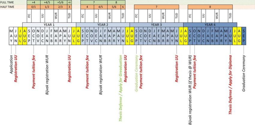
To summarize all registration moments, see the Figure below.
Master of Science Geographical Information Management and Applications 2021-2022 6Part I: GIMA Course Guide
Required periods of attendance: academic year 2021 – 2022**GIMA schedule 2021 – 2022
Week Date Activity Where
31 August 2021
GIMA introduction (Module
1 September 2021
35 0)
2 September 2021
3 September 2021
ITC/UT
6 September 2021 Module 1 start
Enschede
7 September 2021
36 8 September 2021
°9 September 2021 Module 4 start
* 10 September 2021
37-48 Distance Learning
6 December 2021
Module 1 end
7 December 2021
49 °8 December 2021
Module 4 end
*9 December 2021
10 December 2021 Utrecht
13 December 2021 Module 2 start University
14 December 2021
50 15 December 2021
16 December 2021 Module 5 start
17 December 2021
51-1 No Teaching
2-12 Distance Learning
28 March 2022
Module 5 end
29 March 2022
13 30 March 2022
Module 2 end
° 31 March 2022
Wageningen
• 01 April 2022
University
04 April 2022 Module 3 start
05 April 2022
14 06 April 2022
07 April 2022 Module 6 start
08 April 2022
15-25 Distance Learning
27 June 2022
Module 3 end
28 June 2022
* 29 June 2022
26 Module 6 end TU Delft
30 June 2022
Modules 7 and 8:
° 1 July 2022
introduction
4 July 2022
5 July 2022
27 6 July 2022 Preparing for Module 7 or 8 Self-study
7 July 2022
8 July 2022
* Midterm presentations, thesis defences, graduation ceremony
° Reserve day for midterm presentations and thesis defences
** Please note that the schedule may be subject to changes if the situation
concerning the Covid-19 virus demands so.
Master of Science Geographical Information Management and Applications 2021-2022 7Part I: GIMA Course Guide
The Programme
Content
There are a number of special features that give the GIMA programme a unique character: a large part of the
programme is offered as distance learning. Only the first and the last week of each module are classroom learning.
The remaining time you will work from your home or office, whether in the Netherlands or somewhere else. The
interactivity will be guaranteed by the use of electronic communication (Blackboard e-learning environment and
other means) by which you regularly interact with your teachers and fellow students. The use of various ICT means
and didactic tools add to the attractiveness of the programme.
The programme has a high degree of flexibility and “knowledge on demand”. The programme is developed in co-
operation between four renowned universities, each with its own tradition:
- Utrecht University (UU), with a focus on geography and planning;
- Delft University of Technology (TUD), with a focus on the legal, organisational and technical aspects of geo-
information handling with an emphasis on large scale applications;
- University of Twente (Faculty of Geo-Information Science and Earth Observation) (UT-ITC), with a focus on
technical and application oriented courses, all dealing with GIS and Remote Sensing, mainly for developing
countries;
- Wageningen University (WUR), with a focus on geo-information items related to land use, agricultural and rural
applications.
The different approaches of the four universities will provide you with an optimal mix of GI knowledge and skills.
The programme is offered in a full-time mode of 2 years (study load approx. 40 hrs per week) and a part-time mode
of 4 years (study load approx. 20 hrs per week).
If you want to join the GIMA programme you have to meet these requirements:
- Bachelor degree in relevant field of science;
- Academic skills on par with those expected at the level of a university Bachelors’ degree;
- Basic knowledge of and practical experience in geo-information;
- English language proficiency (the MSc programme is an international programme; therefore, education will be
offered in English).
Aim and learning outcomes
The aim of this inter-university MSc-GIMA programme is to educate suitable candidates to become highly skilled and
all-round geo-information managers and/or application specialists. Therefore, the candidates will be introduced into
the theoretical, methodological, technological, and organisational principles of working with geographical
information (GI), together with the use of GI-technology in spatial applications. The learning outcomes are described
below.
The graduate is able to:
DOMAIN SPECIFIC
1. Identify and understand geo-information concepts, methods and techniques.
2. Use appropriate concepts, methods and techniques for the management and application of geo-information.
3. Analyse the quality and usability of geo-information processes.
4. Evaluate solutions for societal problems by applying knowledge of geo‐information.
5. Design and implement proof-of-concept geo‐information-based solutions for societal problems.
SCIENTIFIC
6. Independently formulate and execute research in accordance with academic standards within the field.
7. Communicate clearly (both orally and in writing) with specialists and non-specialists to present and discuss
the outcomes of research and design projects.
8. Show awareness of the need to keep in touch with relevant developments within the discipline and show the
ability to recognize, understand and apply new concepts and approaches as they emerge.
9. Demonstrate understanding of the moral and ethical dimensions of scientific research and its applications,
and the importance of intellectual integrity.
GENERAL LEARNING OUTCOMES
10. Effectively organize, structure and plan phases in multidisciplinary teamwork.
11. Critically reflect on own performance and results, as well as on those of colleagues.
Master of Science Geographical Information Management and Applications 2021-2022 8Part I: GIMA Course Guide
12. Design and plan a path to study in Geo-Information Science in a manner that is largely self-directed or
autonomous.
Labour market perspectives
The MSc-GIMA programme aims at educating students to become all-round managers of geo-information or all-round
geo-information application specialists. They will work in the private sector (utilities, oil companies, geo-marketing,
consulting), the public sector (research institutes, municipalities, central and regional government services) and all
combinations of these two. In recent years the demand for managers and application specialists in geo-information
on the professional GIS market increased enormously.
With the MSc programme Geographical Information Management and Applications (GIMA) you can qualify for these
professions, as you will acquire:
- Knowledge and skills of management; ‘how to manage geo-information (projects/organisations)’,
- Knowledge of geo-information application fields; ‘where to apply geo-information’,
- Technological and methodological geo-information skills; ‘how to use geo-information technology’
Programme Structure
The programme can be followed full time or halftime.
The programme consists of six modules: 1) basic GI-methods and techniques; 2) basic GI-applications; 3) management
in organisations; 4) management of GI-projects; 5) advanced GI-methods and techniques; 6) advanced GI-
applications. Thereafter the MSc-GIMA programme consists of an MSc-thesis and an internship.
In the Osiris course list (Utrecht University course system) you will find the following codes and names:
Course code Title ECTS-credits
GEO4-GIMA1 Basic methods and techniques 10.0
GEO4-GIMA2 Basic applications 10.0
GEO4-GIMA3 Management in organisations 10.0
GEO4-GIMA4 Project management 10.0
GEO4-GIMA5 Advanced methods and techniques 10.0
GEO4-GIMA6 Advanced applications 10.0
GEO4-GIMA8 Master thesis GIMA 30.0
GEO4-GIMA7 or Internship GIMA/ 30.0 or
GEO4-GIMA9 Internship GIMA + additional courses 20.0 + 10.0
Additional information on the courses is available on Blackboard (www.uu.nl/blackboard) and on the web (www.msc-
gima.nl). Your UU student number is your login name for Blackboard.
Master of Science Geographical Information Management and Applications 2021-2022 9Part I: GIMA Course Guide
Entry Requirements
Besides the letter of acceptance for the GIMA programme, some entry requirements have to be met for certain
modules.
These entry requirements are explained in more detail in the course descriptions.
Master of Science Geographical Information Management and Applications 2021-2022 10Part I: GIMA Course Guide
Relationship between learning outcomes and module objectives
The table on the following two pages illustrates how the objectives of each of the modules (which are described in
the next section) relate to the GIMA learning outcomes.
GIMA programme learning outcomes
Independently formulate and execute research
Information Science in a manner that is largely
present and discuss the outcomes of research
in accordance with academic standards within
Show awareness of the need to keep in touch
writing) with specialists and non-specialists to
Demonstrate understanding of the moral and
ethical dimensions of scientific research and
geo‐information-based solutions for societal
Evaluate solutions for societal problems by
results, as well as on those of colleagues
Critically reflect on own performance and
understand and apply new concepts and
Use appropriate concepts, methods and
Identify and understand geo-information
Design and plan a path to study in Geo-
Analyse the quality and usability of geo-
Communicate clearly (both orally and in
Design and implement proof-of-concept
Effectively organize, structure and plan
applying knowledge of geo‐information
its applications, and the importance of
with relevant developments within the
phases in multidisciplinary team work
techniques for the management and
concepts, methods and techniques
discipline and is able to recognise,
application of geo-information
self-directed or autonomous
approaches as they emerge
Course (module) objectives
information processes
and design projects
intellectual integrity
problems
the field
1 2 3 4 5 6 7 8 9 10 11 12
No. Code Course The graduate will / will be able to: Domain-specific learning outcomes Scientific learning outcomes General learning outcomes
1 GEO4-GIMA0 Gain understanding of the nature of the GIMA course.
2 M0 Understand that different approaches toward geo-informatics are possible. X
3 M0 Understand why geo-information is needed to solve problems. X X
Introduction
Obtain practical knowledge on how to use learning and communication tools
4 M0 X
the GIMA distance-learning mode.
5 M0 Improve GIS skills. X
Describe and understand the basics of the geo-information process, including
1 GEO4-GIMA1 X X X X
the role of data modelling.
Understand the principles of data acquisition (including an introduction in
2 M1 X X X X
Remote Sensing), data storage, data analysis, and visualization technologies
3 M1 Basic Methods Understand the basics of quality issues of geo-information. X X X X
4 M1 and Techniques Apply basic methods in handling geo-information using the ArcGIS software. X X
5 M1 Apply basic skills in searching and validating scientific literature. X X
Analyse basic problems, decide on solutions and summarize findings in a in
6 M1 X X X X
technical report.
7 M1 Create a research proposal. X X
Demonstrate practical experience in basic methods and techniques for geo-
1 GEO4-GIMA2 X X
data handling.
Show critical awareness of the influence of data quality aspects on the
2 M2 X X X X X
Basic outcomes of the GI application project.
3 M2 Applications Show practical experiences with integrated software handling. X X
Demonstrate the practical integration and application of knowledge of module
4 M2 X X X X X X
1 (basic methods and techniques) into a GI application project.
5 M2 Integrate existing scientific knowledge into a case-study oriented GI-project. X X X X X
Demonstrate a scientific, critical-methodological and ethical attitude
6 M2 X X X X X X X X X
concerning geo-data handling in practical situations.
Remember key GI-organisations, their differences, their roles and their scale
1 GEO4-GIMA3 X
level of application.
Remember and understand the principles of management science and
management information sciences and apply the organisational resources
2 M3 X X X
(Software, Hardware, ‘Humanware’, ‘Dataware’ and ‘Orgware’) to GI-
organisations.
Understand the concepts, processes and main components of spatial data
3 M3 Management in infrastructures and their requirements to support data sharing between GI- X X
organisations organisations.
Apply the main methods and tools for organisation (infrastructure) planning,
development and management through the application of a SWOT analysis
4 M3 X X X X
(Strengths, Weaknesses, Opportunities and Threats), and a cost-benefit
analysis.
5 M3 Evaluate the existing management of GI of an organisation. X X
6 M3 Create and present a business plan for the management of a GI-organisation. X X X X X X X X X
Describe and position projects and project management within an
1 GEO-GIMA4 X X
organizational and a scientific setting.
Acquire and apply key project management knowledge and skills necessary to
2 M4 X X
initiate, plan, control and direct a GI related project.
GeoInfo project
Identify, specify, organize and evaluate key project management aspects and
management
3 M4 elements contributing to a valid GI related project proposal based on prior X X X X
given requirements and constraints.
Demonstrate his/her ability to write an academic paper within the project
4 M4 X X X X
management domain according to prescribed writing guidelines.
Have an overview of simple and advanced spatial data models and
1 GEO4-GIMA5 X X X X
understand which model serves which purpose.
Be proficient in elementary (query) spatial data operators, in both raster and
2 M5 X* X* X* X*
vector domain.
3 M5 Advanced Understand and be able to set up and carry out spatial computations. X* X* X* X*
4 M5 Methods and Understand the principles of spatiotemporal modelling in GIS. X* X* X* X*
techniques Understand, and to some extend apply, the principles of spatial planning
5 M5 X* X* X* X*
support.
Understand how geodata can be made public using visualization technology
6 M5 X* X* X* X*
developed for the internet.
7 M5 Have specialized themselves in one of the offered in-depth study topics. X* X* (4,6) X* X*
1 GEO4-GIMA6 Integrate knowledge and skills of the previous modules (1, 2, 4, 5). X X X X
Apply project management and progress monitoring skills to prepare, plan,
2 M6 X X
execute, manage and monitor a GIS project.
Independently use appropriate GI techniques and methods in the context of
X X
specific applications.
Advanced
Independently use appropriate GI techniques and methods in the context of
3 M6 applications X X
specific applications.
Present the methodology and results in an appropriate manner for a specific
4 M6 X X X
context.
5 M6 Develop a critical attitude towards data and data processing methods. X X
6 M6 Evaluate organisational restraints and consequences. X X
Demonstrate his/her ability to use and integrate knowledge and competences
acquired in the six modules and possibly the internship for an advanced,
1 GEO4-GIMA8 X X X X X X X
master level research, development and/or design project that adheres to
Thesis international scientific standards and shows originality and scholarship.
Demonstrate his/her ability to present the process and the results of the
2 M7 project in both written and oral format and to defend and discuss one’s work in X X
conformity with international scientific conventions.
Applied in practice and tested the theoretical and practical knowledge
1 GEO4-GIMA7 accumulated in modules 1 – 6. The modules contributed to mastering the X X X X X
student’s syllabus and improving the student’s basis for graduation.
Internship Acquired or increased technical experience, insight into business, and social
2 M8 X X X
and other skills.
Been given the opportunity to become familiar with a geo-information
3 M8 X X X X X
workplace.
X Course objective contributes to a GIMA programme learning outcome
X* Contribution of the course objective to a GIMA programme learning outcome depends on selected topic
Master of Science Geographical Information Management and Applications 2021-2022 11Part I: GIMA Course Guide
GIMA programme learning outcomes (columns 1 to 12):
DOMAIN SPECIFIC
1. Identify and understand geo-information concepts, methods and techniques.
2. Use appropriate concepts, methods and techniques for the management and application of geo-
information.
3. Analyse the quality and usability of geo-information processes.
4. Evaluate solutions for societal problems by applying knowledge of geo‐information.
5. Design and implement proof-of-concept geo‐information-based solutions for societal problems.
SCIENTIFIC
6. Independently formulate and execute research in accordance with academic standards within the field.
7. Communicate clearly (both orally and in writing) with specialists and non-specialists to present and discuss
the outcomes of research and design projects.
8. Show awareness of the need to keep in touch with relevant developments within the discipline and is able
to recognise, understand and apply new concepts and approaches as they emerge.
9. Demonstrate understanding of the moral and ethical dimensions of scientific research and its applications,
and the importance of intellectual integrity.
GENERAL LEARNING OUTCOMES
10. Effectively organize structure and plan phases in multidisciplinary team work.
11. Critically reflect on own performance and results, as well as on those of colleagues.
12. Design and plan a path to study in Geo-Information Science in a manner that is largely self-directed or
autonomous.
Evaluations
All GIMA Modules include an evaluation at the end of the module in order to improve the education programme. A
specific protocol is being followed. It consists of an online evaluation survey, oral student evaluation and online
teacher evaluation, for module 1-6. Since module 7 and 8 divert in nature they will follow their own evaluation
procedures. Evaluations are to be discussed in the programme committee and published on blackboard in the General
Information module.
Master of Science Geographical Information Management and Applications 2021-2022 12You can also read