Welcome - City of Hamilton
←
→
Page content transcription
If your browser does not render page correctly, please read the page content below
Claremont Access Openhouse
August 16, 2016
Claremont Access
Welcome
In January 2016, City Council directed staff to investigate
design options for a cycling facility on the Claremont
Access. Pedestrian accommodations are also considered.
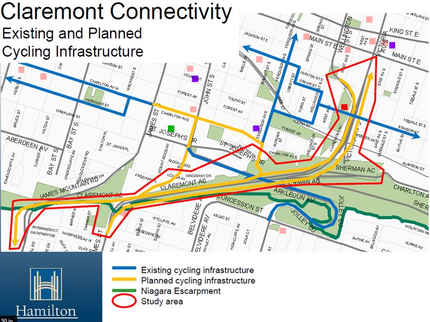
The study area is about 2.5 km long, from the base of the
Claremont Access near Wellington Street to Upper James
Street and continuing along the Brow to West 5th Street.
The study also includes possible linkages along this route
to parks, trails, and intersecting streets.
Hamilton's Cycling Master Plan proposes various forms of
infrastructure along this corridor, including bike lanes and
multi-use trails, to provide a safer, efficient, and
comfortable network to encourage cycling.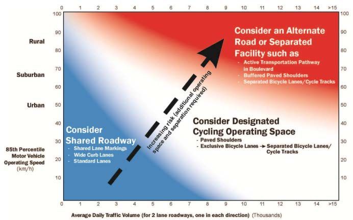
Claremont Access Openhouse
                                                                                   August 16, 2016
Background Planning

   • Transportation Master Plan (TMP) 2007
         - Stated target: 15% active transportation mode share (all daily
             trips) within 20-30 years.

   • Cycling Master Plan (CMP) – Shifting Gears 2009
         - Develop a city wide cycling network for all types of cyclists
             (commuter, utilitarian, and recreational) through the
             expansion of on-road and off-road cycling facilities,
             including escarpment crossings;
         - Design facilities that are appropriate for the traffic volumes
             and speed of the road;
         - Provide convenient and all-season access to major
             residential and employment areas and transit nodes.
         - Claremont Access connections in the current CMP:

 BL = Bike Lane, MurT = Multi-use Recreational Trail, red text indicates the link spans multiple wards

   • Recreational Trails Master Plan (RTMP) 2016
         - Integrate new trail accesses, routes, and crossings of the
              Niagara Escarpment with existing and planned
              infrastructure;
         - Integrate off-road trails with the planned on-road cycling
              network.

   As a result of the visions and objectives of the above master plans,
   a study to conceptually design and cost a cycling facility on
   the Claremont Access, including a number of possible
   connections to existing facilities, was initiated by the City.
Claremont Access Openhouse
August 16, 2016
Alternatives
• Possible locations for a cycling facility:
1) Two-way in up-bound lanes / north side only;
2) Two-way in down-bound lanes / south side only;
3) Up-bound on north side and down-bound on south side.
• Locations were evaluated based on safety, cost, and
connectivity to parks and existing active transportation facilities.
1) Two-way in up-bound lanes / north side only
This location provides active transportation access with reduced
exposure to auto traffic, avoiding crossings of merging traffic (i.e.
Charlton Avenue off-ramp and Victoria Ave at Main St).
This location offers desirable connections to:
• St. Joseph’s Healthcare – West 5th Campus;
• West 5th Street and Mohawk College;
• Southam Park;
• James Street stairs;
• John Street pathway/Bruce Trail;
• Arkledun Ave/ Jolley Cut (bike lane and sidewalk);
• St. Joseph’s Drive;
• Escarpment Rail Trail;
• Existing on-street cycling infrastructure in the lower city.
2) Two-way in down-bound lanes / south side only
Does not provide the connectivity of the north side option, including
connections to West 5th Street. It does, however, provide direct
connection to Upper James Street at Rosedene Avenue, and Victoria
Avenue at Main Street.
3) Up-bound on north side and down-bound on south side
Does not provide two-way connections to West 5th Street and origin and
destination points are more complicated.Claremont Access Openhouse
August 16, 2016
Analysis
• Operating Speeds
- Reviewing the characteristics of the Claremont Access
(grade, lane width, distance between traffic control devices,
etc.), an operating speed of 80 km/h was considered
(70km/h posted speed limit).
- The speed differential between cyclists and motor vehicles
can exceed 40 km/h.
As a result of both the high operating speed and the large
speed differential between modes, physical separation
between the two modes is recommended (OTM Book 18).
• Motor Vehicle Volumes
- Average daily traffic (ADT) for the up-bound lanes is
approximately 14,575 vehicles per day.
- This equals approximately 4,860 vehicles per day (vpd) in the
up-bound curb lane (with the existing 3 lanes).
- The Red Hill Valley Parkway and changing operations at the
Harbour have reduced truck traffic.
Auto volumes roughly equal the high volume scenario
(>5,000 vpd) which suggests physical separation of motor
vehicles and cyclists (OTM Book 18).
Desirable Cycle Facility Pre-Selection Nomograph
(source: OTM Book 18)Claremont Access Openhouse
August 16, 2016
Concept Design Details
The Claremont Access facility would include:
• Design elements considered to manage down-bound
speeds:
- Speed limit signage
- Information/ warning signage
- Pavement markings and other elements to clearly
identify intersecting facilities
- Transverse pavement markings strategically spaced
to discourage faster travel
• Wayfinding signage with destination information
Consultation & Conceptual Designs
• Based on input from: City of Hamilton staff, the Hamilton
Cycling Advisory Committee, and the Niagara Escarpment
Commission (NEC); a series of facility designs and
possible connections were analyzed.
• The following series of information boards depict
conceptual designs and cross-sections for the Claremont
Access facility and possible connections.
• Not all designed facility concepts and/or connections are
expected to be pursued at this time.Claremont Access Openhouse
August 16, 2016
Next Steps
• Please provide comments this evening OR no later than
Thursday August 25, 2016.
• A summary document will be finalized in early September
and posted on the website:
www.hamilton.ca/ClaremontAccessCycling
• A Report will be presented to City Councillors in October,
describing concept design details, costs, and proposed
project timing.
THANK YOUClaremont Access Openhouse
August 16, 2016
Claremont Access Cycling Facilities – Criteria Rating Table
Please Note: final out will be at
300%, all raster images should
be at least 300 dpi at 1/3 size.You can also read