LEPRECHAUN CANYON - NORTH WASH - Road Trip Ryan
←
→
Page content transcription
If your browser does not render page correctly, please read the page content below
LEPRECHAUN CANYON - NORTH WASH
Rating: 3B (Middle Fork 3B R- )
Length: 3-6 hours each fork.
Gear: Standard Technical Gear
Maps: Turkey Knob, UT
Rappels: Up to 15 m ( 50 ft. ).
Water: Generally little or none unless right after rains. Possibly
wading, but likely no swimming.
Flash Flood Danger: Moderate, but you can see the whole drainage
and skies on the approach.
Season: Any, although summers can be hot.
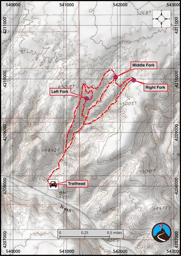
Waypoints:
Trailhead 12S 540747mE 4208028mN
N38° 01' 09" W110° 32' 09"
Middle Fork 12S 541913mE 4210035mN
N38° 02' 13" W110° 31' 21"
Right Fork 12S 542254mE 4209976mN
N38° 02' 11" W110° 31' 07"
Left Fork 12S 541373mE 4209637mN
N38° 02' 01" W110° 31' 43"
Hype
The Leprechaun Canyons are many people's first canyons. Easy access, and relatively straight forward, they
are a good choice. Even a few scenes from the movie 127 Hours were filmed here, just below the confluence
of the middle and right forks, in a stunning cathedral type section. This is one not to miss, and one of my
favorites in the area. Choose your fork wisely if you are a beginner, the middle fork is tight and harder than the
left or right.
Note, those that are not technical canyoneers can still enjoy the canyon from the bottom. The hike up,
staying in the bottom, visits some astounding narrow and slot sections. I've done the technical sections
a few times each, but have probably walked up from the bottom a couple of dozen times with non-
technical groups. It is astounding. One small falls, when coming up from the bottom, is class 4 to
circumvent, but it is otherwise easy going to the junction of the right and middle forks. A great leg
stretcher if passing through the area.
Leprechaun Canyon - North Wash - Road Trip Ryan, LLC - Copyright 2006-2020 1/4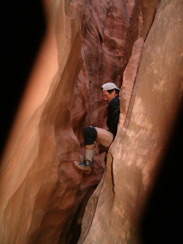
WARNING: Middle fork is VERY narrow! This is not a good place for claustrophobes, or large boned
    canyoneers. Canyoneers that are larger than myself (6'2" / 170 lbs) may have to go high over several
    tight spots, increasing the difficulty. You have been warned! Although you can generally go high, it
    often is difficult to get above constrictions, and the rock is very crumbly and unpredictable.

Tags: canyon, narrow, beginner, intermediate, access: paved

Trailhead
From Hanksville, head south on Highway 95 towards Hite. About milepost 28.1, just after a culvert, is a spur
road on the left going a short distance and ending next to a sandstone wall. This is the trail head.

Route
I recommend doing the three forks in the following order: right, left, then middle. Right is very straight forward
and a good introduction, left has a bit of tricky anchor work, and middle is the most difficult.

Approach (Hikers)
If just hiking up the bottom without doing any of the technical canyon forks, simply follow the social trail up the
bottom of the canyon. As slickrock walls begin to close in, a small narrow slot section can be upclimbed
directly (a little tricky) or bypassed on either left or right with some teamwork.

Once up the minor obstacle, the canyon deepens and narrows dramatically. Just beyond where the Right Fork
comes in, the canyon narrows tight enough most will have to turn sideways to fit. This is the turn around for
most hikers, though some continue up with increasingly difficult obstacles.

Approach (All forks)
From the trailhead, hike up the canyon until a major side canyon comes in on the left (LUC). This is about 20
or so minutes from the trailhead, and not long after a mini-narrows. Hike up the rib between the side canyon
and main canyon to reach the rim. If you use good route finding, nothing is over 4th class. Once on the rim,
follow an emerging trail around to the head of the three forks. Orientate yourself carefully, this is complex
terrain to navigate, and you want to make sure you are dropping into the fork you are expecting. The left fork,
in particular, is relatively small and easy to overlook. Follow the rim around to the fork you wish to descend.

    Note: The topography of the area is a bit complex. Pay very close attention to the map, and double
    check that you are dropping into the correct fork. More than one group has dropped into the wrong fork.

Right Fork

    Note: The right fork tends to hold a fair bit of water after recent rains. During these times, a 40 m ( 132
    ft. ) rope may be useful for alternate rappels around some pools, but you will likely get wet either way!

                         Leprechaun Canyon - North Wash - Road Trip Ryan, LLC - Copyright 2006-2020                  2/4
As soon as you descend off the dirt to the slickrock layer, you will come to a 15 m ( 50 ft. ) drop. Rappel this
off a natural anchor. From here down, you will find several short drops that can be negotiated with partner
assists, or short rappels. The canyon will open and close several times, with a couple of sections that may
require climbing up and over a few feet to descend. None of the climbing is difficult if you look around for the
best route. As you near the confluence with the main fork, you see the varnished wall of the main fork as you
reach the final obstacle, a 10 m ( 33 ft. ) rappel. Inspect this anchor carefully. Once down, you may want to
hike up the middle fork a ways. It is deep, dark, and beautiful. When finished, simply hike down canyon to the
trailhead. The section just below the right and middle confluence is very nice, and photogenic in afternoon
light.
Left Fork
From the rim, contour down slick rock to the head of the left fork. Many options will work, but generally stay to
the left. The fork starts with an 8 m ( 27 ft. ) drop with no obvious anchor. The anchor of choice is a wedged
rock in a pothole back from the edge. Inspect this anchor carefully (which can be hard to do if the pothole is
full). After this rappel, the canyon gets deeper and very interesting. Several drops in this section can be
downclimbed, or rappelled off natural anchors. This fork is quite short, and you will reach the junction with the
middle fork in no time. From the junction, head down canyon through an amazing deep, dark section of slot.
You will have to climb over and under boulders in this section. It is narrow! A headlamp can be a good idea.
Once you reach the junction with the right fork, the canyon opens a bit, and it is an easy walk back to your car.
Middle Fork
Middle fork actually starts with 2 small forks at the top. You want the left fork (looking down canyon). A
downclimb or two will lead you to the first drop, a 6 m ( 20 ft. ) low angle rappel. Once down this drop, you
may choose to take off your harness. The rest of the canyon is narrow, and tends to wear out gear. Head
down canyon, squeezing, climbing and enjoying as you go. About 1/2 way through, you will reach a 4 m ( 14
ft. ) drop into a (sometimes) pool. Use a natural anchor here to rappel. This is the final rappel in the canyon.
Just when you don't think it can get any narrower, it does! After the rappel is where (for me), the crux narrows
lies. It involves a short section I have to stem over, then squeeze through. Shortly after this, the canyon begins
to widen a bit. Right after a downclimb around a pothole the left fork joins up. Breath a sigh of relief, the rest of
the canyon is straightforward and wide in comparison.
Leprechaun Canyon - North Wash - Road Trip Ryan, LLC - Copyright 2006-2020 3/4Leprechaun Canyon - North Wash - Road Trip Ryan, LLC - Copyright 2006-2020 4/4
You can also read