D3.2 FRAMEWORK PROVIDING DEFINITIONS, REVIEW AND OPERATIONAL TYPOLOGY OF RURAL AREAS IN EUROPE - 31 MARCH 2020
←
→
Page content transcription
If your browser does not render page correctly, please read the page content below
D3.2 FRAMEWORK PROVIDING
                               DEFINITIONS, REVIEW AND
                                     OPERATIONAL TYPOLOGY OF
                                              RURAL AREAS IN             EUROPE

                                                                      31 MARCH 2020

SHERPA receives funding from the European Union’s Horizon 2020
research and innovation programme under grant agreement No. 862448.
D3.2 FRAMEWORK             PROVIDING DEFINITIONS, REVIEW AND OPERATIONAL
TYPOLOGY OF RURAL AREAS IN                 EUROPE

 Project name                     SHERPA: Sustainable Hub to Engage into Rural Policies with
                                  Actors

 Project ID                       862448

 H2020 Type of funding            CSA Coordination and Support Action
 scheme

 H2020 Call ID & Topic            RUR-01-2018-2019–D / Rural society-science-policy hub

 Website                          www.rural-interfaces.eu

 Document Type                    Deliverable / Working document

 File Name                        Framework providing definitions, operational typology and review of EU
                                  strategies for rural areas

 Status                           Final

 Dissemination level              Public

 Authors                          Samuel Féret (CIHEAM-IAMM), Tristan Berchoux (CIHEAM-IAMM), Mélanie
                                  Requier (CIHEAM-IAMM), Tahani Abdelhakim (CIHEAM-IAMM). With the
                                  contributions from Elin Slätmo (NordRegio), Olivier Chartier (Ecorys),
                                  Enrique Nieto (AEIDL) and David Miller (James Hutton Institute).

 Work Package Leader              CIHEAM-IAMM

 Project Coordinator              ECORYS

Disclaimer: The content of this document does not reflect the official opinion of the European Union.
Responsibility for the information and views expressed therein lies entirely with the author(s).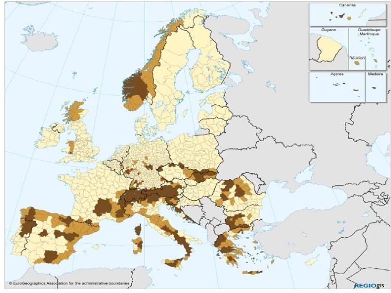
Table of contents
Executive Summary ............................................................................................................... 3

Introduction .......................................................................................................................... 1

1.     From rurality to rural areas ............................................................................................. 2

     1.1. The challenge of defining rural and rurality ............................................................................... 2

     1.2. Contrasting changes and constructs of rurality .......................................................................... 2
                  1.2.1.      Administrative approach ..................................................................................... 3
                  1.2.2.      Morphological approach...................................................................................... 3

                  1.2.3.      Locational approach ........................................................................................... 4

                  1.2.4.      Economic approach ............................................................................................ 4

                  1.2.5.      Landscape approach .......................................................................................... 4
                  1.2.6.      Combined approach ........................................................................................... 5
     1.3. Which ‘new’ rurality? Which rural development? ........................................................................ 5

2.     Typologies of rural area in the EU ................................................................................... 6
     2.1. The OECD typologies............................................................................................................... 6
                  2.1.1.      The 1994 typology ............................................................................................. 7
                  2.1.2.      The 2011 typology ............................................................................................. 7

                  2.1.3.      The 2018 typology ............................................................................................. 8

     2.2. The ESPON typology ............................................................................................................... 9
     2.3. EUROSTAT typologies ............................................................................................................. 9
                  2.3.1.      The urban-rural typology ...................................................................................10

                  2.3.2.      Coastal regions .................................................................................................12
                  2.3.3.      Mountain regions ..............................................................................................12

                  2.3.4.      Disadvantaged areas, areas with a natural constraint and marginalised rural areas 13
                  2.3.5.      Other typologies of rural areas ...........................................................................14

3.     Review of EU main strategies dealing with the rural areas ............................................ 16
     3.1. Main milestones paving the way of EU policies for rural areas ...................................................16
                  3.1.1.      The Future of Rural Society Communication (1988) .............................................17

                  3.1.2.      The Cork declaration (1996) ..............................................................................18

                  3.1.3.      The New Rural Paradigm (OECD, 2006) ..............................................................19

                  3.1.4.      The Cork 2.0 Declaration (2016) ........................................................................19
                  3.1.5.      The Rural Policy 3.0 (OECD, 2018) .....................................................................20
     3.2. Main EU policies on rural: Cohesion and Regional policies, and the CAP .....................................21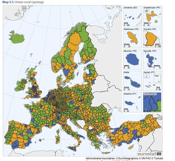
D3.2 | Framework providing definitions, review and operational typology of rural areas in Europe

                  3.2.1.      The Regional Development policy .......................................................................22

                  3.2.2.      The Cohesion policy ..........................................................................................23

                  3.2.3.      The Common Agricultural Policy .........................................................................23

     3.3. The main EU multiannual strategies ........................................................................................24

                  3.3.1.      The Lisbon Strategy ..........................................................................................25
                  3.3.2.      The Europe 2020 Strategy .................................................................................30
                  3.3.3.      ‘A Union that strives for more’ strategy ...............................................................40

4.     Discussion on rural definition, typologies and EU strategies .......................................... 42
     4.1. From an agricultural legacy to a diversified economy: from rural society to rural areas ................42

     4.2. An EU policy framework for rural areas still driven by agriculture ...............................................44

     4.3. From definitions and typologies towards a vision for rural areas ................................................46

5.     Conclusion .................................................................................................................... 49

6.     References ................................................................................................................... 50

7.     Appendixes ................................................................................................................... 59

     Appendix 1: Reallocation of NUTs regions to more urban and to more rural .......................................59
     Appendix 2: Change in percentage rural area between 2000 and 2010 by region ...............................60
     Appendix 3: Remoteness criteria in the OECD typology ....................................................................61

     Appendix 4: Distribution of total population by region, OECD countries..............................................62
     Appendix 5: Share of Gross Value Added and employment in primary activities: predominantly rural
     regions, OECD countries ................................................................................................................63
     Appendix 6: Eurostat typologies .....................................................................................................64
     Appendix 7: Structural types in intermediate and predominantly rural NUTs3 regions .........................66

     Appendix 8: Performance types in intermediate and predominantly rural NUTs3 regions .....................67

     Appendix 9: Changes in Cohesion policy between 1994 and 2020 ....................................................68
     Appendix 10: Green infrastructures: EU policies and instruments ......................................................69
     Appendix 11: Peripherurality indicator’ variables ..............................................................................72

                                                                      Page | 2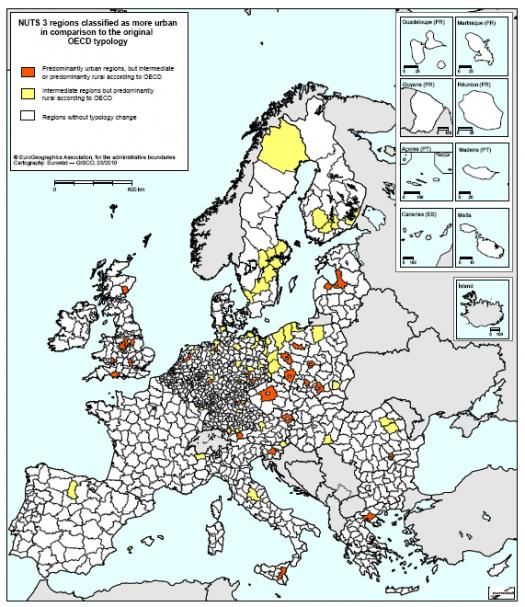
D3.2 | Framework providing definitions, review and operational typology of rural areas in Europe

Executive Summary

This deliverable D3.2 aims at compiling the existing data, knowledge and policy framework on rural in the
EU, so to provide an operational framework for SHERPA multi-actor platforms (MAPs) when they come at
describing rural trends, challenges and opportunities in their respective areas.

The definition of rural and rurality is a longstanding issue which has been the subject of debates in the
scientific literature for a while. While endeavouring to define ‘rurality’, attempts have been made -and still
continue- to understand rurality, leading to various typologies of areas based on different quantifiable criteria.
In that respect, demography, employment, and accessibility are used as main criteria in statistical categories,
which are then used to map the boundaries of the EU rural.
To date, rural was not properly defined through its own characteristics, features and patterns, but was rather
defined as the opposite of urban. To a certain extent, the definition of urban areas can be considered as the
positive print gotten from the photo negative of rural areas. The conceptualisation of functional junction’s
interfaces between urban and rural (i.e. peri-urban, urban influence) contribute to think of territories as a
rural-urban continuum.
From the 80’s to the end of the 90’s, the analytical lens to rural phenomena has changed in Western
countries. The lens evolved from an approach of rural as ‘society’ to ‘areas’, reflecting major driving changes
such as agricultural modernisation, the decline of the farming population, the demographic erosion in rural
areas and the diversification of rural economy.

More than definitions, typologies (and related criteria) of the rural reflect a need for specific and
complementary policy interventions, such as the territorial cohesion, the agricultural or the environmental
policies of the European Union (EU).
Our literature review on institutional and related policy developments has identified specific EU and OECD
documents and declarations which have had a significant impact on the ‘policy fabric’ of rural areas as a
category for public policies. This exercise revealed a twofold longstanding conversation on past and future
rural policies.
The first point lies in the historical roots of the EU integration, with the recognition of the cohesion policy’s
role to flank the agricultural policy -and the structural changes of agriculture- in order to reflect the
demographic and socio-economic changes and trends in rural areas. The support to rural society (in the 80s)
and to rural areas (today), brings back to the essence of the cohesion policy to reduce regional inequalities
in rural areas -including in the less favoured, remote, and marginal areas- across the Community before 1992
and in the EU after this date.
The second point is linked to the nature of policy interventions towards rural areas. Despite successive
influential declaration and reports for a broader rural scope and for an emphasis on the well-being of rural,
the EU rural development policy has remained mainly agriculturally-driven (agri-centric influence) and to a
less extent environmental-driven later on through enhanced agricultural practices.

From this review conducted on EU thematic sub-strategies, our report points out three types of EU strategies
dealing with rural areas since 2000:
    i.       Natural resources-oriented strategies are the most numerous among our review. Biodiversity,
             forests, green infrastructures, adaptation to climate change and soils have a scope on natural
             resources management and on land use in rural areas. Rural areas as physical spaces are
             considered as a geographical support for policy intervention focused on environment and natural
             resources.

                                              Page | 3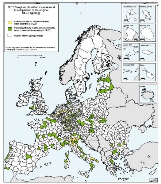
D3.2 | Framework providing definitions, review and operational typology of rural areas in Europe

    ii.      Socio-economic strategies are less numerous under our review (employment, bioeconomy and
             digital strategies). These strategies scoped some of the trends and challenges facing rural areas:
             depopulation, unemployment, diversification of the rural economy, new rural jobs, remoteness,
             digital gap due to poor internet broadband, bio-economy opportunities, etc.

    iii.     Geographic strategies are few under this review. Remoteness and long commuting distances
             shape the way how rural areas are experienced. This is the particularly the case in mountainous
             areas where accessibility to urban centres and employment basins are considered as a physical
             handicap.

The key messages of this review on definitions, typologies and review of EU strategies dealing with rural are:

    1.       Rural policy responses do not mean only those of rural development policy only. Cohesion and
             Regional funds and their synergies should be made more explicit beyond their respective policy
             boundaries.

    2.       Rural development policy does not mean supporting mainly the agricultural sector and farm
             incomes but should, equally focus on rural society more broadly, the rural economy and rural
             environment.
    3.       A EU long-term vision for rural areas should be based upon the overarching objective of well-
             being in rural areas.

                                                      Page | 4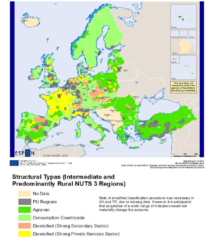
D3.2 | Framework providing definitions, review and operational typology of rural areas in Europe

Introduction

The definition of rural and rurality has been the subject of debate and numerous research papers for almost
60 years. While endeavouring to define ‘rurality’, attempts have also been made to understand rurality in
space, leading to various typologies of areas based on different quantifiable criteria. This reflects a necessity
for politicians and decision-makers, initially within the framework of land management policies and, second,
within the context of public policies (agricultural and rural development policies, cohesion policy of the
European Union).

The changing typologies reflect both the desire to monitor and to understand economic and demographic
developments in rural areas as well as the social demand and citizens’ perceptions of what rurality represents.
However, typologies on urban and rural areas do also reflect on institutional arrangements and policy
frameworks for spatial planning and areas development.

In this report, the references used in this report are primarily research works and documents relating to EU
policies. It should be noted that the vast majority of the research works consulted on rural and rurality date
from the period between the 1980s and the mid-1990s. From the 90s onwards, the number of scientific
works on the “notion of rural and rurality” diminished and began to focus primarily on types of rural area
rather than the ‘definition’ of rurality itself.
This report is divided into four sections. The first is a summary of the research works and debates relating
to the definition of rurality and the criteria adopted. The second part presents the main typologies of rural
area used at EU level. The third section reviews the main EU strategies dealing with rural, including the main
milestones set by the EU and the OECD, the main EU policies on this, the pluriannual strategies of the EU
and its sub-thematic strategies. This last section concludes with a discussion on the meaning of any EU policy
framework for the rural and explore avenues for further developments.

                                              Page | 1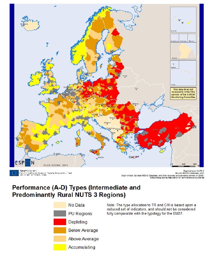
D3.2 | Framework providing definitions, review and operational typology of rural areas in Europe

1.     From rurality to rural areas

     1.1.         The challenge of defining rural and rurality

Across the range of definitions, approaches and scientific positions on the subject of rurality, there is a
consensus on the following two points. First, rurality appears to be an obvious notion which has persisted
but which is difficult to define. Second, defining ‘rurality’ depends on: i) global contexts (i.e. the
characteristics of the socio-economic systems of which the rurality is a part); ii) the discourse and political
objectives pursued; and iii) the social representations of the different categories of stakeholders. In Europe,
each country has developed its own definition of rurality, often as a response to a very specific political,
administrative and social context, and in some cases as an output of regional classifications of other factors
(e.g. population, accessibility). Approaches and definitions are rarely similar between countries (Depraz,
2007; Bontron, 1996). As a consequence, there is no European-wide or international definition of ‘rurality’
(European Commission, 2012).

Rurality was initially analysed by sociologists and geographers, with the focus from economists coming later.
In the 1970s, in light of the difficulty to define ‘rurality’ at a national level and the impossibility of defining it
at a European level, researchers tried to define ‘rurality’ through the identification of the characteristics of
rural areas. Early work by sociologists and geographers tackled rurality through factors such as lifestyle,
value systems and the relationship to earth and family. Thus, rurality was defined by three elements: the
dominance of pastoral activities, specifics of value systems (role of the family, land ownership, tradition, etc.)
and specifics of lifestyles (self-consumption, work, village solidarity, etc.) (Bontron, 1996). The rationale
behind this definition is that such specificities lead to an extensive use of the land, thus resulting in habitat
dispersion and a low population density.

Drawing on the identity of farming culture, this first definition was not operationalised for designing and
implementing land management policies. It was quickly outdated due to the transformations taking place in
the rural socio-economic environments. Research reported on the characteristics of rurality in a given area,
from a spatial perspective, which had two consequences. First, it led researchers to characterise rurality as
a social construct (Brunio, 2008) and that the identity of space depends on the actor who perceives it and
what it means to them (Bodiguel, 1985). The meaning of rurality also depends upon the context (Van Eupen,
2012) and the criteria adopted in its definition (Chevalier et al., 2010). Second, it highlighted a wide variety
of the characteristics of rural areas.

Rural areas have undergone profound economic and social changes since the first implementation of
agricultural policies aimed at modernisation and land management in the 1960s. As a consequence, rurality
can no longer be defined solely according to agricultural activities and associated lifestyles. Although there
is no consensus in the literature about the determinants of rural changes, two different drivers can be
highlighted (Chevalier, 2010; Bruno, 2008): i) an economic, social and environmental decline except in zones
benefitting from urban extension and land use intensification; and ii) a revival of rural areas due to their
endogenous dynamics. These two visions reflect the co-existence of realities, and the diversity of rural areas
and their trajectories.

     1.2.         Contrasting changes and constructs of rurality

For most European countries, since the 1990s, the analysis of demographic and economic data relating to
rural areas shows a decline of agriculture in both economic and demographic terms (Plieninger et al., 2016).
The role of agriculture as an economic activity is in sharp decline in terms of GDP and employment, with
rural areas being abandoned in terms of people and services. Over this period there has been a decrease in
the proportion of farmers in the rural population, which is itself ageing and steadily falling as a proportion of
the total population.

                                                         Page | 2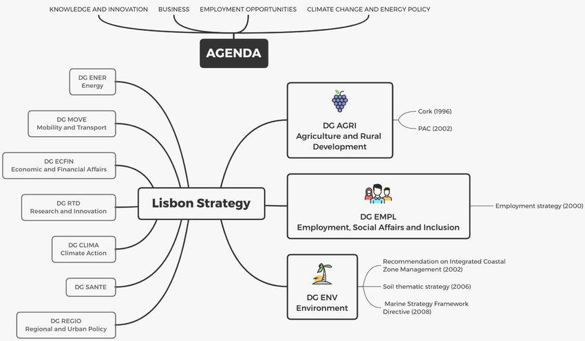
D3.2 | Framework providing definitions, review and operational typology of rural areas in Europe

These characteristics indicate a process of decline. From the mid-1990s, other elements point to an inversion
of the situation, referred to as “rural renaissance” in the literature: i) the economy of rural areas is becoming
more diverse, witnessing strong growth in the tertiary sector (services and tourism); and ii) population
growth due to the arrival of new inhabitants, in particular young people.

Several approaches have been adopted to identify new characteristics for rural areas, how these areas are
sub-divided. and how they are classified. Rurality has been defined dichotomously as a contrast to urbanity,
or as the negative of urbanity (i.e. anything that is not urban is rural) (Depraz, 2007). Initially, the distinction
between urban and rural areas was based on a single criterion (e.g. population density, presence of
agriculture). However, approaches combining several criteria have been adopted, as rural areas were
recognised as complex and unable to be characterised by using a single criterion (Van Eupen, 2012). Criteria
used to identify and categorise rural areas illustrate how they are perceived and public policy objectives.
Six types of approaches can be identified in the literature: i) the administrative (or statutory) approach,
based on legal-administrative character; ii) the morphological (or demographic) approach, based on
population criteria such as population density; iii) the locational approach, based on spatial relationships
between urban and rural areas; iv) the economic (or structural, and functional) approach, based on criteria
such as the share of agricultural GDP or the cost of services; v) the landscape approach, based on land-
cover and climatic conditions; and vi) the combined approach, which used a combination of at least two of
the other approaches.

1.2.1.    Administrative approach

The administrative (or statutory) approach has been used mainly in the countries of Eastern Europe (Depraz,
2007). For example, in Poland, rural areas are defined as areas outside of the administrative boundaries of
towns (Bański, 2006; Dymitrow, 2013). According to Bański and Mazur (2016), such an approach has limits,
for example, areas neighbouring large urban agglomerations, which display more urban than rural features
in functional, landscape and structural terms, will be classified as non-urban. In contrast, small towns might
have strong functional relations with the neighbouring rural areas and display rural features (e.g. low density
of population, low building density, high share of population employed in agriculture, high share of
agricultural or forest land), which could qualify them as rural areas.

1.2.2.    Morphological approach

The morphological approach has changed from the use of a single criterion to a combination of several
criteria. The two criteria commonly used (depending on the country) are population size and population
density. In France, for example, the INSEE (national statistical institute) uses population size to classify
municipalities either as urban (with an urban area of more than 2,000 inhabitants) or as rural (without an
urban area of more than 2,000 inhabitants). The threshold adopted varies from one country to another: for
example, 5,000 inhabitants in Belgium and 10,000 inhabitants in Spain (Chevalier, 2008).

Other European countries such as Portugal, The Netherlands and some Scandinavian countries use the
criterion of population density (Depraz, 2007). This criterion appears pertinent to avoid the distortions
resulting from the different sizes in different countries. The OECD adopted the threshold of 150
habitants/km² to define three types of region according to population density (Serrano, 2014): i) urban
region with more than 85% of the population living in municipalities of more than 150 inhabitants/km²; ii)
semi-rural regions with between 50% and 85% of the population living in municipalities of more than 150
inhabitants/km²; iii) rural regions with less than 50% of the population living in municipalities of more than
150 inhabitants/km².
According to Serrano (2014), the morphological approach is mostly used at national institutional levels in the
EU, either alone or combined with other approaches. Deemed statistically robust, it nevertheless raises the
question of the thresholds used by each country (Depraz, 2009).

                                               Page | 3
D3.2 | Framework providing definitions, review and operational typology of rural areas in Europe

1.2.3.    Locational approach

The locational approach expresses definitions of rural areas in relation to urban areas or subjected to urban
influence (Bański and Mazur, 2016). The main criteria refer to accessibility measures, such as the distance
to urban centres or the daily commute of the population to their place of work. Distance to towns is also
used as an indicator to characterise rural populations’ access to a wide range of services and opportunities
(Dijkastra, 2008). The categories of rural areas defined using a combination of these criteria essentially
reflect the level of integration or isolation of rural areas in relation to urban areas.

1.2.4.    Economic approach

The economic approach defines rurality according to the type of economic activity (specialised or diversified
agricultural activities), and in particular according to the level of clustering or dispersion of these activities.
The term ‘urban’ was first used to indicate the separation of the land as a source of income (Bibby, 2004).
The characterisation of rural areas according to the economic approach is based either on criteria such as
the share of the primary sector in GDP, average per capita income and service costs (healthcare and
education), or on the application of a theoretical model inspired by spatial or territorial economics. The
analysis conducted by Blanc (1997) illustrates how the construct of rurality depends on the model used. They
identified three approaches: i) the spatial approach; ii) the functional or territorial approach; and iii) the
constructivist approach.

The spatial approach (inspired by spatial economics) considers the location of economic operators in light of
the availability of resources, distances and transport costs. This leads to a clustering of activities and services
in order to achieve economies of scale while activities which do little to promote concentration will become
scattered. This process will create a tiered area with centres and peripheries, depending on the level of
concentration. Peripheral activities are not highly intensive and make use of natural resources while the
labour force is relatively unskilled and undiversified. This approach defines rural areas as those excluded
from the clustering process, and thus as peripheral areas.

The functional (or territorial) approach is based on the relationships between economic agents and proximity
as factors conducive to economic performance and the upgrading of resources. In this approach, rural areas
provide both specific resources and a potential for endogenous dynamics. The functional approach is common
at transnational (EU and OECD) institutional level. Rural areas defined as a “regional interactional concept
closely linked to urban areas” is the pivotal concept in the EU’s regional policy. It is also the approach used
in the typologies of the OECD, ESPON and EUROSTAT. For example, the typology developed by the French
INSEE in 1999 and modified in 2010 is based on the number of jobs and the ‘attraction’ of the population
living in rural municipalities to jobs in urban centres. The 2010 INSEE typology, called ‘zoning in urban areas’,
defines rural municipalities as units where 40% of the resident population works in an urban hub: i) large
urban areas, characterised by an urban hub with more than 10 000 jobs; ii) medium areas, defined as an
urban hub with between 5 000 and 10 000 jobs; and iii) small areas, characterised by an urban hub with
between 1 500 and 5 000 jobs (INSEE, 2010). This approach does not characterise rural areas but instead
defines rural as being based on the area of influence of cities.
The constructivist approach is based on the representations of the groups of actors. Rurality will take on
different meanings for farmers, who consider area as a working environment and resource, and for other
residents to whom it represents landscape and a contribution to their quality of life.

1.2.5.    Landscape approach

In recent studies, greater attention is paid to environmental aspects in the perception of rural areas and
regarding the social demand for them (Bański and Mazur, 2016). This has led researchers to design new
approaches to define rural. In particular, landscape and socio-ecological approaches have emerged in the

                                                        Page | 4
D3.2 | Framework providing definitions, review and operational typology of rural areas in Europe
field of environmental geography, using land-cover data and climatic conditions to distinguish typical
landscapes (Van Eupen, 2012). For example, criteria include building density, level of urbanisation, continuity
of the built-up area and share of forest. Such criteria have sometimes been used within morphological
approaches to enhance the definition of rural areas (Serrano, 2014; Bontron, 2015). For example, in the
Netherlands, rural areas are defined according to different landscape criteria, the main one being building
density within a 1 km radius (Serrano, 2014).
1.2.6. Combined approach
The combined approach usually links the criteria used in the approaches described above: locational and
structural approaches (e.g. Rosner, 2008; Prieto-Lara and Ocaña-Riola, 2010; Copus, 2013), locational and
landscape approach (Dijkstra and Ruiz, 2010; Berchoux et al., 2019). Some countries also use such
approaches. For example, in Sweden, urban areas (tätort) are defined based on both landscape and
morphological features, requiring contiguous buildings with no more than 200 metres between houses, and
at least 200 residents, to be considered urban.
In the EU SIMRA project, combinations of criteria were used to define marginalised rural areas (Price et al.,
2017). The characteristics used includes changes in classification of rural, and of the proportion of rural due
to changes in population (see in Appendix 1 and 2).
1.3. Which ‘new’ rurality? Which rural development?
While the wide variety of approaches and criteria used to define rurality reflects the difficulty of the task, it
also reflects the existence of profound endogenous changes (demography, diversification of activities, etc.)
and exogenous changes (new social demand, globalisation, etc.), either current or future, prompting a review
of what rurality is and will be. Research studies have highlighted the development of the tertiary sector in
rural areas. This is the result of demographic change due to the influx of new residents (retirees and/or
young people) and the development of tourism. The tertiary sector and tourism underpin the diversification
of economic activities in many rural areas (varying in degree from one region to another). This dual trend
represents a new vision of rural areas as a location providing services, leisure activities and a certain quality
of life.
Public policies have gradually incorporated a phenomenon that researchers refer to as the ‘de-
agriculturalization’ of rural areas (Perrier-Cornet, 2002), meaning a dissociation of the agricultural from the
rural. The adoption of the concept of multifunctionality and its dissemination across a broad sphere (academic
and professional) has contributed to this process of ‘de-agriculturalization’ (Brandt, 2003; Woods, 2011).
Within the concept of multifunctionality, three functions of rural areas can be identified: the productive
function, the residential and recreational function, and the environmental function. These functions refer to
the different uses of rural areas, which include: as a ‘resource’, referring to the productive function; as a
‘living environment’, referring to the residential and recreational function; and as ‘nature’, referring to the
environmental function. Land considered as ‘nature’ corresponds to a definition of nature as a ‘factory’, a
source of resources (water, soil, biodiversity, climate, prevention of natural risks, etc.), which must be
protected and conserved (Perrier-Cornet, 2002). This function represents a vision of rural areas as producers
of amenities and public goods.
The multi-functionality of rural areas is also reflected through the ecosystem services paradigm in which
functions include regulating and cultural services as well as those of provisioning and supporting.
Parallel to the rise of the multifunctionality concept in the 90’s, a new rural development paradigm emerged
in both policy, practice and theory dimensions. Rural development appears there as a disputed and
controversial concept or a heuristic device (Van der Ploeg et al., 2001). These authors suggested that rural
development came out timely after the crisis of the agricultural modernisation paradigm in Europe as a way
Page | 5D3.2 | Framework providing definitions, review and operational typology of rural areas in Europe
to figure out and to envision future perspectives for rural populations and rural areas. Diversification of the
rural economy, new forms of rural entrepreneurship, pluri-activity, low-inputs farming systems, regional food
supply chains, quality products strategies, multi-level rural governance and Leader approaches for instance,
express the various trends that arise as new opportunities for making rural areas more attractive.
2. Typologies of rural area in the EU
Most European policies do not have a clear definition of rurality, yet planning authorities use typologies in
their identification of areas in strategic planning and implementation of spatial policy. This section gives an
overview of the main typologies used for the implementation of European policies and discusses the vision
of rural they convey.
Constructing a typology of rural areas is not a neutral exercise. It involves dissecting and classifying areas
into several homogeneous categories according to one or more criteria, ultimately producing entities which
did not pre-exist. The entities created meet certain needs including: i) administrative needs to organise
population management at the local level; ii) political needs to organise the types of power within the national
space; and iii) organisational needs in terms of the collection of information which is essential for decision-
making purposes (Chevalier, 2010). Constructing a typology means making trade-offs and choices. The latter
are made according to the needs and problems for which the typology is constructed and are theoretical and
methodological in nature.
In methodological terms, there are three elements used for constructing a typology: the criteria, the
thresholds adopted and the spatial scale. The choice of criteria depends on the purpose and need of the
typology. Thresholds (in terms of population size or surface area for example) will depend on settlement
patterns and total area of each country, such as described in Section 1.2.2. The results obtained by applying
the same criterion will differ considerably according to the thresholds used. The spatial scale varies according
to the objective sought.
In general, two different levels will be used in SHERPA to analyse and classify rural areas at the national
level: i) to define homogenous rural areas, the smallest appropriate territorial unit will be used, i.e. the local
community (municipality); and ii) to analyse functional relationships, regional-level units will be used (OECD,
1994).
The spatial scale used for the typology depends on data availability. Typologies increasingly tend to adopt
the scalar nesting method, such as in the INSEE or OECD typologies. This method involves creating a
classification in two phases and using two spatial scales (DEPRAZ, 2009). First, there is a classification of the
smallest local units according to a single criterion. These categories are then reclassified into new categories
on a broader, regional scale. This results in categories such as ‘essentially rural regions’, ‘relatively rural
regions’, ‘essentially urban regions’ that can be found in the OECD typology.
In theoretical terms, the typologies presented hereinafter adopt the same theoretical choices, which are the
level of clustering or dispersion of the population and activities, and the rural-urban relationship.
2.1. The OECD typologies
The first OECD typology, published in 1994, was based on the criterion of population density (morphological
approach). The two updates of the typology in 2009 and 2018 referred to the paradigm of the rural-urban
relationship described above. This theoretical choice led to concepts and methods being developed and
implemented when constructing the two typologies, in particular: i) the introduction of an indicator of
remoteness from urban centres as a means of categorising areas; and ii) the construction of the concept of
the functional urban area.
Page | 6D3.2 | Framework providing definitions, review and operational typology of rural areas in Europe
2.1.1. The 1994 typology
In 1994, the OECD proposed a typology of rural areas1 based on the principle of scalar nesting, primarily
using on two criteria: population density at local level to identify rural municipalities, and the percentage of
the population of rural municipalities at regional level. The categories in this typology were as follows for
Europe (OECD, 1994): at the local level with rural municipalities with a population density of less than 150
inhabitants/km² and urban municipalities for over 150 inhabitants/km². At the regional level, the typology
identified three classes: i) predominantly rural regions with more than 50% of the regional population living
in rural municipalities; ii) relatively rural or intermediate regions with 15% to 50% of the regional population
living in rural municipalities; and iii) predominantly urban regions with less than 15% of the regional
population living in rural municipalities. The presence and size of urban centres modified the classification of
regions. If a region classified as essentially rural included an urban centre with more than 200 000 inhabitants
accounting for at least 25% of the regional population, it was categorised as an intermediate region. If an
intermediate region included an urban centre with more than 500 000 inhabitants accounting for at least
25% of the regional population, it was categorised as predominantly urban.
In summary, this typology quantified the degree to which an area is ‘rural’, rejecting the dichotomy between
rural and urban areas.
2.1.2. The 2011 typology
In 2011, the OECD typology was updated to include a model drawn from the work of Dijkastra and Poelman
(2008). It was based on the hypothesis that remoteness of rural areas from urban hubs was a key
determinant of the characteristics of these areas. They compared remote rural areas with those close to the
cities using several variables and indicators including population density, per capita GDP, share in GDP,
productivity, value added, etc., with the results showing considerable differences. For example, in rural areas
outwith urban hubs they characterised such areas as having: an average population density half that in rural
areas close to urban centres; per capita GDP three points lower than per capita GDP in rural areas close to
urban centres; productivity in three sectors (agriculture, industry and services) is ten points lower than in
rural areas close to urban centres; and the share of value added from the agricultural sector is higher but
productivity is lower.
A region is considered close to an urban centre if half the population can reach an urban centre of at least
50,000 inhabitants in less than 45 minutes, and deemed remote if this is the case for less than half the
population (Dijkastra and Poelman, 2008). Remoteness, or accessibility of rural areas, appeared to be directly
linked to what the OECD refers to as a low-density economy, or rural. This results in economic structures
displaying little diversification and unskilled jobs (OECD, 2018), although they can provide other opportunities
for space-demanding activities, such as server farms to support digitalisation. By applying this indicator of
remoteness to the categories defined by the 1994 typology, the new categories were (OECD, 2011): i) urban
or predominantly urban regions; ii) intermediate regions close to an urban centre; iii) remote intermediate
regions; iv) rural or predominantly rural regions close to an urban centre; and v) remote rural or
predominantly rural regions (Figure 1).
1
The typologies of rural areas were applied to the NUTs 3 regions of the EU, i.e. the regions with a
population ranging from a minimum of 150,000 inhabitants to a maximum of 800,000.
Page | 7D3.2 | Framework providing definitions, review and operational typology of rural areas in Europe
Figure SEQ1.Figure
Figure OECD\* ARABIC 2: typology,
urban–rural Extract from Dijkastra
2011, appliedand
to Vicente,
EuropeanOECD,
Union Member States at NUTS 3 level
2010
2.1.3. The 2018 typology
In 2018, the OECD produced a new typology complementing the previous typologies by introducing the
concept of ‘functional urban areas’ (OECD, 2018) to better reflect the link between rural and urban areas
through access to the labour market and public services as well as environmental questions. In this new
typology, a town corresponds to one or more local units where at least 50% of the population live in an
urban centre. A functional urban area (FUA) includes a town and its surroundings consisting of less densely
populated local units which are nevertheless part of the town’s labour market due to commuting, i.e. people
Page | 8D3.2 | Framework providing definitions, review and operational typology of rural areas in Europe
travelling from their place of residence to the labour market and/or to access services (healthcare, education,
culture, shops, etc.) (Dijkastra and Poelman, 2019).
The typology differentiates three types of rural regions. First, rural areas within a functional urban area
(FUA), which are an integral part of the commuting area of the urban centre and their development is fully
integrated into the development of the latter. Second, rural regions close to a functional urban area, which
are not part of the area’s labour market, but flows of products and services still exist. The development of
these rural regions depends on the development of the functional urban area. Third, rural regions far from
a functional urban area, for which personal interactions outside these regions are limited and infrequent.
The local economy depends on product exports from the primary sector.
The agricultural nature of the predominantly rural regions varies according to the share of agriculture in total
employment (ranging from 40.5% in Romania to 3.2% in Belgium) and in value added (13.3% in Latvia and
1.4% in Germany) (OECD, 2018 and Appendix 4, 5, Figures 15-16). Remote predominantly rural regions are
the most economically fragile due to their high level of dependence on primary activities and their low
productivity. They are also most vulnerable to external shocks. Predominantly rural regions would appear to
offer certain advantages concerning the population’s well-being, in particular with regard to the environment.
They are nevertheless at a clear disadvantage with regard to access to services, education, healthcare and
safety.
2.2. The ESPON typology
The EDORA project (European Development Opportunities for Rural Areas) is a project within the ESPON
programme, which resulted in the construction of a typology at the NUTs3 level, covering intermediate and
predominantly rural regions. It is based on the 2011 OECD typology, refining the rural-urban relationship by
taking into account the relationship between rural regions and a network of small and medium-sized urban
centres (Copus and Noguera, 2010). The aim was to classify non-urban regions according to three
dimensions: rurality and accessibility; economic restructuring; and socio-economic performance
(accumulation or decline). The main characteristics resulting from this typology were: i) agricultural regions
(23.2% of all regions) with 87% of its population living in regions in decline or with poor economic
performance; ii) consumption countryside regions (50% of all regions) with 67% of the population living in
regions displaying good economic performance; and iii) diversified regions with a market services sector
(19.6% of all regions) with 66% of the population living in regions displaying good economic performance.
2.3. EUROSTAT typologies
6
For Europe, since 2011, Eurostat has defined ‘rural’ using 1km2 grid cells, with a two-stage process to,
initially, identify the population in urban areas: i) population density threshold (300 inhabitants/km2)
calculated for 1 km2 grid cells; and ii) minimum size threshold (5 000 inhabitants) applied to grouped grid
cells above the density threshold. The EUROSTAT typology adopts numerous methodological elements and
theoretical hypotheses of the OECD work as they were conducted jointly.
To harmonise the collection and analysis of the statistics, EUROSTAT uses a three-level nomenclature of
territorial units (NUTs):
• NUTs 1: regions with between 3 000 000 and 7 000 000 inhabitants;
• NUTs 2: regions with between 800 000 and 3 000 000 inhabitants;
• NUTs 3: regions with between 150 000 and 800 000 inhabitants.
• NUTS 3 regions are based on existing administrative entities. National governments can ask for the
NUTS system to be revised to reflect changes at a national level (Eurostat, 2013), and three regular
Page | 9D3.2 | Framework providing definitions, review and operational typology of rural areas in Europe
amendments were introduced between 2007 and 2015, as well as an extraordinary amendment
which came into force in 2015 (http://ec.europa.eu/eurostat/web/nuts/history). Changes between
2013 and 2015 affected 185 NUTS 3 regions. Some such changes relate to recoding, and others
include boundary changes or shifts (e.g. Poland, Netherlands, Germany, Finland and the UK), and
new regions introduced, discontinued, split or merged (e.g. Poland, Germany, Ireland, France,
Hungary). Such changes have led to an evolving record and representation of the socio-economic
characteristics of the European area. The changes can be small with respect to their impact on the
division of European space into rural and urban, but have implications for consistency of data and
use.
• The EUROSTAT territorial typologies are summarised in Figure 2, extracted from the methodological
manual of territorial typologies (EUROSTAT, 2018).
Figure 2. Territorial typologies, extracted from the methodological manual of territorial typologies (EUROSTAT,
2018).
These typologies are based on the following elements:
• the population grid comprising cells of 1 km² (presented above);
• the functional urban areas (FUA) and their commuting zones;
• the local administrative units (LUAs) which generally correspond to the municipalities, are used to
define the local typologies such as the functional urban areas and commuting zones;
• an urban cluster consists of a cluster of contiguous grid cells of 1 km2 with a population density of
at least 300 inhabitants per km² and a minimum population of 5,000 inhabitants.
https://ec.europa.eu/eurostat/statistics-explained/index.php?title=Glossary:Urban_cluster;
• rural areas are areas located outside the population grid cells identified as urban centres or urban
clusters.
2.3.1. The urban-rural typology
Page | 10D3.2 | Framework providing definitions, review and operational typology of rural areas in Europe
The ‘urban-rural typology’ (EUROSTAT, 2018) classifies areas (at the level of NUTs3 regions) according to
the level of urbanisation (Figure 3). The classification is:
• predominantly urban regions (over 80% of the population living in an urban cluster);
• intermediate regions (between 50% and 80% of the population living in an urban cluster);
• predominantly rural regions (less than 50% of the population living in the area corresponding to the
part of the population grid not identified as urban centres or urban clusters).
Figure 3. Urban-rural typology for Europe (Eurostat, 2018).
In 2016, the 1 348 NUTs3 regions (28 countries) were designated as follows:
• 367 predominantly urban regions (27%)
• 553 intermediate regions (41%)
• 428 predominantly rural regions (31%)
All three types of region are found in all European countries except for Malta, Luxembourg and Cyprus. Since
2016, three NUTs3 regions classified as predominantly rural have become intermediate regions and three
others classified as intermediate have become predominantly urban. The population in the predominantly
rural regions rarely exceeds 30% of the total population, as shown in Figure 4, from the Eurostat
methodological manual of territorial typologies (2018).
Appendix 1, Figure 12 shows the geographic distribution of the reallocation of NUTS3 regions to more urban,
and more rural, with the introduction of the new classification system. As population, and patterns of
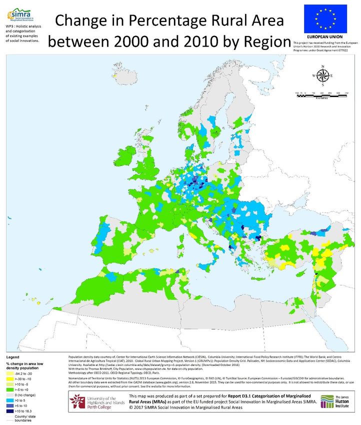
development, change so attribution of a region as rural may change. For example, Appendix 2, Figure 13,
shows a map of the changes in the percentage per squared kilometre (< 150 people per km2; 2010) per
NUTS 3 is shown for Europe and the Mediterranean region (from Price et al., 2017).
A revision to the urban-rural typology has also been tested and introduced by the EU. This simplifies the
typology into two levels (urban and rural), with a threshold of population density of 300 people per km 2, and
Page | 11D3.2 | Framework providing definitions, review and operational typology of rural areas in Europe
a minimum population threshold of 5 000 (Eurostat, 2011; http://ec.europa.eu/eurostat/statistics-
explained/index.php/Urban-rural_typology).
Figure 4. Population structure by urban-rural typology (% share of total population) (Eurostat, 2018).
The theoretical and methodological choices underpinning the ‘urban-rural typology’ are: i) there is no
dichotomy between rural and urban areas, only degrees of urbanisation and rurality; ii) the level of population
and activity clustering or dispersion is a key dimension and a discriminatory factor; and iii) the rural-urban
relationship provides the analysis framework to categorise rural areas.
2.3.2. Coastal regions
According to the EUROSTAT methodological manual of territorial typologies, coastal areas are local
administrative units bordering or close to a coastline. The coastline is the line where land and water surfaces
meet. To harmonise the delineation of this line, the European Commission has adopted the use of the mean
high tide. Coastal areas are defined on two levels: local administrative units (LAUs) and NUTs3 regions.
At the local administrative unit level, two types of area are identified: i) coastal areas, which is defined as
local administrative units that border the coastline or local administrative units that have at least 50% of
their surface area within a distance of 10 km from the coastline; and ii) non-coastal areas, which is defined
as local administrative units that do not border the coastline and have less than 50% of their surface area
within a distance of 10 km from the coastline.
At the NUTs3 level, two types of regions are differentiated: i) regions with a maritime border; and ii) regions
where more than half the population lives less than 50 km from the coastline.
2.3.3. Mountain regions
These are defined according to the following criteria (Eurostat, 2018):
• regions where more than 50% of the surface is covered by a mountainous topography;
• regions where more than 50% of the population live in areas displaying a mountainous topography;
• regions where both the previous conditions are met.
Page | 12D3.2 | Framework providing definitions, review and operational typology of rural areas in Europe
Criteria to delineate mountainous topography are developed using a digital elevation model. Above an
altitude of 2 500 m, all regions are deemed mountainous. Below 2 500 m, the criteria used are altitude, slope
and slope radius. Below and altitude of 300 m, topography is added to the previous criteria (altitude, slope
and slope radius) in order to incorporate specific characteristics of mountain regions in Scotland and Norway
and along the Mediterranean coast.
Using these criteria, 323 of the 1 348 NUTs3 regions are classified as mountain regions (Figure 6), divided
into two categories:
• 170 NUTs3 regions where more than 50% of the population live in mountain areas and more than
50% of the surface is covered by mountain areas;
• 148 NUTs2 regions where more than 50% of the surface is covered by mountain areas.
Figure 5. NUTS3 regions classified by mountainous area (extract from Dijkastra and Poelman, 2011).
2.3.4. Disadvantaged areas, areas with a natural constraint and marginalised
rural areas
Disadvantaged areas and areas with a natural constraint have been subject to debate regarding their
eligibility under the CAP but are not included in the EUROSTAT territorial typologies. According to EU
Regulation 1305/2013, Member States have updated their zoning areas under natural constraints, mainly
taking account of biophysical criteria.
Disadvantaged areas are subject to natural constraints which affect agricultural production conditions
through lower yields and higher costs. Since 1975, to reduce the rate and level of depopulation, maintain
agricultural activity and conserve the environment, EU agricultural policy has awarded aid, referred to as
compensatory allowances for natural handicaps (or CANH), to farmers in disadvantaged areas. These
allowances are divided into three groups (Orshoven et al., 2012):
Page | 13D3.2 | Framework providing definitions, review and operational typology of rural areas in Europe
• mountain areas: where the altitude, low temperatures and steep slopes represent difficult conditions
or handicaps to agricultural production;
• intermediate disadvantaged areas: where the level of soil fertility is low, and the climate poses
challenges to agricultural production, resulting in the level of production being weak. Population
density is low in these areas, with further declines in their population threatened. Nevertheless,
maintaining an extensive agricultural activity is necessary for the purposes of soil management;
• areas with specific handicaps: where it is necessary to maintain agricultural activity despite
handicaps in order to conserve the environment and protect both the landscape and the tourism
potential.
Following criticisms levelled at the compensatory allowances for natural handicaps, either with regard to their
weak impact or their high cost, the EU initiated a reform aimed at redefining disadvantaged areas. Within
the framework of this reform, the demarcation criteria of intermediate disadvantaged areas have been limited
to two biophysical criteria: the soil and the climate.
For the 2014-2020 programming period, the three types of disadvantaged area are:
• mountain areas;
• areas subject to natural constraints (instead of intermediate disadvantaged areas);
• areas subject to specific constraints.
The rural development regulation 2014-2020 stipulates that EU Member States must redefine the areas
subject to natural constraints according to biophysical criteria. Each State defines the areas subject to specific
constraints, up to a limit of 10% of its surface area either by applying specific criteria deemed relevant in
relation to the agricultural and territorial particularities or by combining these specific criteria with the
biophysical criteria.
The aim of the reform of the definition of the areas subject to natural constraints is for those areas to be
defined according to natural constraints which cannot be overcome by means of investment and technology.
Several EU guides and documents present methods and advice concerning the application of the biophysical
criteria and combinations thereof (e.g. Terres, 2014; Terres, 2016), and for what is referred to as ‘fine-
tuning’ purposes.
Initially, this fine-tuning has been implemented with regard to the biophysical constraints. In the case of a
municipality subject to drought, for example, if there has been investment in irrigation, the area benefiting
from this investment could be deducted from the area subject to the constraint (Le Barh et al., 2018).
Across all the territorial units adopted after this initial stage, a second fine-tuning process checked whether
the technical-economic constraints have been overcome. In France, for example, the criteria chosen for this
technical-economic fine-tuning were the standard output/ha, livestock density/ha of forage area, and the
average yield of soft wheat per department (Le Barh et al., 2018).
This reform will lead to several regions being withdrawn from the category of those classified as subject to
natural constraints, while other new areas with natural constraints will be added.
2.3.5. Other typologies of rural areas
PeripheRurality Indicator (PRI)
In an article exploring the links between the degree of rurality in NUTS3 regions and the allocations of the
rural development programmes (RDP), some Italian economists (Camaioni et al., 2013) proposed a new
measurement of rurality. Considering the outdated status of the urban-rural divide on one side, they reframe
a set of indicators used against the RDP allocations. In that respect, they aggregate socio-economic data
with geographical features of NUTS3 regions. Thereby, four major thematic have been scoped: i) socio-
Page | 14You can also read