Territorial cohesion and water management in Europe: the spatial perspective - EEA Technical report No 4/2012
←
→
Page content transcription
If your browser does not render page correctly, please read the page content below
EEA Technical report   No 4/2012

               Territorial cohesion and water
management in Europe: the spatial perspective

                                              ISSN 1725-2237
EEA Technical report   No 4/2012

               Territorial cohesion and water
management in Europe: the spatial perspective
Design: EEA
Layout: Rosendahl-Schultz grafisk/EEA
Cover photo: EEA

Legal notice
The contents of this publication do not necessarily reflect the official opinions of the European Commission
or other institutions of the European Union. Neither the European Environment Agency nor any person or
company acting on behalf of the Agency is responsible for the use that may be made of the information
contained in this report.

Copyright notice
© EEA, Copenhagen, 2012
Reproduction is authorised, provided the source is acknowledged, save where otherwise stated.

Information about the European Union is available on the Internet. It can be accessed through the Europa
server (www.europa.eu).

Luxembourg: Publications Office of the European Union, 2012

ISBN 978-92-9213-317-7
ISSN 1725-2237
doi:10.2800/49764

 REG.NO. DK- 000244

European Environment Agency
Kongens Nytorv 6
1050 Copenhagen K
Denmark
Tel.: +45 33 36 71 00
Fax: +45 33 36 71 99
Web: eea.europa.eu
Enquiries: eea.europa.eu/enquiries
Contents

Contents

Acknowledgements..................................................................................................... 4
Executive summary..................................................................................................... 5
1 Introduction......................................................................................................... 12
  1.1 The environmental dimension of territorial cohesion 	��������������������������������������������12
  1.2 The Water Framework Directive and territorial cohesion 	���������������������������������������14
  1.3 The role of river basin management plans............................................................18
  1.4 Spatial planning in water management................................................................19
2 Integrating river basin planning and spatial planning	����������������������������������������� 22
  2.1 Potential obstacles to the integration of spatial planning and water management.......23
  2.2 Approaches that link spatial analysis and river basin planning	��������������������������������24
  2.3 The role of spatial analysis in flood management...................................................34
  2.4 The role of spatial analysis in drought and water scarcity management ...................34
3 Cohesion Policy and the Water Framework Directive: the spatial context............. 40
  3.1 Interactions between Cohesion Policy and the Water Framework Directive................40
  3.2 Key spending areas: water supply and wastewater treatment	��������������������������������41
  3.3 Key spending areas: inland water way transport...................................................43
  3.4 Examples of other investment projects that modify water bodies 	���������������������������47
  3.5 Cross-border and trans-national cooperation .......................................................53
4 Building cooperation across borders and in 'macro-regions'	�������������������������������� 55
  4.1 Shared river basins: the Albufeira Agreement.......................................................55
  4.2 The Baltic Sea Regional Strategy: territorial cohesion in a macro‑region...................57
5 Addressing future challenges............................................................................... 60
  5.1 Adapting to climate change................................................................................60
  5.2 Land cover changes: agriculture.........................................................................60
  5.3 Population shifts...............................................................................................61
6 Conclusions.......................................................................................................... 63
References................................................................................................................ 66
Appendix 1	Potential key elements of the environmental dimension
            of territorial cohesion............................................................................ 68
Appendix 2	Planning new development: the IJmeeer Vision in the Netherlands...... 70
Appendix 3	Planning for future water consumption needs:
            the Dublin Water Supply Project............................................................ 73
Appendix 4 Abbreviations ....................................................................................... 78

                      Territorial cohesion and water management in Europe: the spatial perspective                              3
Acknowledgements

    Acknowledgements

    This report has been prepared by Gorm Dige (EEA).      Environmental Planning, CEP) for their substantial
    Comments and inputs were received from EEA             contribution to this report. We would also like to
    colleagues: Philippe Crouzet, Ronan Uhel, Branislav    thank the following experts for their inputs to the
    Olah, Beate Werner and Bo Jacobsen. We would           report: Alice Belin, Nienke van der Burgt, Katalin
    also like to thank Lewis Dijkstra (DG Regio) for his   Császár, Guillermo Hernandez, Vanessa Leigh,
    useful comments.                                       Jennifer McGuinn (Milieu Ltd), Jonathan Baker
                                                           (CEP), Rasmus Klocker Larsen and Neil Powell
    In addition we would like to thank Tony Zamparutti     (SEI).
    (Milieu Ltd) and Ric Eales (Collingwood

4   Territorial cohesion and water management in Europe: the spatial perspective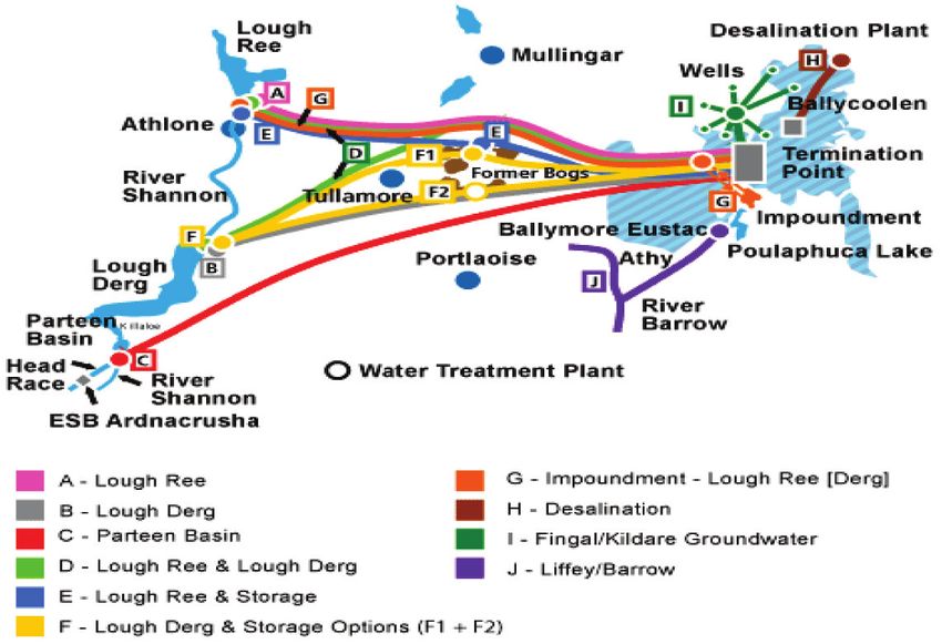
Executive summary

Executive summary

The scope                                                              Directive and the development and implementation
                                                                       of River Basin Management Plans (RBMPs). It
This report considers the links between water                          considers links between Regional Policy (4) and
management in the EU — especially the                                  water management in the EU, including the
implementation of the Water Framework Directive                        lessons from a spatial perspective. It further looks
(WFD) — and territorial cohesion (1), in the                           at cross‑country cooperation, a key element of
perspective of spatial analysis (2) and spatial                        both the WFD and territorial cohesion and finally
planning (3). It looks at the role of spatial analysis                 considers future challenges for implementation of
and planning for the implementation of the Directive                   the Directive and the development of RBMPs, in
as well as related provisions such as the Floods                       particular considering the spatial context.

Figure ES.1           Detailed framework providing an overview of the report

                                                                             Territorial cohesion

                                                                              Environmental
                                                                               dimension of
                                                                            territorial cohesion

                                                                                                                           Tools
                                                                                Environmental/
                      Cohesion policy                Water                       sustainability                        (e.g. IA, SEA,
           Other                                   Framework                      assets and                              EIA, GIS
           sector       Spending for                Directive                      benefits                              mapping)
                        water sector
           and
                        investments                 River basin
           environ-
                                                  management
           mental        Spending in              plans related
           policies         related
                                                    legislation:
                            fields:
                      inland waterways;          Floods Directive                Concepts, methods
                          hydropower                                               and approaches

                                                                                 (e.g. spatial planning,
                                                                                  green infrastructure,
                                                                                   ecosystem servies)

(1)   The concept of territorial cohesion builds bridges between economic effectiveness, social cohesion and ecological balance, putting
      sustainable development at the heart of policy design (p. 3 in Green Paper on Territorial Cohesion). See: http://eur-lex.europa.eu/
      LexUriServ/LexUriServ.do?uri=COM:2008:0616:FIN:EN:PDF for more information.
(2)   See http://en.wikipedia.org/wiki/Spatial_analysis for more information.
(3)   See http://glossary.eea.europa.eu/terminology/concept_html?term=spatial%20planning for more information.
(4)   See http://ec.europa.eu/regional_policy/index_en.cfm for more information.

                         Territorial cohesion and water management in Europe: the spatial perspective                                       5
Executive summary

    The issue                                                            approach on top of the existing administrative units
                                                                         such as the Bundesländer, creates overlaps and
    The spatial dimension is particularly important for                  potential conflicts in the jurisdictions and interests
    water management. The centre piece of EU water                       of key actors. While the new system addresses the
    legislation, the WFD, has a strong territorial context               previous problem of externalities that can occur
    and it is implemented through river basin districts,                 when water pollution or other problems created in
    which are based on natural geographic catchment                      one territory affects the environment in another, it
    areas rather than existing administrative boundaries.                requires a new level of interaction and negotiations
                                                                         among administrative units. The Directive thus
    A review of academic literature and initial work to                  creates a new element of complexity. In Germany,
    develop RBMPs shows that the links to these plans                    these difficulties have been addressed through
    and spatial analysis and planning are weak in many                   coordination mechanisms among the Bundesländer
    countries. One reason is that water management and                   that share RBDs.
    spatial planning have traditionally been carried out
    by separate structures and follow different traditions.              Another practical issue is that spatial planning and
    A practical obstacle is that spatial planning usually                river basin planning follow different timescales
    follows administrative boundaries, while RBMPs, in                   in most countries. However, this is related to a
    principal, follow topographic/geographic boundaries.                 broader issue, the lack of a legislative or policy
                                                                         framework at national or regional level to bring the
    The governance structures in the countries                           two planning processes together. A further problem
    face differing political, socio-economic and                         that has been identified in recent studies is the lack
    historical contexts which affect the way in which                    of shared knowledge and sufficient resources for
    administrative systems are managed. In Italy, for                    integration.
    example, regional borders only match those of river
    basin districts for the two large islands of Sardinia                In practice it appears that spatial planning has not
    and Sicily. Planning along natural geographic                        been strongly linked with the first round of RBMPs,
    boundaries is a new approach at EU level and                         completed in December 2009. A review of six draft
    in many countries as well. In contrast, spatial                      RBMPs (2009) found that less than half have strong
    planning is often a long-standing process. In some                   links with spatial planning. A review of countries
    countries, such as the United Kingdom, spatial                       in the Baltic Sea region found that spatial planning
    planning is hierarchical, with national or regional                  and water management remained separate systems
    plans providing a framework for those at the local                   in most countries; moreover, the implementation of
    level.                                                               the WFD had not brought stronger integration of the
                                                                         two.
    From an environmental perspective, planning for
    administrative areas that do not match natural                       These results show that much more work is needed
    geographic boundaries can create externalities: costs                to link spatial and river basin planning across
    can fall on those who do not benefit, as in the case of              Europe. At the same time, efforts to strengthen
    water pollution from agriculture and industry from                   these links are underway at national and regional
    one territory (5) that flows downstream to others;                   levels. Several trans-national cooperation projects
    and benefits may go to those outside the territory                   supported by EU Cohesion Policy funds have
    who have not paid for them — this can be the case                    brought together EU regions to develop new
    for ecosystem services such as those provided by                     methods and approaches.
    forests in one territory that regulate floodwaters
    downstream.
                                                                         Key findings and potential solutions
    Planning along natural boundaries such as river
    basins provides a way to address these externalities.                Potential synergies between spatial planning and
    In practice, River Basin Districts (RBDs) boundaries                 RBMPs can be strengthened. Spatial planning has
    co-exist with existing planning administrative                       a series of characteristics and approaches that can
    areas nonetheless. A study of the application of                     support the development and implementation of
    the Directive in Germany notes that this new                         RBMPs. For example, spatial planning:

    (5)   See http://inspire-forum.jrc.ec.europa.eu/pg/pages/view/1810/administrative-units for more information.

6   Territorial cohesion and water management in Europe: the spatial perspective
Executive summary

• brings a long-term, strategic focus covering large                the likely increases in population growth and hence
  areas, similar to the perspective of the WFD;                     water demand. The Dublin City Development Plan
• influences a broad range of economic sectors that                 2011–2017 (6) forecasts that Dublin's population will
  affect river basins through water consumption                     continue to grow over the medium term; there is no
  and pollution as well as the modification of water                explicit consideration of efforts to focus population
  bodies;                                                           growth in other areas, spatial or otherwise.
• influences the type and location of new polluting
  activities and thus water status;                                 The second spatial consequence stems from the
• can also be used to translate water management                    footprint and effects of the Greater Dublin Water
  goals — such as measures for more efficient                       Supply project; these are considered within the draft
  water consumption — into local government                         plan of the project (2008) and the accompanying
  action, for example for new housing                               SEA (SEA, 2008). The draft plan and SEA consider
  developments;                                                     10 different options for the provision of water
• shares a number of key tools with river basin                     for Dublin: these include greater abstraction of
  management planning, including Strategic                          groundwater, desalination of water from the Irish
  Environmental Assessment (SEA) and public                         Sea, abstraction from a variety of surface waters and
  participation;                                                    a range of different pipeline and storage options.
• is a key tool in addressing flood risks, drought                  Figure ES.2 shows the complete list of project
  risks and rural development.                                      options (option F is the final project).

The role of spatial analysis is, for example,                       Within the Greater Dublin Water Supply Draft Plan
illustrated in the Dublin metropolitan region                       each of these ten options was presented spatially
that has prepared a plan for a major new water                      and evaluated to understand the direct economic
supply system. There are two major spatial issues                   costs of the measures, with a focus on the costs
related to the proposed scheme; the first of which                  of infrastructure development. The Strategic
is Greater Dublin's growth over the medium term.                    Environment Assessment also identified a range
In determining the projected water demand the                       of environmental objectives based on the key
relevant regional plans were analysed to predict                    environmental issues in the likely affected area

Figure ES.2         The Dublin new water supply system


(6)   Dublin City Development Plan 2011–2017. See http://www.dublincitydevelopmentplan.ie for more details.

                        Territorial cohesion and water management in Europe: the spatial perspective                           7
Executive summary

    and used these objectives to appraise each of the          One important factor throughout sustainable flood
    project options. The scale and impact of abstraction       management is the restoration of inherent territorial
    were considered for each option, including                 features and the use of their ecosystem services,
    likely impacts on downstream water quality and             including floodwater retention. This approach
    quantity. However the presentation of the spatial          consequently uses environmental means to protect
    consequences of the various options could be               economic values.
    considered to be limited beyond water abstraction.
                                                               Several approaches can be used to strengthen
    Efforts have been made to build bridges between            links between spatial analysis and river basin
    land use planning and river basin planning. There          planning. RBMPs are the central mechanism for the
    are important links between spatial planning and           implementation of EU water legislation. These plans,
    RBMPs. Although the two systems do not appear              however, need to ensure two levels of integration:
    to be strongly linked at present, case studies have
    highlighted examples of approaches for integration.        • vertical integration with a range of EU
                                                                 requirements, with planning in other Member
    In Scotland, for example, government guidance sets           States in the same RBD and also with
    out steps for the integration of the two. The links          administrations at regional and local levels;
    are also strong in the Netherlands, where spatial          • horizontal integration among participating
    planning is used in a new initiative for flood risk          institutions and with stakeholders.
    management, 'Room for the River'. In the Flanders
    region of Belgium, as well, spatial planning is a part     Figure ES.3 illustrates the different elements to be
    of the SIGMA Plan to identify flood areas for the          addressed in the preparation of RBMPs.
    Scheldt River (this plan is carried out in cooperation
    with the Netherlands, as the two countries share           Moreover, the RBMPs need to bring together a range
    the Scheldt estuary). In both the Belgium and the          of methods, including spatial planning, climate
    Netherland cases, the flood management approach            change adaptation, flood risk management, and
    is strongly compatible with the environmental              drought and water scarcity management. They can
    dimension of territorial cohesion. One important           also address concepts such as green infrastructure
    factor throughout sustainable flood management is          and ecosystem services. Thus, a broader, more
    the restoration of inherent territorial features and the   integrative approach is needed for the revision of
    use of their ecosystem services, including floodwater      RBMPs in 2015.
    retention. This approach consequently uses
    environmental means to protect economic values.            A range of tools can support the task of preparing
                                                               and implementing RBMPs:
    The case studies illustrate two key issues. A first
    element is the growing importance of sustainable           • One instrument is SEA, which can be used to
    approaches to flood risk management, such as the             ensure that spatial plans address water goals,
    re-opening of flood plains and other actions to give         and that RBMPs incorporate environmental
    'room' to rivers. In many cases, such approaches will        goals in spatial plans; this mechanism can also
    also expand areas for biodiversity. A second point is        ensure that related plans, including spatial
    that the Floods Directive, with its requirement for          planning and the operational programmes for
    the mapping of flood risks and flood hazards, will           Cohesion Policy, are compatible with RBMPs.
    further strengthen the spatial dimension of EU water         The environmental impact assessment (EIA)
    legislation and also require greater use of spatial          of major projects needs to ensure that these
    tools. Consequently, there will be a greater need for        are compatible with RBMPs and will not cause
    spatial analysis and for links with spatial planning         failure for reaching good status of water bodies
    in the second round of RBMPs, due in 2015, as these          by 2015. Moreover, new tools, such as territorial
    are to include flood risk planning and also address          impact assessment (TIA) and water impact
    further issues, including water scarcity and droughts        assessment (WIA) can strengthen SEA and EIA
    as well as climate change impacts and adaptation.            methods.

8   Territorial cohesion and water management in Europe: the spatial perspective
Executive summary
Figure ES.3 River basin management plans: a framework for integration
Vertical integration, e.g. Horizontal integration, e.g.
EU institutions Cohesion Policy
Other Member States Spatial policies
(for cross-border RBDs) Coordination and conflict resolution
National mechanisms among institutions
Regional Stakeholder participation
Local
River basin management plan
Tools, e.g. Concepts, methods and
Economic analysis approaches, e.g.
Forecasts and scenarios for Spatial planning
climate, population, other factors Green infrastructure
Regional environmental Ecosystem services
characterisation Climate adaptation
SEA/EIA Flood risk management
Water accounting Drought and water scarcity
management
• Another approach is to enhance mechanisms • Regional environmental characterisation (REC) can
for integration. This can be done, for example, provide the information and the tool to assess
through voluntary guidance, an approach spatially the environmental impact of European
used at regional scale in France, where for policies at the regional level. Environmental
example the authority for the Adour-Garonne characterisation of territories can potentially
RBD has prepared a guidance document for provide baseline information about the
local authorities, for the integration of water environmental and natural assets, for example
management issues in urban planning. A further water of a specific region that makes it unique
method is to use a programme or initiative as or important and supports territorial identity
a mechanism for integration. This is seen in which would also help inform future policy like
France where the national programme for green the WFD. The major axes of the assessment were
infrastructure is to be implemented through the atmosphere, water and soil quality.
spatial planning system and should in turn be
linked to the RBMPs.
Territorial cohesion and water management in Europe: the spatial perspective 9Executive summary
• With outcomes from water accounting along with though other authorities and stakeholders have the
spatial information, three categories of outputs opportunity to participate in the overall process but
are now implemented and produce results not in the decisions. An 'interactive approach' on the
from prototype to pilot levels of integration: other hand, in which participation is much broader:
a) Water balances at monthly level at 'statistical other authorities and stakeholders contribute to the
unit' level, secondary aggregated at sub-basins definition of the problem and the identification and
levels ('territories of reference'), that are the implementation of solutions. The document notes
basis for detailed water use indicators; b) water that different approaches may be used in separate
quality accounts (7) at monthly level at 'statistical contexts within the same country.
unit' level, secondary aggregated at sub-basins
levels ('territories of reference'), that are the Cohesion Policy has major influence on water
basis for detailed water quality indicators; management in EU. Cohesion Policy is a central
and c) representative stratified statistics of the instrument for territorial cohesion at the EU scale,
relationships and trends category of pressure and the actions it finances will affect river basins
versus observation, at sub-catchment levels. and water bodies throughout the EU. A previous
A category being, for example, the 'intensive European Environment Agency (EEA) study
agriculture' or 'urban' activities. This last output showed that the EU Cohesion Policy funds have
is not water accounting in a narrow or strict sense played an important role in building wastewater
but constitutes a closely related side-product of treatment in the poorer regions of two Member
the water accounts implementation. The water States, Spain and Italy, and that in the current
accounts support The Blueprint to Safeguard spending cycle (2007–2013) the funds have
Europe's Waters (8) and can be used to quantify allocated significant resources in this area, in
how much water flows in and out of river basins. particular in the EU-12 Member States (EEA, 2009).
This will provide the basic essential information
which is largely missing today to optimise water The spatial dimension of Cohesion Policy is
uses at river basin level and look at alternatives, illustrated through a set of case studies. A review
in particular considering the material and virtual of spending on wastewater treatment in Estonia
water flows between catchments. extends the analysis in the 2009 EEA report and
shows that river basin planning has played a role
The tools discussed here provide an indication in identifying the investments financed through
of the environmental challenges facing Europe in Cohesion Policy.
coming years. Through their approach based on
natural geographic areas, the RBMPs under the A case study from Hungary looks at the plan
WFD offer the opportunity to address many of these to improve inland navigation along Hungarian
elements in an integrated approach. The spatial stretches of the Danube, highlighting potential
perspective will be increasingly important for the impacts on natural values of the river; this
success of RBMPs in coming rounds. The approach example is important as projects are underway or
of territorial cohesion will also be vital in linking in planning along other stretches of the Danube
actions for water management closely with those as well, and inland navigation more generally
in other policy areas that affect Europe's water is promoted at EU level as a freight mode that
environment. can reduce greenhouse gas (GHG) emissions in
comparison to road transport. The recent agreement
Strengthening the links between spatial planning calls for a balance between navigation plans and
and river basin planning can nonetheless be a environmental protection along in the Danube river
complex process, as successful methods need to be basin; its results will depend in part on the effects in
developed within the context of planning systems. spatial terms.
The Common Implementation Strategy (CIS)
guidance document on RBMP planning makes a Two other case studies show how the environmental
distinction between 'rational instrument' planning impacts of projects financed through Cohesion
on the one hand, which is top-down planning, Policy have been reduced through review and
(7) Quality accounting is an experimental approach of resource accounting. For most uses a quantity is a resource only if its quality
allows the uses. For more information see Section 2.2.4, Water accounting.
(8) See http://ec.europa.eu/environment/water/blueprint/index_en.htm for more details.
10 Territorial cohesion and water management in Europe: the spatial perspectiveExecutive summary
discussion. A plan to improve water quality in cross-country cooperation. These two strategies
Lake Balaton was restructured to emphasise positive cover economic, social and environmental
impacts on the Kis-Balaton wetlands area; in the dimensions and they are seen as practical measures
other study, the Jucar-Vinalopó water transfer for the implementation of territorial cohesion. At
project in Spain was modified to reduce effects on the same time, they coincide with geographic areas
water bodies. under EU legislation; the Baltic Sea is designated a
European marine region under the Marine Strategy
Cohesion Policy has also financed a range of Framework Directive (MSFD), while the Danube
cross-border and trans-national projects for water catchment area is the largest RBD under the WFD.
management: several of these have sought to While the strategies are at early stages, they can
strengthen spatial analysis in RBMPs and in flood provide an instrument for strengthening links
risk management. between Cohesion Policy, water management and
other EU policy areas.
These various examples have shown the importance
of Cohesion Policy on several levels: financing can What are the future challenges? RBMPs are to be
support the implementation of EU water legislation; revised every six years, and the first revision in 2015
at the same time, many projects financed through is to incorporate a range of issues, including flood
Cohesion Policy will affect water bodies and their risk management under the Floods Directive as well
impacts, including their spatial effects, need to as climate change adaptation. These new elements
be assessed before programmes and projects are point to the need to introduce longer term planning
approved. While the two policy areas show some and horizons into RBMPs and the related spatial
level of integration, further efforts are needed to analysis.
strengthen their coherence; spatial analysis may
have an important role to play in such efforts. Among the issues to be addressed are:
Cooperation on water management among countries • changes in population, as seen in France's
is essential. The RBDs set up under the WFD fast‑growing south-west;
cross national boundaries; indeed, 'international' • climate change impacts, such as higher
districts cover about 60 % of EU territory. Several temperatures and reduced precipitation forecast
major districts, such as the Rhine and the Danube, for much of southern Europe;
bring together several European countries. The • changes in the agriculture and energy sectors,
international RBDs create a new dimension for such as the rising cultivation of bioenergy
territorial cohesion among countries and regions, crops in Europe as well as plans for new, small
one that emphasises the connections along hydropower plants.
geographic boundaries and the need for cooperation
on shared ecosystems. These changes will need to be addressed through
spatial analysis and also via spatial planning. As
The Albufeira Agreement between Spain and mentioned previously regarding the Adour-Garonne
Portugal illustrates the cooperation mechanism for RBD in south-west France, for example, a recent
river basins shared between these two countries. guidance document discusses approaches to link
While this Agreement was reached in 1998, some river basin issues into urban planning, for example
of the practical steps for its implementation have to contain sprawl, especially in areas subject
proceeded slowly, for example with the creation of a to flooding. In Ireland and in the Netherlands,
joint secretariat only in 2008. however, major plans to accommodate expected
population growth suggest that further efforts
The 2009 Baltic Sea Regional Strategy and the 2010 are needed to ensure their links with river basin
Danube Strategy are broad-based approaches for planning.
Territorial cohesion and water management in Europe: the spatial perspective 11Introduction
1 Introduction
This report reviews the links between the WFD the environmental dimension of territorial cohesion
and territorial cohesion. Along with the WFD, the is generally poorly understood and needs to be
report also considers the Floods Directive and refers put on equal terms with the economic and social
to other European Union water legislation. The elements of the concept. Indeed, without a strong
analysis also considers the EU Cohesion Policy. It enunciation of the environmental dimension of
takes a pragmatic approach, by addressing several territorial cohesion, this concept could represent
areas where territorial cohesion, EU Cohesion Policy a step backwards in terms of European efforts for
and the WFD intersect, with the overall goal of sustainable development.
identifying ways that the EU can move forward in
terms of putting the environmental dimension of The previous study highlighted that there is no one
territorial cohesion into practice. Throughout the definition of territorial cohesion and is often used
report, the spatial perspective and spatial planning throughout the EU and its Member States with
provide a lens for analysis. differing shades of meaning. However, the previous
work recommended that territorial cohesion should:
Chapter 2 looks at the role of spatial analysis and
planning for the implementation of the Directive • foster a more balanced and harmonious
and the development and implementation of RBMPs development of the European Union;
in more detail. Chapter 3 considers links between • ensure that its citizens were able to use and
Cohesion Policy and water management in the EU, benefit from the inherent features of their
including the lessons from a spatial perspective. territories;
Chapter 4 looks at cross-country cooperation, a key • encompass the sharing of environmental
element of both the WFD and territorial cohesion. responsibility and benefits among territories and
Chapter 5 then considers future challenges for throughout the EU;
the implementation of the Directive and the • incorporate managing shared spaces, and
development of RBMPs, in particular considering addressing common concerns whilst working out
the spatial context. solutions for such environmental problems as
pollution, water management and mitigation of
and adaptation to climate change;
1.1 The environmental dimension of • include the preservation of natural assets and the
territorial cohesion protection of natural areas as well as protecting
the local ability to maximise gains from the
With the entry into force of the Lisbon Treaty on territorial capital — implicit in this are the ideas
1 December 2009, territorial cohesion, along with of resource efficiency and ecological balance;
economic and social cohesion, became a goal of • recognise local–regional–global linkages in
the EU as identified in the previous EU treaty considering the environmental facet of territorial
(Title XVIII). This part of the Treaty mentions the cohesion.
role of structural funds and the cohesion fund,
but does not clearly define 'territorial cohesion'. To ensure that sustainable development is pursued
However, the Green Paper on Territorial Cohesion throughout Europe, the concept of territorial
states (p. 3) that: 'The concept of territorial cohesion cohesion needs to incorporate the idea of sustainable
builds bridges between economic effectiveness, development — including the environmental
social cohesion and ecological balance, putting dimension.
sustainable development at the heart of policy
design.' Much has been written and discussed about the
need for a definition of territorial cohesion, but this
A previous study published by the EEA on has provided an elusive goal given the different
territorial cohesion (EEA, 2010c) highlighted that perspectives. Perhaps a more pragmatic approach
12 Territorial cohesion and water management in Europe: the spatial perspectiveIntroduction
is to focus on the process of achieving territorial This approach highlights the environmental
cohesion rather than its definition. As an initial dimension of territorial cohesion. It builds on
proposal, the previous study identified essential previous work, in particular by the European
elements of an environment and sustainability base Commission (EC, 2008a), as well as the idea
around the elements of territorial cohesion described that territorial cohesion represents 'the spatial
in the Green Paper: representation of sustainability' (Camagni, 2007).
Throughout all definitions is the idea that territorial
• harmonious and sustainable development; cohesion focuses on the spatial dimensions and
• inherent features of territories: natural features implications of European policies.
are protected for future generations;
• concentration: addressing differences in density Table 1.1 provides an overview of the environmental
and other natural features; dimension of territorial cohesion. Table 1.3 expands
• connecting territories: strengthening positive on these points and includes potential criteria to
natural connections and interactions between evaluate the environmental dimension of territorial
territories; cohesion in the light of the WFD and the Floods
• cooperation: overcoming division. Directive. Several case studies in the following
chapters use the elements of territorial cohesion for
analysis.
Table 1.1 Potential key elements of the environmental dimension of territorial cohesion
Green Paper on Territorial Cohesion key elements Potential key elements of the environmental
of territorial cohesion dimension of territorial cohesion
Harmonious development: Harmonious and sustainable development:
1. Building bridges between economic effectiveness, 1. Achieving sustainable development, and thus
social cohesion and ecological balance integrating economic, social and environmental
policy goals and actions
2. Putting sustainable development at the heart of
policy design 2. Environmental limits and carrying capacity
(as a constraint on economic growth)
3. Utilising a high quality environment as a good and
service (e.g. recreation, agriculture, tourism)
Inherent features of territories: citizens able to use Inherent features of territories: natural features are
the inherent features of their territories: protected for future generations:
1. Transforming diversity into an asset 1. Maintaining/improving natural capital — maintaining
local features and environmental quality
2. Making best use of territorial assets
2. Maintaining and enhancing current ecosystem
(three specific types of region are identified which can
services and recognising future needs
face particular development challenges: mountain
regions, island regions, and the 18 sparsely populated 3. Recognising vulnerability to environmental risks
regions, all rural and almost all border regions)
Concentration: overcoming differences in density: Concentration: addressing differences in density and
other natural features:
1. Avoiding excessive concentrations of growth
1. Addressing environmental problems related to
2. Facilitating access to the increasing returns of
concentration (e.g. pollution, water needs), including
agglomeration in all territories
negative effects within and among regions
3. Recognising that whilst most economic activity is
2. Recognising environmental/ecosystem services
concentrated in towns and cities, rural areas remain
an essential part of the EU providing most of the 3. Concentrated spatial patterns are better performing
natural resources and natural areas than low-density patterns (because of better energy
performance of buildings, and a possibility to develop
4. Ensuring sustainable territorial development
public transport facilities)
— strengthening economic competitiveness
and capacity for growth, while respecting the
preservation of natural assets and ensuring social
cohesion
Territorial cohesion and water management in Europe: the spatial perspective 13Introduction
Table 1.1 Potential key elements of the environmental dimension of territorial cohesion (cont.)
Green Paper on Territorial Cohesion key elements Potential key elements of the environmental
of territorial cohesion dimension of territorial cohesion
Connecting territories: overcoming distance or Connecting territories: strengthening positive natural
'strengthening' connections: connections and interactions between territories:
1. Ensuring good intermodal transport connections 1. Understanding environmental connections between
and within regions, e.g. water, materials, energy, and
2. Adequate access to services (e.g. health care,
making these connections more sustainable
education and sustainable energy, broadband
Internet access, reliable connections to energy 2. Recognising inputs and outputs (interdependences)
networks, and strong links between business and of environmental (and ecosystem) services within
research centres) and between regions at different scales
3. Recognising/avoiding negative environmental effects
from one region to another (e.g. pollution, climate
change — flooding, droughts, fires and biodiversity
loss)
4. Avoiding the environmental impacts of connectivity
(e.g. pollution, habitat loss, landscape intrusion)
Cooperation: overcoming division: Cooperation: overcoming division:
1. Addressing problems of connectivity and 1. Cooperation on implementing EU environmental laws
concentration through strong cooperation at different and policy at all levels (national, regional, local);
levels learning from different regions; supporting regions
to meet common environmental standards. This
2. Ensuring policy responses on variable geographical
section might encompass the 'traditional' view of
scales (e.g. neighbouring local authorities in different
environment in territorial cohesion and Cohesion
countries and between neighbouring countries)
Policy
3. Addressing environmental problems which do
2. Recognising the importance of natural as well as just
not respect borders and require cooperation
administrative boundaries in territorial governance
(e.g. problems associated with climate change)
4. Governance plays a major role in ensuring territorial
cohesion
1.2 The Water Framework Directive and to address major problems. These measures are
territorial cohesion to bring the surface water bodies in the district
to 'good status' by 2015; good status for surface
In 2000, the EU adopted the WFD (9) which sets waters involves both chemical characteristics (good
up the future frame for regulation and protection chemical status) and the health of their ecosystems
of water resources in Europe, comprising lakes, (good ecological status); groundwater bodies should
streams, coastal waters and groundwater (Table.1.2). attain good chemical status and good quantitative
The WFD summarises much of the European status (in that abstractions should not exceed
experience of pollution, water quality and natural aquifer recharge). The directive allows only
ecosystem management, and it represents a new limited possibility for extending the 2015 deadline,
and comprehensive way of source-to-sink thinking, achieving a lower standard or allowing deterioration
where the primary goals are to achieve the desired in conditions. For example, a failure to achieve good
quality of the water resources, to ensure that there is status is allowed under specific conditions; one is
enough clean water for different uses. that any modifications are of 'overriding public
interest'.
RBMPs must be prepared for each RBD and should
bring together an analysis of the characteristics of A previous EEA 2010 study on the Territorial
the water bodies with a programme of measures dimension of environmental sustainability (10), which
(9) Directive 2000/60/EC of the European Parliament and of the Council of 23 October 2000 establishing a framework for Community
action in the field of water policy (European Commission, 2000).
(10) See http://www.eea.europa.eu/publications/the-territorial-dimension-of-environmental-sustainability for more information.
14 Territorial cohesion and water management in Europe: the spatial perspectiveIntroduction
Table 1.2 Timetable for implementing the Water Framework Directive
Year Actions
2000 Water Framework Directive comes into force
2001 Common Implementation Strategy published
2003 Transposition into national legislation designation of RBDs and competent authorities
2004 For each river basin:
- Analysis of the natural characteristics, pressures and human impacts
- Economic analysis of water use
- Registration of areas needing special protection
2006 Operational water monitoring programmes
2008 Public consultation on proposed RBMPs
2009 River basin management plans with programmes of measures finalised
2009–2015 Implementation of programmes of measures
2010 Water pricing policies in place to promote sustainable use of water
2015 Achievement of good status for all surface waters and ground waters
reviewed the WFD in terms of the environmental The 2010 study also looked at the EU Floods
dimension of territorial cohesion, identified a broad Directive, which is closely related to the WFD and
range of synergies between the two. These include which itself has strong synergies with territorial
the following: cohesion. For example, the Floods Directive calls
for mapping and planning to address flood risks
• the Directive establishes governance by natural to protect human life, the environment, cultural
geographical units, river basin districts; heritage and economic activities. Further details
• it calls on Member States to cooperate on can be found in Table 1.3 which is based on the EEA
cross‑boundary RBDs; 2010 study and provides a review of the WFD and
• the Directive establishes a planning system at the the Floods Directive against the key elements of the
level of RBDs, and calls for public participation in environmental dimension of territorial cohesion.
river basin planning;
• it establishes the principle of the recovery of the Measures proposed by the WFD are explicitly
costs of water services, 'including environmental territorial in nature, for example the use of river
and resource costs' — this effectively recognises basins as the key planning unit, and managing
the value of ecosystem services. groundwater at risk, etc. The WFD also has
Table 1.3 Review of the Water Framework Directive and the Floods Directive against the key
elements of environmental dimensions of territorial cohesion
The tables below use the following scoring system for the 'overall assessment' against each of the five elements
of the environmental dimensions of territorial cohesion. This is based on a subjective assessment of the degree
to which the policy, etc. is considered synergistic or conflicting with the potential criteria listed in Appendix 1 to
evaluate the environmental dimension of territorial cohesion.
J Overall potentially synergistic
K Overall potentially neutral
L Overall potentially conflicting
Territorial cohesion and water management in Europe: the spatial perspective 15Introduction
Table 1.3 Review of the Water Framework Directive and the Floods Directive against the key
elements of environmental dimensions of territorial cohesion (cont.)
Elements of the Policy area: Water Framework Directive Overall
environmental assessment
dimensions
of territorial
cohesion
Harmonious
and sustainable
Potential synergies
The central aim of the WFD is to 'protect and restore clean waters across
J
development
Europe and ensure its long-term sustainable use'. Article 4(1) of the Directive
(Directive 2000/60/EC) includes the target for Member States to achieve good
status in all bodies of surface water and groundwater by 2015.
A key aspect of the directive is the aim for water services (clean drinking water,
irrigation, hydropower, wastewater treatment, etc.) to be charged at a price
which fully reflects the services provided. This explicitly recognises the value of
clean, sustainably managed water resources as a valuable good/service.
By seeking to charge the real cost (including externalities) of water use,
the WFD implicitly recognises the environmental limits of water resource
exploitation.
Potential conflicts
None identified.
Inherent features
of territories
Potential synergies
Fundamental to the WFD is the identification of 'water bodies' by Member
J
States. The designation of water bodies should consider the location, physical
characteristics and differences, as well as pressures such as extraction,
pollution, etc.
Inherent in the river basin scale management approach is the consideration of
interdependencies and relationships between territories.
The WFD proposal of inter-calibration of water ecosystem status across Europe
has the stated intention of enabling a common understanding of ecological
status given the different nature of water bodies between Member States and
regions (e.g. mountain lake compared to a tidal river).
Potential conflicts
None identified.
Concentration Potential synergies
The WFD requires Member States to designate artificial and heavily modified
J
water bodies, in which good ecological potential will need to be met
(differs from good ecological status targeted in other water bodies). Many of
these are likely to be within urban areas.
The incorporation of economic principles and water pricing in line with
environmental services provided is likely to help address some of the
water-related environmental pressures associated with higher concentrated
development, particularly water pollution, water resource scarcity, etc.
Potential conflicts
None identified.
Connecting
territories
Potential synergies
An explicit and key aspect of the WFD is the management of water issues at
J
the river basin scale. This recognises the inherent 'shared' nature of Europe's
water resources, rivers, lakes and seas.
Implementation of the WFD in relation to an international RBD should be
coordinated between those Member States in the district. Understanding and
managing inter-regional and trans-national water pollution/extraction will be an
important aspect of this cooperative approach.
Potential conflicts
None identified.
16 Territorial cohesion and water management in Europe: the spatial perspectiveIntroduction
Table 1.3 Review of the Water Framework Directive and the Floods Directive against the key
elements of environmental dimensions of territorial cohesion (cont.)
Elements of the Policy area: Water Framework Directive Overall
environmental assessment
dimensions
of territorial
cohesion
Cooperation Potential synergies
The consideration of natural boundaries and areas (in the form of RBDs and
J
water bodies) is a cornerstone of the WFD.
A cooperative approach to implementation is also a fundamental aspect of
implementation of the WFD.
Potential conflicts
None identified.
Elements of the Policy area: Floods Directive Overall
environmental assessment
dimensions
of territorial
cohesion
Harmonious
and sustainable
Potential synergies
The Floods Directive (Directive 2007/60/EC) requires Member States to
J
development
assess, map and plan for the management of flood risks in all water courses
and coastal areas in their territory. Flood risk assessment includes risks to
the environment, together with human health, cultural heritage and economic
activity. Flood risk management plans (to be development by 2015) should
focus on prevention, protection and preparedness.
Potential conflicts
None identified.
Inherent features
of territories
Potential synergies
Flood risk assessment under the directive is required to be undertaken at a
J
RBD and associated coastal area scale. Coordination is expected with RBMPs,
developed under the WFD. Accounting for interdependencies and relationships
between territories should be an inherent aspect of environmental management
at this scale.
The directive calls for flood risk management plans to be periodically reviewed,
and if necessary updated to take account of the impacts of climate change
on the occurrence of floods (e.g. paragraph 14, Article 4(2), Article 14(4),
Article 16).
Potential conflicts
In some cases flood risk management protection infrastructure may impact
upon protected areas/inherent features of territories, although this will depend
on implementation in individual Member States (and the intention of the
directive is that environmental features will be protected).
Concentration Potential synergies
The directive explicitly refers to urban floods (paragraph 10).
J
Flood risks associated with higher urban concentration (increased runoff,
reduced attenuation, etc.) are a significant issue in many urban areas.
Reducing flood risks may also address other environmental problems associated
with urban areas, such as water pollution (by reducing runoff).
Potential conflicts
None identified.
Territorial cohesion and water management in Europe: the spatial perspective 17Introduction
Table 1.3 Review of the Water Framework Directive and the Floods Directive against the key
elements of environmental dimensions of territorial cohesion (cont.)
Elements of the Policy area: Water Framework Directive Overall
environmental assessment
dimensions
of territorial
cohesion
Connecting
territories
Potential synergies
See entry under Inherent features of territories.
J
Paragraph 13 of the directive explicitly recognises the territorial connections in
relation to flooding (e.g. river corridors, coastal areas, international lakes). It
states that 'Member States should refrain from taking measures or engaging in
actions which significantly increase the risk of flooding in other Member States,
unless these measures have been coordinated and an agreed solution has been
found among the Member States concerned.'
Potential conflicts
None identified.
Cooperation Potential synergies
As noted, flood risk assessment and management is required to be at the
J
RBD and coastal zone level, and the directive explicitly promotes/requires
coordinated activity between and within Member States. For example
paragraph 6 of the directive requires coordination between Member States (and
cooperation with third countries) in recognition of the UN Convention on the
Protection and use of Transboundary Water Courses and International Lakes.
Flood risk management information exchange is a key aspect of the strategy to
support implementation (11).
Potential conflicts
None identified.
significant territorial impacts, through improving sustainable development — social, economic and
environmental quality in rural and urban regions, environmental progress — are fundamental to both
though agricultural regions will need to reduce regional spatial strategies and RBMPs. RBMPs can
pollution and urban areas will require better sewers therefore influence these regional spatial strategies
and water filtration systems. and other development plans, and in turn be
influenced by them.
For example in parts of England, major growth is
proposed where water resources and the ability to
handle increased volumes of sewage effluent, are 1.3 The role of river basin management
already constrained. Future development needs plans
to be planned carefully so that it does not result
in further pressure on the water environment The WFD introduces a new water planning cycle
and compromise the WFD objectives. Planning with RBMPs published in 2009 and subsequently
bodies and authorities hence need to think about at six-yearly intervals. The Directive specifies
the implications of proposed development and the key elements of the RBMPs (see Box 1.1 for
land use change on water, including beyond their a summary). These management systems are set
local authority boundary. The RBMPs required by up where all regions in Europe are divided into
the WFD are important new regional strategies hydrologically-based river basins, and for each of
that complement other regional strategies such these water management plans are to be developed.
as regional spatial strategies. The three pillars of There is particular focus on the control of emission
(11) See, for example, Promoting early action, Work programme and mandate 2008–2009, Working group F on Floods (as agreed by
the water directors, 29–30 November 2007). See http://circa.europa.eu/Public/irc/env/wfd/library?l=/framework_directive/floods_
programme/wg_f_floods/workprogramme_2008-9/_EN_1.0_&a=d for more details.
18 Territorial cohesion and water management in Europe: the spatial perspectiveIntroduction
• potential conflicts between inland navigation
Box 1.1 Key elements of river basin and ecosystem protection in rivers;
management plans • economic and social demands for water supply.
• mapping of:
As noted in Table 1.4, the case studies in the
– eco-regions;
following chapters address some of these potential
– surface water bodies and groundwater
bodies; conflicts; they also consider areas for potential
– protected areas; synergy arising from the WFD.
– monitoring networks.
• summary of significant pressures and impact The area of cooperation is particularly important
of human activity on surface and groundwater for RBMPs, both within countries as well as among
bodies; them. About 60 % of EU territory is covered by
• environmental objectives; RBDs that cross at least one EU or international
• economic analysis; border. Here, Member States are called on to
• summary of the programme of measures; cooperate on water management with the aim of
• register of more detailed programmes and
producing a single RBMP. For the Danube and
management plans;
Rhine rivers, common RBMPs have indeed been
• summary of public information and
consultation measures. prepared. For the Danube, Europe's largest river
basin, the common RBMP is then articulated by
international sub-basin plans as well as national
RBMPs.
of contaminants from industries, households and
agriculture to water bodies, and detailed action 1.4 Spatial planning in water
plans and monitoring systems should be developed management
in order to achieve the 2015 goals.
In the European Spatial Development Perspective
As can be seen from Box 1.1, mapping and thus (ESDP) document (12) agreed at the informal
spatial analysis are an important part of the plans, Council of Ministers responsible for spatial
at least in terms of characterising RBDs. Another planning in Potsdam, May 1999, risk of water
is the identification of environmental objectives, resources is mentioned as one of the critical spatial
an economic analysis, and the development development issues in Europe. An integrated
of a programme of measures to achieve the spatial development policy both for preventing
environmental objectives. As indicated in the last floods and for combating water shortages
bullet point in Box 1.1, public information and is considered important although these two
consultation are also important elements of the phenomena are of differing hydrological, political
RBMP process. and territorial significance.
The level of RBMPs allows a more detailed However, the two phenomena are important in
consideration of the links between the WFD and terms of sustainable spatial development as they
territorial cohesion. In particular, it is useful to both represent structural problems resulting from
consider this in terms of both the environmental inadequate adaptation of spatial development.
dimensions as well as the economic and social For example, as mentioned in the ESDP document,
dimensions of this term. Table 1.4 provides a brief floods have resulted in substantial damage to
analysis (it is based on the definitions of territorial private property and the economy. High water is
cohesion presented in Table 1.1 of this report). caused by a variety of factors, most of which are of
Several key issues and potential conflicts arise, man-made rather than natural origin, for example,
such as: the straightening of rivers, settlement of natural
flood plains and land uses which accelerate water
• the mismatch between river basin and runoff in the rivers' catchment areas.
administrative boundaries;
• related to this, the links between spatial Even in the drier regions of the EU, where rain
planning and river basin planning; occurs episodically but very intensively, there has
(12) See http://ec.europa.eu/regional_policy/sources/docoffic/official/reports/pdf/sum_en.pdf for more details.
Territorial cohesion and water management in Europe: the spatial perspective 19You can also read


