ECDIS Application and usability of - A MAIB and DMAIB collaborative study on ECDIS use from the perspective of practitioners - Danish Maritime ...
←
→
Page content transcription
If your browser does not render page correctly, please read the page content below
Application and usability of

EC DIS
A MAIB and DMAIB collaborative study on ECDIS
use from the perspective of practitioners

           1
CONTENT
Executive summary�������������������������������������������������������������������������������������������������������������������������iv

INTRODUCTION������������������������������������������������������������������������������������������������� 1
Introduction������������������������������������������������������������������������������������������������������������������������������������� 2
Methodology����������������������������������������������������������������������������������������������������������������������������������� 2
The report���������������������������������������������������������������������������������������������������������������������������������������� 3

SPECTRUM OF USE������������������������������������������������������������������������������������������� 5
Spectrum of ECDIS use������������������������������������������������������������������������������������������������������������������ 6

ECDIS USAGE & SAFE NAVIGATION�������������������������������������������������������������������� 9
Introduction����������������������������������������������������������������������������������������������������������������������������������� 10
Reliability��������������������������������������������������������������������������������������������������������������������������������������� 12
Workload �������������������������������������������������������������������������������������������������������������������������������������� 15

EMERGING CHALLENGES��������������������������������������������������������������������������������� 19
Introduction����������������������������������������������������������������������������������������������������������������������������������� 20
ENCs��������������������������������������������������������������������������������������������������������������������������������������������� 21
Route planning������������������������������������������������������������������������������������������������������������������������������ 29
Route monitoring��������������������������������������������������������������������������������������������������������������������������� 40
System design������������������������������������������������������������������������������������������������������������������������������� 52

CHANGE OF SKILL SET������������������������������������������������������������������������������������ 60
Introduction����������������������������������������������������������������������������������������������������������������������������������� 61
User reponses and observations�������������������������������������������������������������������������������������������������� 62
Discussion������������������������������������������������������������������������������������������������������������������������������������� 66

CHALLENGES TO SHIP OPERATORS������������������������������������������������������������������ 69
Challenges to ship operators�������������������������������������������������������������������������������������������������������� 70

CONCLUSIONS������������������������������������������������������������������������������������������������ 73
Purpose����������������������������������������������������������������������������������������������������������������������������������������� 74
Findings����������������������������������������������������������������������������������������������������������������������������������������� 74
Pathways to improvements����������������������������������������������������������������������������������������������������������� 78

APPENDICES�������������������������������������������������������������������������������������������������� 82

                                                                                           ii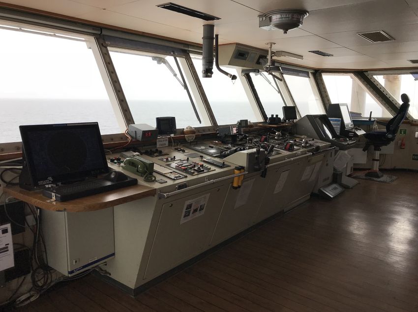
GLOSSARY OF ABBREVIATIONS
1/0 First officer
2/O Second officer
3/O Third officer
AHO Australian Hydrographic Office
AIO The admiralty information overlay
AIS Automatic identification system
ARPA Automatic radar plotting aid
ATSB Australian Transport Safety Bureau
BAM Bridge alert management
C/O Chief officer
CATZOC Category Zone of Confidence
DMAIB Danish Maritime Accident Investigation Board
EBL Electronic bearing line
ECDIS Electronic chart display and information system
ECS Electronic chart system
ENC Electronic navigational chart
ETA Estimated time of arrival
GLONASS Global navigation satellite system
GNSS Global navigation satellite system
GPS Global positioning system
HO Hydrographic office
HSC High speed craft
ICS International Chamber of Shipping
IEC International Electrotechnical Commission
IHO International Hydrographic Organization
IMO International Maritime Organization
INS Integrated navigation system
INTERTANKO International Association of Independent Tanker Owners
ISO International Organization for Standardization
LNG Liquified natural gas
LOP Line of position
MAIB Marine Accident Investigation Branch
MFD Multi function display
NAVTEX Navigational telex
NCSR IMO Sub-Committee on Navigation, Communications and Search and Rescue
OCIMF The Oil Companies International Marine Forum
OOW Officer of the watch
PSC Port State control
RIO Radar image overlay
SENC System electronic navigational chart
SMS Safety management system
SOLAS International Convention for the Safety of Life at Sea
STCW International Convention on Standards of Training, Certification and Watchkeeping for Seafarers
T&P Temporary & Preliminary [Notices]
UKC Under keel clearance
USB Universal Serial Bus
VRM The variable range marker
WGS World geodetic system
XTD Cross track distance
iii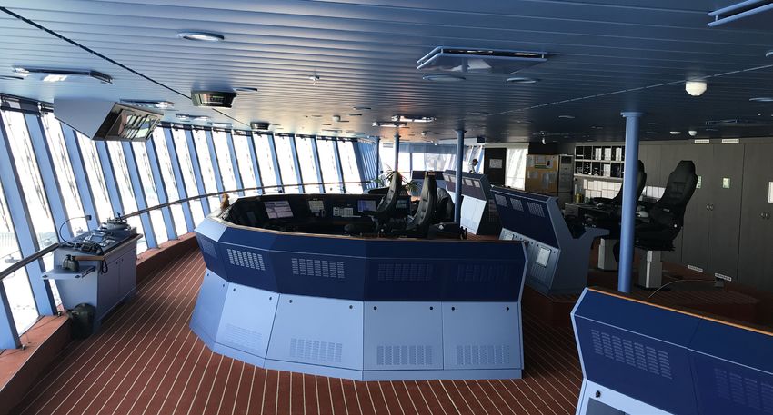
EXECUTIVE SUMMARY

BACKGROUND
In investigations of groundings since 2008 in which ECDIS were the primary means of navigation,
MAIB and DMAIB identified a mismatch between the way ECDIS was used and the intention of per-
formance standards and system design. This prompted the MAIB and the DMAIB to study ECDIS
use from the perspective of practitioners. The aim of the study was to generate an understanding
of the practical application and usability of ECDIS and support future ECDIS design, training strate-
gies and the development of best practices. The study followed a qualitative methodology, primarily
based on semi-structured interviews with 155 ECDIS users and observation data gathered between
February and July 2018 during sea voyages in European waters on 31 ships of various types.

FINDINGS
Spectrum of use
ECDIS use was contextual across a wide spectrum with practices dependent on type of ship, ship
trade and area of operation. This included ECDIS status (primary means of navigation, back-up
or navigation aid); ECDIS type (model/number/age) and level of integration with other equipment;
bridge layout and ergonomics; user familiarity and knowledge of the system; user experience; bridge
manning and organisation; on board procedures; trading patterns; masters’ preferences and level of
exposure to port state control, vetting and audit.

At one end of the spectrum of ECDIS use were paperless ships with a high level of bridge system
integration with purpose designed ‘cockpit-style’ bridge layouts, multiple ECDIS and multi-function
displays (MFD) integrated with sensors and systems via a data highway. At the other end of the
spectrum of ECDIS use were ships with a stand-alone ECDIS.

Within the spectrum of ECDIS use, some ships continued to carry paper charts in addition to ECDIS,
increasing the navigators’ workload as both media required correction/updating. In some cases,
passage plans had to be drawn on the charts as well as input to the ECDIS. Where paper charts were
the primary means of navigation, and ECDIS was a ‘navigation aid’ or for ‘training purposes only’,
ECDIS was used as the principal tool for navigation, but its safety features, such as the lookahead,
were often ignored. In effect, paper chart use was a compliance activity, limited to the periodic plot-
ting of positions ‘for the record’.

Overall benefits
Users identified the ECDIS’ main contributions to safe navigation as the reduction in workload and
the increase in situational awareness resulting from real-time positioning. ECDIS’ reliability and the
integration of ECDIS with other navigational systems were also seen as benefits. Given that the vari-
ous sources of information are usually accurate, and the users rarely experienced malfunctions, they
were generally found to trust the information provided by ECDIS and its technical reliability.

Some ECDIS functionalities were seen to reduce the manual labour of updating charts, plotting
routes using waypoints, etc., but these functionalities were not necessarily viewed as contributing
to safe navigation per se.

                                                  iv
Noticeably, the users who had experience working with paper charts specifically pointed to the
reduction of workload of manually plotting the ship’s position as the main advantage of the ECDIS,
because it freed up time to focus on other safety critical tasks, e.g. route monitoring and collision
avoidance. A majority of users found this functionality to be the most beneficial system functionality
of the ECDIS, because of the time saved. Presumably, the time gained is used for improvement of
the cognitive assessment of the navigational situation, i.e. more time for route monitoring, keeping
lookout, analysing the traffic situation, verifying the position by other means, interacting with the
pilot, etc. Thereby, the user can make more informed decisions about collision avoidance, manoeu-
vring the ship, etc. From the user perspective, having more time to assess the navigational situation
thus becomes the ECDIS’ main contribution to safe navigation.
Challenges
This study showed that while the standardisation and allocation of simple and repetitive tasks (plot-
ting the ship’s position and chart update) has brought about tangible benefits, the required user
interaction with ECDIS has introduced challenges that cut across system design, practices and
training. These challenges include:
• The distraction of alerts and alarms, particularly during pilotage, that leads to coping strate-
gies ranging between alarm ‘normalisation’ and physical disablement.
• The frequent impracticality of the setting of an efficient safety contour, leading to the use of
‘official workarounds’ (e.g. included in recognised guidance) and ‘unofficial workarounds’ (e.g.
alarm disablement) to optimise the display to make the best of a bad job. Alternatively, the
safety contour is ignored altogether.
• The number and types of alerts generated during automatic route checks that leads to them
either being ignored or increases the risk of planners missing safety critical alerts among nu-
merous more trivial ones.
• Interfaces and menu complexity that increase cognitive workload, particularly in busy en-
vironments, which results in users focusing on ECDIS to the detriment of other sources of
information.
• The difficulty of residual manual tasks such as planning radar parallel indices, plotting limiting
danger lines or writing text notes, which are often time-consuming, deters users from their
application.
• ECDIS requires significant cognitive resources to use its functions, which has contributed to
a minimalist approach by users.
• ECDIS use continues to be framed and audited within the context of paper chart practices
with Flag State, PSC and SIRE inspections often not recognising new ways of working such
as the use of radar information overlay to verify position.
• Users are trained to distrust the ECDIS and continuously verify the ship’s position by alterna-
tive means. However, significant discrepancies are rarely encountered.
CONCLUSION
From a user perspective, ECDIS does contribute to safe navigation, but the challenges that have
accompanied its introduction are problematic. Some of these challenges stem from the system’s au-
tomation not always working efficiently due either to the lack of bathymetric fidelity i.e the provision
of depth contours in the same manner as provided on paper charts and/or human-centred design
not being considered. Decisions to automate and ‘alarm’ the safety contour seem to have been
based on the technical ability to do so rather than on an adaptable blending of human and machine
capabilities to complete identified tasks in differing scenarios and environments.
vOther challenges seem to stem from industry inertia with ECDIS being viewed in the same way as
paper charts, i.e. a homogenous work process requiring a uniform skill set across different ships
and trades. However, ECDIS is not a standardised and automated paper chart. It is a technology
that provides a new form of situated knowledge by contextualising information from various sourc-
es, providing a different perspective on the navigational situation. ECDIS has expanded the bridge
watchkeeper’s role in maintaining the safety of a vessel by increasing the data available that requires
management, assessment and interpretation. It has also made navigational practices heterogene-
ous, necessitating different types of training, proceduralisation and technological solutions.
Although ECDIS use has been incorporated to some degree in the relevant conventions, the ‘best’
practices cited by many remain those often associated with paper charts with paper chart practices
remain at the heart of navigation training in nearly all maritime colleges worldwide. As ECDIS pro-
liferates, and ECDIS-related practices and skills develop, it seems impossible that such a strategy
can continue.
WHAT NEXT?
The findings of this study identify many of the problems ECDIS users experience with the system
at sea today, and in the short-term it is the ambition of the DMAIB and MAIB to engage with ECDIS
stakeholders to try to effect the changes required to improve ECDIS performance through better
bathymetry along with changes in design and training. However, the findings also point towards
deep-rooted, structural flaws in the way that new navigation technologies are implemented. Flaws
that continue to hinder system development and the evolution of new ways of working, and which
also promote reactive rather than proactive approaches in many areas.
Addressing such key issues will challenge traditional thinking and structures. It will also require in-
ternational liaison and agreement. Although no recommendations have been made it is hoped the
study will serve as a catalyst for change by the maritime industry to ensure that, among other things:
• The principles of human-centred design are followed.
• User experience is captured and acted upon both in terms of system functionality, training,
and practices.
• Core navigation training truly reflects the dominant use of ENCs compared to paper charts
and the changed role of the OOW brought about by automation.
From an accident investigation perspective, DMAIB and MAIB will present and discuss the study
with other AIBs with a view to sharing the benefits of qualitative research and influencing how acci-
dents involving interaction between the user and complex technological systems, such as ECDIS,
are investigated.
ACKNOWLEDGEMENTS
This study would not have been possible without the co-operation and assistance of ship owners
and operators, or without the trust, patience and openness of the participating seafarers. The DMAIB
and MAIB would like to thank all of those involved.
viINTRODUCTION
1INTRODUCTION
INTRODUCTION
Since 2008, the UK Marine Accident Investigation Branch (MAIB) investigations of groundings in
which Electronic Chart Display and Information Systems (ECDIS) were the primary means of naviga-
tion identified that the ways the vessels’ ECDIS were configured and utilised had been contributory
(see Table 1 in the appendix). There was a mismatch between the way ECDIS was used and the
intention of performance standards and system design. Common themes included passages being
planned across unnavigable water, voyage plans not being adequately checked visually or using the
automatic route check function, safety settings not matching the navigational context, and audible
alarms being disabled. Consequently, the knowledge and performance of the officers of the watch
(OOW) were called into question.
However, there was also evidence to suggest that the ECDIS did not fully meet the needs of the
end-user, and more recent accident investigation reports have identified issues related to the fidelity
and presentation of the underlying hydrographic data.
In 2018, the MAIB and the Danish Maritime Accident Investigation Board (DMAIB) agreed to investi-
gate ECDIS use from the perspective of practitioners based on the hypothesis that it was a combi-
nation of both usage, continuous development and design issues that contributed to the recurring
difficulties surrounding ECDIS use.
The aim of the study was to generate an understanding of the practical application and usability
of ECDIS that would benefit future ECDIS design, training strategies and the development of best
practices.
METHODOLOGY
Insufficient granularity and consistency in marine accident databases precluded any meaningful
quantitative analysis of ‘ECDIS-related’ accidents. Furthermore, as only the marine accidents with
significant consequences tend to be investigated, it was not possible to gauge the extent to which
the contributing factors identified in the accident reports referred to in this report were common or
whether the circumstances of these accidents were outside usual practice. Consequently, to gather
a broad perspective of how ECDIS was being used in differing contexts, the views of various stake-
holders, particularly the users, were sought.
The MAIB and DMAIB study was primarily based on interview and observation data gathered be-
tween February and July 2018 during sea voyages on 31 ships of various types. These included
cruise ships, tankers, bulk carriers, container ships, ferries, High Speed Craft (HSC) and service
ships. During these voyages, which were up to 4 days in duration on ships operating in European
waters, 155 ECDIS users were interviewed, comprising 24 nationalities, and the use of ECDIS from
eight different manufacturers was observed. The ages of the users varied from 21 to 62 years, and
participants were spread evenly over the range. All but 4 of the ECDIS users were male.
The framework for the semi-structured interviews comprised open questions on ECDIS themes such
as; advantages and reliability, disadvantages and unreliability, functionality, contribution to safe navi-
gation, near misses and automation surprise1, design, competency and training.
1 Situations where the operator is surprised by the behaviour of the automation asking questions like: ”What is it doing
now?” or ”Why did it do that?” or ”What is it going to do next?”.
2INTRODUCTION
Role specific questions were also put to masters and users responsible for passage planning in
order to gain an insight into ECDIS use from these perspectives. Each interview lasted on average
between 45 minutes and 1 hour. Following review of the interview data it was clear that saturation
had been reached for all aspects of the interview schedule and further interviews were unlikely to
produce novel insights.
The data from the interviews and observations was analysed to identify themes in an objective and
unbiased way. The purpose was to identify themes connected with ECDIS’ contribution to safe
navigation and difficulties with use. User responses were analysed to determine dominant themes
using NVivo qualitative data analysis software. Confirmation and theory biases were managed by
the MAIB and DMAIB analysing the responses independently. Some interviews were hampered by
language difficulties, so extra care was taken to confirm responses were appropriate to the question
being asked.
A spectrum of ECDIS use was identified with differing practices dependent on type of ship, ship
trade, area of operation, ECDIS type and other tangible variables. As the data gathered during the
study was highly contextual, no quantitative analysis was attempted.
Interviews were also conducted with 15 UK and Danish deep-sea pilots, 13 ship managers and ship
operators, five ECDIS manufacturers, ECDIS trainers and representatives of the hydrographic and
technical communities to gain insight into their views on ECDIS development, use and training. The
findings of published accident investigation reports, applicable International Maritime Organization
(IMO) and International Hydrographic Organization (IHO) documents, International Electrotechnical
Commission (IEC) technical standards, and academic papers and industry articles connected with
ECDIS use were also reviewed and referenced.
THE REPORT
The intended readership of this report comprises a range of groups, including cruise line operators,
shipping companies, maritime training institutions, authorities and legislators, affording them a de-
tailed view of the everyday operations surrounding ECDIS use.
Headline feedback on the study’s findings was provided at the IMO Sub-Committee on Naviga-
tion, Communications and Search and Rescue (NCSR) in January 2019, as well as through industry
working groups, seminars and conferences. This report represents a more complete analysis of the
data collected and emergent themes concerning ECDIS use. To make the findings of this study ac-
cessible and understandable to a wider audience, a discursive approach using as plain language as
possible, has been taken.
The report is organised as follows:
Part one introduces how the use of ECDIS is contextual depending on a variety of tangible variables
which influence the characterisation of the user views and observations presented in this report.
Part two begins with a description of how the IMO performance standards have an imbedded view
on how the ECDIS contributes to safe navigation. The users’ views on how ECDIS contributes to
safe navigation is then presented and discussed.
Part three describes and discusses the users’ perspectives on how ECDIS has brought about
emerging challenges to users and their navigational practices.
3INTRODUCTION
Part four describes the users’ perspectives on training and familiarisation and discusses how the
users are prepared to meet the new challenges introduced by ECDIS.
Part five briefly describes how ship operators experience the emerging challenges of ECDIS.
Part six presents high level conclusions from the discussions and pathways to improvement of
ECDIS.
41 SPECTR UM OF
USE
5PART 1: SPECTRUM OF USE
SPECTRUM OF ECDIS USE
The study identified a spectrum of ECDIS use with differing practices dependent on geographical
context (open, coastal or confined waters) and other tangible variables. These included: ECDIS sta-
tus (primary means of navigation, back-up or a ‘navigation aid’); ECDIS type (model/number/age)
and level of integration with other equipment; bridge layout and ergonomics; user familiarity and
knowledge of the system; user experience; bridge manning and organisation; on board procedures;
trading patterns; masters’ preferences and; level of exposure to port state control, vetting and audit.
At one end of the spectrum of ECDIS use were paperless ships (e.g. HSC, modern cruise ships) with
a high level of bridge system integration with purpose designed ‘cockpit-style’ bridge layouts (Fig-
ure 1), dedicated seated control stations and multiple ECDIS and MFD integrated with sensors and
systems via a data highway. ECDIS were also sited remotely in locations such as the master’s cabin.
Users on these paperless ships viewed ECDIS as just one component of the wider ‘bridge system’
with voyages being monitored using automatic radar plotting aid (ARPA) radar with a chart underlay.
Bridges were routinely manned by two officers, both of whom had been familiarised with the bridge
system (post generic ECDIS training) using ‘in house’ full mission bridge simulators and working to
company procedures. The simulators were also used to develop navigation practices and bridge
resource management techniques. Onboard procedures were ship specific and included forms for
under keel clearance (UKC) calculation and guidance on ECDIS settings on the various voyage
phases. Passage planning was conducted by a first/chief officer, supported in associated tasks,
such as chart supply and update by other officers. Passage plans were sent to management ashore,
who monitored voyages remotely. System resilience was provided through multiple ECDIS and hav-
ing trained electro-technical officers onboard capable of diagnosing/resolving system problems.
Manufacturer support was also available.
Figure 1: Bridge layout on a modern cruise ship
6PART 1: SPECTRUM OF USE
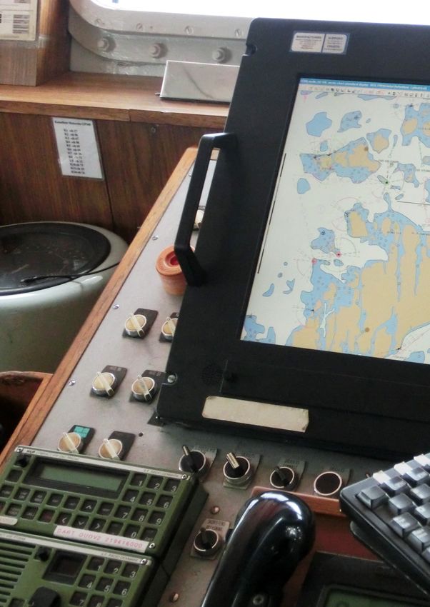
At the other end of the spectrum of ECDIS use were ships (e.g. ferries, bulk carriers), including new-
builds, with a stand-alone ECDIS (Figure 2). The positioning of retro-fitted ECDIS was usually de-
pendent on the space available and typically left to the preference of the technical superintendents
and masters. Frequently, this resulted in the primary (monitoring) ECDIS being at the front of the
bridge and the ‘back-up’ (planning) ECDIS by the chart table at the back of the bridge. Other than the
Automatic Information System (AIS), the ECDIS had only the mandatory input from sensors required
by standards. The layout required OOWs on these vessels to move around. They had completed ge-
neric ECDIS training, but the requirement for familiarisation training tended to be met through either
on-board checklists, computer-based training or short shore-based courses. Onboard procedures
had been modified from those used for paper chart navigation and were generic in nature. Passage
planning was carried out by a second officer (2/O). System resilience was provided either by a single
‘back-up’ ECDIS, the carriage of paper charts and/or by having access to manufacturer support
ashore.
Figure 2: Bridge layout on a cargo ship
7PART 1: SPECTRUM OF USE
Within the spectrum of ECDIS use, some ships continued to carry paper charts in addition to ECDIS,
reflecting a reluctance by some ship operators to commit to paperless navigation. Study data, sup-
ported by an Oil Companies International Marine Forum (OCIMF) and International Association of
Independent Tanker Owners (INTERTANKO) online survey of their members during 2019, showed
that the simultaneous carriage of paper charts and ECDIS increased the navigators’ workload with
both media requiring updating. On board ships where paper charts were the nominated ‘back up’
for the ECDIS, passage plans also had to be drawn on the charts as well as input to the ECDIS,
which further increased the workload. Where paper charts were the primary means of navigation,
and ECDIS was a ‘navigation aid’ or for ‘training purposes only’, ECDIS was observed to be used as
the principal tool for navigation, but its safety features, such as the lookahead, were often ignored.
In effect, paper chart use was a compliance activity, limited to the periodic plotting of positions ‘for
the record’.
The focus on the spectrum’s extremes is not meant to imply that navigation at one end of the spec-
trum is ‘safer’ or ‘better’ than at the other. The extremes are just different, with most ECDIS use
occupying the middle ground with various combinations and permutations of the factors identified,
which made it impossible to define a single characterisation of ECDIS use.
82 ECDIS USAGE &
SAFE NAVIGATION
9PART 2: ECDIS USAGE & SAFE NAVIGATION
INTRODUCTION
Amendments to the International Convention for the Safety of Life at Sea (SOLAS) which came into
force in 2011 mandated the carriage of ECDIS for ships on international voyages. ECDIS carriage
thus became compulsory for various vessel types and sizes subject to a staged entry into force
between 2012 and July 2018. For ECDIS to satisfy carriage requirements, it must meet certain spec-
ifications. The ECDIS must be type-approved and meet IMO performance standards2.
The IMO performance standards state that the primary function of the ECDIS is to contribute to safe
navigation, but they do not explicitly state how the systems should achieve this goal. However, the
performance standards mention two main qualities, which the system should deliver, that implicitly
contribute to navigational safety: reliability and functionalities to reduce the user’s workload includ-
ing the integration of the ECDIS with other bridge systems.
Reliability is obtained by the system displaying chart information from a government authorised
hydrographic office (HO), which can be reliably updated, and adequate back-up arrangements, i.e.
system redundancy in terms of hardware, software or even paper charts. In a situation where the
equipment malfunctions or is not reliable, the system will notify the mariner by an alert.
Functionalities to reduce the workload are aimed at enabling the user, in a timely and convenient
way, to execute all route planning and route monitoring assisted by continuous plotting of the ship’s
position. Continuous plotting refers to the real-time presentation of information, which should re-
duce the workload of manually plotting positions using various sources and methods. The user can
be aided in route monitoring by the system providing alerts about the information displayed. This
is meant to improve their cognitive assessment of the navigational situation, i.e. users will be less
busy monitoring the route, because they will automatically, among other things, be alerted about
deviation from track, the approach of a wheel over and the danger of grounding. Bridge systems
integration is meant to assist the user in monitoring the route progress by integrating the ECDIS with
other equipment, e.g. echo sounder, AIS, radar and ARPA functionalities. It is uncertain how system
integration is meant to aid route monitoring, but arguably it reduces the user’s workload by providing
information on a single display, enabling the user to retain an overview of the navigational situation
by looking at only one screen.
The IMO standards’ notion of what constitutes a contribution to safe navigation can thus be sum-
marised as a reliable chart system offering various functionalities including bridge system integration
aimed at reducing navigational workload.
It is up to the manufacturers to resolve how the goals of the system standards are translated into
specific design features via international technical standards. (Since the first type approval of ECDIS
in 1998, the associated IEC standards have been under constant review and have grown signifi-
cantly in volume, but further changes seem inevitable.) These features are continuously developed
to give the manufacturers a competitive advantage by adding system functionalities and improving
user-friendliness in an ongoing design process. This means that the manufacturers are continuously
making changes to the systems in the attempt to meet various customer demands, while still effec-
tively meeting the criteria set out in the standards. Where the standards allow little margin for meet-
ing user wants, i.e. optional extras that would be helpful but not essential, manufacturers are also
developing ‘back of bridge’ aids, such as planning stations with extra-large displays that by-pass
ECDIS requirements. This design process has resulted in disparities in system features amongst
ECDIS makes and models.
2 Res. A.817(19) adopted on 23 November 1995 (Performance standards for electronic chart display and information sy-
stems (ECDIS)) and Res. MSC.232(82) adopted on 5 December 2006 (adoption of the revised performance standards
for electronic chart display and information systems (ECDIS)).
10PART 2: ECDIS USAGE & SAFE NAVIGATION
The development of increasingly advanced system features and the increased integration of bridge
systems mean that the ECDIS becomes more than a reliable navigational chart on a screen. It be-
comes a system that changes navigational practices by enabling the user to access a variety of
information to solve other tasks, e.g. executing a turn in real-time or aiding in decisions related to
collision avoidance. Arguably, the performance standards did not envisage the extent to which the
navigational practices would change as the ECDIS evolved with added functionality and increased
bridge system integration.
Before electronic chart systems (ECS) were introduced, paper charts as the primary means of navi-
gation were a commonality of most ships, and paper-based navigation was a core skill for all OOWs.
Therefore, the IMO performance standards use paper charts as a benchmark and reference paper
charts when determining the minimum standard of reliability of the ECDIS.
Consequently, the IMO performance standards do not explicitly refer to the ECDIS user and the
user’s navigational context. Because the ECDIS is not meant to change the OOW’s core skills and
fundamental navigational practices, e.g. when stating that the system “… should enable a mariner
to execute in a convenient and timely manner all route planning, route monitoring and positioning
currently performed on paper charts …” The assumption underpinning the performance standards is
that the ECDIS provides a reliable chart on a screen with the added benefit that the manual workload
is diminished by automating the manual paper chart work.
“ ECDIS manufacturer: From the outset, the design criteria for ECDIS was
that the user should be able to do exactly what was done using paper
charts.
As mentioned in the introduction, findings from casualty investigations suggested that there was a
mismatch between the way ECDIS was used and the way regulators and the system manufacturers
expected it to be used as a contributor to safe navigation. A discrepancy which may, in part, have
been caused by the continuous development of the ECDIS as more than a paper chart on a screen.
This suggests there might be a discrepancy between the IMO performance standards’ notion of safe
navigation and the ECDIS users’ view of the same.
This safety study thus focused in part on the users’ perspective on how the ECDIS contributes to
safe navigation by offering reliability and by decreasing the users’ workload.
11PART 2: ECDIS USAGE & SAFE NAVIGATION
RELIABILITY
IMO PERFORMANCE STANDARDS
1.2 ECDIS with adequate back-up arrangements may be accepted as complying with the up-to-date
charts required by regulations V/19 and V/27 of the 1974 SOLAS Convention, as amended.
1.7 ECDIS should have at least the same reliability and availability of presentation as the paper chart
published by government authorized hydrographic offices.
IMO Res. 232(82) adopted 2006
USER VIEWS
An ECDIS comprises hardware (personal computer (PC), screen, keyboard, etc.), software (run-
ning presentation library, on-screen user interface etc.), hydrographic data on Electronic Navigation
Charts (ENC) and various sensor inputs (Global Navigation Satellite System (GNSS), echo sounder,
etc.). These system components have different reliability criteria, e.g. the ENCs must contain de-
pendable information comparable to paper charts, the software must be able to reliably present
the hydrographic data, and the hardware must be able to function by meeting certain mechanical
standards and by having hardware redundancy.
Most of the users interviewed did not explicitly distinguish between the different system components
when asked about the reliability of the ECDIS, i.e. there was no explicit distinction between reliability
related to hardware, software, ENC data or sensor input.
“ C/O, RO-RO passenger ship: Reliability, that’s a lot of things. So, there is
reliable information and there is technical reliability …
Among users interviewed, two implicit conceptions of reliability stand out: technical reliability and
information reliability. Technical reliability pertains to the reliability of the technological components,
i.e. how likely are breakdowns to occur, and information reliability concerns the accuracy of the dis-
played information, i.e. accuracy of the hydrographic data and GNSS input accuracy.
The majority of users were found to have a view of the ECDIS as being a reliable technical system,
despite some reservations regarding computer-based systems and experience of occasional mal-
functions where they had to rely on either the redundant ECDIS or navigate by other means, e.g.
using radar or by visual bearing using buoys, landmarks, etc., albeit for a short period of time.
Although reports by ship managers indicated there had been occasions where ECDIS functionality
has been entirely lost, these appear to have been infrequent. Users seemed to cope with the minor
technical and interface issues, which didn’t detract from their positivity over the system’s reliability
and accuracy.
“ C/O, container ship: … we rely on ECDIS a lot and I think it is reliable.
“ C/O, car carrier: … we trust the ARPA so why not trust the ECDIS.
12PART 2: ECDIS USAGE & SAFE NAVIGATION
“ 3/O, general cargo ship: When I have the radar and the ECDIS and I can
look out the windows, I have three sources of information to establish
where I am and what I see, and I think when I combine the three I have a
more reliable picture.
Technical reliability is basically viewed as the ECDIS’ ability to consistently solve specific tasks in
the daily navigational practices, e.g. updating charts, planning routes, transferring data between
workstations, etc. The reliability of the ECDIS is brought into question when the system components
malfunction, making task solving difficult, e.g. when updating the ENC database fails, because the
computer processor is slow or there is a lack of computer storage capacity. These technical mal-
functions are often immediately manifested, causing frustration and mistrust of the system.
“ 2/O, passenger ship: When it’s not working, I think. If there is something
wrong with the ECDIS, or there is something I can’t figure out, then sud-
denly your mind goes circling around this problem, instead of just navigat-
ing … Then you think: Oh, who can I call? I need this thing to work.
When the ECDIS does not function as expected, the user must diagnose the problem as either a
technical malfunction or an operator error. This diagnostic process requires the passage planner to
be an expert user.
“ C/O, passenger ship: Yes, I have sometimes experienced anomalies. But
then I investigate it, and it is usually about me not knowing enough about
the system.
Some users were found to be more prone to experiencing technical problems than others. Those
responsible for chart updates, loading ENCs and passage planning experienced more malfunctions,
because they were the first to meet the limits of the hardware and software. But they were also the
users who were more experienced with the system and were called upon to diagnose problems. This
could explain why some users generally considered the ECDIS to be technically reliable, while other
users were considerably more sceptical.
Most ships did not have onboard planned maintenance of the ECDIS components and did not carry
spare parts, e.g. hard drive, ventilation fans, displays, etc. They mainly relied on having expertise
from ashore to repair the ECDIS whenever a problem occurred. The trust in the system thereby pri-
marily resulted from having a spare system rather than by maintaining the system in use to a high
standard.
Generally, users were positive about the reliability of the information displayed on the ECDIS when
monitoring the ship’s position, both in terms of sensor accuracy and the quality of the hydrographic
data. When questioned about ECDIS reliability, the majority of users referred to the Global Position-
ing System (GPS) as the primary potential source of inaccuracy, which necessitated position verifi-
cation by the use of line of position (LOP) or by visual observation of e.g. buoys or landmarks. Once
the accuracy has been established, the users tend to put trust in the system, e.g. when navigating in
confined waters or in port areas.
“ Master, passenger ship: … if we are talking position accuracy, I find it very
reliable, and I actually use it for my harbour-manoeuvring, so I find it very
reliable.
“ C/O, container ship: To maximise the reliability of the ECDIS it is important
to challenge the data by all available means.
13PART 2: ECDIS USAGE & SAFE NAVIGATION
It was noticeable that few users referred to the underlying hydrographic data as a potential source
of inaccuracy. Few users understood the different zones of confidence (CATZOC) and why these
categories could affect the planning and monitoring of the passage. During observations it was not
seen that users interrogated the chart for information about accuracy. It could be that the ENCs they
were navigating with presented accurate hydrographic data because the waters were well surveyed,
or the users were familiar with the area and followed well established safe tracks and therefore did
not notice that the hydrographic data was inaccurate. The exception was users on ships navigating
in Greenland waters, which are known to be poorly surveyed. In those areas the users did not rely on
the ECDIS and consequently mainly navigated using the radar and parallel indices. The subject of
the users’ trust in ENCs and the underlying hydrographic data will be further elaborated in the next
chapter: Emerging Challenges.
DISCUSSION
When looking to the users’ views on the reliability of ECDIS, it was found that overall they had a
positive outlook across different types of ships and trades. The majority of users found the various
chart systems to be technically reliable, and they had confidence in the quality and accuracy of the
information displayed.
Users tended to view the ECDIS as one system and not an information platform consisting of vari-
ous sources of information with different criteria for reliability. Therefore, some did not systematically
distinguish between quality of hydrographic data versus sensor input accuracy, e.g. when assessing
the accuracy of the ship’s position displayed on the ECDIS. Arguably, ENCs may give the impression
that the displayed hydrographic data is more reliable than paper charts. Therefore, the users focus
on verifying the reliability of the GNSS sensor input (which will set off an alarm if in error), rather than
the accuracy of the ENC.
“The modernity of ECDIS obscures the fact that the system may be reliant on
ENCs with a very low level of reliability.”
Digital navigation: Old skills in new technology – Lessons
from the Grounding of the Nova Cura, DSB, 2017
Two opposing views exist about the reliability of the information provided by the ECDIS. On the one
hand, users experienced that the ECDIS consistently provides reliable information, e.g. accuracy of
the plotted position. On the other, they are trained to distrust the ECDIS and continuously verify the
ship’s position by alternative means to the GNSS input, due to unforeseen discrepancies to which
the system will not alert the user. Such distrust, which is traditionally expected of OOWs, is chal-
lenged, because such discrepancies are rarely encountered.
The majority of users did not necessarily consider the individual sources of information when eval-
uating the reliability of the information provided by the ECDIS. The reliability of information is thus
evaluated by assessing how the system as a whole performs in a specific navigational situation. Giv-
en that the various sources of information are usually accurate, and the system rarely malfunctions,
the user tends to trust the ECDIS, in terms of accuracy of the information provided by sensor input,
hydrographic data and the reliability of the technical components.
So, although the ECDIS is generally considered to be reliable, the practical reality of training and
working routines nonetheless often involves doubting the system and alarms, thus detracting from
the overall contribution to safe navigation.
14PART 2: ECDIS USAGE & SAFE NAVIGATION
WORKLOAD
IMO PERFORMANCE STANDARDS
1.5 ECDIS should reduce the navigational workload compared to using the paper chart. It should
enable the mariner to execute in a convenient and timely manner all route planning, route monitoring
and positioning currently performed on paper charts. It should be capable of continuously plotting
the ship’s position.
IMO Res. 232(82) adopted 2006
USER VIEWS
The IMO performance standards point to four ECDIS functionalities which are aimed at reducing the
workload: The automation of chart updates, route planning, real-time positioning and route moni-
toring.
Users who had experience from ships carrying paper charts pointed to the automated update of
charts as a positive because the manual workload had been significantly reduced. However, the
reduction in the workload was not characterised as a contributor to safety per se, presumably be-
cause the updates were mainly performed while the ship was in open water with little traffic or when
the navigational officer was not performing watchkeeping duties. Users who had never used paper
charts typically referred to anecdotal information about the added benefit of automated updates.
None of the users referred to increased accuracy in chart updates as an advantage of automated
updates.
“ 2/O, passenger ship: ... you do not have to manually update the ECDIS like
you have to with the paper charts – with glue, and all the stuff.
“ 2/O, passenger ship: I can easily see when it’s been updated last, and if
I suddenly go into a new area I can quickly, within a few minutes, get an
update and install it on the PC.
When asked about the benefits of ECDIS route planning functionalities there was no specific ref-
erence made to how the route planning functionalities contributed to safe navigation. The users
focused on how the various route planning functionalities made certain work tasks easier compared
to working with paper charts, e.g. loading new routes, making a list of waypoints, plotting waypoints
and courses, etc. Distinctively few users pointed to the ECDIS route check as a contributor to safety
or reduction of workload.
“ C/O, ferry: We have one-hour port stay, then you just click deactivate the
previous route and activate the next route and then you’re ready to go.
“ 2/O, RO-RO cargo ship: It saves a lot of time. For example, when you have
to change route when we are sailing.
“ C/O, container ship: … when you have to make new routes, this is much
faster than if you should do it in paper charts, of course you have all the
waypoints and you can print a waypoint, and make a print with all the way-
point positions, instead of you have to make all this manually.
15PART 2: ECDIS USAGE & SAFE NAVIGATION
“ 2/O, passenger ship: If you do not work a lot with the ECDIS then it is faster
to make the route in the paper charts if they are corrected. However, calcu-
lating distances is slower, but plotting the courses is quicker.
Continuous automated plotting refers to the real-time positioning of the ship on the ECDIS by a
GNSS sensor input. The majority of users found this functionality to be the most beneficial system
functionality of the ECDIS because time is saved by not having to manually plot the ship’s position
on the chart using information from e.g. the GPS and/or radar.
“ C/O, RO-RO passenger ship: … in position monitoring you have more fo-
cus on looking out of the windows and monitoring your radar ... I get a
quick overview and I have more focus on navigation instead of going back
and forth and looking at a paper chart.
“ C/O, passenger ship: You save time… you become less busy instead of
looking at the paper chart you can look out the window and the radar.
“ 2/O, general cargo ship: Close to shore. When you’re close to shore it
saves time that you don’t have to run back and forth plotting the ship’s
position manually.
“ Deep sea pilot: Now, you know where you are. And you can focus on
anti-collision, and you don’t have to run around plotting positions all the
time, to be sure that you’re in the right place …
Users were not consistent in expressing how the continuous automated plotting was an advantage
besides being less labour intensive than manual plotting. Presumably, the time gained is used for im-
provement of the cognitive assessment of the navigational situation, i.e. more time for route monitor-
ing, keeping lookout, analysing the traffic situation, verifying the position by other means, interacting
with the pilot, etc. Thereby, the user can make more informed decisions about collision avoidance,
manoeuvring the ship, etc. Having more time to analyse the navigational situation in terms of decon-
flicting oncoming traffic, collision avoidance and manoeuvring the ship thus becomes the contributor
to safe navigation. During the study it was observed that users only sporadically used the ECDIS in
open waters with little traffic indicating that the advantages of having this real-time mental model of
the navigational situation was found to be more prevalent in busy and/or confined waters. This ob-
servation coincides with the findings from research on how frequently seafarers utilise functions and
information available on an integrated navigation system (INS) to perform navigation duties.In open
sea the advantage of continuous plotting was found to be minimal, because navigational dangers
are few and far between.
“The study showed that during route monitoring the most used system features
were display of own ship’s position and XTD.“
Vu, Lützhöft and Emad, Frequency of use – the First Step To-
ward Human-Centred Interfaces for Marine Navigation Sys-
tems, The Journal of Navigation, 2019
16PART 2: ECDIS USAGE & SAFE NAVIGATION
The users found the INS to contribute to safe navigation by providing the means to verify the ship’s
position and for collision avoidance. Instant position verification was obtained by using radar/ENC
overlays to assess GNSS accuracy and hydrographic quality, AIS sensor input was used for long-
range traffic deconfliction, and the traffic situation was observed and mitigated in conjunction with
navigational decisions. ECDIS is thus viewed as a system which assists the OOW in a multitude of
tasks, e.g. establishing the position of the ship, collision avoidance, manoeuvring, providing informa-
tion about weather, etc. This view of the ECDIS is concordant with the IMO performance standards’
intentions for INS, namely that INS may assist route monitoring by providing the user with infor-
mation on a single display, enabling the retention of an overview of the navigational situation, and
reducing cognitive workload.
DISCUSSION
It was found that the majority of users across different types of ships and trades, have an overall
positive opinion about the ECDIS’ contribution to the reduction of workload. However, ECDIS users
are not a homogenous group of professionals, therefore a significant variation was found among the
user responses to the various workload topics.
ECDIS users have developed different navigational practices depending on various factors, e.g.
type of ship and the trading area the ship is operating in. On a passenger ship operating in regular
domestic service, the planners will not use ECDIS route planning functionalities as regularly as on
an oil tanker in tramp service. An OOW on a general cargo ship in arctic waters primarily relies on
radar navigation, whereas an OOW on a cruise ship in the Mediterranean predominantly relies on the
ECDIS for real-time navigation and route monitoring. Additionally, there was a significant disparity
between users who had witnessed the transition from paper chart to ECDIS and users who had only
used ECDIS.
“… the survey shows that the use of navigation systems is situation depend-
ent, and the mariners require different sets of functions and data for different
scenarios …“
Vu, Lützhöft and Emad, Frequency of use – the First Step
Toward Human-Centred Interfaces for Marine Navigation
Systems, The Journal of Navigation, 2019
The users were found to have a varying depth of knowledge and experience in the use of ECDIS
depending on the training and familiarisation they had received, affecting their view on the system’s
ability to reduce the navigational workload. Some users have little knowledge about the system
functionalities and view the ECDIS as a paper chart on a screen and only use the basic functions
of the ECDIS. Those users who had misconceptions about how the ECDIS is designed to be used
tended to underestimate the workload required when e.g. planning a route or updating charts with
Temporary and Preliminary (T&P) notices corrections. Others who were more proficient in the use of
ECDIS rely on the ECDIS to provide them with all essential information and use many of the system
functionalities. These differences among the users shaped their perception about how much work
was required when using the ECDIS.
17PART 2: ECDIS USAGE & SAFE NAVIGATION
The ECDIS functionalities were perceived to reduce the manual labour of updating charts, plotting
waypoints, etc., but these functionalities were not necessarily viewed as contributing to safe naviga-
tion per se. Noticeably, the users who had experience working with paper charts specifically pointed
to the reduction of workload of manually plotting the ship’s position as the main advantage of the
ECDIS, because it freed up time to focus on other safety critical tasks, e.g. route monitoring and
collision avoidance. Thereby, the intention of the IMO performance standards was partly met with
regards to continuous plotting of the ship’s position.
The user’s primary objective during route monitoring is to ensure that the planned route is followed,
and the ship does not run into danger en route. Having vectorised charts and continuous plotting
of position enables the ECDIS to notify the user about navigational dangers ahead and/or that the
ship is not proceeding within the specified parameters, e.g. within the Cross-Track Distance (XTD)
setting3. Thereby, route monitoring is partly automated, and the user is notified about navigational
dangers that might have been overlooked when the route was planned, or when meeting naviga-
tional dangers which were part of a chart update made after the route was activated. Few users
experienced that they had been warned about relevant immediate navigational dangers while on
passage. On the contrary, it was emphasised by the majority of users that alarms and warnings were
perceived to add to the workload and cause distraction, because they were found to be too numer-
ous and irrelevant. The automation of route monitoring was thus not uniformly found to reduce the
workload, and the intention of the IMO performance standards was not met from the perspective of
the users.
The challenges related to alarm management will be further elaborated in the section ‘Alerts’. Other
route monitoring functions were found to be more useful in terms of reducing the workload. Specifi-
cally, functionalities which provide information about the progress of the route, e.g. estimated time of
arrival (ETA), distance to next waypoint and wheel-over point, were considered useful for users who
had previous experience with paper chart navigation, even though these functionalities are a legacy
from the paper chart/GPS navigation where the GPS provided the same information.
Even though the study identified an overall positivity towards the ECDIS, problems across the spec-
trum of use were identified, suggesting that ECDIS design and use has not yet achieved its full
potential. User responses and on-board observations identified that basic ECDIS functionalities de-
signed to assist in route planning and monitoring, which were intended to contribute to safe naviga-
tion, have brought about new challenges. These will be further examined in the following chapters.
3 Also referred to as the Cross-Track Limit (XTL), Cross-Track Error (XTE) and Safety Corridor.
18You can also read