EMS INFORMATION BULLETIN Nr 144 - THE COPERNICUS EMERGENCY MANAGEMENT SERVICE - Copernicus ...
←
→
Page content transcription
If your browser does not render page correctly, please read the page content below
16/07/2021
EMSR517 – Flood in Western Germany
EMSR518 – Flood in Belgium
EMSR519 – Flood in Switzerland
EMSR520 – Flood in The Netherlands
EMS INFORMATION BULLETIN Nr 144
THE COPERNICUS EMERGENCY MANAGEMENT SERVICE
The Copernicus Emergency Management Service forecasts, notifies, and
monitors devastating floods in Germany, Netherlands, Belgium and Switzerland
CEMS flood forecasting and notifying in Germany
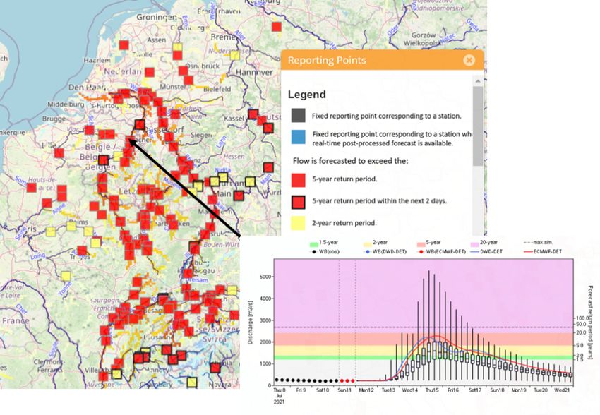
On 9 and 10 July, flood forecasts by the European Flood Awareness System (EFAS) of the Copernicus
Emergency Management Service indicated a high probability of flooding for the Rhine River basin,
affecting Switzerland and Germany. Subsequent forecasts also indicated a high risk of flooding for the
Meuse River basin, affecting Belgium. The magnitude of the floods forecasted for the Rhine River basin
increased significantly in this period. The first EFAS notifications were sent to the relevant national
authorities starting on 10 July and, with the continuously updated forecasts, more than 25 notifications
were sent for specific regions of the Rhine and Meuse River basins in the following days until 14 July.
Figure: EFAS flood forecast from 12.07.2021 00:00 UTC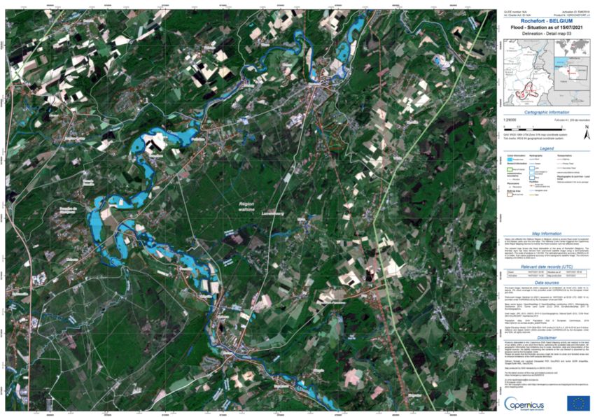
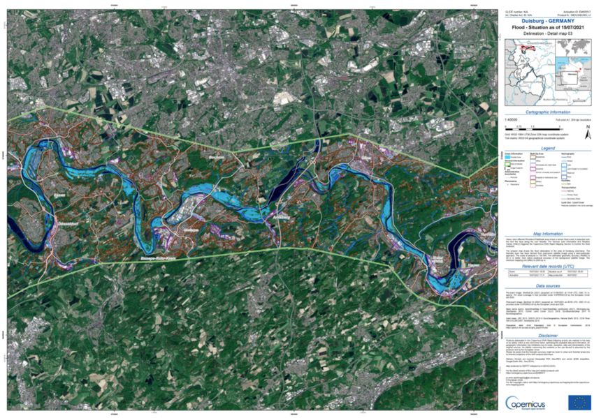
Providing early and current maps of flooded areas
On 13 July, the CEMS Rapid Mapping component was activated to map the ongoing floods in parts of
Western Germany (EMSR517 Mapping Website , EMSR517 Activation Viewer). As a flood peak was
foreseen on 16 July for segments of other rivers, CEMS preemptively acquired satellite images of the
vulnerable area through Pre-Tasking on 14 July. These early images informed ensuing activations by the
CEMS Rapid Mapping component based on the EFAS forecasts for areas in Belgium, Netherlands,
Germany, Switzerland and France.

In Germany, the extension of the floods in six areas is currently being analysed in the south-east of the
country: Moselle, Ahr, Pruem and Kyll rivers. The German authorised user has asked CEMS to monitor
other towns and rivers reported as already affected or at very high risk. These include the towns of Hagen,
Altena, Erkrath und Düsseldorf, and areas along the rivers Düssel/Nördliche Düssel, Rur, Erft, Agger and
Sieg.

A first flood map was produced on 14 July over the Rhine River, based on a satellite image acquired on
the same day, but in which no impact of flooding was detected. Additional products were delivered on 16
July (based on a satellite image acquired on the 15th) showing substantial flooding. Monitoring products
will follow up on the 16th. Increased areal visibility from weather conditions will allow acquisitions of
optical imagery to be attempted for the 17th. These images will be used to perform a damage assessment.

Flood delineation map in Duisburg, Germany [EMSR517 Duisburg Delineation Map – Overview map 01]
(Copernicus EMS © 2021 EU)

Monitoring worsening floods in Belgium
The Belgian authorities requested the activation of the CEMS Rapid Mapping Component on the 14th July
to map the ongoing floods (EMSR518 Mapping Website , EMSR518 Activation Viewer).

In Belgium, they are around the towns of Liège and Rochefort (north-east of the country) are being
monitored. CEMS flood delineation products were delivered on 15 and 16 July, showing the extent and
location of the flooding along the Meuse River. 1583ha (15.83 km2) of flooded area was detected on the
satellite image (acquired on the 15th of July), located mostly in the surroundings of the towns of
Maastricht, Maaseik, Rochefort and Durbuy. Monitoring products will follow up on the 16th. Considering
the improvement of the weather, optical acquisitions will be attempted on the 17th in order to produce
damage assessments.

Flood delineation map in Rochefort, Belgium [EMSR518 Rochefort Delineation Map – Overview map 01]
(Copernicus EMS © 2021 EU)

Rapid Mapping activated for Floods in Switzerland
The Swiss authorities requested the activation of the Rapid Mapping on 15 July for the area around Bern,
following floods in the Aare River basin (EMSR519 Mapping Website , EMSR519 Activation Viewer)

The first map is expected to be delivered on 16 July.

Rapid Mapping activated for Floods in the Netherlands

The Dutch authorities requested the activation of the CEMS Rapid Mapping component on 16 July for the
area around and north of Maastricht to analyse the Meuse River basin (basin (EMSR520 Mapping Website
, EMSR520 Activation Viewer)

The first map is expected to be delivered on 16 or 17 July based on when the peak of the event is expected.

The maps and vector data are or will be available for viewing and download on the Copernicus EMS
Website:

    •   https://emergency.copernicus.eu/mapping/list-of-components/EMSR517
    •   https://emergency.copernicus.eu/mapping/list-of-components/EMSR518
    •   https://emergency.copernicus.eu/mapping/list-of-components/EMSR519
    •   https://emergency.copernicus.eu/mapping/list-of-components/EMSR520

For updates on our activations, follow Copernicus EMS on Twitter.

Learn more about the Copernicus programme and its Emergency Management Service online.

For more information contact
support@copernicus.eu
Follow our Twitter feed @CopernicusEMS where maps and vector data are posted automatically in near
real-time
BACKGROUND INFORMATION ON THE COPERNICUS EMERGENCY MANAGEMENT SERVICE (EMS)
The Copernicus Emergency Management Service (CEMS)1, one of the six Copernicus services, provides
information for emergency response in relation to different types of disasters, including meteorological
hazards, geophysical hazards, deliberate and accidental man-made disasters and other humanitarian
disasters, as well as prevention, preparedness, response and recovery activities. Beneficiary end users of
EMS include entities and organisations at regional, national, European and international level actors in
the field of civil protection and humanitarian aid. CEMS consists of two main components, as outlined
below:
1. The CEMS Mapping component provides, upon activation by Authorised Users2, timely and
accurate information derived from satellite or airborne image data, during all phases of the
disaster management cycle. The information generated can be used as provided (e.g. as digital or
printed map outputs), or further combined with other data sources (e.g. as digital feature sets in
a geographic information system) to support geospatial analysis and decision-making processes
by disaster managers. The following three modules are in place:
● Rapid Mapping consists of the provision of geospatial information in support of
emergency management activities immediately following a disaster. Different types of
maps are produced: the Reference product to ascertain the situation before the event,
the First Estimate product and the Delineation product to assess the geographical extent
of the event with respectively a rough or detailed assessment, or the Grading product to
evaluate the magnitude and impact of the damage resulting from the event.
● Risk & Recovery Mapping consists of the provision of geospatial information in support
of disaster management activities that are not related to immediate emergency response
but rather to pre-disaster risk assessment or post-disaster recovery monitoring. This
applies to activities dealing with prevention, preparedness, disaster risk reduction and
recovery phases.
● Validation is tailored to the on-demand verification of a sample of outputs produced by
the above two mapping modes, support services, and the early warning services (see
below). It includes external quality control, validation of thematic information content
and comparison with alternative information sources related to the specific emergency
context.
2. CEMS Early Warning and Monitoring component provides early warning, risk and impact
assessment, and monitoring of specific natural hazards. Currently this component addresses
floods, forest fires and droughts, as follows:
● The European and Global Flood Awareness Systems (EFAS & GloFAS) provide
complementary flood forecast information to relevant stakeholders supporting flood risk
1
https://emergency.copernicus.eu/
2
Authorised Users include the National Focal Points (NFPs) of the EU Member States and countries participating in
the Copernicus programme, as well as European Commission services and the European External Action Service
(EEAS), including the EU Delegations. Interested Users may trigger the service by sending a Service Request Form
(SRF) directly to the European Response Coordination Centre (ERCC): echo-ercc@ec.europa.eu.management at national, regional and global level. Registered Users have access to the
full functionality of EFAS & GloFAS.
● The European Forest Fire Information System (EFFIS) monitors forest fire activity in NRT,
in Europe, Middle East and North Africa, and supports wildfire management at national
and regional scales. Globally, the JRC leads development of the Global Wildfire
Information System (GWIS).
● The European and Global Drought Observatories (EDO & GDO) provide drought-relevant
information and early warnings for Europe and globally, publishing short analytical
reports in the case of imminent droughts, and connecting drought data providers and
users from global to regional levels.
The Copernicus programme
Copernicus, the European Earth Observation and Monitoring Programme, is served by dedicated satellites
(the family of Copernicus Sentinels) and a set of Contributing Missions (additional satellites from existing
commercial and national agencies). Since the launch of Sentinel-1A in 2014, the European Union set in
motion a process to place a constellation of almost 20 more satellites in orbit before 2030. Today, seven
fully operational Sentinel satellites (Sentinel-1A and -B, Sentinel-2A and -B, Sentinel-3A and -B and
Sentinel-5P) are in orbit to continually provide operational satellite information. This satellite data is
complemented by and validated with in situ data.
Six Copernicus Services transform the full, free and open data into value-added information by processing
and analysing the data to transform them into services and products such as informative maps, data sets
and reports.
These six services are:
● The Copernicus Atmosphere Monitoring Service
● The Copernicus Marine Environment Monitoring Service
● The Copernicus Land Monitoring Service
● The Copernicus Climate Change Service
● The Copernicus Emergency Management Service
● The Copernicus Security Service
Copernicus is coordinated and managed by DG GROW in the European Commission. It is implemented in
partnership with the EU Member States, the European Space Agency (ESA), the European Organisation
for the Exploitation of Meteorological Satellites (EUMETSAT), the European Centre for Medium-Range
Weather Forecasts (ECMWF), EU Agencies and Mercator Ocean. The European Commission Joint Research
Centre offers the technical support of the Copernicus Emergency Management Service whilst the
Emergency Response Coordination Centre of DG ECHO assists civil protection actors with the handling of
the EMS mapping requests on a 24/7 basis.
For more information
Copernicus website: copernicus.eu
Copernicus Emergency Management Service website: emergency.copernicus.euOn Twitter @CopernicusEMS
You can also read