Farm Emergency Planning for Extreme Heat, Wildfires and Smoke - July 8, 2021
←
→
Page content transcription
If your browser does not render page correctly, please read the page content below
Far m Emergency
Planning for Extreme
 Heat, Wildfires and
       Smoke
        July 8, 2021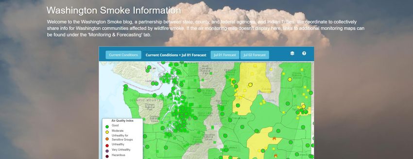
RESULTS OF HEAT MAPPING
PROJECT SHOW INEQUITABLE
IMPACT OF HOTTER SUMMERS, WILL
INFORM ACTIONS BY KING COUNTY
AND CITY OF SEATTLE

        Applying data to reduce heat impacts

                     https://kingcounty.gov/elected/executive/constantine/news
                     /release/2021/June/23-heat-mapping-results.aspx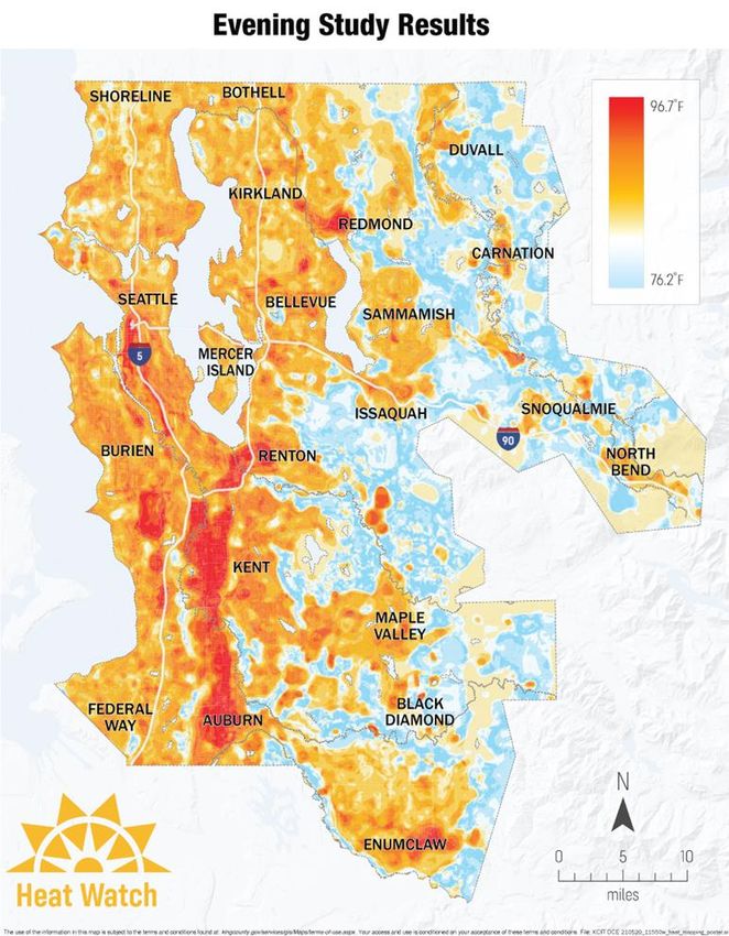
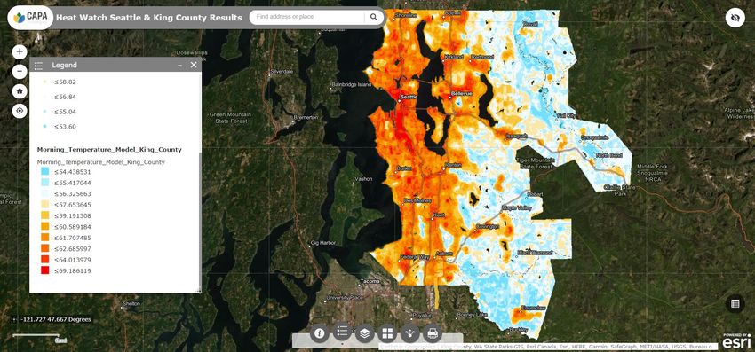
King County and City of Seattle today
announced the results of a
groundbreaking heat mapping project
that quantifies the harmful, inequitable
impact that hotter summers are having
on the region. The data show that
surface-level temperatures in areas
with paved landscapes, less tree
canopy, and industrial activity are
substantially higher during summer
heat events compared to less
urbanized areas.

 Heat is evenly distributed during the afternoon
Volunteers helped King County
     and City of Seattle record more
     than 110,000 temperature
     measurements at three different
     times of the day during a one-
     day extreme heat event in July
     2020. Temperature data were
     collected at one-second intervals
     while driving designated routes
     in different locations around the
     county.

Areas with more natural landscapes retain less heat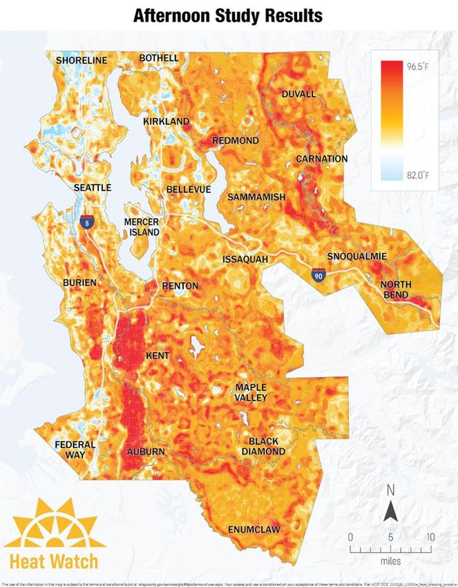
Farm Emergency Planning for
       WILDFIRES AND SMOKE

Plan          Monitor            Monitor   Recovery
             Situation            Farm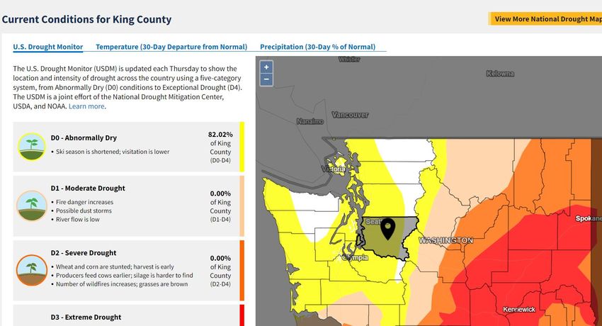
The Seattle Times

Pacific                                   3 of Seattle’s 4 hottest days on
                                          record just happened
Northwest’s                               June 29, 2021 at 4:17
                                          pm Updated June 29, 2021 at
record-smashing                           5:00 pm
heat wave
                                       Pacific Northwest heat wave ‘tip of the melting...
primes wildfire,                        In an interview with The Seattle Times, Gov. Jay
                                            Inslee said this month's record-breaking
buckles roads;                                        heat... New 4:20 pm

health toll not
yet known                     Seattle’s biggest difference between one day’s high
June 28, 2021 at 7:11         temperature and the next day’s low temperature is 43 degrees,
pm Updated June 29, 2021 at   according to Joe Boomgard-Zagrodnik, a postdoctoral
9:37 am                       researcher in agricultural meteorology at Washington State
                              University.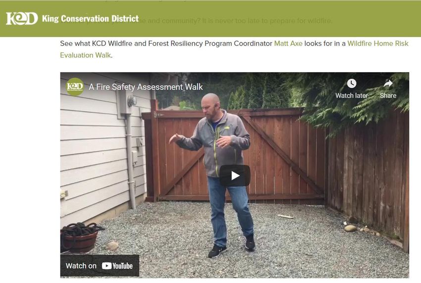
Farm Emergency Planning
          KEY INDICATORS TO
          MONITOR SITUATION

Drought      Smoke/Air         Local Burn   Observation
              Quality            Bans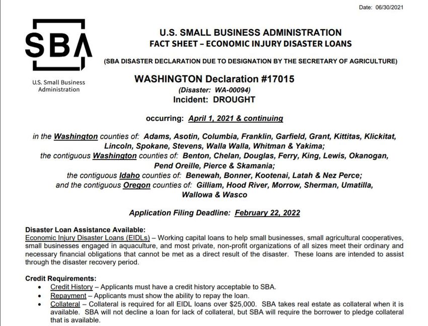
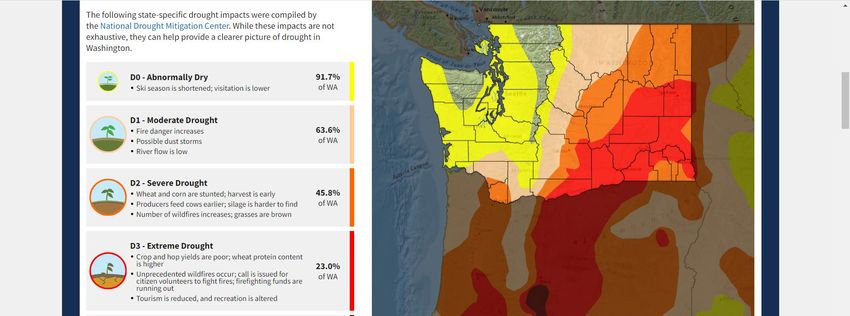
• 76.5 Million acres of
  crops in U.S. are
  experiencing drought
  conditions this week.
• 27.7% since last week
• 27.7% since last
  month

HTTPS://WWW.DR
OUGHT.GOV/STAT   Current U.S. Drought Monitor Conditions for
ES/WASHINGTON    Washington
HTTPS://WWW.DR
OUGHT.GOV/STAT
ES/WASHINGTON/   Current U.S. Drought Monitor Conditions for King County
COUNTY/KING
Find your location:
https://www.arcgis.com/apps/webappviewer/index.html?id=84709c65c08a40bbb47d0723ef1c797a&extent=-
13604644.7965%2C6019787.1095%2C-13561266.7829%2C6046616.5065%2C102100
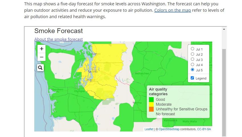
WILDFIRE SMOKE   Air Monitoring Map:
                 https://wasmoke.blogspot.com/
Smoke Forecast Map:
WILDFIRE SMOKE
https://ecology.wa.gov/Ai
r-Climate/Air-
quality/Smoke-
fire/Wildfire#colorsBurn ban in effect
Fire safety burn bans are issued by King
County Fire Marshal due to fire danger
during dry weather conditions and there is
low moisture in trees and vegetation.
https://kingcounty.gov/de
KING COUNTY pts/local-
services/permits/fire-
FIRE MARSHAL safety/burn-bans-
fireworks.aspxFarm Emergency Planning
PLANNING AND
RECOVERY RESOURCES
Livestock Livestock Emergency Livestock Evac
and Triage Emergency Loans and Locations
Planning Crop
Insurancehttps://wildfires.wsu.edu/agriculture-and-forest-landowners/
Livestock injury
assessment and health
•Wildfires, Smoke, and Livestock

•Assessing Burns in Livestock

•Animal Triage Procedures

•Fire Retardant Impacts on Livestock
AVMA:
                                         • Livestock natural disaster planning and checklists
                                         • Livestock identification
                                         • Equine and livestock evacuation kit
                                        • Evacuating backyard poultry
                                        • Backyard poultry evacuation kit

                                        • Keep a list of the species, number and locations of
                                        your animals near your evacuation supplies and note
                                        animals’ favorite hiding spots. This will save precious
                                        rescue time.

                                        •    Some items in the evac kit
                                         •    7-10 day supply of feed, supplements, and water
                                         •    Bandanas (to use as blindfolds)
                                         •    Batteries (flashlight, radio)
                                         •    Blankets
 https://www.avma.org/resources/pet-    • Copies of veterinary records and proof of
owners/emergencycare/large-animals-       ownership
                                        • Cotton halter
              and-livestock-disasters
                                        • Duct tape
Tips to protect livestock
SMOKE symptoms
in animals • Limit exercise when smoke is visible. Especially don’t
If any of your animals are require animals to perform activities that substantively
experiencing any of these signs, increase airflow into and out of the lungs.
please consult your veterinarian.
• Provide plenty of fresh water near feeding areas.
Coughing or gagging • Limit dust exposure by feeding low-dust or dust-free
Difficulty breathing, including open
feeds and sprinkling or misting the livestock holding area.
mouth breathing and increased • Plan to give livestock 4 to 6 weeks to recuperate after
noise when breathing the air quality returns to normal. Attempting to handle,
Eye irritation and excessive watering move, or transport livestock may delay healing and
compromise your animals’ performance.
Inflammation of throat or mouth
• Have a livestock evacuation plan ready in advance. If you
Nasal discharge don't have enough trailers to quickly transport all of your
animals, contact neighbors, local haulers, farmers,
Asthma-like symptoms producers, or other transportation providers to establish a
Increased breathing rate
network of reliable resources that can provide
transportation in the event you need to evacuate your
Fatigue or weakness animals.
Disorientation or stumbling
• Good barn and field maintenance can reduce fire danger
for horses and other livestock. Make sure barns and other
Reduced appetite and/or thirst structures are stable, promptly remove dead trees, clear
away brush, and maintain a defensible space around
structures.USDA CROP AND LIVESTOCK
INSURANCE
Risk Management Agency
Whole-Farm Revenue Protection (WFRP)
Insurance coverage against the loss of revenue that you expect to earn during the insurance period under one
insurance policy.
• Designed for small, diversified farms that sell direct or wholesale;
• Based on your own production and sales;
• Federally subsidized means lower premium cost to farmers
• A range of coverage levels from 50-85 percent to fit the needs of more farming and ranching operations;
• Replant coverage for annual crops, except Industrial Hemp;
• The ability to consider market readiness costs as part of the insured revenue and expenses;
• Provisions to adjust the insurance guarantee to better fit expanding operations;
• An improved timeline for farming operations that operate as fiscal year filers; and
• Streamlined underwriting procedures based on the forms used for WFRP.USDA CROP AND LIVESTOCK
INSURANCE
Farm Service Agency
Disaster Assistance Programs
• Livestock Forage Program
• Livestock Indemnity Program
• Emergency Assistance for Livestock, Honeybees, and Farm-Raised Fish
• Tree Assistance Program (orchards, bushes, vines)
• 2017 Wildfires and Hurricanes Indemnity Program
Loans for losses to crops, trees, livestock, farmland and farm property
Emergency Loan Program
Disaster Set-Aside Program
Emergency Conservation Program (ECP)
Crop Losses
Noninsured Disaster Assistance Program (NAP) *DROUGHT DECLARED IN WA
By USDA; USDA FSA and US SBA loans being made available
Farm Service Agency
U.S. DEPARTMENT OF AGRICULTURE
When a tornado, flood, or drought strikes, or
a quarantine is imposed by the Secretary of
Agriculture, or when other natural disasters
occur, FSA's Emergency loan program is
there to help eligible farmers and ranchers
rebuild and recover from sustained losses.
Governor must also declare disaster.
Meanwhile
Farmers: jot down temps and losses as they
happen on a calendar.LIVESTOCK SHELTER LOCATIONS
If you have to evacuate or seek shelter for animals
Snohomish County’s Natural Disaster
King County’s Natural Disaster Emergency
Emergency Livestock Facility is the
Enumclaw
Livestock Facility is the
Evergreen State
Expo & Event Center Fairgrounds, MonroeFarm Emergency Planning for
WILDFIRES AND SMOKE
Questions?
Plan Monitor Monitor Recovery
Situation FarmSMOKE PREPAREDNESS FOR
PEOPLE
Addison Houston, Environmental Health Mitigation & Response Planner, Public Health – Seattle & King CountyFIRE RISK EVALUATION OF BUILDINGS
Matthew Axe, Wildfire and Forest Resiliency Coordinator, KCDYou can also read