Friends of Cypress Provincial Park Society - Friends of Cypress Provincial ...
←
→
Page content transcription
If your browser does not render page correctly, please read the page content below
Friends of Cypress Provincial Park Society
                                      P.O. Box 91053, West Vancouver, B.C. V7V 3N3
                                                   www.cypresspark.ca

                                Summer/Fall 2020 Newsletter

        Copperbush gleaming                                                              Lakes serene
                                                Dogwood blooming

The natural features of the park paid no attention to COVID 19, the pandemic of our time. Snow melted on the
trails, lakes became free of ice, plants started to bloom. Increasingly, many of us sought our provincial parks,
Cypress among them, as the places to walk and hike and climb, and yes, to reflect on our good fortune to live in a
city with ease of access to beautiful parks and outdoor spaces. And then, on April 8, BC Parks announced that
Provincial Parks were closing due to COVID-19. Negative reaction was swift as we know, not least because other
local parks were quickly overwhelmed by seekers of outdoor recreation recommended by Dr Bonnie Henry, BC’s
esteemed Public Health Officer. After consideration BC Parks announced a reopening of 7 Parks, Cypress
Provincial Park among them, with a Day-Use Park Reservation System.

Day-Use Pass Reservation System
The Day Pass System was a three-month Pilot Project that ended at Cypress on September 28. It is not clear
how this ‘Pilot Project’ collected feedback to assess data or how successful it was - or whether it was an
expensive exercise in futility that BC Parks staff were ordered to carry out. The cost to BC Parks was a reported
$800,000. Many trail users commented that they wished the money could have been spent on trail work, work that
is delayed every year due to lack of funds and available crew. Rather than applying for a day pass, many hikers
chose to go to other areas where passes were not required, such as the Squamish River Valley, which this year
was badly overcrowded and where there were numerous calls to Squamish Search and Rescue to assist lost and
injured hikers. Moreover, many people found ways around the system, and some trailheads were signed
indicating that a Day-Use Pass was required, but the access was not monitored at the trail head or anywhere
along the trail.
One peculiar and potentially dangerous situation was the Day Pass signage for Hollyburn Mountain directing
hikers to take the overgrown Hollyburn Hikers Winter Access trail to Hollyburn. The winter access trail is generally
not used in summer as it is a known area for bears to feed in late summer. Fortunately the majority of hikers used
the main trail up to Hollyburn instead. Moreover, no-one was at the day-pass signed Hollyburn trail to check day
passes, similar to the situation at other trailheads at Cypress at different times during the day. We are doubtful
that any meaningful data will have been collected for this ‘Pilot Project’.

BC Parks News
Congratulations to Elyse Curley who has been appointed Acting Area Supervisor for BC Parks South Coast
Region, replacing Scott Donker who had held the position since 2018. Scott has returned to the north of the
province with his young family.
Elyse has a background in Environmental Science. She has most recently held the position of BC Parks
Community Liaison Officer, working on community engagement in Sea to Sky, Sunshine Coast and Lower
Mainland Provincial Parks. Simon Debisschop is Senior Ranger. Gareth Wheatley has been appointed to a
temporary Senior Ranger position replacing Erin Rutherford. Erin is working as Conservation Coordinator with

                                                         1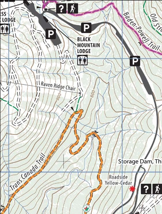
Joanna Hirner from June to early November. Auxiliary Rangers Sarah Town and Steve Donaghey have summer
positions with BC Parks. Both are highly qualified and keen. They have each worked with North Vancouver Parks
and Recreation, but want to be out on the trails. As we know, the South Coast region embraces a large area:
Cypress, Seymour, Pinecone Burke, Peace Arch and the marine parks of Hacklett Bay on Gambier Island and
Plumper Cove on Keats. We very much appreciate the work done by our rangers given the territory they have to
cover, including of course Cypress Park.
Cypress Invasive Plant Management Strategy
BC Parks Conservation Specialist Joanna Hirner has reported that invasive plant work, undertaken by Eco-
Ecological, will be similar to last year. They have engaged in reed canary grass inventory and removal, starting in
early July. Focus again has been on trailheads, trails and sensitive riparian areas leading from downhill and
Nordic ski areas. The work will include some additional treatment of larger patches with burial in cardboard and
mulch which seems to work well.
Monitoring and treatment of knotweed and giant hogweed is being undertaken by Invasive Species Council of
Metro Vancouver.
Cypress Mountain Resort Update—from Russell Chamberlain CEO
Here is a snapshot of some of the things you can expect when you arrive this winter:
• New auto flush toilets and touchless sinks in Cypress Creek Lodge and Hollyburn Lodge
• Additional convenient hand washing and sanitizing stations throughout the Resort
• An upgrade of Ecommerce to support online purchases
• New covered outdoor dining facilities
• Upgraded Cypress Creek Lodge ventilation and air filtering system
The above upgrades do not apply to Black Mountain Lodge. Black Mountain Lodge is heavily used in the winter
by backcountry snowshoers and hikers. As backcountry users do not have access to the facilities at Cypress
Creek Lodge, FCPP will be alert to maintenance issues of the facilities in Black Mountain Lodge. Maintenance of
Black Mountain Lodge is the responsibility of the resort.
Not reported in the update above
New Mountain Coaster ride to debut at Cypress Resort in 2021
FCPP reported previously on a Four Season Development Proposal put forward by Cypress Resort. No further
information had been forthcoming. The new Mountain Coaster Ride seems like a first step. We will be addressing
concerns and discussing with our membership.
Trail Watch and Trail Watch Workers
Anne Leathem has coordinated the Trail Watch program for many years. Challenges for the coordinator and trail
watchers multiplied in this year of COVID. Access to many of the trails required passes. Trail Watchers and
Rangers missed the opportunity to meet and greet at the Trail Watch Safety and Training Meeting which was
cancelled. Anne Leathem circulated the government forms for provincial insurance coverage to trail watch
volunteers, collected them and returned to parks by email. Trail watchers were then ready to tread their trails to
pick up garbage; take note of winter trail damage; to take note of aging trail ropes and signs; and of course to
enjoy the special features of the trails they are assigned to.
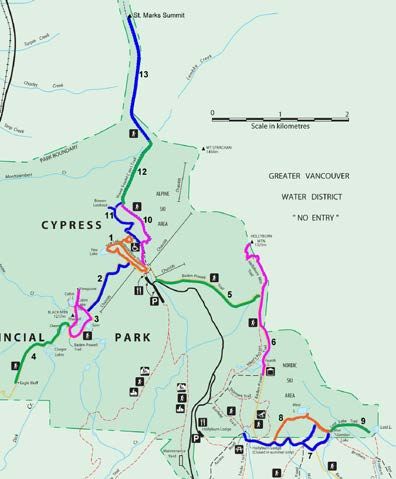
On the map below you will see that the trails are identified by Number. Trail#1 is the Yew Lake and Ancient Forest
Loop and the Trail Watch worker is Gail Ross. Trail#2 Black Mountain Trail to Cabin Lake is assigned to Cypress
Park Facility Operators. (This assignment is a legacy of the Olympics when the old trail to Cabin Lake and Black
Mountain was impacted by the construction of ski runs for the 2010 Olympics, bid for by the Resort. As
recompense Cypress Mountain built the current trail and has accepted a duty to maintain). Trail#3 Black Mt Loop
is Sylvia Mather; Trail#4 Eagle Bluff is Anne Leathem; Trail#5 is Marshall Bauman and Smita Patel; Trail#6
Hollyburn Peak is Alex Wallace;Trail#7 Blue Gentian Lake is Lyn Grants and Carol Ensor; Trail# 8 West Lake is
Anne George ; Trail#9 Lost Lake is Paul Berlinguette and Fiona Wright; Trail #10, 11, 12 Howe Sound Crest Trail
is Paul Geddes and Ron Ash; Trail#12, 13 Howe Sound Crest Trail is Bill Kinkaid and Daphne Nagorsen.
2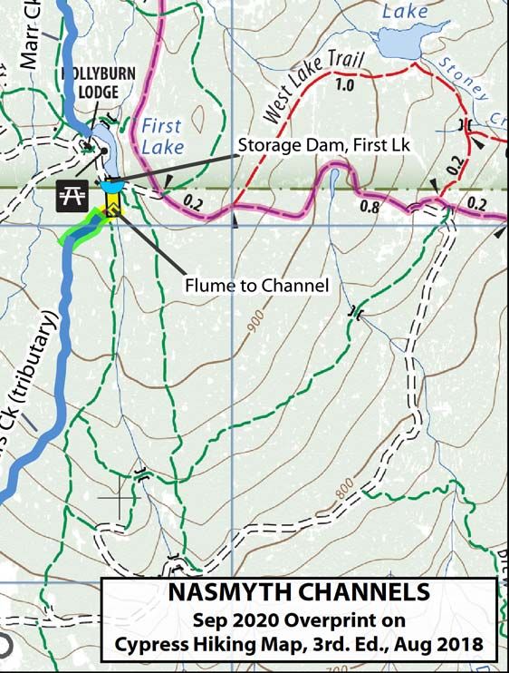
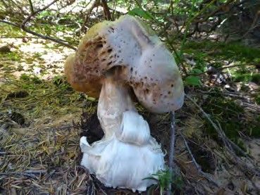
A typical trail watch day or half day could involve excited observation
                                                of plants and fungi,
                                                grubbing out of ditches
                                                to assist water run-off,
                                                clipping back of
                                                vegetation, and, sadly,
                                                the collection of
                                                miscellaneous garbage!

Trail Work
Black Mountain Plateau to Eagle Bluff: The upgrading of the very popular Baden Powell trail on Black Mountain
and through to Eagle Bluff has been underway, in a somewhat stop and go manner, since 2012.
Unfortunately, due to BC Parks staff being taken up for some months developing the Day Pass system and
related signage, no bids went out this year until late in the season, and it’s not clear if the crew can get there this
Fall. We are hoping that BC Parks will be able to get boards and other materials helicoptered up to Black
Mountain Plateau for crew to continue trail work in 2021.

Howe Sound Crest Trail: As far as we know this project has also been the victim of the Day Pass system. No
further trail work has been undertaken this season. Roughly 100m of trail went ahead in 2019, with the assistance
of $20,000 in funds from FCPP.

Lost Lake Trail: Paul and Fiona, Trail Watchers for this trail, finished clearing a new trail avoiding fallen logs, just
before Brothers Creek Canyon, while on their initial hike along the trail at the beginning of the year. Traffic on this
trail has increased significantly and the wet spring weather contributed to trail degradation. They are hoping to
work with BC Park rangers on another bog bridge over the western section of this trail this fall.

Blue Gentian Lake: Paul and Fiona had noticed a number of areas on the Gentian Lake trail that needed work
and were able to coordinate with BC Park rangers to undertake some work there this summer. On Saturday
August 15 two Rangers, Sarah Town and Steve Donaghey, picked up wood donated by Paul and drove the wood
to the site of the old West lake Lodge. Anne Leathem, Trail Watch Co-ordinator and Gentian Lake Trail Watchers
Carol Ensor and Lyn Grants were also there for part of the morning to lend a
                                         hand (or two). They carried the wood
                                         down to the Blue Gentian trail leaving
                                         it near the junction with the Baden
                                         Powell Trail to build board walks the
                                         Blue Gentian Lake Trail. Gareth
                                         worked with the chainsaw to build the
                                         yellow bog bridge he is standing on,
                                         as well as base logs to rebuild a
                                         broken boardwalk over another
                                         muddy section of the trail. Paul
                                         completed 2 more sections of
boardwalk over areas that become extremely muddy during the wet season.
Steve then worked with Gareth, while Fiona stashed the remainder of the
wood for future repairs. Encouraging to have some trail work done. Thank
you to FCPP members Paul and Fiona and, of course, to the Rangers.

                                                           3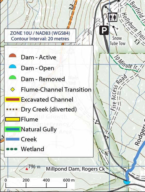
And now- to some miscellaneous items of interest

Red Bumps on Alder Leaves
An enquiry from the website was forwarded to Alex Wallace, President, about red
bumps on alder leaves near Bowen Lookout. Alex researched the topic: “I found it
was more interesting that I would have expected. Here’s my horticultural reply”:
These sound like leaf galls resulting from the presence of tiny gall moths (distantly
related to ticks), which affect leaves on different trees but don’t generally harm them,
unless it’s a heavy infestation. Some people are annoyed by the bumps and spray
their trees for mites. There is an interesting article on this topic in Wikipedia:
ERIOPHYES inangulis

From Gall Moths to Looper Moths
We have all read enough, heard enough, experienced enough about looper moths and will continue to experience
the flutter and persistence of the looper moths for some time. But why the name Looper? The term is descriptive
of the way the crawling larva of the moth draws the rear of its body up to its front legs, forming a loop and then
extends its body again.
Earlier in the season, returning from a walk in the forest or along
the street under trees, it was not unusual to find an “inch-worm”
or a “looper" in one's hair, or on one’s clothing. One had to
wonder into what they would turn! Now we know - into a plague of
loopers, the name of the larvae now assigned to the moth.
The particular looper moth fluttering against our window, entering
the house with us, particularly prevalent on the North Shore, is
the Lambdina fiscellaria. The scientific name for this family of
moths is Geometer from the Ancient Greek geo for "the earth”,
and metron for “measure" in reference to the way their larvae,
looper or inchworm, appear to "measure the earth" as they move along in a looping fashion. Nature is never
boring!

FCPP New Website
FCPP has been working on a new website which can be found at cypresspark.ca or simply by searching Friends
of Cypress Provincial Park.
The site is far from complete. We will upload many photos and additional information. Our aim is to have a
website that can be easily updated by adding our newsletters, hiking events, and other news. Our popular hiking
map has been digitalized and is available on the website. Other options for downloading will be added later.
Although not yet in its final version we welcome you to view the website and to make suggestions.

Friends and Neighbours - Friends of Cypress Provincial Park and Old Growth Conservancy Society
The Friends of Cypress Provincial Park Society and the Old Growth Conservancy Society have always had a
close relationship. They have shared members, directors and founders - and some of the same threats. For a
long time they also shared meeting space and tea. ‘Meeting space’- what a concept! Remember those days?
(Sorry, I’m tearing up). We used to joke about ‘staying over’, as the other society was meeting at the same place
the next day - but I digress!
There is one problem not shared, however - ‘crowd control’. While BC Parks has been implementing crowd
reduction strategies, the Old Growth Conservancy remains as tranquil as ever - and, of course, we like it that way.
On Labour Day I walked with Smita from parking Lot 5 on easy soft trails to a picnic view site south of the
Conservancy, and then on to the Trans Canada Trail - and back. An hour and a half in all - and never saw a soul -
on a sunny holiday. It’s lonely out there!
Seriously though, for a new hiking experience, the West Vancouver trails south of the Old Growth Conservancy
are waiting to be explored - ideal terrain for our ‘social distancing’ situation. Good luck finding anyone to stay
6ft away from. And in my experience, the bikers who do know about these trails are completely friendly - and
rarely encountered.
Email me at foxhole@telus.net for more information……. Marshall Bauman

And now to our Feature Article for the Summer/Fall Newsletter . . .

                                                          4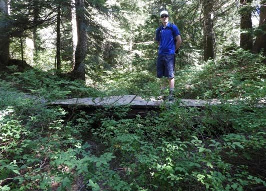
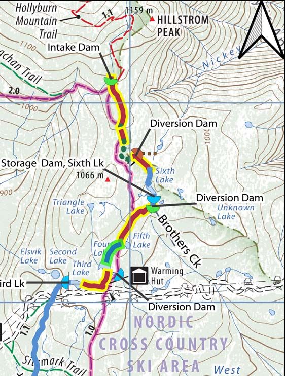
Exploring the Nasmyth Channels on Hollyburn.
Mike Castle

What are the Nasmyth Channels? In 1918 James Nasmyth started a logging operation on Hollyburn. A shingle
bolt mill was built adjacent to Rodgers Creek, at what is now the last bend on Cypress Bowl Road, just below the
Cabin Area parking. The remains of the millpond dam can still be seen. The Nasmyth mill was shut down in 1923.
To augment the water supply to the mill, water was diverted from the upper reaches of a Cypress Creek tributary,
below Hillstrom Peak, and from Brothers Creek. Using existing gullies and wetlands, a series of channels was
excavated to link these natural features and divert water toward Rodgers Creek via Sixth, Fourth, Third and First
lakes.

I started mapping in the Park in 2010, with a GPS, to collect data for the Summer Hiking Map and by 2013 the
first edition of the Hiking Map was launched. I discovered that the Provincial TRIM data for contours, creeks was
- shall we say - not entirely reliable. As a result, there were several creeks that were missing, flowing “uphill” or
into the wrong watershed. This led to re-mapping of many creeks and heights of land, which then progressed into
a search for the Nasmyth Channels.

On a hike down Main Trail, near Hollyburn Lodge, I came across a small bridge 100 m south of First Lake

                                                                  This bridge is on a height of land, and there is a
                                                                  dry channel below it. Marr Creek is below to the
                                                                  east, and to the west is a dry gully that slopes
                                                                  down in the general direction of Rogers Creek.
                                                                  This channel, under the bridge, was part of the
                                                                  Nasmyth Channel system.

                                                                  From the First Lake Dam, water ran through a
                                                                  flume to this excavated channel. The top of the
                                                                  flume was just to the east of the Nasmyth Bridge,
                                                                  where there is now a steel “Binwall” in place of
                                                                  the original flume. If you stand there and look
                                                                  downstream – across the creek - the line of the
                                                                  flume is still visible as a clearing through the
                                                                  trees, which is more obvious in winter.
Bridge on Main Trail

The next job was to find out how the water got down to the
mill. Marshall Bauman also likes bushwhacking, and in 2016
we explored the area between Main Trail and the Nasmyth
Mill site. This confirmed that the channel led to the top of a
creek which joins Rogers Creek just upstream of the Nasmyth
mill pond. This creek now runs in a culvert under Cypress
Bowl Road.

Alex Wallace had told me about the channels that can be
found further up Hollyburn Ridge. So, in 2017, it was
arranged with Alex that he would provide a guided tour.

We arranged two expeditions, in July and October 2017, with
several FCPP members in tow.
                                                                  Remains of Nasmyth millpond dam

                                                          5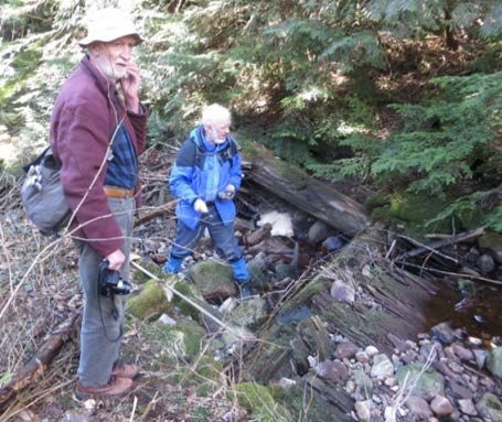
We were able to follow the whole channel system from Marr Creek and Third Lake up to the intake channel. The
intake dam was located on a tributary of Cypress Creek, about 70 m north of the junction of the Hollyburn
Mountain Trail and Baden-Powell Trail. There is no trace of the intake dam, but the intake channel (now dry) is
still visible.

Where the channel reaches the open area at the Romstad ski run, the water would have then run through various
natural gullies toward the Capilano watershed. But a second diversion dam, located 200 m north of Sixth Lake –
sends the water back over the divide, via Sixth Lake, into Brothers Creek.

This diversion dam is an earthfill structure and is still in place. It diverts the water into an excavated channel to
discharge into Sixth Lake. This active section of channel still operates as a “creek” today. It defines the Capilano
watershed, and there are some old “Watershed” signs on trees to the east of the channel. This also defines the
Park Boundary – as shown on the Hiking Map.

There is a storage dam on Sixth Lake which I only really noticed this summer. This is what keeps me interested,
as there is always some else to find. If you hike along the Unknown Lake snowshoe trail, at the south end of Sixth
Lake, look for a small wooden box culvert at the outlet of the lake. You can still see the saw marks on the lumber.
This is, most likely, an original Nasmyth artefact.

South of Sixth Lake another diversion sent the water west again, from Brothers Creek back over towards Fourth
Lake, bypassing Fifth Lake. If you are hiking near Fifth Lake, you can see part of the channel system right beside
the trail.

Just above the Warming hut, at the outlet of Fourth Lake, the B-P trail runs along the crest of the old diversion
dam with a bridge over the breached section. Another excavated channel (now blocked) allowed water to flow
through the trees from Fourth Lake to Third Lake, where another storage dam controlled the flow into Marr Creek
and on to First Lake.

If you would like to know more about the James Nasmyth logging operation, the new FCPP website has a more
detailed description. Go to cypresspark.ca/park-history and scroll down to “1918-23”.

A map of the channels is on the following page. It is overprinted on the Summer Hiking Map and shows the
results of the channel exploration.

Bushwhacking along the channels, creeks and gullies, offered a very different view of Cypress from the one you
get on the trails. For creek mapping, winter expeditions are much easier. Trying to figure the way things worked
gave an interesting insight into how Nasmyth used the topography to his best advantage.

A big thank you to my fellow explorers who made sure I did not get into too much trouble.

Renewing Your Membership for 2021
Your $10.00 membership is for one year. Membership dues are most frequently collected at FCPP AGM, this year
delayed until October 19. Information about our virtual AGM - Agenda and attached Documents will be
forthcoming.

To renew your membership NOW please use the membership form on the “Join Us” page of the website.
Your support is greatly appreciated.

                                                          6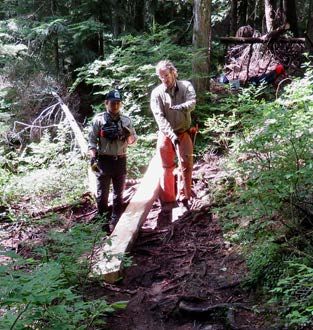
5,468,000   5,469,000   5,470,000   5,471,000

485,000
                                                          485,000

486,000
                                                          486,000

487,000
                                                          487,000

          5,468,000   5,469,000   5,470,000   5,471,000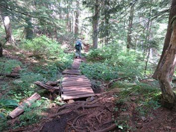
You can also read