5 Million OZ GOLD EQUIVALENT - Benchmark Metals Inc.
←
→
Page content transcription
If your browser does not render page correctly, please read the page content below
5 Million OZ

                         Targeting
                                     GOLD EQUIVALENT
                                       MINERALIZED DOMAINS USED FOR EXPLORATION TARGET, MINERAL
                                        INVENTORY AND MODELLED PIT SHELLS ON GROUND MAGNETICS

                                                                                                                  Mine Portal
                                                                                                  AGB

                                                               Mine Portal

                                           DUKE’S
                                            RIDGE

                                                                PHOENIX
                                                                     PHOENIX EAST

                                                                                                                           100% Owned
                                                                                                                        GOLD SILVER PROJECT

                                                                                                  TSX/V : BNCH
                                                                        June 2020                 OTCQB : CYRTF
TECHNICAL PRESENTATION                                                                            WKN : A2JM2X
Disclaimer

Forward Looking Statements:
Certain statements and/or graphics in the Company’s press releases, web site information and corporate displays, among others, constitute “forward-looking statements”. These statements are based on information
currently available to the Company and the Company provides no assurance that actual results will meet management’s expectations. Forward-looking statements include estimates and statements that describe the
Company’s future plans, objectives or goals, including words to the effect that the Company or management expects a stated condition or result to occur. Forward-looking statements may be identified by terms such as
“believes”, “anticipates”, “expects”, “estimates”, “may”, “could”, “would”, “will”, or “plan”, or their conditional or future forms. Since forward-looking statements are based on assumptions and address future events and
conditions, by their very nature they involve inherentrisks and uncertainties.

Actual results relating to, among other things, results of exploration, project development, reclamation and capital costs of the Company’s mineral properties, and the Company’s financial condition and prospects, could
differ materially from those currently anticipated in such statements for many reasons such as: changes in general economic conditions and conditions in the financial markets ; changes in demand and prices for minerals ;
litigation, legislative, environmental and other judicial, regulatory, political and competitive developments; technological and operational difficulties encountered in connection with the activities of the Company; and
other matters discussed in this presentation. This list is not exhaustive of the factors that may affect any of the Company’s forward-looking statements. These and other factors should be considered carefully and readers
should not place undue reliance on the Company’s forward-looking statements. The Company does not undertake to update any forward looking statement that may be made from time to time by the Company or on its
behalf, except if required to do so by applicable securities laws. You are cautioned not to place any undue reliance on any forward-looking statement.

Forward Looking Statements or Information Related to Exploration:
Relating to exploration, the identification of exploration targets and any implied future investigation of such targets on the basis of specific geological, geochemical and geophysical evidence or trends are future-looking
and subject to a variety of possible outcomes which may or may not include the discovery, or extension, or termination of mineralization. Further, areas around known mineralized intersections or surface showings may
be marked by wording such as “open”, “untested”, “possible extension” or “exploration potential” or by symbols such as “?”. Such wording or symbols should not be construed as a certainty that mineralization
continues or that the character of mineralization (e.g. grade or thickness) will remain consistent from a known and measured data point. The key risks related to exploration in general are that chances of identifying
economical reserves are extremely small.

The presentation contains historical exploration data that have not been verified by Benchmark Metals Inc. and may not be accurate or complete, and therefore the information should not be relied upon.

Michael Dufresne, M.Sc., P.Geol., P.Geo., an independent director of the Company, also serves as a Technical Advisor and is the Qualified Person, as defined by National Instrument 43-101, responsible for reviewing and
approving the technical content of all materials publicly disclosed by Benchmark,including the contents ofthis presentation.

 2        TSX/V : BNCH | OTCQB : CYRTF | WKN : A2JM2X
About Benchmark Metals Inc.

Benchmark Metals Inc. is a mineral exploration company focused on proving
and developing the substantial resource potential of the Lawyer’s Gold and
Silver project, located in the prolific Golden Horseshoe of northern British
Columbia, Canada.

                                                                                     LAWYERS
                                                                                     GOLD & SILVER
                                                                                     PROJECT
Benchmark is a member of the Metals Group of Companies, and is led by a
dynamic group of resource sector professionals with a long track record of
success in evaluating and advancing mining projects from exploration
through to production, attracting capital and overcoming adversity to deliver
                                                                                VANCOUVER
exceptional shareholder value

 3   TSX/V : BNCH | OTCQB : CYRTF | WKN : A2JM2X
Why Invest in Benchmark? - Rapidly advancing towards production scenarios

    2018                                                                           2020                                                                              2021
         Acquired the Project                                                                Expansion Drilling                                                                PEA
        Extensive data compilation and small work                                            Block modeling of numerous zones.                                                Results to substantiate a
        program to determine future scope and scale                                          Mineral Inventory Target.                                                        world-class gold-silver asset.
        of the project.                                                                      Pit shell modeling.                                                              Working towards mine
                                                                                             50,000 m expansion and definition drill program.                                 development & production
                                                                                             Additional new discovery potential.                                              scenarios

                                                    Inaugural Field Program                                                              Resource Estimate
                                                    Drilling provided bulk-tonnage potential and large gold-                             Targeting multi-million oz potential
                                                    silver mineralized zones from surface.                                               Advanced work programs to enable Economic &
                                                    Eric Sprott becomes major shareholder.                                               Engineering Studies.

                                             2019                                                                              2021                    WORLDS LARGEST HEDGE FUND SEES
                                                                                                                                                         GOLD RISING 30% TO US $2000
                                                                                                                                                Source: Bridgewater’s co-chief investment officer Greg Jensen

4     TSX/V : BNCH | OTCQB : CYRTF | WKN : A2JM2X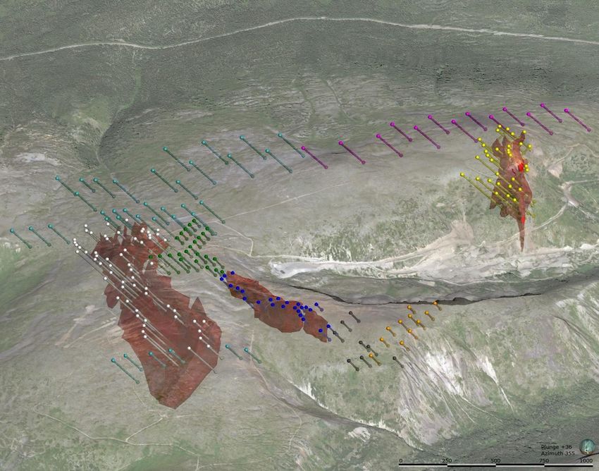
Located in British Columbia’s prolific ‘GOLDEN HORSESHOE’

Lawyers project is located within the northeastern region of the prolific metal-endowed Stikine terrane. Magmatic events in Stikinia during the Late Triassic and Early
Jurassic are the driving source for the development of mineralizing porphyry and epithermal systems. On both the east and west sides of the Bowser Basin the same
magmatic and mineralizing events are recognized, forming an arch of gold and polymetallic mineralization; known herein as the ‘Golden Horseshoe’

5    TSX/V : BNCH | OTCQB : CYRTF | WKN : A2JM2X
The Lawyer’s Project

                                                   Mine Portal

                                                                 Tailings   Fast Track To Production
                                                                 Facility   Historic past producer of
                                                                            171,000 oz gold & 3.7 million oz
                                                                            silver*
                                                    Extensive               Proven & profitable mining
                                                      Road
                                                    Network
                                                                            jurisdiction
    Mine Portal                                                             Existing infrastructure estimated @
                                                                            $50 million
                                                                            5 expandable resource zones
                                                                            8 additional prospects for new
                                                                            discovery

6    TSX/V : BNCH | OTCQB : CYRTF | WKN : A2JM2X                               **Source: Benchmark NI43-101 Report, SEDAR,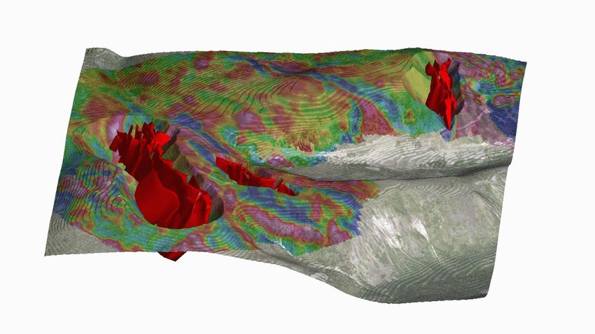
Location

    Road access with year-round exploration potential

    11km from existing & permitted Baker Mill

    45km NW of Kemess Gold Copper Mine & Power

    Proven & profitable mining jurisdiction

    First Nations agreement signed

    5 year exploration permit granted

    Sturdee Airstrip 13 km southeast of Lawyers

    Upgrading access with three 30 tonne bridges

7   TSX/V : BNCH | OTCQB : CYRTF | WKN : A2JM2X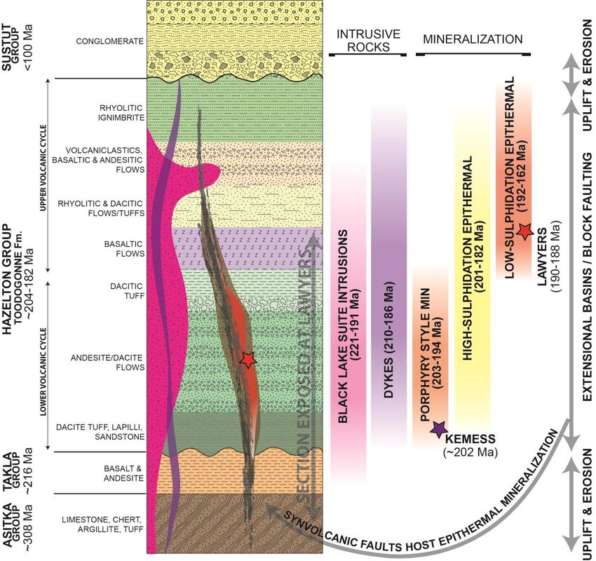
Property Overview
STRATIGRAPHY                                      STRUCTURAL DOMAINS              RADIOMETRICS K/Th
HAZELTON GROUP                                    FAULTS CONTROL MINERALIZATION   CORRELATION WITH MINERALIZATION

          2020 Mapping Focus

0     2         4 km

8   TSX/V : BNCH | OTCQB : CYRTF | WKN : A2JM2X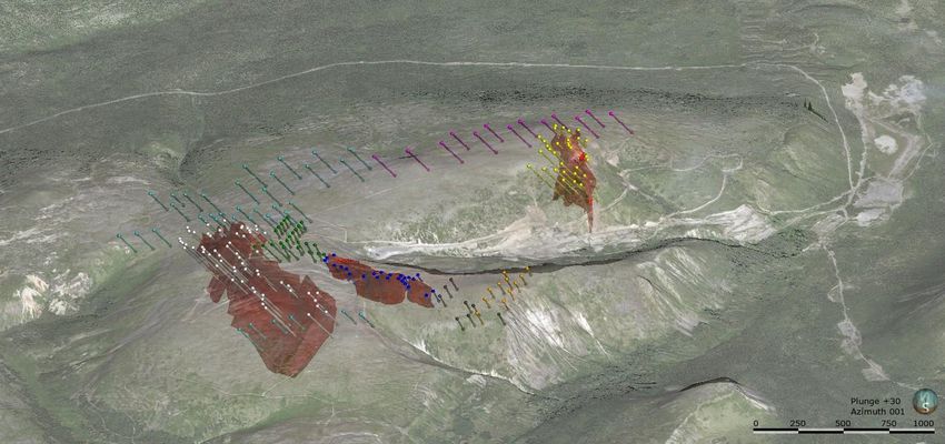
The Toodoggone Mineral District and Lawyers Stratigraphy

                       Round
                      Mountain

                             2020 Mapping Focus
                                                 AGB
                               Silver
                 Artic         Pond Cliff Creek
                                              Dukes Ridge
                                        Phoenix

                E-Grid                                   Marmot East
                                           Marmot

                                       Black Lake
                                                            Silicon
          Fault – Assumed
          Fault – Inferred                                  Valley
          Fault – Observed

          Conglomerate
          Black Lake Intrusive
          Basalt
          Hornblende Phyric Andesite
          Crowded Porphyry Andesite
          Andesite
          Lapilli Tuff
          Quartz Eye Tuff
          Limestone                         0        2           4 km

9   TSX/V : BNCH | OTCQB : CYRTF | WKN : A2JM2X
Structure
STRUCTURAL DOMAINS
Isolate structurally bound blocks with similar geologic   NW to NNW TRENDING FAULTS (Syn / Post-Min)
characteristics - compare apples to apples
                                                          •   Dominant structural features on property

                                                          •   NW to NNW (310 + 340°) striking with subvertical or steep SW or
                                                              NE dips

                                                          •   Normal displacement; likely reactivated at some time (strike-slip)

                                                          •   Oldest structures on the property representing syn-volcanic growth
                                                              faults that formed during lower Jurassic extension and block
                                                              faulting

                                                          •   Act as conduits for later intermediate / mafic dykes

                                                          •   Similar orientation as the CC-DR-PX and AGB hydrothermal systems
                                                              (mineralized)

                                                          •   Manifest as m-scale, sub-vertical fracture zones that are variably
                                                              altered (silica +/- pyrite +/- sericite) and mineralized (low to high-
                                                              grade min)

 0        2      4 km

10     TSX/V : BNCH | OTCQB : CYRTF | WKN : A2JM2X
Structure – 2019 Ground Magnetics
• Excellent correlation with mapped surficial structures
• Faults acted as conduits for mineralizing fluids and therefore control the mineralization
• Mineralized zones occur in the hanging wall of the fault structures associated with magnetic
mediums
• Numerous new targets identified for follow-up work and testing in 2020
• Ground magnetic surveys are planned at several zones
Cliff Creek mineralization AGB mineralization associated in
associated in part with these part with these structures
structures
Dukes Ridge and Phoenix
mineralization associated in part
with these structures
0 2 4 km
11 TSX/V : BNCH | OTCQB : CYRTF | WKN : A2JM2XAlteration
With proximity to mineralized zones, a
range of different alteration assemblages
are recognized, from distal to proximal:
• Propylitic – epidote, chlorite
• Hematite – pervasive alteration and
replacement of mafic minerals
• Phyllic (QSP) – quartz-sericite-pyrite
alteration
• Silicic – microcrystalline quartz, silica
flooding
• Potassic – fine-grained potassium
feldspar as adularia ± sericite
12 TSX/V : BNCH | OTCQB : CYRTF | WKN : A2JM2XAlteration – K/Th Radiometrics
Round
Mountain
Historic In 2018 Benchmark completed a large airborne radiometric survey
Tailings
Silver
Pond
AGB Camp • There is a very good correlation of elevated K/Th ratios (here shown in red and
Artic Cliff Creek
Dukes Ridge pinks) to known areas of mineralization.
Phoenix
• The strong response is a result of the addition of potassium to the volcanic host
E-Grid Marmot East
Marmot
rocks as they were altered by the mineralizing fluids.
• 100% of known occurrences are associated with radiometric highs.
Black Lake
Silicon
Valley
Resource Expansion
Zones
• Therefore, radiometrics is a very powerful targeting tool.
Inaugural Drilling in Road Access
2020 to Kemess
Early Stage Exploration 45 km SE
Targets
13 TSX/V : BNCH | OTCQB : CYRTF | WKN : A2JM2XMineralization
Mineralization occurs in two discrete styles:
1. Phoenix-style mineralization is hosted within discrete
quartz veins measuring approximately 1-8 metres
wide. The veins contain semi-massive sulphides,
including acanthite, sulfosalts, chalcopyrite, pyrite
and native silver.
2. Broad zones of multiphase hydrothermal breccias
composed of multi-generational chalcedony and quartz-
hematite veining. The mineralized veins contain
abundant fine to medium grained sulphides (acanthite,
sulfosalts, chalcopyrite, and pyrite) and native gold, silver,
and electrum.
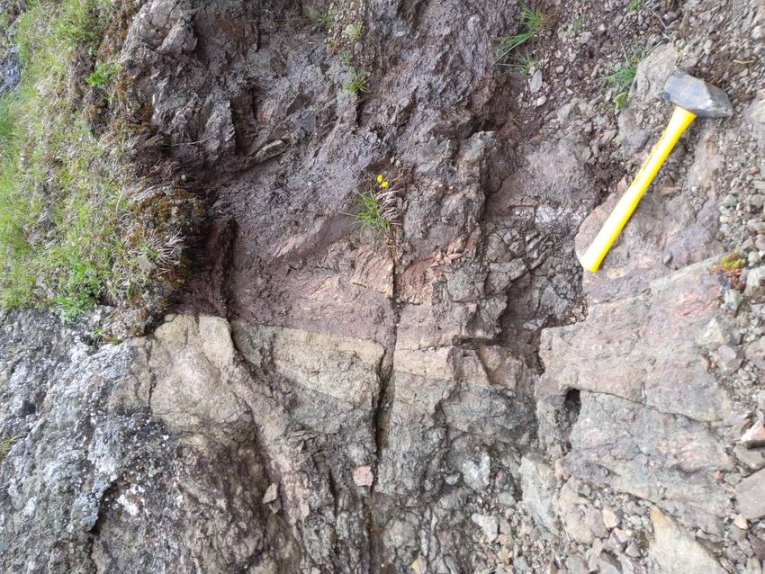
14 TSX/V : BNCH | OTCQB : CYRTF | WKN : A2JM2XCliff Creek Mineralization 1ST
1ST = Sooty thin sulphide veins
• mm scale
• mineralized, gold/silver sulfosalts
SEQUENCE OF VEINING / MINERALIZATION
2nd
2ND = Translucent grey quartz veins and stockwork silica flooding
• mm to cm scale
• mineralized, gold/silver sulfosalts (less so than 1)
• hydrothermal breccia
3rd
3RD = Milky quartz open space filing veins
• terminating crystals often amethyst
• often crack and fill of type 1/2 veins, using the same plane of weakness
4TH = Breccia Veining - Hematite breccia
• often associated with the zones of mineralization
• not mineralized but contains clasts of mineralized 1/2 veins
4th
5TH = Calcite veins, crack and fill, re-brecciation
• reactivate mineralized veins/zones
• often creating brecciated zones within the zones of mineralization
• this could be space filling fluids in rubble zones from brecciated associated with earlier events?
• discrete calcite veins outside of mineralized zones suggest this event doesn’t have the pressure to cause
brecciation 5th
15 TSX/V : BNCH | OTCQB : CYRTF | WKN : A2JM2XThe Geological Model – Low Sulphidation Epithermal System
T°C
SULPHIDATION
. STATE
Log f (S2)
2020 Mapping Focus
B’
A A’
B
Fault – Assumed
Fault – Inferred
Fault – Observed
Conglomerate
Black Lake Intrusive
Basalt
Hornblende Phyric Andesite
Crowded Porphyry Andesite
Andesite
Lapilli Tuff
Quartz Eye Tuff
Limestone 0 2 4 km
16 TSX/V : BNCH | OTCQB : CYRTF | WKN : A2JM2XThe Geological Model – Low Sulphidation + Porphyry Potential?
Generalized cross section of the Toodoggone district
The Mineral Deposits Research Group (MDRU) at the University of British
Columbia is shedding light on the relationships between the porphyry and
epithermal mineralization of the Toodoggone (link to report).
• They suggest historically mined and explored epithermal deposits are AGB
part of larger porphyry systems.
• This is based on a new exploration framework and geochemical index
(MPIx) for defining porphyry potential. CLIFF CREEK
• MDRU determined several low-sulphidation epithermal systems have SILVER POND?
numerous features that are indicative of the shallow parts of a porphyry
system including the Cliff Creek zone on the Lawyers property. ?
• Ongoing work by Benchmark has identified an extensive (1.3 by 1.4 km)
zone of clay alteration, known as the Silver Pond Zone.
• This may be the manifestation of a deeper high-sulphidation or
porphyry environment
Generalized cross section of the Toodoggone district (based on Diakow et al., 1993) showing location of the
mineral deposits and prospect relative to the typical porphyry alteration zoning (based on Sillitoe, 2010), modified
from MDRU/GBC 2019 Report.
17 TSX/V : BNCH | OTCQB : CYRTF | WKN : A2JM2XLarge Resource Expansion Areas with New Discovery Potential
Gold-Silver Zones Over
Radiometric Geophysics
5 Million oz Gold-Silver Exploration Target
Round
Mountain
90% of the 140 km2 property is underexplored
• Five resource expansion zones
Historic
Tailings
• Two new discovery zones for 2020 drill testing
Silver
Pond
AGB Camp • Six early stage exploration targets for new discoveries
Artic Cliff Creek
Dukes Ridge
Phoenix
Previous mining overlooked the bulk-tonnage and porphyry potential
• High-grade drill intercepts within wider mineralized envelopes
E-Grid
• Open at depth - average drill hole under 100m
Marmot East
Porphyry • Copper porphyry targets associated with large zones of clay alteration, soil and
Targets
Marmot radiometric anomalies, and key stratigraphic horizons
Black Lake High Grade Drill Results* Bulk-Tonnage Drill Results*
Silicon 3.00m at 259 g/t gold & 3,320 g/t silver – AGB 25.00m at 2.79 g/t gold & 177 g/t silver – AGB
Valley
Resource Expansion 3.05m at 52 g/t gold & 846 g/t silver – Dukes 33.53m at 5.76 g/t gold & 128.65 g/t silver – Dukes
Zones
2.40m at 87 g/t gold & 2,407 g/t silver – Cliffs 36.50m at 2.68 g/t gold & 82.57 g/t silver – Cliffs
Inaugural Drilling in Road Access
2020 to Kemess 0.90m at 132.5 g/t gold & 8,560 g/t silver - Phoenix 26.00m at 2.42 g/t gold & 100.26 g/t silver - Phoenix
Early Stage Exploration 45 km SE
Targets
18 TSX/V : BNCH | OTCQB : CYRTF | WKN : A2JM2XCliff Creek Zone - Discovery & Growth
NEW PARALLEL ZONE DISCOVERED
19CCDD025: 36.3 m @ 3.19 g/t AuEq
**
WSW Incl. 3.23 m @ 18.24 g/t AuEq ENE
The Cliff Creek Zone extends for over 1.2 km along
strike and 250 metres vertical depth and remains
open
Broad parallel zones of bulk-tonnage mineralization
and high-grade mineralization hosted in the hanging-
wall of steeply northwest dipping faults
New zones are being discovered within 50 metres 50M FROM
of historical underground workings and drilling MAIN ZONE & ONLY
Historical drilling not fully JUST DISCOVERED
sampled.
Drilling highlights: Multiple parallel zones
• 2.68 g/t Au, 82.57 g/t Ag or 3.71 g/t AuEq across 36.50 projected along strike. POTENTIAL FOR
metres core length
NEW DISCOVERIES
• 87.00 g/t Au, 2407.0 g/t Ag or 117.01 g/t AuEq across 2.4
metres core length
*Drill core-lengths
OPEN AT DEPTH
19 TSX/V : BNCH | OTCQB : CYRTF | WKN : A2JM2XCliff Creek Zone Exploration Target
1.92 Moz AuEq EXPLORATION TARGET Cliff Creek bulk tonnage Exploration Target ranges from 30.6
(CLIFF CREEK ZONE LONG SECTION) – 1.2 Km
million tonnes to 34.7 million tonnes with a range in grades
of 1.71 g/t AuEq to 1.73 g/t AuEq at a lower cutoff of 0.5 g/t
Au, yielding an estimated range of 1,682,000 AuEq
BLOCK MODEL ounces to 1,924,000 AuEq ounces.*
86% of the AuEq ounces are within 300m of surface.
Pit shell model
Cliff Creek remains remains open in all directions.
Exploration Target*** – Range of Tonnes and Grades
AuCutoff Tonnes Avg au g/t au oz Avg ag g/t ag oz Avg EQ Au ppm EQ Au oz
AGB, Duke’s Ridge, Phoenix, and Phoenix East zones have
0.2 61,969,042 0.866 1,725,597 25.66 51,124,711 1.154 2,299,767
similar resource potential.
0.5 34,687,453 1.278 1,425,494 39.791 44,375,916 1.725 1,923,869
2 4,349,789 3.678 514,302 128.402 17,956,826 5.12 715,971
0.2 55,046,348 0.859 1,520,935 25.486 45,104,233 1.146 2,027,490
0.5 30,622,770 1.266 1,246,245 39.451 38,841,095 1.709 1,682,460 *A silver to gold ratio of 80:1 has been used in the calculation of AuEq
**Total ounces may not add due to rounding.
***The tonnes, grade and ounces presented are an Exploration Target, and are conceptual in nature,
2 3,655,852 3.794 445,972 130.289 15,313,962 5.258 617,960 there has been insufficient exploration to define a mineral resource and it is uncertain if further
exploration will result in the target being delineated as a mineral resource. The Target has not been
A full table of results, modeling details, and parameters can be found on the Benchmark Metals website and in the
evaluated for reasonable prospects for future economic extraction as metallurgical work and drilling are
February 28th press release. planned and ongoing.
20 TSX/V : BNCH | OTCQB : CYRTF | WKN : A2JM2XMultiple Resource Zones for Expansion & Definition
MINERALIZED DOMAINS USED FOR EXPLORATION TARGET, MINERAL
INVENTORY AND MODELLED PIT SHELLS ON GROUND MAGNETICS
Following the 2019 drilling program Benchmark
has defined five discrete mineralized zones that
will be the focus of resource definition and AGB
expansion drilling in 2020.
Up to 50,000 m of expansion and definition Mine Portal
drilling will target all of these zones in 2020. DUKE’S
RIDGE
A global resource estimate will comprise one
or more of Cliff Creek, Duke’s Ridge, Phoenix PHOENIX
and AGB.
PHOENIX EAST
Six additional exploration targets across the
140 km2 property could provide additional
ounces.
21 TSX/V : BNCH | OTCQB : CYRTF | WKN : A2JM2XProposed 2020 Exploration Program Outline
• Up to 50,000 metres of drilling (2 RC drill rigs and 2-3 diamond
drill rigs);
• Induced Polarization (IP) and Magnetotellurics (MT) geophysical
survey;
• Ground magnetics/VLF at multiple zones;
• Detailed bedrock, alteration, and structural mapping;
• Extensive soil and rock sampling across new exploration targets;
• Advancing 6+ tertiary targets for new discovery potential;
• Advancing Cu-Au porphyry target areas;
• Metallurgical work is ongoing;
• Commencing geotechnical data collection
• Baseline environmental data collection
22 TSX/V : BNCH | OTCQB : CYRTF | WKN : A2JM2XSoil & Rock Sampling
• 3788 planned soil samples covering Kodah
Gold & Silver Kodah
underexplored regions of the 140 Mineralized Corridor Round Mountain
km2 property Round >15 km
Mountain
• 100x200 m soil grid covering
prospective Jurassic volcanics and Arctic Arctic
AGB AGB
geophysical anomalies Silver Pond
Silver Pond
Dukes Ridge Dukes Ridge
• 100x50 m and 50x50 m grids at Phoenix
Cliff Creek
Phoenix
Cliff Creek
AGB to test geophysical anomalies
E-Grid
• >1000 planned rock samples across E-Grid Marmot Marmot East Marmot
Marmot East
the property
• Red squares signify regions where Black Lake Black Lake
ground geophysical surveys will be Alt Corridor Silicon Valley Alt Corridor Silicon Valley
completed
AuEq80
2019 Soil Sample
2020 Proposed Soils
0 2 4 km 2020 Ground Geophysics
23 TSX/V : BNCH | OTCQB : CYRTF | WKN : A2JM2XAdvanced Exploration Targets - Marmot
• Marmot & Marmot East are located in the east-central portion
of the Lawyers Property and directly along strike from the main
Lawyers trend mineralization approximately 3 km to the north.
• The zone spans 500 by 250 metres and is defined by bedrock
mapping, soils, rock samples (Table 1), and is situated within a
larger 2400 by 650 metre K-radiometric anomaly.
• The structure, mineralization, and alteration relationships at
the Marmot zones are consistent with other zones on the
Lawyers Trend, where hydrothermal low-sulphidation systems
developed within pre-existing fault systems that acted as
conduits for fluids to migrate and precipitate.
• The relative geometry of these fault systems possibly controls
the distribution of high-grade mineralization where faults of
different orientations intersect, as observed at both Marmot
and Marmot East.
• Ground geophysics, mapping, soil & rock sampling, and drilling
are planned for the Marmot zones in 2020.
2019 rock sample results
Gold
Sample Silver g/t *AuEq g/t
g/t
Y948686 24.2 128 25.80
Y948680 16.1 1425 33.91
Y948673 6.0 318 9.98
Y749851 4.51 556 11.46
Y948679 3.63 656 11.83
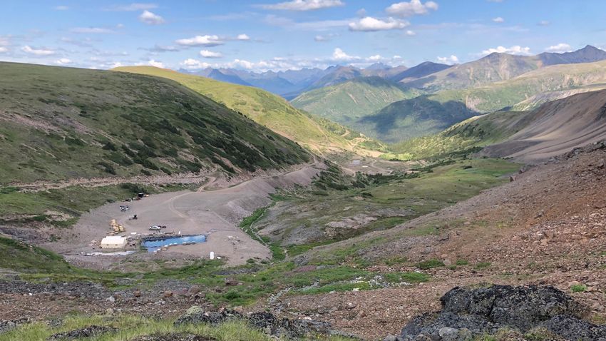
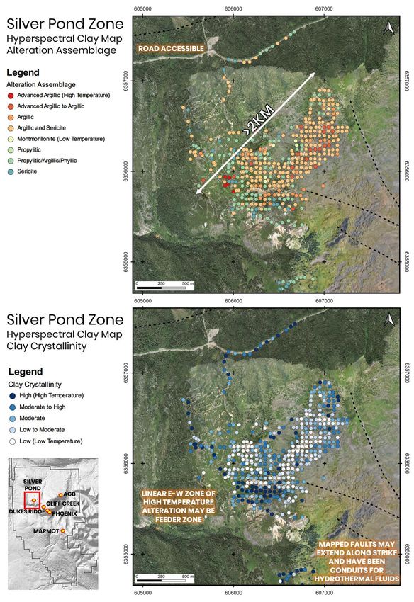
24 TSX/V : BNCH | OTCQB : CYRTF | WKN : A2JM2XAdvanced Exploration Targets – Silver Pond
• A hyperspectral or SWIR (short-wave
infrared) analysis of clay samples and
detailed clay mapping was completed over a
large (>4km2) advanced argillic alteration.
• Alteration assemblages and large-scale
zonation patterns are helping vector towards
potential porphyry or high-sulphidation
mineralization.
• This large zone of alteration has never been
drilled, mapped, or effectively explored and
is only 850 m northwest of the low-
sulphidation mineralization at Cliff Creek.
• This type of alteration is related to
moderate-high temperature and high acidity
fluids that are typically associated with the
surface expression of the fluids from
porphyry and high-sulphidation systems.
• Analysis of soil and rock geochemistry
indicate that there is an association between
Au-Ag mineralisation and elevated Cu, Mo,
Zn, As, Sb and Te at Silver Pond, whereas at
AGB, Cliff Creek and Dukes Ridge this metal
association is not evident.
Schematic illustration of alteration zoning and overprinting relationships in a porphyry system (modified after
Holliday and Cooke 2007; Cooke et al. 2014; Cook et al., 2017).
25 TSX/V : BNCH | OTCQB : CYRTF | WKN : A2JM2XResource & Exploration Planned Drilling Overview 2020 26 TSX/V : BNCH | OTCQB : CYRTF | WKN : A2JM2X
2020 Proposed Drill Program
                                                             Prospect      Metres   Drill holes
                                                             Cliff Creek   12755    63
                                                             AGB           6240     33
                                                             Dukes         3510     21
Drill                     Metres             % of Total      Ridge
Category                                      Drilling
                                                             Phoenix       460      3
Pit-infill &              31200                   62
Resource                                                     Prospect      Metres    Drill holes
Expansion                                                    Cliff Creek   5730      36
Exploration               11600                   23         AGB           3270      13
Fences
                                                             Dukes         1380      11
CC-DR                      3740                    8         Ridge
Connector                                                    Phoenix       1220      8
Zone
                                                             Prospect      Metres    Drill holes
Exploration                3500                    7
“Greenfield”                                                 CC-DR         3740      23
                                                             Connnector
TOTAL                     50040                  100
                                                             Prospect      Metres    Drill holes
                                                             Marmot        1500      3
                                                             Lake
                                                             Silver Pond   2000      4
                                                             Clay

     27        TSX/V : BNCH | OTCQB : CYRTF | WKN : A2JM2X
Planned AGB Drilling 28 TSX/V : BNCH | OTCQB : CYRTF | WKN : A2JM2X
CC North Resource Drilling

29   TSX/V : BNCH | OTCQB : CYRTF | WKN : A2JM2X
CC South Resource Drilling

30   TSX/V : BNCH | OTCQB : CYRTF | WKN : A2JM2X
Dukes Ridge + Phoenix Resource Drilling

31   TSX/V : BNCH | OTCQB : CYRTF | WKN : A2JM2X
2020 CORPORATE OBJECTIVES
                                  2020                                                              2021
             Q2 2020                                   Q3 2020                     Q4 2020                        Q1 2021                     Q2 2021

       50,000m drill program,                   Commence drill and field      Geological interpretation.    Interpretation and 43-101        Commence PEA.
      metallurgy, infrastructure                 exploration programs.         Advanced metallurgical,         resource estimation.      Geology and Engineering
           improvements.                       Geotechnical & Engineering   permitting, and environmental                               programs to support future
                                                        studies.                       studies.                                              feasibility study.

*Quarters are calendar year

32       TSX/V : BNCH | OTCQB : CYRTF | WKN : A2JM2X
Value Proposition
OPPORTUNITY NEAR-TERM OBJECTIVES
• 100% ownership of Lawyer’s gold and silver project • Up to 50,000m drill program focused on expansion and definition
• Located in an area of proven prolific mineralization drilling resource
• 140 km2 land package is 90% underexplored • Drill testing geophysical and geochemical targets for new discoveries
• Access to existing mining infrastructure • Expanded metallurgical test program investigating the
• Mining-friendly, low-risk jurisdiction mineralization for potential bulk-tonnage mining.
• Fully funded, +$10M in working capital • Geotechnical program to potentially minimize open pit strip ratios
• Near term resource estimate • Develop additional Au-Ag and Cu-Au exploration targets
• New Resource Estimate following drill results
TRACK RECORD AND TEAM
• Experienced team with decades of mining experience
• One of the Metals Group of Companies
LONGER-TERM OBJECTIVES
• PEA (Preliminary Economic Assessment)
• FS (Feasibility Study)
• Re-establish future mining
33 TSX/V : BNCH | OTCQB : CYRTF | WKN : A2JM2XJeremy Yaseniuk
Corporate Development
jeremyy@bnchmetals.com
Contact 1.604.773.1467
Head Office
10545 45 Avenue NW Jim Greig
250 Southridge, Suite 300 President
Edmonton, Alberta Canada jimg@bnchmetals.com
www.benchmarkmetals.com 1.604.260.6977
John Williamson
Chairman & CEO
johnw@bnchmetals.com
TSX/V : BNCH | OTCQB : CYRTF | WKN : A2JM2X 34Part of the Metals Group of Companies 35 TSX/V : BNCH | OTCQB : CYRTF | WKN : A2JM2X
You can also read