Geology of the Permian Basin - Tobosa Basin Stratigraphy (Mid. Ord - Miss.) Lowell Waite UT Dallas Geoscience Permian Basin Research Lab ...
←
→
Page content transcription
If your browser does not render page correctly, please read the page content below

Geology of the Permian Basin
Tobosa Basin
Stratigraphy
(Mid. Ord. – Miss.)

Lowell Waite
UT Dallas Geoscience
Permian Basin Research Lab
10/25/2021

Geology of the Permian Basin: ELS (Endeavor Lecture Series)

      Horseshoe Atoll

      Tectonic history – Part 1 (Big Picture)

      Tectonic history – Part 2 (Regional elements: ARM, CBU, MFB)

      Basement

      Cambrian – Lower Ord (Wilberns/Bliss Ss., Ellenburger Gp)

      Tobosa Basin stratigraphy (Mid Ord. – Mississippian)

      Pennsylvanian (Morrow-Atoka-Strawn-Canyon-Cisco)

      Lower Permian (Wolfcamp – Spraberry)

      Middle and Upper Permian / Permian Basin petroleum system
Tobosa Basin stratigraphy: overview
                            • Post-Ellenburger: Tobosa Basin is first
                              isolated as a moderately-subsiding
                              depositional basin

                            • West Texas region is part of a long-lived
                              passive continental margin (Middle
                              Ordovician to Late Mississippian); approx.
                              150 million years in duration

                            • During much of this time, Tobosa Basin
                              was located in low tropical latitudes, far
                              from major sources of terrigenous
                              clastics – perfect setup for massive
                              carbonate production
                            • Two megacycles of eustatic sea-level
                                • Middle Ord. – Early Dev. epeiric sea
                                • Late Dev. – Mississippian epeiric sea

                            • Three major reservoir units (Fusselman,
                              Wristen Gp., and Thirtyone)

                            • Three major source rocks (Lower
Source Rock   Reservoir       Simpson, Woodford, and Barnett)
Tobosa Basin: Megacycle 2 (Mid. Ord. – Early Dev.)
Sea-level analysis
• Begins with cratonic submergence and
transgression of epeiric sea during Middle
Ordovician time (following late Early
Ordovician lowering/exposure/karsting)
• Long-term transgression throughout
Middle and Late Ordovician time with
pronounced lowstand near the Ord – Sil
boundary (Subcycle 2a); deposition of
1 2 3 Simpson and Montoya Groups
• Renewed transgression thoughout
1a 1b 2a 2b 3a 3b
4
Silurian, with sea-level reaching all-time
4a high 4b during 4c Late Silurian, followed by
rapid, significant
Ochoan
sea-level fall with
Trans. Ss.
Fusselman- eroded/ U. Miss./Barnett – WFMP C2 – SPBY/B.Spr.-
Permian
eroded/
not deposited
Ellen- Simpson-
Wristen- not Lower Miss. Lime –
WFMP D – WFMPwidespread
Dean - Tans.-Yates exposure/uplift event during
A- Quen.-SNRV
burger Montoya L. Strawn – WFMP B -
Basin (Basement) Thirtyone deposited Woodford EarlyC1Devonian
Morr. - Atoka WFMP
GBRG
San Andres (Subcycle 2b); deposition
stratigraphic
units
of Fusselman Formation, Wristen Group,
and Thirtyone Formation
Early Mid. Late Early Mid. Late Lland. Wn. Lu.-
Pri. Early Mid. Late Early Middle Late E. M L. Cisuralian Gua. Lop. E. Middle Late
Silurian Devonian Mississippian Triassic
Cambrian Ordovician Penn. • Permian
Greenhouse climate
icehouse (brief
540 520 500 480 460 440 420 400 380 360 340 320 300 280 260 240
200 220
Icehouse Greenhouse I Greenhouse Icehouse phase spanning Ord-Sil boundary)
Greenhouse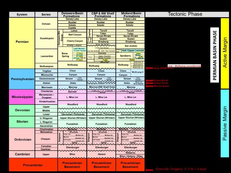
Cycle 2a: Simpson and Montoya Groups
                                        Montoya Group (Upper Ordovician)
                                         • A thick (up to 600 ft) series of carbonate ramp
                                           deposits; four formations, from oldest to youngest:
                                            • Cable Canyon: gravel conglomerates and dolomite-
                                              cemented quartz sandstones

                                            • Upham: massive coarse-grained skeletal wacke- pack-,
                                              and grainstones (open marine fauna)
                                            • Aleman: chert-rich limestones (incl. coral bafflestones)

                                            • Cutter: fine-grained argillaceous dolomudstones and
                                              lime mudstones (low energy)

                                        Simpson Group (Middle Ordovician)
                                        • A mixed sandstone/shale/carbonate succession
                                          consisting of five formations, from oldest to youngest:
                                              • Joins Fm: argillaceous limestones and dolomites

                                   ~
                                              • Oil Creek, McLish, and Tulip Fms: basal sandstones
                             Ft. Pena
                              Alsate            overlain by shales and shaley limestone
                            Marathon
                            Limestone         • Bromide Fm: interbedded sandstones, shales, and
                                                thick fossiliferous limestones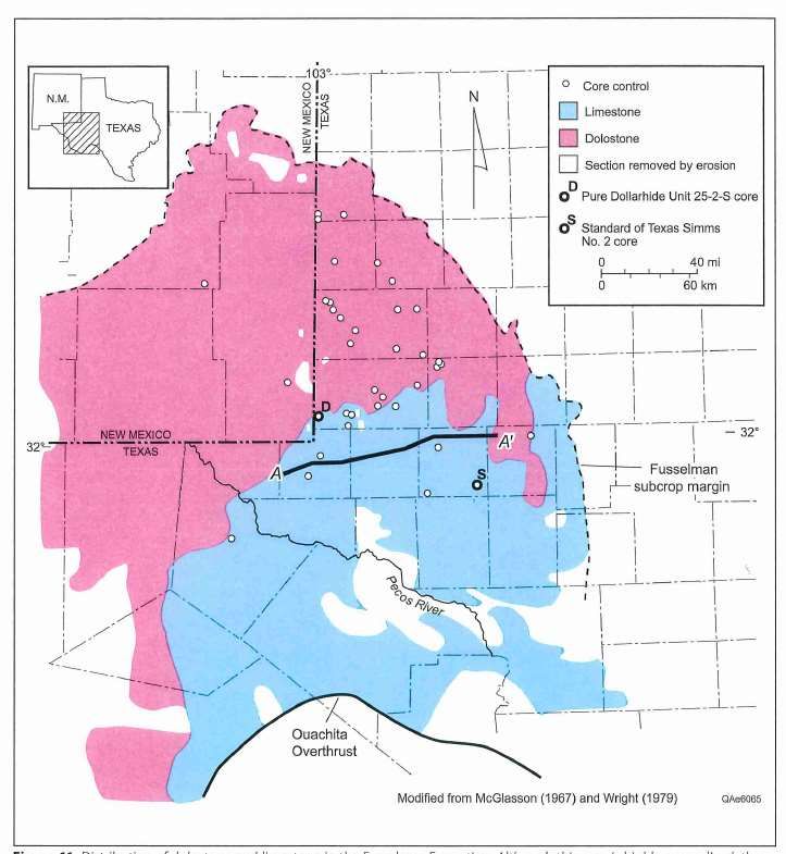
Well log response
 Simpson paleogeography                                     of the
                                                            Simpson Group
                                                            showing
                                                            alternation of
                                                            shales, sands,
                                                            and limestones

                                                            Oil Creek shales:   • Cumulative oil production
                                                            organic-rich          of ~ 100 million barrels;
                                                            (source rock for      individual fields are small
                                                            underlying
                                                                                • Main producing units are
                  (Harrington, 2019)                        Ellenburger
                                                                                   thin sandstones
                                                            reservoir)
                                                                                   Simpson production
                                                                                   mainly limited to CBU

Simpson isopach

                                       (Harrington, 2019)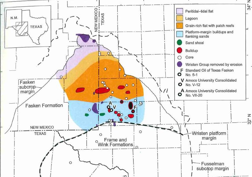
Upper Ordovician
Montoya Group

Middle – Late Ordovician: Biologic, Climatic, & Tectonic Trends / Events
GOBE = Great Ord. Biologic Event
Tectonic evts.
NA Ash Beds7
Global Inorganic
Microphyto-
Chert/Phosp.6
Inverterate
Permian
Diversity4
Diversity4
Depoits5
Stages
plankton
Global
Series1
Eustacy Carbon
Glacial
British
Marine
Period
Global
Age
Series North American Basin (Haq & Schutter, Isotopes
(Ma) Series 2,3 Stratigraphy (Bergstrom Montoya time marked by:
2009)
et al, 2008)
444 • High marine invert.
Hirnan.
444.5 Gamachian diversity
Icehouse (cool mode)
Ash-
Cincin-
Hirnan-
Taconic Orogeny
natian
Tippecanoe I supersequence set
gill tian
Kat- Richmondian Montoya Event • Onset of brief ice age
Upper
ian Group
Maysvill.-Eden. • High occurrence of
Cara- Gutten-
ORDOVICIAN
446 berg sedimentary chert
Sand- doc Mohawkian Event (oceanic upwelling)
bian
461
Llande. Simpson Mid
Darri- • High occurrence of
(warm mode)
Darri-
Middle
wilian Llanvirn White- Group wilian
Event
volcanic ash beds
468 rockian
Dapin- • Taconic orogeny
ginian GOBE (eastern U.S.)
472 Arenig
Greenhouse
Floian
478.5 Ellenburger
Lower
Sauk III
rise
Ibexian
# species
Trema- Trema- Group
(x100)
# genera
docian docian
(x100)
488.5
1 3 5
1Harland 4Servais
-4 0 +4 5 15
et al., 1989 et al., 2009 7Huff et al., 1992 13Ccarb
2Finney & Berry, 2010 5Frakes et al., 1992 del
3Haq and Schutter, 2008 6Pope & Steffen, 2003 (Waite,2017, unpublished)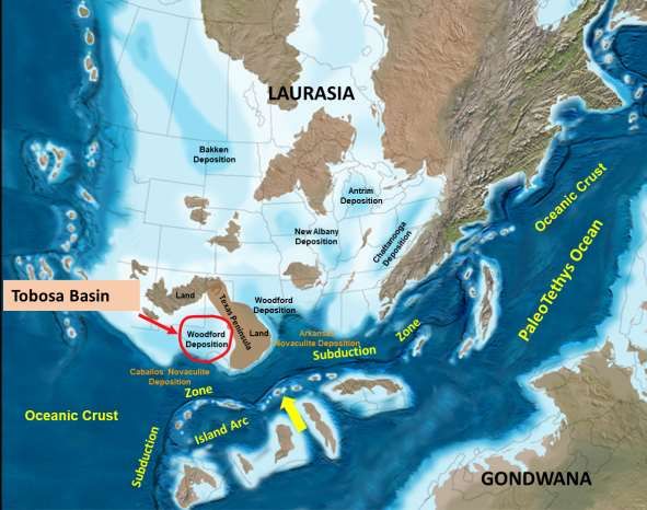
• Montoya rocks in the Permian Basin are
Late Ordovician ocean circulation                     marine carbonates (dolomites,
                                                      limestones) that contain a great amount
                                                      of chert (silica) and phosphate
                                                     (likely due to upwelling)

                                                     (Harrington and Ruppel, 2019)

                                    (Pope, 2004)

                                                     (Pope, 2004)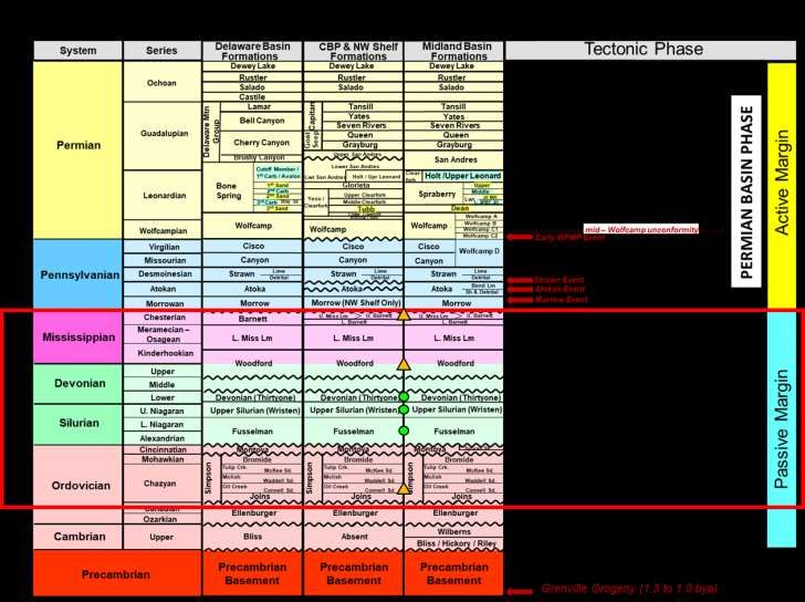
Montoya lithologies

                                            (cherty)   • Dolomite facies are prevalent to the north and
                                                         west in New Mexico

                                                       • Shallow water cherty limestone facies occur to
                                                         the south and east throughout west TX,
                                                         changing southward to chert and deep-water
                                                         limestones in the Marathon foredeep

                                                       • Note the limited distribution of the Sylvan Shale
                                                         along the eastern side of the Tobosa Basin
                                                         (Midland Basin – Howard-Glasscock-Reagan Cos.)
                                                       • Little to no oil or gas production from Montoya
                                                         rocks in the Permian Basin

                      (Harrington and Ruppel, 2019)
SUBCYCLE 2b: SILURO-DEVONIAN FUSSELMAN FORMATION WRISTEN GROUP THIRTYONE FORMATION
West – East cross-section across Tobosa Basin showing thickness and facies of Siluro-Lower Devonian units

                                                                                      (Ruppel, 2019)
Lower Silurian Fusselman Fm. facies
• Shallow-water carbonates, fining-upward icehouse cycles w/ high-energy
ooids at base of cycles
• Dolomite to NW, limestone in SE
2 cm
Fusselman isopach
Caballos
Chert
(Ruppel, 2019)FUSSELMAN OIL FIELDS OF THE PERMIAN BASIN
• Two producing trends:
• Structures on CBP
• Strat traps on erosional subcrop
• Cumulative oil production > 355 million barrels
Woodford shale (seal)
oil accumulation
trapped at pinch-out
(associated with
uplift/truncation
during Early
Devonian);
reservoir porosity
created/enhanced
immediately below
(Dutton et al., 2005) unconformityMid – Upper Silurian Wristen Group • Fasken Fm: Reef-bearing shallow-water
carbonates in north; platform margin
Late Silurian to Earliest Devonian (Wenlockian to Lochkovian)
• Frame and Wink Fms: Deeper-water
Water Depth carbonate facies (slope to basinal) in south
~1200 to 1300 ft
Fasken Isopach Frame Isopach Wink Isopach
Slope to Basinal Slope to Basinal
Shelfal /
Facies Facies
Platform
Facies
(From Ruppel, Undated BEG Wristen Draft Report)Wristen Group Facies • Wristen (Fasken) buildups and shelf carbonates
have produced more than 880 million bbls
Structures on northern
portion of CBU
Stromatoporoid Coral
packstone boundstone
(Ruppel et al., 2020) (Dutton et al., 2004)Lower Devonian Thirtyone Formation
• Oversteps underlying Wristen Group, filling-in basin during
Early Devonian lowering of sea-level
(Ruppel et al., 2020)• Like the Montoya, carbonates of the Thirtyone are rich in siliceous chert;
these cherty limestones contain porosity on many uplifted blocks of the
Central Basin Uplift
• Much of chert derived from sponges (not oceanic upwelling);
deep-water flows ?
(Ruppel et al., 2020)
(Saller et al., 1991)Lower Devonian Thirtyone Formation
Oil Reservoir (Ruppel and Barnaby, 2001)
• > 750 million barrels of oil produced
• Potential remaining reserves of 650 MMBO
Thin-section photomicrograph showing spiculitic cherty
limestone (sponge-rich) with abundant moldic porosityTobosa Basin: Megacycle 3 (Mid Dev. – end Miss.) Sea-level analysis
• Follows a sea-level fall of >200 m, resulting
in non-deposition/erosion event lasting
approx. 30 million years (missing section)
• Rapid, short-term transgression during
late Devonian time results in deposition of
Woodford Shale, followed by brief SL fall
• Renewed transgression during latest
Devonian followed by long-term highstand
1 2 3 throughout Mississippian results in
deposition of Lower Miss. Lime and Upper
1a 1b 2a 2b 3a 3b
4
Miss Lime / Barnett Shale
4a • Rapid, 4c
4b significant sea level fall (~200m)
terminates
Ochoan Megacycle 3, once again
Trans. Ss.
eroded/ Fusselman- eroded/ U. Miss./Barnett – WFMP C2 – SPBY/B.Spr.-
Ellen- Simpson- Dean - Tans.-Yates
Permian WFMP D – WFMP
not deposited
burger Montoya
Wristen- not
deposited
Lower Miss. Lime – exposingGBRG
A-
L. Strawn – WFMP B - large portions of N.Amer
Quen.-SNRV
Basin (Basement) Thirtyone Woodford Morr. - Atoka WFMP C1
stratigraphic including west Texas; coincides with onset
San Andres
units of active tectonic margin
Early Mid. Late Early Mid. Late Lland. Wn. Lu.- Early Mid. Late Early Middle Late E. M L. Cisuralian Gua. Lop. E. Middle Late
Cambrian Ordovician Silurian
Pri.
Devonian Mississippian Penn. • Greenhouse
Permian climate throughout; onset
Triassic
540 520 500 480 460 440 420 400 380 360 340 320 300 of280
major260
ice age240at end220of cycle
200
Icehouse Greenhouse I Greenhouse Icehouse GreenhouseW-E
West
Cross Section Showing Erosional Truncation At Base Woodford Unconformity
East
B
(Section flattened on top Woodford) B’
West East
Datum: Top Woodford
Woodford Woodford
Wristen
Sylvan
Fusselman
Ellenburger
Thirtyone
Wristen
Montoya Ellenburger
Fusselman Simpson
Ellenburger
Wristen
Montoya
Fusselman
500 ft.
Thirtyone B’
Simpson
B Thirtyone
Base Woodford Subcrop Displayed
• Sea-level fall during Mid Devonian time led to exposure of the Tobosa
Basin; exposed Wristen Thirtyone carbs are karsted
• Associated regional uplift (of uncertain cause) causes tilting along east side of Tobosa Basin and truncation of Siluro-
Devonian units: Fusselman, Wristen, Thirtyone (Simpson and Montoya were depositional pinchouts)
• Pinchouts form small stratigraphic traps directly underlying the organic-rich Woodford shale (prolific petroleum source rock)top Mid Devonian unconformity in the middle of the Midland Basin The unconformity as seen here is exposed in a conventional rock core from a measured depth of 11,295 ft. A “razor-thin” surface with micro- karst separates cherty limestones of the Early Devonian Thirtyone Fm (below) from organic-rich, pyritic black shales of the Late Devonian- base Early Mississippian Woodford Fm. (above)
Stratigraphy of the Tobosa Basin

 Middle – Upper      Upper Miss. Lime                  Barnett
  Mississippian
                     Lower Miss. Lime                  Shale          Megacycle
                                                                 3B
U. Dev. – L. Miss.             Woodford Shale                            3
Mid. – U. Devonian         missing (non-deposition/erosion)      3A
 Lower Devonian            Thirtyone Formation
 Middle – Upper
    Silurian                  Wristen Group                      2B
                                                                      Megacycle
 Lower Silurian              Fusselman Formation
                                                                         2
                              Montoya Group
 Middle – Upper
                                                                 2A
   Ordovician                    Simpson Group

Lower Ordovician            Ellenburger Group                         Megacycle
                                                                         1
Upper Cambrian          basal transgressive sand (Bliss)

                           Precambrian basement
Dawson Co. Martin Co. Upton Co.
Woodford – Mississippian Limestone - Barnett A A’
North South
• Tobosa Basin / passive margin tectonic phase ends; coincides
with a significant eustatic sea-level rise (birth and
development of Mississippian seaway) Wolfcamp
(Penn Sh;
Cisco –
D
Canyon)
• Two source intervals “sandwiched” between a shallow marine
Lwr Strawn
limestone Lm
Strawn Det
Atoka
Bend Lm
Atoka Shale & Detritals
Upper
Miss
Lm Morrowan Sh
Thirtyone
Lower
Miss
Lm
Wristen
Fusselman
WristenWoodford shale is part of an overall larger system of organic-rich black
Late Devonian Paleogeography shale deposition throughout eastern North America during Late
Devonian and Early Mississippian time
• Widespread flooding of North American craton
• Note low-lying Texas Arch to east of Tobosa Basin
(From R. Blakey)
(Ruppel et al., 2020)
25Midland Co. Canadian Co.
SW Pecos Co. Datum: top Woodford NE
(Midland (Anadarko
(Delaware
Basin) Basin)
Basin) Winkler Co.
VClay
(Central
Basin
GR Platform) Top Woodford
DLOG-R
Upper Woodford Avg TOC 5.0%
Avg TOC 7.0%
200 ft
Base Woodford
24
NE
200 ft.
Late Dev – Early Miss. Woodford Shale: A word-class source rock that
blanketed the Tobosa Basin
• One of the main petroleum source rocks in the Permian Basin region
• Dark black, silica- and pyrite-rich mudrocks
(Tim Reed, Pioneer)
SWWoodford black shale deposition:
• a mixture of pelagic “rain” and deep-water
mud-rich gravity flows
• Stratified water body
• Surface waters are fully oxygenated and support a
healthy population of planktonic organisms
• Bottom waters are anoxic (no bottom fauna to consume
deposited organic matter, ensuring burial / preservation
(Ruppel et al., 2020)Woodford Thermal Maturity Ro maturity values Woodford as a potential shale play:
< 0.6 non-generative • Delaware Basin: dry gas window
0.6-0.8 early oil window
0.9-1.1 peak oil window • CBP: early oil window
1.1-1.3 wet gas window • Midland Basin: wet gas to dry gas
> 1.3 dry gas window (MISSISSIPPIAN LIME
AND
BARNETT SHALEEarly to Late Mississippian facies of continental U.S.
• Following deposition of the
Woodford Shale, long-term sea-level
highstand conditions resulted in
development of an extensive
shallow-water carbonate platform
throughout North America
• Note position of Tobosa Basin on
southern margin of the platform
• Updip: shallow-water limestones
including crinoid-rich granistones
• Downdip: small sponge-rich reefs,
mud mounds, and deep-water shale
Mississippian: age of the crinoidsUpper Devonian –
rowian NA Stage
Mara- South- Permian
Age (Ma)
New Mexico Central Ft.
System
Basin Sequence Conodont
Series
Stage
thon ern Texas Worth
Mississippian outcrop Uplift Okla.
outcrop outcrop N
sub-
surface
Basin stratigraphy
(Dorabek and
zones
(Lane and
N S S W E W E Bachtel, 2001) Ormiston, 1982)
stratigraphy
PENN.
Strawn
Bash-
Absar.
La Tuna /
Low.
kirian
Pennsyl- Marble
Mor-
Atoka vanian Falls 15 primus
Gobbler Morrow(?)
323
Conodonts: an extinct group of jawless (not
Serpukhovian
14
vertebrates resembling eels, classified in studied)
U. Miss.
L. muricatus
Barnett
Chesterian
Upper
Tesnus
Lime
the class Conodonta. For many years, they 13
were known only from their tooth-like oral Barnett 12 unicornis
elements found in isolation and now Helms 11 naviculus
called conodont elements. They existed in the 331
Caney
10 G. bilineatus -
world’s oceans for over 300 million years, from C. altus-
MISSISSIPPIAN
Ran- M4 G. bilineatus -
the Cambrian to the beginning of the Jurassic. cheria 9
Merama-
C. charactus
Visean
Middle
Conodont elements are widely used as index A. scalenus -
cian
8 Cavusgnatus
fossils index fossil. L. Cruces White’s Barnett
Lower Crossing 7
Dona texanus
Kaskaskia II
Ana M3
Arecente Miss. 6
347
Osagean
Lake Valley
Lime- 5
Tierra anchoralis-
Blanco stone
4U latus
Tournasian Nunn M2 4L U. typicus
Lower
Alamagordo 3 L. typicus
Andrecito Chappel 2 Isosticha -
Weldon M1 U. crenulata
hookian
Kinder-
Caballero F
E L. crenulata
D sandbergi
1 C U. duplicata
(not B L. duplicata
358 studied) A sulcata
Caballos Wood- praesulcata
Famen-
Upper
DEV.
ford
ian
Percha Shale / Woodford Woodford expansa
Sly Gap
(from Ruppel et al., 2020)Mississippian Mississippian isopach
ramp margin
• 500 feet thick in Midland Basin
• Mostly absent on Central Basin Platform
• > 2000 ft thick in Delaware Basin
(from Ruppel et al., 2020)Mississippian Ramp Carbonate Facies Model
This is a generalized facies model
for Mississippian deposition in
Kansas, but does apply to the Permian
Basin. However, evaporite facies
are not present in the Permian Basin.
Crinoidal grainstones
at ramp margin
Deep-water
mud mound
Cherty
(From Franseen, 2012; Online presentation slides for talk at Kansas Interdisciplinary Carbonates Consortium) 33Waulsortian
Mud Mounds
(Mississippian)
• Deep-water mud
mounds (upper
slope);
chemosynthetic
• Lower - Middle Mobil Carbonate Seminar Oct. 1993 Muleshoe mudmound,
Miss. in age (Greb et al., 2008) Sacramento Mtns.,
Alamogordo, New Mexico
• Belgium, U.K., France,
Montana, New Mexico,
Texas (Ft. Worth Basin),
Okla., Tennessee
• Exploration targets in
some regions
(Ruppel, BEG, 2006)
(Lasemi et al., 1994)Mississippian stratigraphy of the Tobosa Basin: Summary
downslope reef
(Waulsortian
mud mound)
Barnettford
play (?)
Woodford ShaleTobosa Basin stratigraphy: Summary
• Two megacycles of eustatic sea-level
• Middle Ord. – Early Dev. epeiric sea
• Late Dev. – Mississippian epeiric sea
• Mid. Ord. Simpson Group: mixture of
shales, thin sands, and limestones
• Upper Ord. Montoya Group: dolomites to
the NW, shallow water cherty limestones
to the S and E (silica due to upwelling)
• Lower Sil. Fusselman Fm.: dolomites to
NW, ooid-bearing ramp limestones to SE
• Mid. – Up. Sil. Wristen Gp.: reef-bearing
platform limestones in NW, grading to
deep-water limestones to S and E
• Low. Dev. Thirtyone Fm.: prograding
shallow water limestones that overstep
underlying shelf margin and “fill-in” basin
• Middle Devonian unconformity
• Up. Dev. – Low. Miss. Woodford Fm.:
organic rich shales of basinwide extent
• Three major reservoir units (Fusselman, • Three major source rocks (Lower • Low. – Up. Miss.: Shallow-water platform
Wristen Gp., and Thirtyone) Simpson, Woodford, and Barnett) limestones grading offshore to basinal shales
(Barnett)Geology of the Permian Basin: ELS (Endeavor Lecture Series)
Horseshoe Atoll
Tectonic history – Part 1 (Big Picture)
Tectonic history – Part 2 (Regional elements: ARM, CBU, MFB)
Basement
Cambrian – Lower Ord (Wilberns/Bliss Ss., Ellenburger Gp)
Tobosa Basin stratigraphy (Mid Ord. – Mississippian)
Pennsylvanian (Morrow-Atoka-Strawn-Canyon-Cisco) NEXT TIME
Lower Permian (Wolfcamp – Spraberry)
Middle and Upper Permian / Permian Basin petroleum systemYou can also read