Haversine Algorithm Design using the Google Maps API Method for Android-based Public Security Applications
←
→
Page content transcription
If your browser does not render page correctly, please read the page content below
International Journal of Computer Trends and Technology                                     Volume 69 Issue 2, 53-60, February 2021
ISSN: 2231 – 2803 /doi:10.14445/22312803/IJCTT-V69I2P108                                     © 2021 Seventh Sense Research Group®

      Haversine Algorithm Design using the Google
       Maps API Method for Android-based Public
                 Security Applications
  Gerzha Hayat Prakarsha#1, Herlina Dessy Kristianty Lumbantobing*2, M. Rifqi Ramadhan#3, Ifan Prihandi*4
                                         1,2,3,4
                                                   Mercu vuana University, Jakarta, Indonesia

Abstract : The rapid development of technology must of course           Basic needs in society can be classified into biological or
be balanced with all the needs of society. Not only physically,         physical needs such as eating, drinking, and social needs
but also social needs which include a sense of security. A sense        such as self-actualization, social roles, and a sense of
of security will be obtained when someone can avoid an                  security. According to Abraham Maslow in the hierarchy
emergency that can disrupt the life of someone from a group of          of human needs (Maslow, 1943), security is at the second
people or society. By building an Android-based public security
application using the Panic Button and the Haversine algorithm,
                                                                        level under basic human needs such as clothing, food, and
the public can connect with security forces in certain locations        shelter. This shows that security is an important human
and other related parties. The purpose of the Public Security           need. Basically, humans cannot predict the danger that
application is to help people get help quickly, accurately, and         can threaten the safety or even the life of a person [5].
safely. This application also displays the closest agencies in the          Criminality Statistics 2019, BPS (Central Statistics
DKI Jakarta area. Haversine is an equation in navigation by             Agency) noted that in 2018, the percentage of the
giving a large circular distance (radius) between two points on         population who became victims of crime was 1.11 percent
the surface of a sphere (earth) based on longitude and latitude.        of the population of Indonesia. This percentage increased
This Public Security application is integrated with the Google          from the experience of society in the 2017 period of 1.08
Maps API to find out the location of the user, as well as other
related parties and Google Firebase as the manager of all data
                                                                        percent with the following types of crimes [6].
in the application.

Keywords — Applications, Panic Button, Android, Haversine,
Google Maps, Google Firebase

                    I. INTRODUCTION
     The rapid development of information technology has
had a considerable influence in various fields, starting
from the world of health, government, defense, and other
fields and is an inseparable part of business activities and
daily life [1]. By using several media such as laptops,
computers, smartphones, or other media, people can
access the internet to obtain the desired information.
According to BPS (Central Statistics Agency) in
Indonesia's Telecommunication Statistics data, it was
noted that in Indonesia in 2017, the most widely used
media to access the internet was smartphones with a
percentage of 91.45% in 2017 or 241.9 million
Indonesians accessing the internet using smartphone                       Figure 1.1 Percentage of Sub-Districts Experiencing
media [2].                                                               Crimes by Type of Crime During 2011, 2014 and 2018
    Information circulating on the internet will be easily
obtained, developed, and used as well as making the flow                    It can be concluded that a better security system is
of information so fast that there is no longer any distance             needed by using the most media used by the community,
limiting the distribution of the information [3]. In order to           namely smartphones, to be able to continue to reduce the
maximize its use, technological developments must also                  incidence of crime. With that, the researcher built an
be balanced with all the needs of society. Indonesia also               Android-based application that can connect the
continues to experience an increase in population every                 community with the local security (security guard). This
year with a growth rate of 1.33% in 2010-2018. This                     application is focused on housing that has a security party
increase in population certainly affects the needs of the               (security guard). The Public Security application is a
community which continues to grow [4].                                  public security application with a panic button, Google

                 This is an open access article under the CC BY-NC-ND license (http://creativecommons.org/licenses/by-nc-nd/4.0/)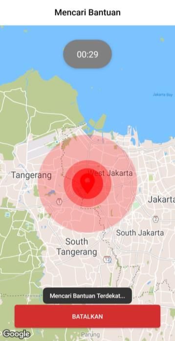
Gerzha Hayat Prakarsha et al / IJCTT, 69(2), 53-60, 2021

Maps as a travel map and directions, and real-time                 B. Haversine
location. This application also applies the Haversine
Algorithm to connect two closest user points within the                 This formula was first discovered by Jamez Andrew in
same radius. Haversine is an equation in navigation by             1805 and was first used by Josef de Mendozay Ríos in
giving a large circle distance (radius) between two points         1801. The term haversine itself was coined in 1835 by
on the surface of the sphere (earth) based on longitude and        Prof. James Inman. Josef de Mendoza y Ríos used
latitude [7].                                                      haversine for the first time in his research on "Major
     By using the Public Security Application, it is hoped         Astronomical Nautical Problems", Proc. Royal Soc, 22
that the assistance process can be made fast, precise, and         December 1796 [11]. One method for calculating the
safe. The community can press the emergency button                 distance of latitude-longitude points on the earth's surface
provided and the system will connect the community with            as a variable input is using the Haversine formula.
local security forces.                                             Haversine as a formula in navigation calculates the
                                                                   distance of a circle between latitude and longitude with
A. Research Problem                                                the assumption that the radius of R is 6367.45 km, and the
    How to build a public protection and security system           location of 2 points on the spherical coordinates (latitude
in an Android-based application using the Panic Button?            and longitude). The assumed Haversine formula ignores
How is the application of the Haversine Algorithm in a             the structure of the earth's surface (valley depth and
built application?                                                 hillside height), which is quite accurate for most
                                                                   calculations due to the fact that the earth is slightly
B. Object and Benefits                                             elliptical (ellipsoidal factor) [7]. Latitude is a line used to
                                                                   measure the distance between the north and south of the
    The purpose of the implementation of this research is          earth as opposed to the equator. Whereas longitude is a
to build an Android-based application to improve the               line used to measure the distance between the west and
protection and security of the community from all kinds
                                                                   east of the earth from the prime meridian [12]. About the
of emergency events that can harm or harm someone. This
                                                                   use of maps that already have two dimensions will have
application connects users with local security, which later
                                                                   points depicted in whole numbers. In the calculation step,
users can ask for help quickly and precisely.
                                                                   haversine is the first to convert the integer values of
C. Limitation of Research                                          latitude and longitude numbers into radians, then these
                                                                   numbers are calculated in the haversine algorithm [13].
    1. This application was developed in an Android-
        based environment using the application of the
        Haversine Algorithm.
    2. The application uses the Panic Button which can
        only be used a maximum of 1x (times) in 24
        hours and requires an internet connection.
    3. Users can only request and receive assistance
        when the User is within a predetermined radius
        and in the same area.
                                                                                 Figure 2.1 Haversine Formula
               II. STUDY LITERATURE
                                                                           cos (c) = cos (a− b) + sin (a) sin (b) cos (C)
A. Android Based Applications                                          In spherical units, a "triangle" on the surface of a
    The definition of an application is a program that             sphere is defined as the large circle connecting the three
people use to do something on a computer system.                   points u, v, and w on the sphere. If the lengths of the three
Android is a Linux-based operating system designed for             sides are (from u to v), b (from u to w), and c (from v to
touch screen mobile devices such as smartphones and                w), and the opposite point of view c is C [11].
tablet computers (Safaat, 2015). Android was originally            C. Panic Button
developed by Android, Inc., with financial support from
Google, which later bought it in 2005 [8]. Then in                   Panic Button is an emergency button located on an
November 2007 Google together with the Open Handset                Android-based application, used by Application users in
Alliance, namely the consortium of open mobile devices,            an emergency or urgent condition. This emergency button
released the Google Android SDK, after announcing it a             functions to send emergency information to fellow
week earlier and received a tremendous welcome. The                application users [14].
SDK software can be used to develop applications on
mobile devices, namely: Operating Systems, Middleware,             D. Google Maps API
and main applications for mobile devices [9]. Therefore,               Google Application Programming Interface (API) is a
most of the code from android is released on the open-             service provided to the public by Google Inc. released in
source Apache License, which means that anyone can                 2005. Google API products allow users to create
download the complete source code of the android                   applications according to developer needs [15]. Google
operating system [10].                                             Maps API, Google Maps provides the user with details
                                                                   about the geographic status of his location, details about

                                                              54
Gerzha Hayat Prakarsha et al / IJCTT, 69(2), 53-60, 2021

the surrounding buildings, the user's live location using
GPS, the traffic status of specific street navigation, etc.
For the development of new projects and commercial use
of other entities, google offers subscriptions to the service
map API [16]. In the Google Maps API, there are 4 types
of map model options provided by Google, including [17]:
     1. ROADMAP, to display 2-dimensional maps.
     2. SATELLITE, to display satellite photos.
     3. TERRAIN, to show the physical relief of the
         earth appearing to the surface and show how
         high a location is.
     4. HYBRID, will display a satellite photo on it also
         illustrates what appears on ROADMAP (street
         and city name)
E. Google Firebase Database
    Firebase is a web and mobile development platform.
Firebase uses can be found in many applications. Firebase
is traditionally used in applications that require fast
exchange and refresh of data. Chasapis, Mitropoulos, and
Douligeris (2019) discuss the advantages of using
Firebase. Among the many, it is possible to quickly add
more functionality to the application and to add cloud
functionality without the need for a dedicated backend
server [18]. Firebase Database is designed and developed
by Google, where different types of content depending on
the communication are available to design applications.                        Figure 3.1 Research Flow Diagram
The information is stored in the form of JavaScript                  B. System Analysis is Running
Notation Objects (JSON) in this database. Firebase Real-
time Database uses synchronization information which                      This research begins by visiting several housing
updates information every second and related instrument              estates located in Urban Village Petir, Tangerang City, to
are updated with new data synchronously according to the             conduct observations and interviews on the process of the
database [19]. Until recently on the internet, many                  community security system that has been running in the
databases were available except the main problem of                  housing complex, as well as conducting interviews with
databases is time. Most of the databases update their real-          the Head of Hamlets (RW) and the Head of the
time values with a duration of 15 seconds and so is not              Neighborhood (RT) or the housing management, security
sufficient to provide a decent result for every real-time            forces and the surrounding community to collect data and
value. But despite this weakness, Google's database is               determine the background to the problem.
better than other databases because here the real-time                    From the results of observations and interviews with
value updates within one second. Google Firebase                     related parties, the current stages of the business process
database is a free platform where all kinds of applications          during an emergency or people who need help, namely
(android, ios, web app) can be created, Firebase console             asking for help from the security forces (security guard)
platform provides many features, such as (push                       by contacting the security guard via telephone or chat or
notification, cloud messaging, database). Without paying             visiting the nearest security post. Furthermore, the
anyone can use their features. In the database, there are            security guard will come to the location in question to
mainly two types of databases, namely cloud fire stores,             provide assistance or assistance to the party asking for
and real-time databases. A real-time database is used to             help or residents of the housing. After that the security
store real-time values and a cloud Firestore is used for             guard reports to the Head of Hamlets (RW) and the Head
cloud messaging [20].                                                of the Neighborhood (RT) or the housing manager and the
                                                                     incident is recorded in the housing management report
       III. ANALYSIS AND DESIGN SYSTEM                               book.

A. Research Flow Diagram

   The Research Flowchart explains the stages of research
that the authors use to make this research.

                                                                55
Gerzha Hayat Prakarsha et al / IJCTT, 69(2), 53-60, 2021

C. Proposal System                                                   IV. APPLICATION OF THE HAVERSINE
                                                                                     FORMULA
                                                                A. Detect Point Area

              Figure 3.2 Proposal System
                                                                 Figure 3.3 Flow Chart Detect Point of User Location
D. Supporting Hardware and Software                                  The flow chart above describes a system that detects
a) Hardware                                                     the user's location using the Haversine Algorithm
                                                                calculation with the Area group around the User. The
    The hardware needed to support this application is a        User will automatically join the Area group around him if
smartphone with the following specifications:                   the User has previously joined the Area group. If the User
    - Minimum Intel Atom Quad-Core Z3580 Speed                  has not joined the Area group that is around him, the User
    2.3Ghz                                                      will be directed to create a new Area group or can search
    - Random Access Memory (RAM) with a minimum                 and join an existing Area group.
    capacity of 2 GB
    - Internal memory with a minimum capacity of 8 GB           B. Creating Area

b) Software
    The software used to complete reports and system
design includes:
    Windows Operating System, Android Operating
System, Android Studio, Firebase Realtime Database,
Draw.Io, and Lucid.app, Figma and Photoshop, Firebase
Notification, Github, and Node JS.

                                                                          Figure 3.4 Flow Chart Creating Area

                                                           56
Gerzha Hayat Prakarsha et al / IJCTT, 69(2), 53-60, 2021
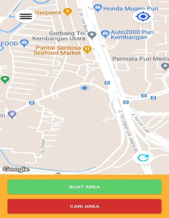
Users can create a new Area group that will be D. Haversine
determined radius distance with User point using
Haversine Algorithm calculation.
C. Feature Prompts Help
Figure 3.6 Haversine’s Algorithm
The flow diagram above is the Haversine Algorithm
which is used in several processes in the Public Security
Application.
E. Example of Calculating the Haversine Algorithm in
Applications
1. The formula for finding the nearest area to the
user's location point
a) First Coordinate Point (Area Point: GLC
Amerika Latin)
Latitude 1 = -6.1876
Longitude 1 = 106.7061
b) Second Coordinate Point (Users Near GLC
Figure 3.5 Flow Chart Feature Prompts for Help Amerika Latin)
Latitude 2 = -6.1884 /
In the search for help, the User will press the SOS Longitude 2 = 106.7059
button and provide some information regarding Radian (R) = 0.0174532925 (1 Radian)
emergency events. After that, the system will Radian Latitude1 (Rlatitude1) =
automatically wait for the location of the Security Party -6.1876 * 0.0174532925 = -0.107993992673
with a 600 radius in the Area group. If the secured party's Radian Longitude1 (Rlongitude1) =
location point is within a 50 radius of the user's location 106.7061 * 0.0174532925 = 1.86237277483425
point, the system will seek assistance from the security Radian Latitude2 (Rlatitude2) =
party using the Haversine Algorithm calculation. If not, -6.1884 * 0.0174532925 = -0.108007955307
the system will continue to search using the computation Radian Longitude2 (Rlongitude2) =
of the Haversine Algorithm. Furthermore, if the Security 106.7059 * 0.0174532925 = 1.86236928417575
Service is in a 600 radius the System Area group will D = acos (sin(Rlatitude1) * sin(Rlatitude2) +
issue a request for assistance and wait for assistance to be cos(Rlongitude1) * cos(Rlatitude2) * cos(Rlongitude2 −
received. If help is rejected or not received within 30 Rlongitude1)) * R
seconds the system will add a radius of +50 for the D = acos (sin(−0.107993992673) * sin(−0.108007955307)
Security Party search to the 600 radius limit. If you have + cos(1.86237277483425) * cos(1.86236928417575) *
not received assistance either, the system will display a cos(1.86237277483425−1.86236928417575)) * 6371
help message not received D = Radius: 92.00 meters = 0.092 kilometers
57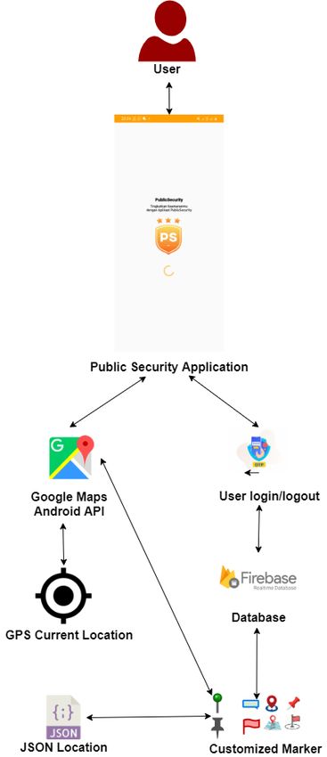
Gerzha Hayat Prakarsha et al / IJCTT, 69(2), 53-60, 2021

 Table 3.1 Example of Calculating the Haversine                  Table 3.2 Example of Calculating the Haversine
 Algorithm Finding the Area Closest to the User's              Algorithm Finding the Security Officer Nearest to the
                 Location Point                                               User's Location Point

                                                                   Locatio    Lati    Lo     Radia     Radian    Distance
Locati   Lat   Longi   Radi    Radia      Distanc                  n          tude    ngit   n         Longitu
on of    itu   tude    an      n          e                                           ude    Latitu    de
the      de            Latit   Longit                                                        de
Securi                 ude     ude                                 GLC        -       106    -         1.86237   Radius:
ty                                                                 Cluster    6.18    .70    0.107     277483    92.00
Guard                                                              Amerik     76      61     9939      425       meters =
GLC      -     106.7   -       1.8623     Radius:                  a Latin                   9267                0.092
Cluste   6.1   061     0.10    72774      92.00                                              3                   kilometer
r        876           799     83425      meters                                                                 s
                                                                   GLC        -       106    -         1.86227 Radius:
Ameri                  399                = 0.092
                                                                   Cluster    6.18    .70    0.108     503639 604.00
ka                     267                kilomet                  Asia       92      05     0219      625       meters =
Latin                  3                  ers                                                1794                0.604
                                                                                             1                   kilometer
GLC      -     106.7   -       1.8622     Radius:                                                                s
Cluste   6.1   005     0.10    75036      604.00                   GLC        -       106    -         1.86233 Radius:
r Asia   892           802     39625      meters                   Cluster    6.18    .70    0.107     088693 507.00
                       191                = 0.604                  Austral    44      37     9381      225       meters =
                                                                   ia                        4213                0.507
                       794                kilomet
                                                                                             7                   kilometer
                       1                  ers                                                                    s
                                                                   Metlan     -       106    -         1.86242 Radius:
GLC    -       106.7   -       1.8623     Radius:                  d Puri     6.19    .70    0.108     513471 785.00
Cluste 6.1     037     0.10    30886      507.00                              47      91     1179      175       meters =
r      844             793     93225      meters                                             1104                0.785
Austra                 814                = 0.507                                            975                 kilometer
lia                    213                kilomet                                                                s
                       7                  ers                      GLC        -       106    -         1.86225 Radius:
                                                                   Cluster    6.19    .69    0.108     758310 842.00
                                                                   East       25      95     0795      375       meters =
Metla    -     106.7   -       1.8624     Radius:                  Asia                      1380                0.842
nd       6.1   091     0.10    25134      785.00                                             625                 kilometer
Puri     947           811     71175      meters                                                                 s
                       791                = 0.785                 2.  The Formula for Finding         the Nearest Security
                       104                kilomet                     Officer
                       975                ers                       a) First Coordinate Point (A Security Guard’s Point
                                                                        Near GLC Amerika Latin)
                                                              Latitude 1        = -6.1876
GLC      -     106.6   -       1.8622     Radius:             Longitude 1       = 106.7061
Cluste   6.1   995     0.10    57583      842.00                    b) Second Coordinate Point (Users Near GLC
r East   925           807     10375      meters                        Amerika Latin)
Asia                   951                = 0.842             Latitude 2        = -6.1884
                       380                kilomet             Longitude 2       = 106.7059
                       625                ers                 Radian (R)        = 0.0174532925 (1 Radian)
                                                              Radian Latitude1 (Rlatitude1)       =
                                                               -6.1876 * 0.0174532925 = -0.107993992673
                                                              Radian Longitude1 (Rlongitude1) =
                                                              106.7061 * 0.0174532925 = 1.86237277483425
                                                              Radian Latitude2 (Rlatitude2)       =
                                                              -6.1884 * 0.0174532925 = -0.108007955307
                                                              Radian Longitude2 (Rlongitude2) =
                                                              106.7059 * 0.0174532925 = 1.86236928417575
                                                              D = acos (sin(Rlatitude1) * sin(Rlatitude2) +
                                                              cos(Rlongitude1) * cos(Rlatitude2) * cos(Rlongitude2 −
                                                              Rlongitude1)) * R

                                                         58
Gerzha Hayat Prakarsha et al / IJCTT, 69(2), 53-60, 2021
D = acos (sin(−0.107993992673) * sin(−0.108007955307) process and the application of the user interface process
+ cos(1.86237277483425) * cos(1.86236928417575) * according to the design.
cos(1.86237277483425−1.86236928417575)) * 6371 The application of the Haversine Algorithm in the
D = Radius: 92.00 meters = 0.092 kilometers Public Security Application is used to detect the user's
location point with the closest Area group, create Area
groups, and request the help of the nearest Security.
Answers to the Haversine Formula Combined with
Maximum Radius of Requesting Help
Distance between users and officers (PP distance) =
radius: 92.00 meters or 0.092 kilometers
Radius for Requesting Assistance (radiusMB): 50.00
Meters = 0.05 kilometers
If radiusMBGerzha Hayat Prakarsha et al / IJCTT, 69(2), 53-60, 2021
Furthermore, the User will be directed to the initial REFERENCE
view of the Area group page if the system succeeds in [1] A. Ratnasari and I. Ranggadara, COBIT 5 for Improving
Production Performance using DSS Domain, Int. J. Innov.
detecting the user's location point with the closest Area Technol. Explor. Eng., 9(4)(2020) 678–681 doi:
group and has previously joined the Area group. 10.35940/ijitee.c8619.029420.
[2] A. A. B. Ruíz, “No 主観的健康感を中心とした在宅高齢者における
健康関連指標に関する共分散構造分析Title, 3(2)(2015) 54–67, [Online].
Available: http://repositorio.unan.edu.ni/2986/1/5624.pdf.
[3] J. T. Santoso, M. C. Wibowo, B. Raharjo, and M. Mufadhol,
Gammu and kalkun for information services and sales based on
information technology, Int. J. Electr. Comput. Eng., 10(2)(2020)
2110–2116, doi: 10.11591/ijece.v10i2.pp2110-2116.
[4] BPS, Ht Tp S : // W W W . B . G, BPS, (Indonesian Stat., p.
Jakarta: Badan Pusat Statistik, (2019).
[5] M. Prawira, H. T. Sukmana, V. Amrizal, and U. Rahardja, A
Prototype of Android-Based Emergency Management Application,
2019 7th Int. Conf. Cyber IT Serv. Manag. CITSM (2019) doi:
10.1109/CITSM47753.2019.8965337.
[6] BPS, Statistik Kriminal 2019 Badan Pusat Statistik,1–218, (2019).
[7] E. Maria, E. Budiman, Haviluddin, and M. Taruk, Measure
distance locating nearest public facilities using Haversine and
Euclidean Methods, J. Phys. Conf. Ser., 1450(1)(2020) doi:
10.1088/1742-6596/1450/1/012080.
[8] N. C. Le, T. M. Nguyen, T. Truong, N. D. Nguyen, and T. Ngo, A
Machine Learning Approach for Real-Time Android Malware
Detection, Proc. - 2020 RIVF Int. Conf. Comput. Commun.
Technol. RIVF 2020, doi: 10.1109/RIVF48685.2020.9140771.
[9] M. R. Amin and M. Atiquzzaman, Behavioral Malware Detection
Approaches for Android, (2016).
[10] O. Mlouki, F. Khomh, and G. Antoniol, On the Detection of
Licenses Violations in the Android Ecosystem, 382–392, (2016)
doi: 10.1109/saner.2016.73.
[11] P. Dauni, M. D. Firdaus, R. Asfariani, M. I. N., Saputra, A. A.
Hidayat, and W. B. Zulfikar, Implementation of Haversine formula
Figure 4.3 Display Nearest Security Detection for school location tracking, J. Phys. Conf. Ser., 1402(7)(2019)
Requesting Help doi: 10.1088/1742-6596/1402/7/077028.
[12] M. Basyir, M. Nasir, S. Suryati, and W. Mellyssa, “Determination
of Nearest Emergency Service Office using Haversine Formula
In requesting help, the User can select the SOS button Based on Android Platform, Emit. Int. J. Eng. Technol., 5(2)(2018)
and provide some information regarding emergency 270–278, doi: 10.24003/emitter.v5i2.220.
[13] C. N. Alam, K. Manaf, A. R. Atmadja, and D. K. Aurum,
events. Furthermore, the system will automatically send a Implementation of haversine formula for counting event visitor in
request to the nearest Security Party starting from a 50 the radius based on Android application, Proc. 2016 4th Int. Conf.
radius from the user's location point. Cyber IT Serv. Manag. CITSM (2016) 2–7,doi:
10.1109/CITSM.2016.7577575.
VI. CONCLUSION [14] S. D. Damayanti, M. Suryanegara, and A. P. Button, Designing A
LoRa-Based Panic Button for Bali Smart Island Project, 2019 7th
Int. Conf. Smart Comput. Commun., 1–5, (2019).
Based on the research that has been done, the [15] N. G. Kalyanpad, C. K. Hanni, and K. V. K. Rao, “Mode Choice
following conclusions can be drawn: Analysis using Web-based Revealed Preference Questionnaire,
1. With the construction of a security system that helps Stated Preference Experiment and Google Maps API, Transp. Res.
Procedia, 48(2019) 3390–3400, (2020) doi:
connect Users with the Security Party, it can help 10.1016/j.trpro.2020.08.115.
every community who experiences an emergency and [16] P. Adhish, K. Abhijith, and S. R. M, Adaptive Traffic Light
can reduce the number of crimes. Control using Google Maps API at Multiple Road Intersections,
2. The application of the Haversine Algorithm is very Int. J. Eng. Adv. Technol., 9(2)(2019) 1802–1806, doi:
10.35940/ijeat.b2356.129219.
helpful in determining the radius to detect the closest [17] A. M. Luthfi, N. Karna, and R. Mayasari,Google maps API
Security Party or User. implementation on IOT platform for tracking an object using GPS,
3. The results of this study are expected to be developed Proc. - 2019 IEEE Asia Pacific Conf. Wirel. Mobile, APWiMob
into the IOS version and the website. 126–131, (2019) doi: 10.1109/APWiMob48441.2019.8964139.
[18] P. Tykal, D. Brnovik, and J. Landa, Creating a food menu
4. This application is also expected to be developed by application for mendel university in Brno, Acta Univ. Agric.
linking requests for assistance to relevant agencies Silvic. Mendelianae Brun., 68(1)(2020) 275–280, doi:
such as hospitals, police, fire departments, and so on. 10.11118/actaun202068010275.
So that the handling of emergency events that occur [19] A. Kumar Sharma and L. Mohan Saini, IoT based Diagnosing
Myocardial Infarction through Firebase Web Application, Proc.
in the community can be handled quickly and 3rd Int. Conf. Electron. Commun. Aerosp. Technol. ICECA (2019)
precisely. 190–195, doi: 10.1109/ICECA.2019.8822150.
5. Continuation of the development of this application [20] L. Goswami, Power Line Transmission through GOOGLE
can later be suggested using the addition of A-Star Firebase database, no. Icoei, 415–420, (2020).
[21] M.Nandha Kishore, A.Sridhar, S.Divakara, Advanced Security
Algorithm or DIJKSTRA Algorithm. Strategy in Smart E- Voting System, SSRG International Journal
of Computer Science and Engineering 2.6 (2015) 13-19.
60You can also read