Health Topic Paper Draft Drury-Opāheke Structure Plan 2019 Draft Pukekohe-Paerata Structure Plan 2019 - Auckland Council
←
→
Page content transcription
If your browser does not render page correctly, please read the page content below
Health Topic Paper
Draft Drury-Opāheke Structure Plan 2019
Draft Pukekohe-Paerata Structure Plan 2019
March 2019

Prepared by Elisabeth Laird and Jasmin Kaur, Plans and Places Department
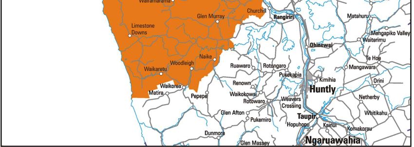
Table of Contents

1.     Executive Summary ......................................................................................................................3

2.     Introduction ...................................................................................................................................5

     2.1.    Purpose and scope of the report ............................................................................................5

3.     Health provision in Drury-Opāheke and Pukekohe-Paerata ..........................................................6

4.     Health and well-being outcomes of draft Drury-Opāheke and Pukekohe-Paerata Structure Plans
       10

     4.1.    Healthy cities and structure planning ................................................................................... 10

     4.2.    Draft Drury-Opāheke Structure Plan 2019 ........................................................................... 10

     4.3.    Draft Pukekohe-Paerata Structure Plan 2019 ...................................................................... 13

5.     Conclusion .................................................................................................................................. 16

6.     References ................................................................................................................................. 16

                                                                                                                                                      2
1. Executive Summary
Land use patterns and infrastructure influence how close we live to key services, the types of
recreation options or transit options available which in turn affects our health. As a structure plan sets
out the land use and infrastructure provision for an area, it will set out the urban environment for its
future inhabitants- as such it is an opportune time to assess potential impacts of proposals on health.
The purpose of this report is twofold. Firstly, it will summarise current health facility provision in the
Drury and Pukekohe structure plan areas. Secondly, it will provide a brief, high- level assessment of
possible health impacts from the draft Drury-Opāheke and Pukekohe-Paerata structure plans.
Drury and Pukekohe lie within the Counties Manukau District Health Board (CMDHB) area of care.
The CMDHB area extends from Ōtahuhu in the north to Waikaretu in the south (in Waikato District).
The socio-demographic mix of residents within the CMDHB area is diverse. The ethnic, income and
age mix within CMDHB presents issues such as access (i.e. cultural, financial) to health care
services, equity of services for different age, income groups, health promotion and disease prevention
amongst the population1. Demand for services within CMDHB is also growing at two per cent a year.
Under the Northern Region Long Term Investment Plan, an additional acute medical site is planned
for the CMDHB area. over the next 8-15 years. The aim is for this site to be fully operational in 20
years2.
Drury-Opāheke Structure Plan area
There are two medical practitioners within the Drury area. However, the wider hinterland of Drury-
Opāheke contain:
approximately six medical centres across Papakura, Takanini and Manurewa
four hospitals/ secondary health care facilities (i.e. Manukau Super Clinic, Middlemore Hospital,
Pukekohe Hospital and the Botany Super Clinic)
The Middlemore Hospital is the closest emergency care facility, which is a 15-20-minute drive and is
accessible by public transport.
The draft Drury-Opaheke Structure Plan promotes access to medical facilities through the provision of
the following zones:
town centre, local centre, neighbourhood centre (for general practitioner services)
residential – terraced housing and apartment building zone (for general practitioner services)
light industry zones can cater for larger health care centres.
Medical facilities can locate in these zones, subject to permitted standards in the Auckland Unitary
Plan.
Aside from medical facilities, the draft structure plan presents the following health and well-being
benefits:
two additional train stations connect residents to the region and reduces reliance on cars
enables local employment through the industry and centre zonings
the 20m riparian margins improve ecological health, biodiversity and water quality
1Counties Manukau District Health Board website: www.countiesmanukau.health.nz – Population composition
2 TheNorthern Regional Long Term Investment Plan was a collaboratively developed by the Auckland District Health Board,
Counties Manukau District Health Board, Waitemata District Health Board and the Northland District Health Board
provision of parks and open space at both neighbourhood and suburban/regional levels provides
opportunity for informal recreation
residential uses are in proximity to centres, will encouraging walking to access key services
clustering of land uses that could create boundary issues- i.e. heavy and light industry are located
together.
Pukekohe- Paerata Structure Plan area
There are approximately seven medical centres in the Pukekohe area, mostly clustered within the
existing town centre. There are four hospitals/ secondary health care facilities including the Pukekohe
Hospital, Manukau Super Clinic, Middlemore Hospital and the Botany Super Clinic. Aside from
Pukekohe Hospital, these major health facilities are located quite a distance from Pukekohe.
The draft Pukekohe-Paerata Structure Plan promotes access to medical facilities through the
provision of the following zones:
town centre, local centre, neighbourhood centre (for general practitioner services)
residential – terraced housing and apartment building zone (for general practitioner services)
light industry zones can cater for larger health care centres.
Medical facilities can locate in these zones, subject to permitted standards in the Auckland Unitary
Plan.
Aside from medical facilities, the draft structure plan presents the following health and well-being
benefits:
the additional train station and public transport services help residents access services within and
outside of, the structure plan area; and reduces the reliance on cars
enabling local employment through light industry and centre zonings
zoning to enable varying residential densities for housing choice
transit oriented developments as the highest densities are located by the train station
the 20m riparian margins improve ecological health, biodiversity and water quality
provision of parks and open space at both neighbourhood and suburban/regional levels provides
opportunity for informal recreation
clustering light industry zones to reduce potential for boundary effects.
However, in realising the health and safety benefits of these proposals, the implementation will be
important. Matters to be considered at plan change and development stages for both structure plans
include:
route morphology and convenience is considered when transport routes are designed to
enable walking from residential areas to key service destinations
pedestrian oriented design and route safety is considered for walking and cycling network
utilise the riparian margins and the 20m buffer for a walking and cycling network, where
possible.
4
2. Introduction
2.1. Purpose and scope of the report
A ‘Healthy Cities’ approach to urban planning3 recognises the role that spatial planning plays in the
health and well-being of residents. Land use patterns and infrastructure can influence how close we
live to key services, types of recreation options or transit options available which in turn affects the
health of its inhabitants.
In preparing any structure plan, Appendix 1 of the Auckland Unitary Plan requires a health impact
assessment to be conducted with a focus on environmental risk (i.e. air, land and water
contamination)4.
However, as a structure plan sets out the land use and infrastructure provision for an area, it will set
out the urban environment for its future inhabitants. It can dictate the exercise we do, the people we
meet, commuting time to work, school and leisure etc., which may affect our health.
The purpose of this health topic paper is twofold. It seeks to:
summarise current health provision in the Drury and Pukekohe structure plan areas.
provide a brief, high-level assessment of possible health impacts from the draft Drury-
Opāheke and Pukekohe-Paerata structure plans.
This paper is a rapid assessment of these draft structure plans from a health and well-being lens.
3 World Health Organisation website: http://www.who.int/life-course/partners/alliance-healthy-cities/en/ and WHO, 2009,
Zagreb Declaration for Healthy Cities http://www.euro.who.int/__data/assets/pdf_file/0015/101076/E92343.pdf
4 Appendix 1, Auckland Unitary Plan, S1.5(4c)
3. Health provision in Drury-Opāheke and Pukekohe-Paerata
3.1. Counties Manukau District Health Board
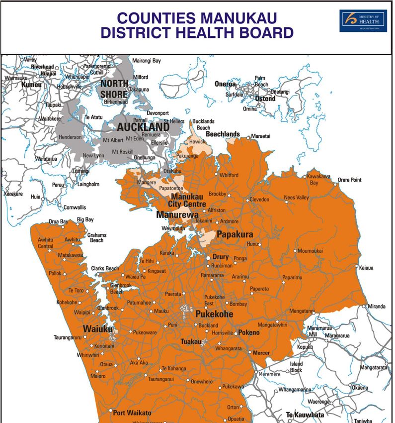
Drury and Pukekohe lie within the Counties Manukau District Health Board (CMDHB) area of care.
The CMDHB serves the Manukau, Manurewa, Pukekohe and Waiuku areas. It extends from Otahuhu
in the north to Waikaretu in the south and includes areas in the Waikato District.
The map below outlines the CMDHB area (Figure 1).
Figure 1: Counties Manukau DHB area.
To enable effective service delivery, the CMDHB area is divided into four localities – Mangere/Otara,
Eastern, Manukau and Franklin (see Figure 2).
6
The Drury-Opāheke structure plan area lies within the Manukau and Franklin localities and the
Pukekohe-Paerata structure plan area is sited within the Franklin locality (Figure 2).

                                                        Drury-Opāheke Structure Plan area

                                                Pukekohe-Paerata Structure Plan area

Figure 2: Counties Manukau District Health Board localities and the structure plan areas

Demographic composition of CMDHB residents

The Counties Manukau population is projected to grow at about two per cent annually, which is about
8-9000 residents each year5. The resident population of CMDHB is multi-ethnic with high numbers
and proportions of Māori (16% of CMDHB), Pacific (21% of CMDHB) and Asian (24% of CMDHB)
peoples6.

The ethnic mix of the CMDHB varies by age. Younger groups have higher populations of Maori,
Pacific and Asian peoples, while the population aged 65 years and over tend to identify with NZ
European/Other ethnic groups7.

At the 2016 census, approximately 36 per cent of the CMDHB population were living in areas classed
as most deprived8. This proportion is more likely to use CMDHB services because of the health
impacts of deprivation – i.e. poorer quality housing such as cold and damp conditions, possible
overcrowding etc.

Given this ethnic and age mix, issues such as access (cultural, financial etc.) to health care services,
equity, utilization of services, health promotion and disease prevention, arise.

5 Counties Manukau District Health Board website: www.countiesmanukau.health.nz – About us
6 Counties Manukau District Health Board website: www.countiesmanukau.health.nz – Population composition
7 Counties Manukau District Health Board website: www.countiesmanukau.health.nz – Population composition
8 Counties Manukau District Health Board website: www.countiesmanukau.health.nz – Socio-economic status
Research undertaken in 2010 indicated that CMDHB population did not appear to be accessing
primary care in proportion to their recognized health need9. In addition, amenable mortality, accounts
for 23 per cent of total death. Actions to reduce smoking prevalence, use of alcohol, and prevention
and management of cardiovascular risk factors are key areas to reduce amendable mortality10.
3.1.1. Health provision in the Drury-Opāheke area
In terms of general practices and primary health care, there are two medical surgeries within the
Drury area. There are approximately six medical centres further north of Drury – in Papakura,
Takanini and Manurewa. There is a late night medical centre in Franklin (south of Drury).
There are four hospitals/ secondary health care accessible to Drury residents, as follows:
Manukau Super Clinic
Middlemore Hospital
Pukekohe Hospital
Botany Super Clinic
The nearest is Manukau Super Clinic and Middlemore Hospital which is about a 15 to 20-minute
drive. Public transport (i.e. train) to Middlemore Hospital is approximately 45 minutes.
There is moderate provision in terms of primary care (i.e. general practitioner services). However, with
the growth in population envisioned for the area, this is likely to change. The train line and existing
motorway access connects Drury to hospitals and secondary health care provision.
3.1.2. Health provision in the Pukekohe-Paerata area
In terms of general practices and primary health care, there are approximately seven medical clinics
in the Pukekohe area, clustered within the existing town centre. There is a physiotherapist and a
radiology clinic as well.
Hospitals accessible within a 30 to 45 km driving distance includes:
Manukau SuperClinic: ~31km
Middlemore Hospital: ~38km
Botany SuperClinic: ~40-45km
Overall there is good access to primary and secondary health care from Pukekohe.
9CMDHB: Changes in Primary Health Care between 2001-2009 www.countiesmanukau.health.nz
10Life expectancy, leading causes of death and amenable mortality in Counties Manukau DHB, 2015
www.countiesmanukau.health.nz
8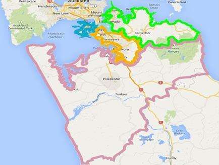
3.2. Longer term health care provision (Counties Manukau District Health Board)
The Northern Region Long Term Investment Plan (‘NRLTIP’)11, released in 2018, sets out the
strategic direction and investments for the ongoing delivery of health care in the DHB Northern
Region (Auckland and Northland). It is a 10 to 15-year plan, but considers a 25-year context for health
care planning.
In terms of facility provision, the NRLTIP investment path includes the following12:
To invest in current health care sites over the next 1-5-year timeframe.
To commission an additional acute site in the south (i.e. Counties Manukau DHB) over the
next 8-15 years and for this to be fully operational in 20 years. The new site would
predominantly serve the southern Counties Manukau population and may also be accessed by
some of the Waikato and Midland (central North Island) populations.
3.3. Analysis
Growth in the Drury-Opāheke and Pukekohe-Paerata area will increase demand for the medical
services in the CMDHB area. While the new acute facility in the south will add to supply of medical
facilities, it is unclear where this is likely to be located.
Drury-Opāheke is well-connected to existing medical clinics and facilities in CMDHB’s area, but
distance and access to these medical facilities is an issue.
The draft structure plans can provide for health care facilities in the following zones:
town centre, local centre, neighbourhood centre (for general practitioner services)
residential – terraced housing and apartment building zone (for general practitioner services)
light industry zones can cater for larger health care centres.
Medical facilities can locate in these zones subject to permitted standards in the Auckland Unitary
Plan.
11 Northland DHB, Waitemata DHB, Auckland DHB, Counties Manukau Health. Northern Region Long Term Investment
Plan, January 2018.
12 NRLTIP 2018, page 14 and 107
4. Health and well-being outcomes of draft Drury-Opāheke and Pukekohe-
Paerata Structure Plans
4.1. Healthy cities and structure planning
Aside from health facilities, the environment in which we live in affects our health and well-being. Air
pollution and water contamination have obvious effects on our health; but there are indirect effects of
our urban environment on our health. Our urban environment, including the layout, connections and
activities enabled by zoning regulations, can significantly impact the exercise we do, the people we
meet, commuting time to work, school and leisure etc.13
As structure plans set out the land use and infrastructure provision for an area, they will have an
impact on how close people live to key services, the types of recreation options or transit options
available, etc., and thus on their health.
The key structure plan proposals that have an impact on health and well-being are summarised
below.
4.2. Draft Drury-Opāheke Structure Plan 2019
4.2.1. Transport proposals
Public transport options contribute to transportation equity, as they allow people without access to a
car to move around easily14. A viable public transport network reduces car dependency which brings
financial benefits. It also reduces air pollution from car congestion.
Also, healthy cities15 are characterised by the ability to encourage incidental physical activity through
active transport (walking and cycling), which in is typically characterised by good land use mix and
higher densities.
The transport proposals in the draft Drury-Opāheke Structure Plan 2019 promote health and well-
being by supporting:
additional train stations at Drury West and Drury Central which can help reduce car reliance
public transport options to surrounding settlements, to reduce car reliance to access the Drury-
Opāheke area
walking and cycling routes along arterial roads and collector roads.
However, the health and safety benefits of these proposals will depend on how these proposals are
designed and implemented. Implementation of the structure plan should ensure:
that the conceptual blue-green network proposed for Drury-Opāheke can encourage walking and
cycling, particularly if these connect to key service destinations
pedestrian oriented design to encourage walking and cycling to access key destinations
route safety for walking and cycling networks – this includes vehicle speeds, separated cycling
networks, removing level crossings, and safety barriers and planting.
13 Barton, 2009
14 Sarker, et al, 2014
15 RTPI, 2014
104.2.2. Land use proposals – residential, centres and industrial land
The land uses (i.e. zones) available and its configuration significantly impacts health and well-being.
For instance, the potential for local employment is important for health. Income and employment are
important indicators of health and well-being16. Long travel times between home and work can be
stressful and leaves less time available for recreation and leisure. Land uses and transport networks
should be designed to ensure a wide range of employment, retail, commercial services and
community facilities can be accessed within a reasonable distance/ timing. Congestion also
contributes to poorer air quality.
Land use proposals are also important for service accessibility. Service accessibility is the proximity of
residential areas to key services (i.e. retail, food, health care, education, green space, sports etc.) 17.
Poor connections and inadequate access to services exacerbates inequality, social exclusion and
poor health.
The configuration of land uses plays a role in well-being. For instance, heterogeneous land use (i.e.
mix of land uses) enables a mix of activities and services, i.e. retail, shops, recreation, healthcare,
schools etc. to be in proximity of each other. At higher densities, these activities and services are
close enough together to encourage walking and cycling18. Proximity to potential amenities is an
important predictor of walking.
Through its land use proposals, the Draft Drury-Opāheke Structure Plan 2019 improves health and
well-being by:
providing for a range of employment options – centres, light and heavy industry enable a mix of
businesses and potential jobs for Drury-Opāheke and for the region
providing for a large to small centres to provide key service needs that will encourage self-reliance
and reduce the need to travel out of Drury-Opāheke to access services
providing for a range of residential densities and therefore residential choice
locating residential uses in proximity to centres, i.e. higher density residential close to larger
centres, and locating smaller centres through low and medium density residential areas, will
encourage walking and cycling to meet service/retail needs
clustering key service destinations (i.e. locating larger centre close to the proposed train stations),
encourages walking and cycling as key services are in proximity of each other.
However, in realising the health and safety benefits of these land use proposals, the implementation
will be important. Matters to consider at the detailed implementation stage include:
route morphology and convenience in connecting residential areas to key service destinations –
that is, direct, safe routes that will encourage walking and cycling to destinations.
urban design at the neighbourhood level – this includes good accessibility around neighbourhood,
the street scape, accessible and quality public spaces etc.19
potential boundary effects from light and heavy industry located in proximity to residential land
uses.
potential contamination effects to soil and waterways from urban activities.
The latter matters are detailed in Section 4.2.3 below.
16 Barton, page 119
17 Handy et al, 2006 in Sarkar et al, page 102
18 Sarker, et al, 2014, page 102
19 RTPI, 20144.2.3. Managing hazards, contamination and reverse sensitivity
Pollution and boundary effects can have a profound impact on health and well-being. Hazards can
present a risk to life and should be considered as part of structure planning.
Appendix 1 of the Auckland Unitary Plan requires structure plans to consider the health impacts of
possible pollution, contamination and impacts reverse sensitivity (often associated with boundary
effects). Boundary effects are when two incompatible zones are adjacent and noise, dust, vehicle
movements, smells, can negatively impact on health and well-being.
Flood hazards are the most prominent risk associated with urban development in Drury-Opāheke.
There are significant floodplains associated with the major stream catchments that run through the
area.
The Draft Drury-Opāheke Structure Plan 2019 considers hazards, contamination and boundary
effects by:
precluding sensitive urban land uses in floodplains.
clustering land uses that have the potential to create issues, to minimise potential reverse
sensitivity effects; e.g. clustering light and heavy industrial near existing industrial zones.
identifying areas of potential contamination and requiring further investigation and possibly
remediation20 at the plan change or resource consent stages of development.
At the development stages (i.e. plan changes or resource consent stages) of Drury-Opāheke, the
following could be considered to enable positive health and well-being outcomes. This includes:
buffering through planting or infrastructure (i.e. roads, cycleways etc.) between industrial activities
and residential areas in some part of the Drury-Opāheke Structure Plan area.
4.2.4. Parks, green network and open space
Accessible recreational or physical activity opportunities are the best way to complement an
individual’s effort to stay active and healthy21. A study on the proximity of recreation opportunities
found that the density of physical activity resources within a neighbourhood increased odds of
individuals partaking in physical activity22. Affordable recreational opportunities had better health
outcomes, as these further increases the odds of physical activity23.
The proposals for parks and open space within the Drury-Opāheke Structure Plan area enhances
health and well-being by:
locating neighbourhood or suburban parks within walking distance of residential areas, which
increases the opportunity for more informal recreational activity
providing for sports parks for sporting activities and events
20 As required by the Resource Management Act 1991
21 Sarkar et al 2014, page 107
22 Sarker et al 2014, page 108-109
23 Sarkar et al 2014, page 107
12 proposing 20m riparian margins along all permanent and intermittent streams, which can help
improve water quality, stream health and biodiversity, and which can provide additional green
spaces
proposing a blue-green network to enhance walking and cycling.
However, the health benefits of these proposals will depend on how these proposals are designed
and implemented. Implementation of the structure plan should consider:
complement proposed greenways and paths plans developed by the local board.
enabling walking and cycling along the riparian margins where possible.
4.3. Draft Pukekohe-Paerata Structure Plan 2019
4.3.1. Transport proposals
Public transport options contribute to transportation equity, as they allow people without access to a
car to move around easily24. A viable public transport network reduces car dependency which brings
financial benefits. It also reduces air pollution from car congestion.
Also, healthy cities25 are characterised by the ability to encourage incidental physical activity through
active transport (walking and cycling), which in is typically characterised by good land use mix and
higher densities.
The transport proposals in the Draft Pukekohe-Paerata Structure Plan 2019 promote health and well-
being by supporting:
an additional train station at Paerata which can help reduce car reliance
expanded local public transport coverage across the structure plan area to reduce car reliance
walking and cycling routes along arterial roads and the collector road network which can
encourage active transport.
However, the health and safety benefits of these proposals will depend on how these proposals are
designed and implemented. Implementation of the structure plan should ensure:
the walking/ cycling, public transport network facilitates direct connections to key public transport
stations/interchanges
pedestrian oriented design to encourage walking and cycling to access key destinations
route safety for walking and cycling networks – this includes vehicle speeds, separated cycling
networks and removing level crossings
that the green network proposed for Pukekohe-Paerata is connected across the structure plan
area and connects to key service destinations.
4.3.2. Land use proposals – residential, centres and industrial land
The land uses (i.e. zones) available and their configuration significantly impacts health and well-being.
For instance, the potential for local employment is important for health. Income and employment are
important indicators of health and well-being26. Long travel times between home and work can be
stressful and leaves less time available for recreation and leisure27. Land uses and transport networks
24 Sarkar et al. 2014
25 RTPI, 2014
26 Barton, page 119
27 Synergia, 2009 and RTPI, 2014should be designed to ensure a wide range of employment, retail, commercial services and
community facilities can be accessed within a reasonable distance/ timing. Congestion also
contributes to poorer air quality.
Land use proposals are also important for service accessibility. Service accessibility is the proximity of
residential areas to key services (i.e. retail, food, health care, education, green space, sports etc.) 28.
Poor connections and inadequate access to services exacerbates inequality, social exclusion and
poor health.
The configuration of land uses plays a role in well-being. For instance, heterogeneous land use (i.e.
mix of land uses) enables a mix of activities and services, i.e. retail, shops, recreation, healthcare,
schools etc. to be in proximity of each other. At higher densities, these activities and services are
close enough together to encourage walking and cycling29. Proximity to potential amenities is an
important predictor of walking.
Through its land use proposals, the draft Pukekohe-Paerata Structure Plan 2019 improves health and
well-being by:
providing for a range of employment options through centres and light industry zones
providing for a range of residential densities and therefore residential choice
enabling higher density housing near the proposed Paerata train station which can reduce car
reliance and public transport use
locating lower density housing in ecologically sensitive areas, including areas near floodplains.
However, in realising the health benefits of these land use proposals, the implementation will be
important. Matters to consider at the detailed implementation stage include:
route morphology and convenience in connecting residential areas to key service destinations –
that is, direct, safe routes that will encourage walking and cycling to destinations
urban design at the neighbourhood level – this includes good accessibility around neighbourhood,
the street scape, accessible and quality public spaces etc.30
potential boundary effects from two incompatible zones locating adjacent to each other – e.g. light
industry and residential areas.
4.3.3. Managing hazards, contamination and reverse sensitivity
Pollution and boundary effects can have a profound impact on health and well-being. Hazards can
present a risk to life and should be considered as part of structure planning.
Appendix 1 of the Auckland Unitary Plan requires structure plans to consider the health impacts of
possible pollution, contamination and impacts reverse sensitivity (often associated with boundary
effects). Boundary effects are when two incompatible zones are adjacent and noise, dust, vehicle
movements, smells, can negatively impact on health and well-being.
Flood hazards are the most prominent risk associated with urban development in Pukekohe –
Paerata. There are floodplains associated with the three major stream catchments that run through
the area.
28 Handy et al, 2006 in Sarkar et al, page 102
29 Sarker, et al, 2014, page 102
30 RTPI, 2014
14The Draft Pukekohe-Paerata Structure Plan 2019 considers hazards, contamination and boundary
effects by:
clustering land uses that have the potential to create issues, in order to minimise potential reverse
sensitivity effects; e.g. clustering light industrial near or on sites that have existing commercial
use.
identifying areas of potential contamination and requiring remediation31 at the plan change and
resource consent stages of development.
At the development stages (i.e. plan changes or resource consent stages) of Pukekohe-Paerata, the
following could be considered to enable positive health and well-being outcomes. This includes:
buffering through planting or infrastructure (i.e. roads, cycleways etc.) on the edge of the rural
urban boundary, along strategic transport routes, and between residential and industrial land
uses.
4.3.4. Parks, green network and open space
Accessible recreational or physical activity opportunities are the best way to complement an
individual’s effort to stay active and healthy32. A study on the proximity of recreation opportunities
found that the density of physical activity resources within a neighbourhood increased odds of
individuals partaking in physical activity33. Affordable recreational opportunities had better health
outcomes, as these further increases the odds of physical activity34.
The proposals for parks and open space within the Pukekohe-Paerata Structure Plan area enhances
health and well-being by:
locating neighbourhood parks (0.3ha to 0.5ha) within walking distance of residential area, which
increases the opportunity for informal physical activity
proposing suburban parks and sports parks to provide recreation options for the area
proposing 20m riparian margins along all permanent and intermittent streams, which can help
improve water quality, stream health and biodiversity, and which can provide additional green
spaces.
However, the health and safety benefits of these proposals will depend on how these proposals are
designed and implemented. In implementing the structure plan, the following should be considered:
complement proposed greenways and paths plans developed by the local board
enabling walking and cycling along the riparian margins where possible.
31 As required by the Resource Management Act 1991
32 Sarkar et al 2014, page 107
33 Sarkar et al 2014, page 108-109
34 Sarkar et al 2014, page 1075. Conclusion
The key health and well-being benefit of the Drury-Opāheke and Pukekohe- Paerata Structure Plans
is the access it will provide through the proposed train station and public transport. It will enable
access to employment, healthcare, education and the services offered in the region.
Other key health and well-being benefits include:
locating parks and centres in proximity to residential areas
enabling zoning for business and employment
riparian buffers along the streams to filter contaminants and protect the integrity of the streams.
However, in the implementation of the draft structure plans, matters such as connectivity across the
structure plan area- i.e. pedestrian oriented design, connecting key service destinations through
walking and cycling; can further strengthen these draft plans from a health and well-being
perspective.
6. References
American Planning Association, 2016, Health Impact Assessments- a toolkit for planners,
Auckland District Health Board; Counties Manukau District Health Board, Northland District Health
Board and Waitemata District Health Board, 2018, Northern Region Long Term Investment Plan,
http://www.adhb.health.nz/assets/Uploads/20181018-NRLTIP-Slidepack-FINAL2.pdf
Barton, H, 2009, Land use planning and health and well-being, in Land Use Policy, 26S, pg S115-
S123
Royal Town Planning Institute, 2014, Promoting Healthy Cities- Why planning is critical to a healthy
urban future, https://www.rtpi.org.uk/media/1119674/rtpi_promoting_healthy_cities.pdf
Sarkar, C; Gallacher, J; Webster, C, 2014, Healthy Cities- public health through urban planning,
Edward Elgar Publishers, Cheltenham
16Find out more: phone 09 301 0101
You can also read