Human footprints from Italy: the state of the art - Journal of ...
←
→
Page content transcription
If your browser does not render page correctly, please read the page content below
Journal of Mediterranean Earth Sciences 12 (2020), xx-xx
doi: 10.3304/JMES.2019.003 In: Romano M., Citton P. (Eds.), Tetrapod ichnology in Italy: the state of the art
Journal of Mediterranean Earth Sciences
Human footprints from Italy: the state of the art
Marco Avanzini 1,*, Paolo Citton 2, Paolo Mietto 3, Adolfo Panarello 4, Pasquale Raia 5,
Marco Romano 6, Isabella Salvador1
1
MUSE, Museo delle Scienze, Trento, Italy
2
IIPG, Instituto de Investigación en Paleobiología y Geología (CONICET), General Roca, Río Negro, Argentina.
3
Dipartimento di Geoscienze, Università di Padova, Padova, Italy
4
Laboratorio di Ricerche Storiche e Archeologiche dell’Antichità, Dipartimento di Scienze Umane, Sociali e della Salute,
Università di Cassino e del Lazio Meridionale, Cassino, Italy
5
Dipartimento di Scienze della Terra, dell’Ambiente e delle Risorse, Università di Napoli Federico II, Napoli, Italy
6
Dipartimento di Scienze della Terra, Sapienza Università di Roma, Roma, Italy
* Corresponding author: marco.avanzini@muse.it
ABSTRACT - The ichnological record of human traces from Italy is rich and quite diversified. In recent years, the
development and dissemination of various methodologies and technological applications has facilitated the re-analysis
of this record, enabling different, sometimes deeper, interpretations favoured by the integration of external data, both
geological and palaeontological. The oldest occurrence of the human ichnological record from Italy is represented by
the Middle Pleistocene ‘Devil’s Trails’ ichnosite in the “Foresta” area (Roccamonfina volcano, southern Italy), depicting
human trackmakers trampling a pyroclastic flow deposit while descending a slope dating to about 349 ka. Most of the
record is Holocene in age and is constituted by the Upper Palaeolithic Grotta della Bàsura site (Toirano, northern Italy,
about 14 ky), the protohistoric sites of Afragola, Nola and Palma, the area of Pompei and the site of Aosta. The record
is enriched by the ichnological evidence preserved in military structures of Trentino region (northern Italy) during the
First World War. An updated report and discussion of these sites is provided here.
Keywords: human footprints; Pleistocene; Holocene.
Submitted: 11 February 2020-Accepted: 10 March 2020
1. INTRODUCTION archaeological and historical contexts of the most diverse
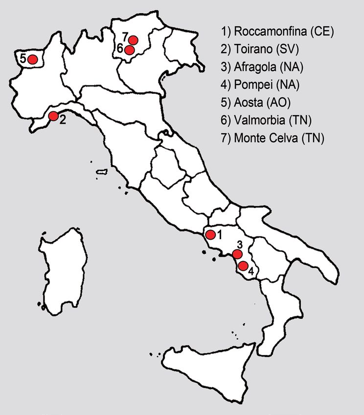
areas and ages (Avanzini, 2011) (Fig. 1).
The first study devoted to human fossil footprints in
Italy was due to Leon Pales (Blanc et al., 1960) who, in 2. THE PLEISTOCENE RECORD
the middle of the 19th century, analysed the Palaeolithic
fossil footprints of the Grotta della Bàsura near Savona. 2.1. THE ‘DEVIL’S TRAILS’ ICHNOSITE (ROCCA-
Despite the frequent presence of human traces in MONFINA VOLCANO, CASERTA, SOUTHERN
archaeological contexts of Roman and medieval Ages (i.e. ITALY)-MIDDLE PLEISTOCENE
Acocella, 2013; Giorgetti and González Muro, 2011; De The oldest evidence of human footprints from Italy is
Vos and Maurina, 2011), the study of this type of traces represented by the well-known ‘Devil’s Trails’ ichnosite
played secondary role for decades. Only in 2003, after the at Tora e Piccilli (“Foresta” area, Roccamonfina volcano,
correct interpretation by Marco de Angelis and Adolfo Caserta province, southern Italy) (Fig. 1). The ichnosite,
Panarello of the prints impressed on the ignimbrite of the formally described by Mietto et al. (2003), was already
Roccamonfina volcano near Caserta, the interest in this known by local people since the first half of XIX century
discipline has been renewed (Mietto et al., 2003). (Panarello, 2005; De Angelis, 2009; Panarello et al.,
In recent years, the attention to this type of finds has 2017a). The record consists of many footprints preserved
undoubtedly increased and the identification of new on a volcanic deposit so as to evoke, over time, various
sites is linked to the review of historical ones. The use of fantastic and anecdotal interpretations about an uncanny
modern investigative approaches led the re-examination walker able to cross fresh lava without getting burnt
of old finds and expanded the study of human traces in (hence the name “ciampate del diavolo”, literally translated
32                                  M. Avanzini et al. / Journal of Mediterranean Earth Sciences 12 (2020), xx-xx

                                                                             2.1.1. Geographic and geological settings
                                                                                The “Ciampate del diavolo” site is located on the
                                                                             northeastern slope of the Roccamonfina volcano
                                                                             (N41°19.954’-E14°01.488’) in the Roman Comagmatic
                                                                             Province (Appleton, 1972). The geological evolution of the
                                                                             Roccamonfina volcano comprises several activity phases
                                                                             (Giannetti, 1979a, 1979b; Radicati di Brozolo et al., 1988;
                                                                             Cole et al., 1992; De Rita and Giordano, 1996; Rouchon et
                                                                             al., 2008 and references therein). The ichnological record
                                                                             refers to the end of the first phase, when, between 0.385
                                                                             and 0.335 Ma, a thick ignimbritic succession, known as
                                                                             “Brown Leucititic Tuff ” (BLT - Luhr and Giannetti, 1987;
                                                                             Ballini et al., 1989a) was deposited on the slope of the main
                                                                             stratocone. The human and animal tracks are preserved
                                                                             at the top of the LS07 (sensu Santello, 2010) within the
                                                                             BLT (Avanzini et al., 2008; Santello, 2010; Panarello et
                                                                             al., 2017a, 2020), which is exposed for approximately
                                                                             2000 m2. According to Mietto et al. (2003), zeolitization
                                                                             (low temperature mineral neoformation) of the trampled
                                                                             deposits led to the lithification of the surface, thus enabling
                                                                             the preservation of the footprints. These were in turn
                                                                             covered by coarser, granular material belonging to the
Fig. 1 - Localization of the main sites with human footprints in             LS08 which further contributed to footprints fossilization
Italy. 1) ‘Devil’s Trails’ ichnosite (Roccamonfina volcano, Caserta);        (Santello, 2010; Panarello, 2016a, 2016b, 2020).
2) Grotta della Bàsura (Bàsura Cave) site, Toirano (Savona); 3)
                                                                                The first dating of LS07 based on K/Ar method provided
Afragola, Nola and Palma Campania (Napoli); 4) Pompei Area
(Napoli); 5) Aosta; 6) Valmorbia (Trento); 7) Celva Mount (Trento).
                                                                             an age of 385-325 ka (Appleton, 1972; Giannetti, 1979a,
                                                                             1979b; Luhr and Giannetti, 1987; Radicati of Brozolo et
                                                                             al., 1988; Ballini et al., 1989a, 1989b, 1990; Cole et al.,
                                                                             1992; De Rita and Giordano, 1996). Subsequently, Scaillet
into “devil’s footprints” or “devil’s trails”; Avanzini et al.,              et al. (2008) used the 40Ar/39Ar method providing a dating
2008; Panarello et al., 2017b), or an ancient warrior of                     of 345±6 ka. The last available and probably best-accurate
historic times (Iulianis, 1986).                                             estimate is given by Santello (2010), which dated the
   The record represented, for at least a decade, the oldest                 trampled layer at 349±3 ka. According to this age, the
occurrence in the global human ichnological record,                          ichnosite results a little bit younger than Termination IV
leading to a great scientific and media interest (Avanzini,                  and referable to the late MIS 10 (Panarello et al., 2017a,
2003; Avanzini et al., 2003, 2008; Mietto, 2004, 2009;                       2020).
Mietto et al., 2013; Panarello, 2016a, 2016b; Panarello
et al., 2017a, 2017b, 2018, 2020; Palombo et al., 2018;                      2.1.2. Ichnology
Saborit et al., 2019). Recently, evidence for older human                       After the first report stressing the global significance of
footprints (likely referable to Homo herectus) have been                     the Roccamonfina site (Mietto et al., 2003), subsequent
described from Ileret/Koobi Fora in Kenya (Bennett et al.,                   field work was conducted between 2005 and 2010,
2009), at Happisburgh in the United Kingdom (Ashton                          enriching the record from the village of “Foresta”
et al., 2014), at Gombore II.2 - Melka Kunture, Africa                       (municipality of Tora e Piccilli, Caserta province) with
(Altamura et al., 2018). The human-like footprints from                      other evidences of human frequentation, some of which
the Miocene of Trachilos (Crete, Greece) could have been                     are still under study (Panarello et al., 2017a) (Fig. 2).
produced by an ape that convergently evolved human-                             Originally, at least 46 footprints and a single possible
like foot anatomy (Gierliński et al., 2017).                                 handprint organized in three trackways (A, B, C) were
   The first ichnological survey in the ‘Devil’s Trails’                     recognized together with other animal traces. 14 new
ichnosite showed the existence of at least three main                        human footprints have been recently announced from
trackways, which were imprinted on a zeolite-rich deposit                    the site raising the total number of human traces to 81.
produced by a pyroclastic flow originally dated at 385,000-                  These new findings allowed for the identification of
325,000 years ago. However, a new trackway and two                           another human trackway (called Trackway E) (Panarello
other possible directions of walking have been recently                      et al., 2020).
announced raising the number of human trackways                                 A first detailed description of three main trackways,
at least to four (Panarello et al., 2020). Moreover, some                    named ‘Trackway A’, ‘B’ and ‘C’ was given in Avanzini
stone tools have been found within the site and in its close                 et al. (2008). Trackway A is made of 26 footprints on a
surroundings (Panarello et al., 2017a, 2020).                                total length of 13.40 m. Footprints depict an individual
                                                                             descending a very steep slope by crossing it through a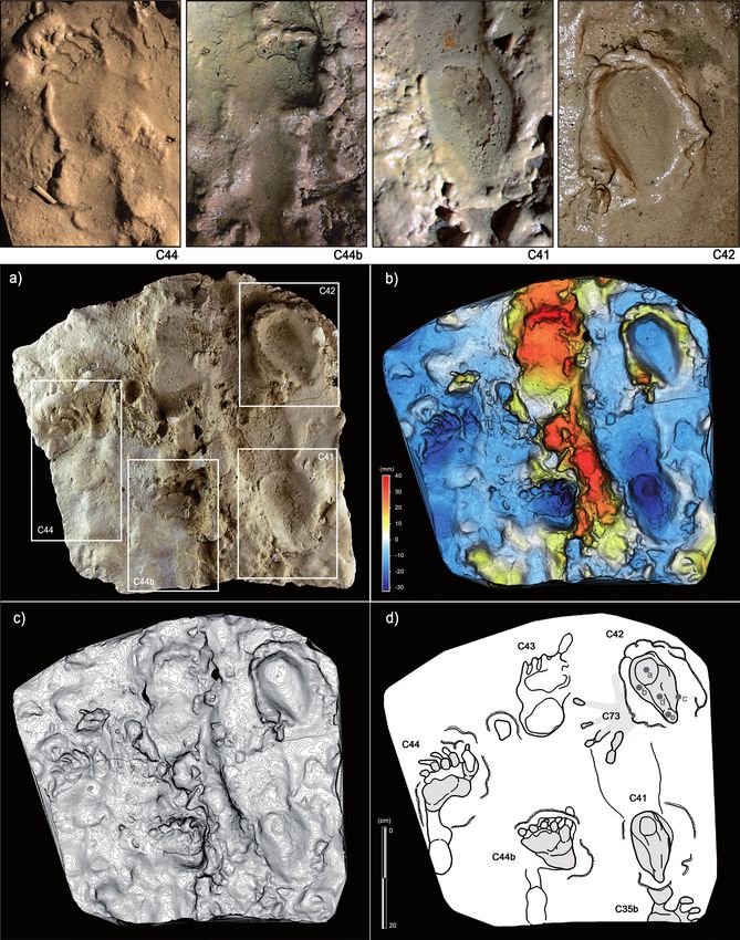
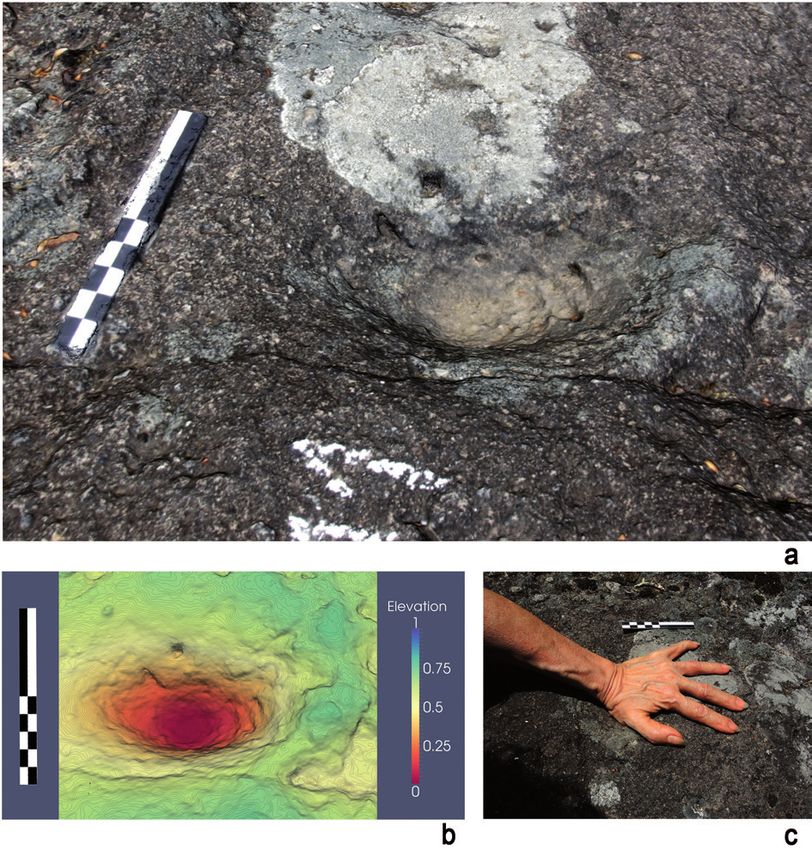
M. Avanzini et al. / Journal of Mediterranean Earth Sciences 12 (2020), xx-xx                       33

Fig. 2 - Foresta “Devil’s Trails” ichnosite: southern overview of the trampled BLT-slope; a) Western overview of the prehistoric pathway
P1; b) South-eastern view of Trackway A; c) South-eastern view of Trackway B; d) Western view of the segment 2C of Trackway C
(scale-bar: 2 m); e) Eastern oblique 3D generated photo of Trackway E (scale-bar: 10 cm); f) Southern oblique 3D generated detail
photo of the footprint B11 (left) preserving all the parts of a leg (calf, ankle an foot) (scale bar: 10 cm).

34                              M. Avanzini et al. / Journal of Mediterranean Earth Sciences 12 (2020), xx-xx

Z-shaped path, probably to choose the steadiest and most                 Foresta trackmakers. Nonetheless, the shape and the
convenient gradient (Mietto et al., 2003; Avanzini et al.,               dimensional range of the human footprints of Foresta
2008; Saborit et al., 2019).                                             allow us to suppose that the hominins who walked on
   Trackway B consists of 19 footprints and a single                     the Roccamonfina volcano slopes during the Middle
handprint and has a total length of 8.60 m (altitude                     Pleistocene were part of human populations widely
difference of 2.91 m); looking at the spatial disposition                diffused in southern Latium and shared some anatomical
of the tracks, it seems that the producer placed its own                 features with the Sima de los Huesos hominins (Panarello
feet in a more irregular manner than occurred during the                 et al., 2020 and references therein).
impression of the ‘Trackway A’; moreover, footprints show                   More recently, further studies devoted to taphonomy,
slipping traces very likely indicating that the individual               associated palaeoichnofauna and archaeology have been
descended the slope in a less deliberate manner (Avanzini                undertaken (Panarello et al., 2017a). The associated
et al., 2008).                                                           palaeoichnofauna is characterised by different tracks
   Trackway C was recently reinterpreted (Panarello et                   preserved on the sub-horizontal surface also trampled
al., 2020); the trackway is 10.6 m long and is composed                  by humans (Panarello et al., 2017a). These tracks were
of 13 human footprints composing two quite-straight                      referred to middle sized ruminant artiodactyls and
segments, which are separated by a rupture of the ground                 possible young strait-tusked elephants (Panarello et al.,
extending for about 5.59 m.                                              2017a; Palombo et al., 2018).
   Trackway E was described for the first time in Panarello                 Panarello et al. (2017b) described the additional P1-
et al. (2020). It is composed by four human footprints in                Trackway located on the top of the same BLT (Brown
regular right/left succession and has a total length of 1.10             Leucitic Tuff, top of layer LS7) zeolitized layer preserving the
m and a maximum width of about 17 cm. Trackway E                         above described footprints, and representing the area from
indicates movement toward the west, which is in an                       which the two trackways A and B start. The fossil pathway,
opposite direction to all the others.                                    called P1-Pathway (start: N41°19.954’-E14°01.466’, ends:
   Trackways A, B and C are narrow and almost constant                   N41°19.962’-E14°01.496’), subdivided by the authors into
with respect to the pace and stride length, respectively                 25 different segments, is characterised by a total length
equal to 60 cm and 120 cm. The stride length/footprint                   of ~53.19 m, showing a total width ranging from 1.40 m
length ratio equals to 5. Footprints indicate both inward                to a maximum of 3.21 m and registration across an area
and outward foot rotation with respect to the trackway                   with an altitude varying from 292±3 m a.s.l. at the start
midline (i.e. foot angle), with values ranging from -5°                  (west) to 283±3 m a.s.l. (east). The authors recognized
to 20°, and a pace angulation ranging between 90° (final                 on the surface several superimposed human traces, some
portion of Trackway A) and 160°, this last value mainly                  of which referable to the footprints forming trackways A
characterising trackways B and C (Avanzini et al., 2008).                and B, followed by a post-lithification smoothing of the
In Trackway E the average measurable step and stride are,                traces linked by Panarello et al. (2017b) to the passage of
respectively, 34.17 cm and 69.5 cm (Panarello et al., 2020).             both human and animals and, in historical times, to the
   From a morphological and functional standpoint,                       quarrying activities and frequent foot traffic across the
footprints are plantigrade, entaxonic, with an average                   site. Based on an analysis of the global record, Panarello
length of about 24 cm and an overall width of about 10                   et al. (2017b) considered P1-Pathway as the oldest known
cm, thus appearing relatively short and broad (Avanzini                  human “pathway” in the world.
et al., 2008). The footprint E3 (Trackway E) is almost                      After the reports by Mietto et al. (2003) and Avanzini
completely preserved and has a total length of 27 cm                     et al. (2008), which interpreted the purported handprint
(Panarello et al., 2020).                                                (TP_M1; Trackway B) as an intervention of the left
   Adopting a ratio equal to 15.5% and the available                     arm to regain lost balance when sliding in the soft
formulas for stature estimate (Grieve and Gear, 1966;                    substrate, Panarello et al. (2018) re-analysed the track
White, 1980; Charteris et al., 1982), Avanzini et al. (2008)             by means of high-resolution Digital Photogrammetry.
ascribed the footprints of Trackways A, B and C to adult                 The hand-print was interpreted as fully compatible
individuals no taller than 1.56 m, walking at an average                 with those characterising actual human hands. Based
speed of 1.09 m/s (based on the method of Alexander,                     on general morphology and print length and width, the
1984). The footprints of Trackway E seem left by a taller                material corresponds well to the variability detected in
individual (Panarello et al., 2020), resulting 174.2 cm tall.            anthropometric values for both Pleistocene hominins
   Based on Homo fossil remains from the region (i.e. the                and present day humans (Mc Henry, 1992; Marzke and
Ceprano skull; Ascenzi et al., 1996, 2000; Manzi et al., 2000,           Marzke, 2000; Buryanov and Kotiuk, 2010; Garrido Varas
2010; Manzi, 2016; Di Vincenzo et al., 2017), Panarello et               and Thompson, 2011; Almécija et al, 2015; Darowish et
al. (2017a) considered that very likely the Roccamonfina                 al., 2015; Lorenzo et al., 2015) and correlates very well
footprints could be attributed to an European Middle-                    with previous stature estimates (Avanzini et al., 2008;
Pleistocene form like Homo heidelbergensis. Today, based                 Panarello et al., 2018). Thus in conclusion, the study
on a renewed debate about the precise characterization                   confirms the original interpretation of the TP_M1
of Homo heidelbergensis, it seems to be more correct                     hollow as a handprint left by a bipedal Middle Pleistocene
to leave unaddressed the precise identification of the                   small hominine in the course of instinctive movements,
M. Avanzini et al. / Journal of Mediterranean Earth Sciences 12 (2020), xx-xx                        35

necessary to regain the lost balance after a sudden long                   a unique record of human tracks and traces of Upper
slide on the steep Roccamofina slope, also representing                    Paleolithic age (Fig. 1). The inner portions of the cave
the oldest confirmed human fossil handprint known to                       were discovered in 1950 by a group of young local people
date (Panarello et al., 2018) (Fig. 3).                                    that broke a stalagmite column located few meters from
   Saborit et al. (2019) investigated the locomotor                        the entrance (Tongiorgi and Lamboglia, 1954; Blanc,
behaviour of Middle Pleistocene human trackmakers                          1960; Lamboglia, 1960). Soon after the discovery, which
with regard to step length corrections while walking on                    constituted one of the most spectacular finding at that
a slope, applying a previous model (Saborit and Casinos,                   time regarding Italian prehistoric research (Giacobini,
2015) on stocky trackmakers (1.60 m in stature and 68                      2008), several preliminary studies were conducted to
kg in body weight based on the authors estimation),                        investigate both the archeological and ichnological
compatible with Middle Pleistocene H. heildebergensis                      evidence (Chiappella, 1952; Tongiorgi and Lamboglia,
and H. neanderthalensis (Helmuth, 1998; Ruff, 2002;                        1954; Blanc, 1960; Blanc et al., 1960; Lamboglia, 1960;
Carretero et al., 2012; Will et al., 2017), and especially                 Pales, 1960; De Lumley and Giacobini, 1985).
with the values provided for the hominids at Sima de                         A renewed interest opened in 2014, when the
los Huesos at Atapuerca dated to 430 kyr (Arsuaga et                       Soprintendenza Archeologia Belle Arti e Paesaggio
al., 2014, 2015). The authors concluded that Middle                        per la Città Metropolitana di Genova e le province di
Pleistocene trackmakers walked using a dynamic                             Imperia, La Spezia e Savona - Genova in cooperation
equivalent gait to that characterising modern humans,                      with the Municipality of Toirano, promoted a new
with gait adjustments during locomotion in order to                        multidisciplinary investigation of the site involving
minimize energy expenditure (Saborit et al., 2019).                        archaeological, geoarchaeological, sedimentological,
According to the authors, the body characteristic inferred                 geochemical, ichnological and archaeobotanical
from the footprints, along with the dynamic of walking,                    analyses. The new studies, also supported by a National
leave still open the debate regarding a putative attribution               Geographic Grant to one of the authors (Grant EC-
of the footprints to a given Homo species.                                 53477R-18 to M.R.), took advantage of new cutting edge
                                                                           methodologies and technologies (i.e. palaeosurfaces laser
3. THE HOLOCENE RECORD                                                     scans, geometric morphometrics and high-resolution
                                                                           digital photogrammetry), allowing re-interpretation of
3.1. GROTTA DELLA BÀSURA (BÀSURA CAVE)                                     part of the record (Citton et al., 2017; Avanzini et al., 2018;
SITE, TOIRANO (SAVONA, NORTHERN ITALY)-                                    Starnini et al., 2018; Romano et al., 2019) that is still under
UPPER PALEOLITHIC                                                          study. In particular, the most recent studies allowed the
  The Grotta della Bàsura (Bàsura Cave) site (Toirano,                     reconstruction of the activities of an Upper Palaeolithic
Savona, northern Italy) is prominent for preserving                        human group inside the cave in the framework of a single
                                                                           exploration that occurred about 14 ky cal BP. For the first
                                                                           time in the global human ichnological record the evidence
                                                                           of crawling locomotion is reported (Romano et al., 2019).

                                                                           3.1.1. Geographical and geologic settings
                                                                             The entrance of Grotta della Bàsura is located at
                                                                           186 m a.s.l., about 1 km north of Toirano (Savona,
                                                                           western Liguria) at the foot of Mount Carmo of Loano
                                                                           (436253.433 E; 4887689.739 N). The cave is characterised
                                                                           essentially by a sub-horizontal trend with a total spatial
                                                                           development of about 890 m and height difference of
                                                                           +20/-22 meters with respect to the entrance. The cave
                                                                           represents a portion of a broad larger karst system carved
                                                                           in a Middle-Triassic limestone-dolomite massif (Collina
                                                                           dei Roccai, 400 m a.s.l.), developed in the Costa Losera
                                                                           and overlain Dolomie di San Pietro dei Monti Fm.,
                                                                           Anisian to Ladinian in age (Menardi Noguera, 1984).
                                                                           Recently, Chiesa et al. (2019) analysed the speleogenesis
                                                                           of the cave systems, correlating the formation of the karst
                                                                           system to the rising of mineralized waters and a weak
                                                                           thermalism. Four distinct levels were discovered in the
                                                                           karst system, with the upper hydrologically inactive one
Fig. 3 - Foresta “Devil’s Trails” ichnosite: a) 3D generated photo         represented by the Grotta del Colombo (247 m a.s.l.)
of the fossil handprint “TP_M1” along trackway (Western view);             and the lower one by the Bàsura Cave (186 m a.s.l.). The
b) depth map (Western view); c) simulation (Southern view).                system of cavities develops along NW-SE or WNW-ESE
(Scale bar: 10 cm).                                                        tectonic fracture and joints and along bedding planes.
36 M. Avanzini et al. / Journal of Mediterranean Earth Sciences 12 (2020), xx-xx
Humidity in the Bàsura Cave is close to saturation all the by both partial and complete footprints, handprints and
year around, with air temperature constantly remaining several human body traces, including knee traces and
around 16 °C (Bruzzone et al., 2006). others left by portions of the legs (Citton et al., 2017;
Romano et al., 2019) (Fig. 4). The laser scanning of the
3.1.2. A brief history of the studies at Grotta della cave rooms (see Romano et al., 2019) enabled researchers
Bàsura to obtain digital cross-sections of the environment and to
Virginia Chiappella was the first researcher ever to contextualize the single 3D photogrammetric models in a
enter the cave in the early 1950s (Chiappella, 1952). She broader digital environment (Citton et al., 2017; Romano
immediately recognized the great palaeontological and et al., 2019), allowing comparison between the differential
archaeological potential of the site, identifying several depth of impressions in the best-preserved footprints and
traces of human frequentation including footprints, digit inference of the dynamic of locomotion of the producers
tracks, lumps of clay adhering to the walls, along with (Citton et al., 2017; Romano et al., 2019). In addition,
abundant remain of Ursus spelaeus (Chiappella, 1952). Principal Component Analyses (PCA) conducted
A large part of human and other animal footprints were on the best-preserved footprints, allowed to obtain a
unfortunately damaged due to the uncontrolled access to two-dimensional scatter plot of all the morphological
the site by numerous visitors and in the construction of variability characterising the human traces, helping to
the present tourist pathway to make the cave site public identifying which variables most influenced the footprint-
(Blanc et al., 1960; De Lumley and Giacobini, 1985). It shape variation. The PCA conducted on anatomical
follows that only the traces covered by calcite concretions, foot landmarks proposed by Robbins (1985) led to the
or otherwise close to the wall, were not damaged and now recognition of five clusters of human footprints (Romano
represent the study material for the new multidisciplinary et al., 2019). The analysis thus quantitatively suggests that a
project. minimal number of five individuals entered and explored
The first formal ichnological study of the material was the Bàsura Cave in the Upper Paleolithic.
performed by Pales (1960) on 13 plaster casts of the best- Based on the comparative analysis of all the results
preserved footprints. Pales recognized two principal obtained with the above reported approaches and
human footprint classes on the basis of total foot length methodologies, Romano et al. (2019) recognize five
(22.5 cm and 27 cm on average, respectively) and, due distinct morphotypes, identifiable on the base of both
to the apparent association with abundant remains dimensional and morphological features. Morphotype 1
of Ursus spelaeus, identified the putative trackmakers is represented by footprints with an average total length
as ‘Neanderthal-type’ humans (Pales, 1960). Such of 13.55±0.49 cm, characterised by a poorly-developed
interpretation has been subsequently falsified (De Lumley plantar arch and a heel area that is in proportion broader
et al., 1984) and the first absolute dating that placed the than in longer tracks, thus indicating, along with total
human activity between 12,000 and 14,000 years BP (De size, an early ontogenetic stage for the trackmaker.
Lumley et al., 1984; De Lumley and Giacobini, 1985), Morphotype 2 shows great variability due to different
thus in the Upper Palaeolithic. More precise dating was substrate conditions (see Webb et al., 2006; Morse et al.,
subsequently provided on the base of radiocarbon dating 2013). It is represented by footprints with a total length of
of charcoal samples from the trampled surface, with a 17±00 cm, characterised by a more pronounced plantar
calculated age of human activity at 12,340±160 yr BP arch with respect to the condition observed in Morphotype
(calendric age calBP: 14,534±417) (Molleson et al., 1972; 1. Morphotype 3 comprises footprints with a total
Molleson, 1985). average length of 20.83±0.51 cm and with a pronounced
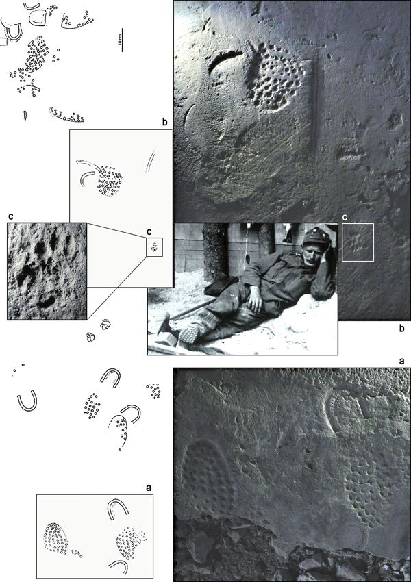
At same time as Pales’s study, Blanc (1960) inferred plantar arc, as highlighted by a strongly convex outline
that some individuals, also including juveniles, travelled on the lateral margin coupled to an appreciable medial
into the cave and reached the innermost room, called embayment. Moreover, this Morphotype shows a strongly
‘Sala dei Misteri’ (Mysteries room). The author especially adducted digit I trace and a consistent separation between
focused on seven human heel traces left close to the main adjacent digit couples II-III and IV-V. Footprints falling
wall of the cave room, and interpreted as the evidence into Morphotype 4 have a total length of 22.80±0,42
of putative prehistoric ritual activity, possibly involving cm and are characterised by parallel digit traces and by
young hunters in initiatory rites (Blanc, 1960). Such a less pronounced medial embayment if compared with
interpretation, according to Blanc (1960), was also the condition observed in Morphotype 3. Morphotype 5
supported by the presence in the room of a stalagmite, includes the largest footprints to date recovered from the
defined by the author as an ‘acephalous sphinx’ or a site that result in general more robust when compared to
‘zoomorphic stalagmite’, preserving a surface of great Morphotypes 3 and 4; footprints have an overall average
interest for intentional finger fluting-drawing, attributable length of 25.73±0.45 cm, with a variably pronounced
to several individuals. plantar embayment and margins that result only slightly
concave. Orientation of digit traces is comparable to the
3.1.3. Ichnology condition in Morphotype 4, while the adducted digit I
Recent surveys in the inner rooms of the cave led to resemble closely the condition described for Morphotype
the recognition of up to 107 human traces represented 3.
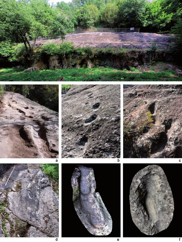
M. Avanzini et al. / Journal of Mediterranean Earth Sciences 12 (2020), xx-xx                          37

Fig. 4 - Selected traces form the Bàsura Cave (Savona). C33) Human footprint referred to the Morphotype 3 (‘lower corridor’); SM15)
human footprint referred to the Morphotype 3 (‘Sala dei Misteri’); CA8) human footprint referred to the Morphotype 3 (‘upper corridor’);
C72) hand print (‘lower corridor’); SM44) finger traces (‘Sala dei Misteri’); SM55) finger flutings on the clay floor (‘Sala dei Misteri’). .
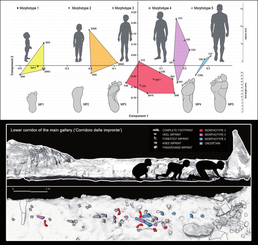
38                             M. Avanzini et al. / Journal of Mediterranean Earth Sciences 12 (2020), xx-xx

   Some footprints referred to Morphotypes 3, 4 and                     an adult individual; by contrast, smaller traces on the
5 are associated in the main gallery to sub-circular                    base of the concretion can more likely be ascribed to a
traces, interpreted as knee imprints, also associated in                young individual, but such evidence is currently under
some cases with fore foot traces (Fig. 5). On the same                  study. More interesting evidence from the inner Sala dei
trampled surface at least six isolated handprints, variably             Misteri are pits and holes excavated on the clay substrate,
preserved as didactyl, tridactyl and pentadactyl prints                 and at the moment preliminary interpreted as deliberate
were recognized. Such footprints have been interpreted                  digging performed with the goal, probably connected to
as traces produced unintentionally by the trackmakers                   clay collecting, to make the finger fluting traces on the
during both stance and progression phases while                         above reported stalagmite concretion.
exploring the lower corridor (Romano et al., 2019).                        The integration of different methodologies favoured
The heel traces already reported and discussed by Blanc                 the reconstruction of the complex exploration in the
(1960) were also considered. Their overall mean width is                Bàsura Cave around 14 ky cal BP (Romano et al., 2019).
about 5.67±0.12 cm, a size comparable to the condition                  The authors inferred that 159 m after having entered the
described for Morphotype 2 (Citton et al., 2017).                       cave and a climb of 12 m, the group reached the lower
   Stature, weight and ontogenetic stage of the putative                corridor (“Corridoio delle Impronte”), which preserves
trackmakers have been reconstructed for each                            the large number of analysed footprints. The group
morphotype (see Citton et al., 2017; Romano et al., 2019)               walked essentially in a single line with the adult ahead
on the base of eight terminal Upper Palaeolithic adult                  followed by younger individuals in the trail; they most
individuals from the Italian Peninsula (Corrain, 1977;                  probably kept themselves close to the cave walls, acting
Paoli et al., 1980; Formicola et al., 1990; Mallegni and                a cautious attitude as when exploring dark and unknown
Fabbri, 1995; Mallegni et al., 2000). The obtained foot                 environments. After about 10 m in the corridor the roof of
length/stature ratios are 0.154, a value fully compatible               the cave drops below 80 cm, so the members of the group
with those proposed by Topinard (1878) and Robbins                      were forced to get down on all limbs and to crawl, leaving
(1985) for modern humans living in between the XIX                      the traces of both knees and hands on the soft substrate.
and XX centuries. Ages and stature reconstructions are                  The adult individual leading the group stopped about after
as follows: a child three-year-old and about 88 cm tall                 few meters, likely in deciding the subsequent sequence
corresponding to Morphotype 1; a child about 110 cm                     of movement and left two parallel calcigrade footprints,
tall around six years old, corresponding to Morphotype                  then proceeding across the section where the roof is at
2; a pre-adolescent about 135 cm tall, probably between                 his lowest point, also followed by the rest of the group.
eight and eleven years old corresponding to Morphotype                  The group descended along a steep surface for about ten
3; a sub-adult to adult about 148 cm tall corresponding to              meters, and traversed a small pond were they left very
Morphotype 4; and a 167 cm tall adult corresponding to                  deep impressions (still under study), and climbed again
Morphotype 5. Stature estimates for the latter have also                up a 10 m slope to finally arrive to the innermost “Sala dei
been corrected and confirmed by the inferred length of                  Misteri”, where they stopped for a short time. Once in this
the tibia derived from the study of the crouching trackway              room, the adolescents and children collected clay from the
(Romano et al., 2019). The results obtained for the                     cave floor and smeared it on the stalagmitic concretion
putative adult individuals, namely Morphotypes 4 and 5,                 (‘acephalous sphinx’ or ‘zoomorphic stalagmite’) at
are fully comparable to the stature inferred for European               different levels, according to their height. In the same
Upper Palaeolithic people, considered to average                        period the ten clear heel traces were formed close to the
162.4±4.6 cm for males and 153.9±4.3 cm for females                     wall, interpreted as calcigrade tracks left by individuals
(Villotte et al., 2017). The arch angles indicate a possible            collecting and manipulating clay on the floor, as already
attribution to a male individual for the largest footprints,            observed and inferred for the ‘Salle des Talons’ at Tuc
whereas for Morphotypes 1, 2, 3 and 4, no definitive                    d’Audoubert cave (Pastoors et al., 2015). Considering the
gender attribution is possible, even if Morphotype 4 most               large number of tracks left in this phase, the group had
probably represents a female individual (Fig. 6).                       to stop for several minutes in the inner room, and before
   Along with the footprints, finger flutings are present               they reached the exit following a path in some sections
in several parts of the cave, with the best-preserved ones              different to the one followed on entry. Based on the
from the inner “Sala dei Misteri” (Mysteries Hall). Finger              footprint orientations and cave topography, they chose
flutings preserved on the terminal wall were classified as              to cross, after the pond, the upper corridor instead of
both Rugolean and Mirian, following the classification                  the lower one, maybe considering it as a safer and more
proposed by Sharpe and Van Gelder (2006) (Fig. 4, SM55).                comfortable pathway (Romano et al., 2019).
The great concentration of finger fluting is reported from                 The multidisciplinary study indicated the hunters-
the stalagmite concretion (‘acephalous sphinx’) briefly                 gatherers behaviour should not always be put in relation
mentioned above, with traces essentially referable to the               to subsistence or practical necessity, but also could
Mirian type and left by at least two different trackmakers,             represent non- utilitarian activities, as also confirmed by
who smeared soft clay on the surface of the concretion.                 diverse ethnographic evidence. The study also confirmed
Traces made on the upper and middle portion of the                      that children younger than 3 years old were following the
stalagmite concretion can be referred, based on size, to                rest of the group also in dangerous and social activities
M. Avanzini et al. / Journal of Mediterranean Earth Sciences 12 (2020), xx-xx                         39

Fig. 5 - Selection of semi-plantigrade and knee traces from the ‘lower corridor’ of the ‘Corridoio delle Impronte’ in the Bàsura cave,
indicating crawling locomotion of the producers. Semi-plantigrade and metatarsal traces (C44 - C44b) and knee traces (C41 - C42)
imprinted on a plastic, waterlogged muddy substrate. a) Cast from the 1950s reproducing two knee (C41, C42) and two metatarsal (C44,
C44b) traces; b) Digital Terrain Model obtained from the HDI 3D Scanner; c) topographic profile with contour lines, obtained from
b; d) interpretive draw. In the knee trace C42 are located the impressions of: patella (a), vastus medialis (b), fibular head (c), patellar
ligament (d) and tibial tuberosity (e).
40                             M. Avanzini et al. / Journal of Mediterranean Earth Sciences 12 (2020), xx-xx

Fig. 6 - Principal Component Analysis (PCA) based on the best-preserved footprints from the Bàsura Cave and reconstruction of
crawling locomotion in the “Corridoio delle Impronte”. The five morphotypes to which footprints have been referred are shown.

and thus were in all respects active members of the Upper               Campana” realized that the eruption had begun, they
Palaeolithic populations (Citton et al., 2017; Romano et                went away in mass with their animals walking on wide
al., 2019).                                                             layers of ash created by the surge cloud. Thousands of
                                                                        human and animal footprints were thereby preserved on
3.2. AFRAGOLA, NOLA AND PALMA CAMPANIA                                  a first layer prior to the massive eruption and the collapse
(CAMPANIA REGION, SOUTHERN ITALY)-                                      of the eruptive column with consequent pyroclastic flows.
HOLOCENE                                                                In the first layer, wooden elements and remains of other
   The protohistoric villages of Afragola, Nola and Palma               non-carbonized plants were found. This testifies that
Campania (southern Italy, Campania region) are vivid                    the levels created by the surge-cloud had a relatively low
examples of the culture and everyday life of the oldest                 temperature, so that people who chose to run away did
populations of Campania region (Fig. 1). They were                      not suffer serious harm (Mastrolorenzo et al., 2006).
affected by the volcanic phenomena that preceded and
followed the great eruption of the Summa/Vesuvius                       3.2.1. Geological setting
commonly called “Eruzione delle Pomici di Avellino” or,                   Deposits formed by this violent Plinian eruption have
simply, “di Avellino” (Mastrolorenzo et al., 2006; Di Vito              been dated to 3780 yrs BP by 14C (Mastrolorenzo et al.,
et al., 2009). When the ancient inhabitants of the “Piana               2006; Di Vito et al., 2009) (Fig. 7a). At least two trampled
M. Avanzini et al. / Journal of Mediterranean Earth Sciences 12 (2020), xx-xx 41 layers have been surveyed: the layer already described as the eruption (white/grey pumices, lapillus, ashes) thus created from the ashes of the surge and those created by being preserved from the pyroclastic impetus and from the pyroclastic flows and the following floods and lahars the following hydrogeological events (acid rain, lahar, (Mastrolorenzo et al., 2006). The first footprints during etc.) (Mastrolorenzo et al., 2006). As some flood and the mass exodus were filled by the lightest materials of lahar deposit preserves some fossil footprints, it has been Fig. 7 - The Campanian plain showing Vesuvius, the Afragola Bronze Age village and the distribution of Pomici di Avellino deposits (a). Isopachs in cm, Eruptive Unit 2: white; Eruptive Unit 3: black, Eruptive Unit 5: dark grey (after Di Vito et al., 2009); b) Aerial view of the footprints made during the eruption and traces of three storehouses (after Laforgia et al., 2009); c) Footprints of two fugitives in the surge ash deposit found ≈15 km NNW of Vesuvius: thousands of footprints directed NNW away from the volcano testify to an en masse exodus from the devastated zone (after Mastrolorenzo et al., 2006).
42                             M. Avanzini et al. / Journal of Mediterranean Earth Sciences 12 (2020), xx-xx

inferred that human and animal exodus continued also                    cm. Both footprints show a very raised and well-defined
during ash-fall and after the storms of rain and the floods             plantar arch, which demonstrate that they were left by
(Mastrolorenzo et al., 2006).                                           unshod feet. It is not known whether the footprints on
                                                                        display were the only ones to be found, as no scientific
3.2.2. Ichnology                                                        publication has been dedicated to this ichnological
   The best investigated village, from a paleo-ichnological             discovery (Panarello, 2016b).
point of view, is Afragola (Giampaola et al., 2007).
However, the collected data and the geo/ichnological                    3.4. AOSTA (NORTHERN ITALY)-HOLOCENE
evidence is almost the same as for other surrounding sites                Archeological excavations during June 2014 in an area
for a radius of at least 15 km. In these areas, thousands of            occupied by the former gym of the CONI (National Sport
human and animal footprints have been found on various                  Federation) brought to light a series of attendance plans
depositional levels both inside and outside villages (Fig. 7            related to agricultural activities (Regione Valle d’Aosta,
b,c). The footprints within the boundaries of the ichnosite             2015; Panarello, 2016b; Amirotti et al., 2017) (Fig.1). On
of Afragola are mainly human and are randomly organized                 the last of these levels, a series of footprints of at least two
and concentrated around huts. Overlaps, slips, sudden                   adult and a child are documented, as well as a series of
changes of direction and jumps are common and clearly                   animal footprints (Fig. 8). Stratigraphic analysis placed
visible everywhere. The tracks, which are oriented away                 these traces into the second Iron Age (5th-1st century BC).
from the village for distances of up to 1 km, are oriented              The available data show narrow tracks with aligned step
in various directions (Laforgia et al., 2009). Given the                sequences of apparent barefoot individuals still under
large number of human footprints, palaeo-ichnological                   study.
measurements were carried out on a sample located in
a small area outside the village. Referring to the human                3.5. FIRST WORLD WAR SOLDIER TRACKS FROM
remains found in the nearby village of San Paolo Belsito,               THE VALMORBIAWERK AND FROM OTHER
the sex of which is also known, sample imprints were                    MILITARY STRUCTURES IN TRENTINO- ALTO
attributed to 13 individuals whose stature supposedly                   ADIGE REGION (TRENTO, NORTHERN ITALY)-
did not exceed 1.40 m. These individuals have been                      HOLOCENE
considered as non-adults or children of unidentifiable sex.                Avanzini et al. (2011) and Avanzini (2012) described
Other footprints have been attributed to 57 individuals                 several boot tracks detected on the floor of tunnels and
whose estimated stature ranged from 1.40-1.70 m. The                    trenches of the First World War in the Trentino-Alto
footprints of 9 other individuals suggest estimated stature             Adige Region (Northern Italy). These traces represented
exceeding 1.70 m so that they were attributed to adults of              the first report of footprints left by First World War
unknown sex. The speeds calculated from footprints vary                 soldier tracks, and were used to throw light on everyday
from 2.5 to 5.4 km/h in 89.6% of the sample (Laforgia et                life activities carried out in the underground bunker
al., 2009).                                                             systems.
   Animal footprints are associated with human ones.
They were left by cattles (Bos taurus), sheep and goats,                3.5.1. The Valmorbiawerk (Vallarsa, Trento)
Equidae (both donkeys and horses), cats and dogs. Tracks                   The Valmorbiawerk, known as Forte Pozzacchio in
of deers, porcupines, squirrels, and other rodents have                 Italian documents, is placed on the right side of the
also been identified (Laforgia et al., 2009).                           Vallarsa Valley, at about 8 km from Rovereto in the
                                                                        Trentino-Alto Adige region, at an altitude of 882 m a.s.l.
3.3. POMPEI AREA (CAMPANIA REGION,                                      (Fig. 1). The fort pertains to a system of fortifications
SOUTHERN ITALY)-HOLOCENE                                                planned at the beginning of the twentieth century by the
  In Moregine, a small village located near the Sarno                   Austro-Hungarian Empire, scared that Italy would try to
river, about 600 m south of the walls of the ancient city of            obtain further territory in the Veneto Region (Fontana,
Pompeii, remains of a majestic Roman villa were found in                2004; Righi and Leonardi, 2006; Avanzini et al., 2011).
1959 (Fig. 1). The villa was destroyed by the same eruption             However, by the beginning of First World War in July
that buried Pompeii and therefore can be dated back to                  1914 the structure was incomplete and when Italy enter
79 AD. Its magnificently preserved frescoes, with many                  the war on January 30th, 1915 all the works in the fort
of the unearthed furnishings, are shown in a permanent                  were abandoned. The 80th regiment of the Italian infantry
exhibition created in the “Great Gym” of ancient Pompeii.               occupied the fort on June 13, 1915, but the structure was
Here, some casts of three footprints of human bare feet                 recaptured by the Austro-Hungarian troops in May 1916
are exposed. The arrangement of the footprints suggests                 by the Strafexpedition, and controlled until the end of
they could not belong to the same trackmaker. The casts                 First World War (see Avanzini et al., 2011).
of the footprints were made with plaster castings, so that
the data that were possible to survey must be considered                3.5.2. Ichnology
mostly approximate. The dimensions of the two entire                      The boot tracks are preserved in one internal cave of the
footprints are as follows: right foot - length 24.5 cm,                 fort, likely dedicated to storage room, and are impressed
width 11.6 cm, left foot - length 24.6 cm, width 10.5                   on a 30 cm wide concrete curb which constitutes the
M. Avanzini et al. / Journal of Mediterranean Earth Sciences 12 (2020), xx-xx 43 Fig. 8 - Archaeological excavation of the new hospital in Aosta. Human and animal footprints on a palaeosurface of the second Iron Age (after Amirotti et al., 2017). perimeter of the room and raised 40 cm from the floor. On boots of soldiers in First World War in both Austro- the top of the curb is a 2-3 mm thin layer of pure cement Hungarian or Italian mountain troops. However, the on which the boot tracks were impressed and preserved peculiar pattern of hobnails disposition on the sole (Avanzini et al., 2011). The authors recognized a series of depends strictly on the nationality and branch of the four walking patterns with a total length of 5.60 m, with armed services. Avanzini et al. (2011) have been able to an oblique pace length of 78-80 cm, a stride equals to ascribe the recognizable pattern to mountain footwear 154-160 cm and a pace angulation ranging between 175° used by the Austro-Hungarian army (Bergschuhe) like and 180°; the foot angle is outwardly rotated between 15° other footprints recovered in several First World War to 20°. General morphology, and in particular the hobnail mountain trenches (Luserna-Oberwiesen, Monte Nagia- layout, led the authors to refer all the tracks to the left Grom, Pasubio) (Avanzini, 2012) (Fig. 9g). Based on and right boots of a same individual (Fig. 9 a-d). In all the inferred foot length of about 27 and 27.5 cm, and the studied traces, the heel region results the deepest using the ratio provided by Topinard for foot length/ impressed, due to the presence of a reinforcement made height of 15% (Helmuth, 1974) and the values of 13.47% by rectangular and square-shaped hobnails. Comparing and 15.98% proposed by several authors (Burke, 2002; all the analysed footprints, Avanzini et al. (2011) were Fessler et al., 2005; Brenda and Rohreni, 2006; Kumar et able to reconstruct the whole hobnail pattern of both al., 2007), Avanzini et al. (2011) reconstructed a possible left and right boots (Fig. 9e). In particular, the rim of the height for the trackmaker of about 1.77-1.80 m; this is sole and heel were characterised by a close arrangement also in accordance with the value calculated starting by of nails with a rectangular base; around the tip the nails the length of the reconstructed shoe (shoe length/stature were uniformly and closely arranged in a group of 15, and ratio of 16.63%; see Giles and Vallandingham, 1991; disposed in pairs along the sides. The sole was differently Ozden et al., 2005; Brenda and Rohreni, 2006). characterised by semicircles of quadrangular hobnails, Based on general structure and preferential wear and another series that were aligned according to the foot evidence from the traces, Avanzini et al. (2011) main axis. reconstructed a quite normal locomotion pattern, As stressed by Avanzini et al. (2011), the use of characterised by a slight lateral foot functional prevalence footwear reinforced with hobnails was common in the (Fig. 9f); the evidence allows reconstruction of a possible Alps until the 1950s and such features characterize the trackmaker as a slender tall soldier showing a slightly
44                                M. Avanzini et al. / Journal of Mediterranean Earth Sciences 12 (2020), xx-xx

Fig. 9 - Valmorbiawerk fort site (Trentino-Alto Adige). a) Single well-preserved left boot tracks; b) partial right footprints; c) footprint
heels with sliding track; d) superimposed trackways; e) the two reconstructed soles as seen from below; f) traces of use recognizable in
the right foot ; g) Austro-Hungarian troops’ mountain footwear sole (Bergschuhe).

varus knee, with a weight around 70-80 kg based on
the formula proposed by Robbins (1985, 1986), and                          3.5.3. The military kitchens of Monte Celva, Trento
proceeding at a speed around between 1.67 and 1.80 m/s                       The fortified complex of Monte Celva, located
based on Alexander (1984). The individual very likely left                 immediately east of the city of Trento, was part of the
the footprints in the fresh concrete between spring 1914                   defensive belt of the Trentino capital developed by the
(beginning of the work in the secondary tunnels) and                       Austro-Hungarian Military Engineer in the second half
May 1915 (end of the works; see Fontana, 2005).                            of the 1800s (Fig. 1). From autumn 1914 until spring 1916
M. Avanzini et al. / Journal of Mediterranean Earth Sciences 12 (2020), xx-xx                            45

the city was surrounded by a formidable entrenched field                  occupied by the Austro-Hungarian army, but the traces
network and equipped with walkways, concrete casemates                    are very different from those of the mountain footwear
and batteries dug into the rock. Monte Celva (998 m a.s.l.)               “Bergschuhe”. Austrian infantries were equipped with
was completely fortified with an articulated system of                    two main models of footwear. The first consisted of
entrenches and tunnels that connected artillery casemates                 boots with pointed soles. The nails on the sole had the
and steel dome pieces to which an efficient logistic system               same arrangement as the Bergschuhe but the pointed
consisting of deposits, dormitories and warehouses, was                   nails on the margin were missing, replaced by a row of
associated. The work, which began at the dawn of the                      round nails and the heel was reinforced by a horseshoe
conflict and continued throughout the first year of the                   plate. The second model, less frequent, was a boot with
war, involved hundreds of local workers. In the autumn                    a more square sole and a squat point. In this case, the
of 1915 there were 1538 workers, including 714 prisoners.                 round-headed nails were arranged in rows transversal to
The batteries had a staff of eight officers and 243 soldiers to           the sole and did not reach the edge: a metal horseshoe
which could be added another 16 officers and 900 soldiers                 reinforcement completed the heel. It is therefore evident
housed in the warehouses of Pramarquart not far away,                     that our traces are to be referred to infantry troops who
and almost 1500 men of reserve troops in case of need.                    were employed also in the defence of mountain posts.
It is clear that with a number of men of this magnitude                   Animal traces belong to a small carnivore. Wild animals
the field kitchens in which meals for workers and soldiers                such as foxes and martens are excluded in shape and size.
were prepared were in full swing while the preparatory                    Even small domestic dogs are excluded due to morphology
work was still going on around them.                                      and the absence of nails. The closest similarities are with
                                                                          traces left by a medium-sized domestic feline.
3.5.4. Ichnology                                                            The scene is lively: while the floor has just been finished
   Several human and animal footprints are preserved on                   by the workers, a soldier is busy between the kitchen
the concrete floor of one of the Monte Celva kitchens.                    and the warehouse, one of his fellow soldiers (part of a
Three cave entrances open onto an entrenched courtyard                    different contingent) looks out into the corridor, but
protected downstream by a concrete wall. Of the three                     realizing that the concrete is still fresh stops on the point
galleries, one was the kitchen, with the others intended                  of the boots and takes a step back; heedless of the two
for housing and storage. A corridor allowed the internal                  soldiers, a cat escapes from the kitchen taking refuge in
connection to the warehouse caves: dozens of different                    the deepest part of the galleries.
sizes and types of footprints are imprinted on its floor.
The most abundant footprints correspond to shoes with                     4. CONCLUDING REMARKS
soles covered by regular rows of nails with a rounded
head and the heel reinforced by a sturdy metal plate (Fig.                   For just over thirty years, palaeoichnology has begun to
10a). These are elongated soles ending with a relatively                  recognize in human fossil footprints important support
pointed profile. The same type of footprints is preserved                 for understanding our history. The documentation of such
in the galleries of the fort of the Sommo alto (Folgaria)                 finds in Italy is still sporadic and new finds are still scarce.
(Avanzini, 2012). They are 28 cm long and correspond                      Despite this, some of the sites recently studied confirm
to the right and left foot of the same individual who                     the great interpretative potential of the discipline. One
moved irregularly from the kitchen to the warehouse.                      of the most interesting aspects of the Roccamonfina site
Using the methods already described above, it appears to                  is, for example, the dynamic movement frozen over the
have been about 168 cm tall and weighing just over 65 kg.                 time. The same can be said of the traces preserved in the
More squat shoes, with a quadrangular tip and with                        internal corridors of the Grotta della Bàsura which, for the
rows of large and small nails alternating and aligned in                  first time, clearly describe human exploration behaviour
transverse rows with respect to the sole, are imprinted on                in complex environments. Even the most recent footsteps,
the lateral edge of the connection tunnel (Fig. 10b). They                linked to the chronology of the 20th century, are proving
are two right footprints both oriented from the warehouse                 to be instruments with high educational potential in
towards the kitchen. The heel is raised and the weight of                 support of the narration of well-known historical events.
the author’s body (about which, however, it is not possible
to say much) is unloaded all over the front of the foot.                     ACKNOWLEDGEMENTS - We thank Martin G. Lockley and
Among them, preserved in several points on the floor, the                 an anonymous referee for reviewing and critical comments. Part of
traces of a small mammal are recognizable. Four elliptical                the research was funded by the Soprintendenza Archeologia Belle
digit traces are placed in front of a heart-shaped plantar                Arti e Paesaggio per la Città Metropolitana di Genova e le province
pad. More rounded outline footprints are associated with                  di Imperia, La Spezia e Savona, Genoa, Italy, the Municipality of
more elongated ones suggesting the presence of hand-foot                  Toirano and by the National Geographic Early Career Grant to
pairs of the same animal. The dimensions vary between 3                   MR. (EC-53477R-18) “A multidisciplinary approach to a unique
and 4 centimetres in length with a length / width ratio of                human ichnological record from the Grotta della Bàsura (Toirano,
approximately 1. There are no traces of nails. The length                 Savona Italy)”.
of the author’s body was to be about 40 cm (Fig. 10c).
What emerges this time? The fortifications were
46 M. Avanzini et al. / Journal of Mediterranean Earth Sciences 12 (2020), xx-xx Fig. 10 - Monte Celva site (Trentino-Alto Adige). a) Shoes prints with regular rows of nails and reinforced by a sturdy metal plate; b) squat prints with a quadrangular tip and with rows of large and small nails; c) cat footprints; d) Austro-Hungarian infantry troops employed in the fortress.
M. Avanzini et al. / Journal of Mediterranean Earth Sciences 12 (2020), xx-xx                          47

REFERENCES                                                                        europei emergono dal vulcano di Roccamonfina (Caserta).
                                                                                  La Ricerca 25, 16.
Acocella, A., 2013. Stile laterizio II. I laterizi cotti fra Cisalpina e      Avanzini M., Romano M., Citton P., Salvador I., Arobba D.,
    Roma, Media MD, 2013, pp. 76.                                                 Caramiello R., Firpo M., Rellini I., Negrino F., Clementi L.,
Alexander R.Mc.N., 1984. Stride length and speed for adults,                      Zunino M., Giannotti S., Starnini E., Conventi M., 2018.
    children, and fossil hominids. American Journal of Physical                   Icno-archeology of a human Palaeolithic ecosystem: the
    Anthropology 63, 23-27.                                                       human and animal footprints in the Grotta della Bàsura
Almécija S., Smaers J.B., Jungers W.L., 2015. The evolution of                    (Toirano, Northern Italy). Alpine and Mediterranean
    human and ape hand proportions. Nature communications                         Quaternary 31, 39-42.
    6, 7717.                                                                  Ballini A., Barberi F., Laurenzi M.A., Mezzetti F., Oddone M.,
Altamura F., Bennett M.R., D’Août K., Gaudzinski-Windheuser                       Villa I.M., 1990. Chrono-Stratigraphy of Roccamonfina
    S., Melis R.T., Reynolds S.C., Mussi M., 2018. Archaeology                    volcanic complex. In: Genesi e differenziazione del
    and ichnology at Gombore II-2, Melka Kunture,Ethiopia:                        magmatismo potassico del bordo tirrenico: convegno
    everyday life of a mixedage hominin group 700,000 years                       autunnale: Ischia, 15-18 ottobre 1990. Società Italiana di
    ago. Nature: Scientific Reports 8, 2815.                                      Mineralogia e Petrologia, Abstract book, 18-19.
Armirotti A., De Davide C., Wicks D., 2017. Scavi per                         Ballini A., Barberi F., Laurenzi M.A., Mezzetti F., Villa
    l’ampliamento dell’Ospedale regionale Umberto Parini                          I.M., 1989a. Nuovi dati sulla stratigrafia del vulcano di
    di Aosta: sintesi dei principali risultati. Bollettino della                  Roccamonfina. Bollettino G.N.V. 2, 533-556.
    Soprintendenza per i beni e le attività culturali, Regione                Ballini A., Frullani A., Mezzetti F., 1989b. La formazione
    Valle d’Aosta 14, 14-31.                                                      piroclastica del Tufo Trachitico Bianco («White Trachytic
Appleton J.D., 1972. Petrogenesis of potassium rich lavas from                    Tuff»-WTT Auctorum) del vulcano di Roccamonfina.
    the Roccamonfina Volcano, Roman region, Italy. Journal of                     Bollettino Gruppo Nazionale Vulcanologia 2, 557-574.
    Petrology 13, 425-456.                                                    Bennett M.R., Harris J.W.K., Richmond B.G., Braun D.R.,
Arsuaga J.L., Carretero J.M., Lorenzo C., Gómez-Olivencia                         Mbua E., Kiura P., Olago D., Kibunjia M., Omuombo C.,
    A., Pablos A., Rodríguez L., Martínez I., 2015. Postcranial                   Behrensmeyer A.K., Huddart D., Gonzalez S., 2009. Early
    morphology of the middle Pleistocene humans from Sima                         hominin foot morphology based on 1,5-million-year-old
    de los Huesos, Spain. Proceedings of the National Academy                     footprints from Ileret, Kenya. Science 323, 1197-1201.
    of Sciences 112, 11524-11529.                                             Blanc A.C., 1960. Le palline d’argilla della Grotta della Bàsura.
Arsuaga J.L., Martínez I., Arnold L.J., Aranburu A., Gracia-                      Rivista di Studi Liguri 26, 9-25.
    Téllez A., Sharp W.D., Poza-Rey E., 2014. Neandertal roots:               Blanc A.C., Pales L., Lamboglia N., 1960. Le Vestigia Umane
    Cranial and chronological evidence from Sima de los                           nella Grotta della Bàsura a Toirano. Istituto Internazionale
    Huesos. Science 344, 1358-1363.                                               di Studi Liguri, Bordighera, Italia.
Ascenzi A., Biddittu I., Cassoli P.F., Segre A.G., Segre-Naldini              Brenda M.A., Rohreni M.A., 2006. Estimation of Stature from
    E., 1996. A calvarium of late Homo erectus from Ceprano,                      Foot and Shoe Length: Applications in Forensic Science.
    Italy. Journal of Human Evolution 31, 409-423.                                Internal report, Nebraska Wesleyan University, Department
Ascenzi A., Mallegni F., Manzi G., Segre A.G., Segre-Naldini                      of Forensic Science. Available from: www.neiai.org/index.
    E., 2000. A reappraisal of Ceprano calvaria affinities with                   php.
    Homo erectus, after the new reconstruction. Journal of                    Buryanov A., Kotiuk V., 2010. Proportions of Hand Segments.
    Human Evolution 39, 443-450.                                                  International Journal of Morphology 28, 755-758.
Ashton N., Lewis S.G., De Groote I., Duffy S.M., Bates M.,                    Bruzzone D., Bussallino M., Castello G., Maggiolo S., Rossi D.,
    Bates R., Hoare P., Lewis M., Parfitt S.A., Peglar S., Williams               2006. Measurement of the concentration of radon gas in the
    C., Stringer, C., 2014. Hominin foot-prints from Early                        Toirano’s caves (Liguria). Annali di Chimica 96, 515-524.
    Pleistocene deposits at Happisburgh, UK. Plos One 9,                      Burke T.R., 2002. Tell tale footprints: Determination of stature
    e88329.                                                                       from foot length in forensic cases. California State Science
Avanzini M., 2003. Il primo alpinista: 350.000 anni fa sui fianchi                Fair, Project Number J1003 (Abstract). Available from:
    di un vulcano. Natura Alpina 53, 1-5.                                         http://www.usc.edu/CSSF/History/2002/Projects/J1003.pdf.
Avanzini M., 2011. A spasso nel tempo. Darwin 43, maggio/                     Carretero J.M., Rodríguez L., García-González R., Arsuaga
    giugno 2011, Editoriale Darwin S.r.l, Roma, 16-21.                            J.L., Gómez-Olivencia A., Lorenzo C., Bonmatí A., Gracia
Avanzini M., 2012. Orme dal passato: storie di uomini in guerra.                  A., Martínez I., Quam R., 2012. Stature estimation from
    Archivio Trentino 1, 107-125.                                                 complete long bones in the Middle Pleistocene humans
Avanzini M., Bernardi M., Petti F.M., 2011. Soldier tracks in a                   from the Sima de los Huesos, Sierra de Atapuerca (Spain).
    First World War Fort (Valmorbiawerk, Trento, Italy). Ichnos                   Journal of Human Evolution 62, 242-255.
    18, 72-78.                                                                Charteris J., Wall J.C., Nottrodt J.W., 1982. Pliocene hominid
Avanzini M., Mietto P., De Angelis M., Panarello A., Rolandi                      gait: new interpretations based on available footprint data
    G., 2008. The devil’s trails: Middle Pleistocene human                        from Laetoli. American Journal of Physical Anthropology
    footprints preserved in a volcanoclastic deposit of southern                  58, 13-144.
    Italy. Ichnos 15, 179-189.                                                Chiappella V.G., 1952. Orsi e uomini preistorici nella Grotta
Avanzini M., Mietto P., Rolandi G., 2003. Le orme dei più antichi                 della Strega. Rivista del Comune di Genova 29, 22-29.
You can also read