IAP What's In It For Me? - THE CITY OF NEWCASTLE - Transport Certification Australia
←
→
Page content transcription
If your browser does not render page correctly, please read the page content below
IAP What's In It For Me?

THE CITY OF NEWCASTLE
Opening up access for a new generation of higher
productivity vehicles is helping to deliver
productivity, safety and environmental benefits
for the community of Newcastle and the Hunter
Region.

OVERVIEW OF NEWCASTLE AND THE
HUNTER REGION
Transport and logistics has been at the forefront of
Newcastle and the Hunter Region’s economy since coal was
discovered in 1797. The ability to obtain secure access for
ships into the Hunter River led to the development of             Newcastle’s manufacturing sector has long been associated
Australia’s first commercial port at Newcastle. Coal has now      with heavy industry, based on the steelworks which closed in
underpinned the development of Newcastle and the Hunter           1999. This was symptomatic of a significant economic
Region for over 200 years. Today, Newcastle is the world’s        restructuring in the manufacturing sector since the 1970’s
largest port for the movement of coal, which is taken to port,    towards high technology and higher valued production in
for export by train. The port remains a major strategic asset     areas such as information technology, aerospace, transport
to the regional economy.                                          engineering, metals processing and fabricated metal
                                                                  production.
THE CITY OF NEWCASTLE’S SOCIAL
                                                                  Major areas zoned for industrial land within the City of
AND ECONOMIC BASE                                                 Newcastle are located in the suburbs of Mayfield North,
Newcastle’s boundaries extend south just beyond                   Mayfield West, Carrington, Kooragang Island, Sandgate,
Merewether and Kotara, south west to Elermore Vale and            Hexham, Beresfield and Broadmeadow.
Minmi, north west to Beresfield, to the northern boundaries of    The ownership and use of industrial land within the Council’s
Kooragang Island and northwards up the coast just beyond          boundaries is complex. Much of the land that is currently
Stockton. While the population of the City of Newcastle is        available for development is brownfield land that tends to be
slightly over 140,000, it services a population of over 500,000   less attractive to developers and other investors when
including neighbouring councils of Lake Macquarie,                compared to greenfield development opportunities. The
Cessnock, Maitland and Port Stephens. Newcastle is also           suburb of Beresfield offers developers and industry the
the service centre for communities beyond these lower             opportunity to invest in a greenfield location.
Hunter Region councils, especially those communities based
in the Upper Hunter, parts of the Central Coast as well as the    Newcastle Port Corporation owns land in the port precinct,
Mid-North Coast.                                                  which is subject to development, driven primarily by the
                                                                  expansion of coal exports. Another challenge for the Council
This means Newcastle and the surrounding Regions have a           is to ensure support industries, including transport and
diverse economic base which services significant sectors of       warehousing, have access to land near the Port to enable
the economy such as manufacturing, mining, agriculture,           those industries to provide efficient service to sectors which
construction, health, education and community services.           are reliant on the Port.

                                                                  NEWCASTLE’S ROLE AS A
                                                                  TRANSPORT HUB
                                                                  As the second largest city in NSW and the seventh largest
                                                                  city in Australia by population, Newcastle continues to be a
                                                                  major transport hub for all freight modes. Its diverse
                                                                  manufacturing base and strong construction and retail
                                                                  sectors mean there is a strong demand for freight.
                                                                  .

www.tca.gov.au
                                                                                                                             1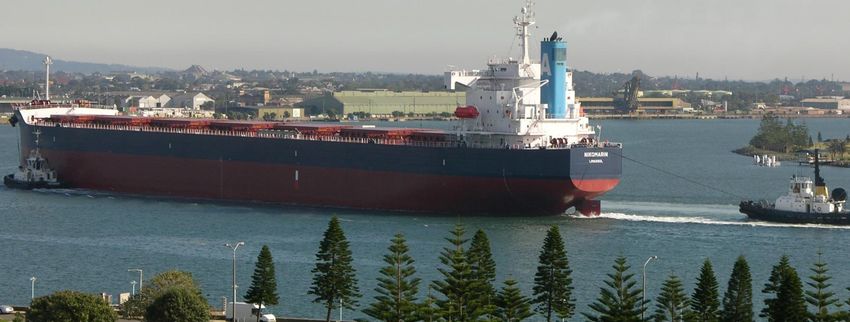
IAP What's In It For Me?
The junction of the F3 Freeway linking Sydney with the Beresfield to Kurri Kurri via the New England Highway
Pacific Highway and the New England Highway is at Tarro, and Cessnock Road
west of the greater urban area of Newcastle. Both routes Beresfield to Port Stephens via the Pacific Highway,
provide access to Brisbane. Newcastle is also the hub for an Richardson Road and Nelson Bay Road.
extensive network of State and Regional roads.
There is also an extensive HML short combination B-Double
Newcastle has Higher Mass Limits (HML) access to: network where access for B-Doubles up to 26 metres is not
Sydney and the Central Coast via the F3 Freeway feasible due to route alignment issues.
Melbourne and the Victorian HML network via the F3 Aside from the Maitland Road rail bridge at Tighes Hill, which
Freeway, Pennant Hills Road, Sydney’s motorway is owned by State Rail, other bridges which are not built to a
network and the Hume Highway standard to allow HML access on the State and Regional
Wollongong via the F3 Freeway, Pennant Hills Road, Road networks, include:
Sydney’s motorway network, Hume Highway, Picton
New England Highway at Aberdeen
Road and the Princes Highway
Pacific Highway at Bulahdelah
Dubbo, HML networks in western NSW, South
Australia, Western Australia, western Queensland Bridge over the railway line on University Drive at
and the Northern Territory via the New England and Waratah West
Golden Highways. Bridge over the railway line on Lake Road at Boolaroo
There is an extensive HML network within the City of Pacific Highway at the entrance to Lake Macquarie
Newcastle. Access for HML B-Doubles is possible on the Hunter River at Raymond Terrace
following routes: Bridge over the railway line on Cessnock Road
The Port of Newcastle from Port Access Road at between Kurri Kurri and Weston
Carrington to: Bridge on Anderson Drive, Beresfield west of Byron
○ Industrial areas in Mayfield, Mayfield West, Street.
Hexham, Sandgate, Beresfield, Maitland,
These bridges inhibit HML access from Newcastle to
Singleton, Muswellbrook and Aberdeen via
Brisbane, Cessnock, western and southern areas of Lake
Darling Street, Parker Street, Elizabeth Street, Macquarie and coastal communities north of Wyong.
Industrial Drive, the Pacific Highway (west of However, bridge construction at Aberdeen, once completed,
Industrial Drive) and the New England Highway can be expected to allow HML access to Brisbane.
○ Tomago, Raymond Terrace and Bulahdelah via Completion of the Hunter Expressway can be expected to
Hexham and the Pacific Highway improve HML access to the Cessnock Region.
○ The F3 Freeway and the Western Suburbs via
Hannell Street, Parry Street, Donald Street, IMPORTANCE OF TRANSPORT TO THE
Griffiths Road, Newcastle Road, Thomas Street
and Newcastle Link Road
NEWCASTLE ECONOMY AND
○ Cardiff and Warners Bay via Hannell Street to
EMPLOYMENT
Thomas Street as above, and then Lake Road, According to the City of Newcastle Infrastructure
Main Road and Macquarie Road as far as the Management Services Manager, John Johnston, ‘Efficient
junction with Medcalf Road and Hillsborough transport links continue to underpin economic and
Road employment growth in Newcastle.’
○ Charlestown via Hannell Street, Stewart Avenue,
City Road and the Pacific Highway
○ Kooragang Island, Newcastle Airport
(Williamtown) and Port Stephens via Industrial
Drive, Tourle Street, South Arm Road, Teal
Street, Fullerton Road and Nelson Bay Road
○ Kurri Kurri via Hexham, the New England
Highway and John Renshaw Drive.
Maitland Road from Warabrook to Frith Street from:
○ Warners Bay to Sandgate via Macquarie Road,
Lake Road, Thomas Street, Newcastle Road and
the Main Road Bypass
www.tca.gov.au
2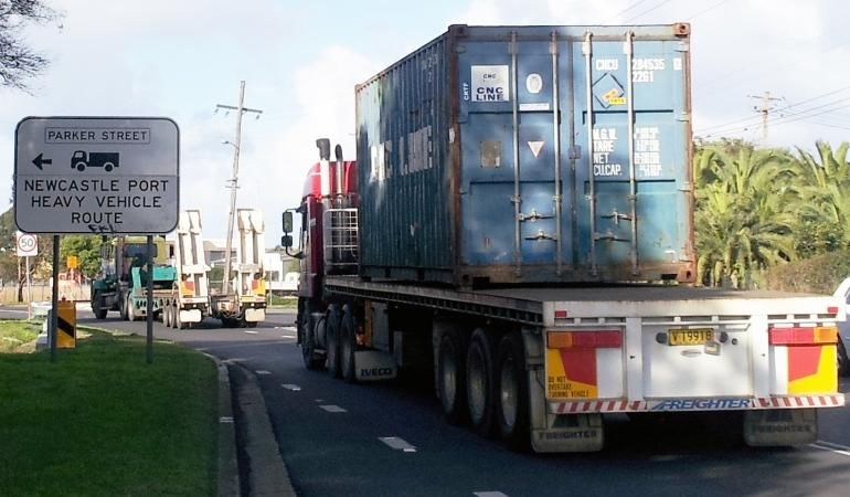
IAP What's In It For Me?
‘Newcastle enjoys a generally good State and Regional road
network. Having HML access to major destinations such as
THE LOCAL NETWORK
Sydney (including Port Botany) and Melbourne, are also The City of Newcastle has 38.5 km of State and 43.96 km of
important given the freight volumes moving to and from Regional roads as well as 743 km of local roads.
these markets.’
There are 260 bridges and culverts including small
‘However it is important that the Aberdeen Bridge upgrade is stormwater culvert crossings on local roads.
complete so HML access is available to Brisbane and north
western NSW. Newcastle businesses would also benefit Route functionality and the establishment and maintenance
from improved HML access to the Hunter Valley following the of a hierarchical approach to each local road, has been
completion of the Hunter Expressway between Seahampton especially important to the Council for many years because
and Branxton,’ Mr Johnston said. of the importance of road transport to the heavy vehicle
industry, coal mining and supporting industries.
WORKING WITH INDUSTRY
WORKING WITH TRANSPORT
Mr Johnston says that the City of Newcastle will ensure
every reasonable effort is made to support more efficient
OPERATORS
access for transport operators. Mr Johnston said, ‘16 transport operators have applied for
access within the City of Newcastle to operate under the
‘Council officers work closely with transport operators and
where necessary their customers, to assess requests for Intelligent Access Program (IAP).’
more efficient access onto the Council’s network.’ ‘Council officers assessed applications to access the local
road network and developed an understanding of the IAP.
‘While we do have to balance the needs of industry with the
needs of the local community, these interests are often This was critical to enabling them to make an informed
aligned because more efficient freight operations are often decision regarding each access request.’
also safer and more environmentally friendly’, Mr Johnston ‘We are very comfortable with the level of compliance
said. assurance provided by the IAP. In short the Council’s view is
that the transport operators enrolled in the IAP will comply
‘Other key stakeholders are the Newcastle Port Corporation
and intermodal rail operators located on Kooragang Island with conditions to access approved routes.’
and at Beresfield which have a very important strategic role ‘Council has approved requests for HML access on a total of
in working with the trucking industry to deliver safe and nine routes on local roads as well as Performance Based
efficient logistics solutions.’ Standards (PBS) vehicle access on three routes.’
‘The port of Newcastle and these intermodal terminals are ‘Access along these routes was only made possible thanks
accessible to HML B-Doubles’, Mr Johnston said. to the assurance provided to the City of Newcastle through
the IAP,’ Mr Johnston said.
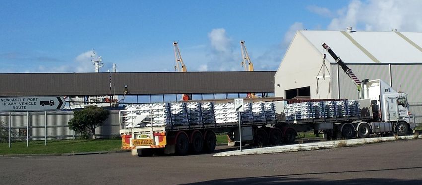
Heavy vehicles travelling at HML can carry up to 68 tonnes,
an increased payload of approximately 10% to 13%.
www.tca.gov.au
3
IAP What's In It For Me?
PRODUCTIVITY, EFFICIENCY AND
ENVIRONMENTAL BENEFITS AT A GLANCE
According to Mr Johnston, ‘Significant reductions in fuel Efficient transport links continue to underpin
consumption and environmental emissions can be directly economic and employment growth in
attributed to decisions to approve access for HML vehicles Newcastle.
and PBS level 2 vehicles. Higher payloads generated on
these vehicles results in fewer emissions per tonne kilometre 16 transport operators have applied for access
and a reduction in truck trips.’ within the City of Newcastle to operate under
the IAP.
‘These environmental benefits are only possible because the
IAP provides the City of Newcastle with a sufficient level of Newcastle Council has approved requests for
compliance assurance, consistent with its responsibilities as HML access on a total of nine routes as well as
a road asset manager,’ Mr Johnston said. PBS vehicle access on three routes.
FURTHER INFORMATION Reductions in fuel consumption and
environmental emissions can be attributed to
For further information, visit the TCA website at HML and PBS level 2 vehicles.
www.tca.gov.au
Access was only made possible thanks to the
assurance provided to Newcastle Council
through the IAP.
www.tca.gov.au
4
IAP What's In It For Me?

APPROVED CITY OF NEWCASTLE ROADS FOR HML VEHICLES
Suburb                      Road                               Description

Carrington                  Elizabeth St and                   From Industrial Drive, Elizabeth Street, Darling Street, Robertson Street to
                            Darling Street                     east end of the road
                            (MR7772)

Hexham                      Shamrock Street                    From Pacific Highway to end of Shamrock Street

Hexham                      Sparke Street                      From Pacific Highway to end of Sparke Street

Maryland                    Creek Road                         From Minmi Road to end of Creek Road

Mayfield North              Ingall Street                      From Industrial Drive to end (north)

Mayfield North              Woodstock Street                   North of Industrial Drive

Wickham                     Mary Street                        From Hannell Street to end of Mary Street

Wallsend                    Longworth Avenue                   From Newcastle Road to Longworth Avenue

Broadmeadow                 Chatham Road                       Griffiths Rd/Donald St to entrance to Shell Petrol Station
                                                               (5 -7 Chatham Road)

APPROVED CITY OF NEWCASTLE ROADS FOR PBS VEHICLES
 Suburb                      Road                              Description                                                                  Total Vehicle Length

 Mayfield                    Ingall Street                     From Industrial Drive to One Steel site                                      27.755m

 Mayfield                    Frith Street                      From Maitland Road to Leonard Street                                         27.755m

                             George Street                     East of Industrial Drive, 580m east of George
 Mayfield East                                                                                                                              19.0m
                             Selwyn Street                     Street

   The information contained in this case study is intended to convey the experiences of the transport operator/s concerned. The benefits of IAP mentioned in this case
   study may not be true for all transport operators. Transport operators should consider the appropriateness of IAP to their business operations, objectives and
   circumstances before enrolling in IAP. Vehicles and businesses photographed in this case study may or may not be obtaining access benefits through the IAP.
   TCA™, Transport Certification Australia™, TCA National Telematics Framework™, TCA Certified™, TCA Type-Approved™, Intelligent Access Program™, IAP®, IAP
   Service Provider™, IAP-SP™, On-Board Mass™ and OBM™ are trade marks of Transport Certification Australia Limited.

Transport Certification Australia Ltd                                                                                                        September 2012
ABN 83 113 379 936
T +61 3 8601 4600 E tca@tca.gov.au

www.tca.gov.au
                                                                                                                                                                          5
You can also read