Identifying locations suitable for innovative urban public transport integration in Gauteng province
←
→
Page content transcription
If your browser does not render page correctly, please read the page content below
Identifying locations suitable for innovative urban public transport integration in Gauteng
                                          province
                                               SG Mbatha
                                                T Gumbo

ABSTRACT
Globally, integrated urban public transport has been used as a solution to improve public transport
services and reduce private cars reliance which assist to reduce traffic congestion on the roads. In South
Africa, Gauteng province, is challenged with traffic congestion on roads during certain peak hours daily.
In Gauteng province, the government developed innovative urban public transport systems to improve the
state of reliability and frequent movement of urban public transport which are the BRT system and the
Gautrain system. However, there is still lack of reliability and seamless travelling. Therefore, this paper
aims to explore locations where innovative urban public transport systems (BRT system and Gautrain
system) can be integrated in the province. The study adopted qualitative research design that facilitated
the gathering and analysis of spatial data and qualitative data from the innovative urban public transport
officials, commuters and the GIS data (BRT and Gautrain shapefiles). Results revealed that there are
numerous locations that can be integrated where commuters can switch from one urban public transport
system to the next in order to improve travelling by public transport. The study concluded that this level
of integration can create seamless travelling in the province and easy access to different modes of public
transport. The study recommends that the identified locations need to receive attention as most
commuters of these innovative UPT systems are located around these areas and the use of the created
model in the study.
Keywords: Urban Public Transport; Spatial Integration; GIS data; Reliability; Seamless travelling.

1. INTRODUCTION
Urban Public Transport has become more of a need to transport people from origin to destination. This
system is designed to reduce several negative impacts on the roads. In developed countries UPT function
good with improvements every now and then. In developing countries such as South Africa, UPT is not
functioning at its best potential as planned which makes it struggle on attracting most of the private
vehicle owners on the roads. Gauteng province has developed innovative UPT systems and still lacks
public transport network connectivity within these systems. However, the objective of the study is to
identify a way to attract more UPT users. Therefore, aims to explore locations where innovative urban
public transport systems (BRT system and Gautrain system) can be integrated in the province.
This will improve the Gauteng province UPT network and hopefully attract many new UPT
users.
2. LITERATURE REVIEW
Burt (2014), define Transportation planning as a cooperative process designed to foster involvement by
all users of the system, such as the business community, community groups, environmental organizations,
the traveling public, freight operators, and the general public, through a proactive public participation
process conducted by the Metropolitan Planning Organization (MPO), state Department of Transportation
(state DOT), and transit operators. Transportation planning and design choices have a direct influence on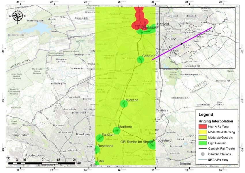
development patterns, travel mode choices, infrastructure costs, redevelopment potential, the health of
natural resources, and other community concerns. Transport planning/evolution and demand usually
respond to how communities’ function spatially (Redman et al., 2013) and in some cases the transport
planning can be used to force spatial change (Browning 2013). Further, Transportation helps shape an
area’s economic health and quality of life. Not only does the transportation system provide for the
mobility of people and goods, it also influences patterns of growth and economic activity by providing
access to land. Transportation planning is more than listing highway and transit projects. It requires
developing strategies for operating, managing, maintaining, and financing the area’s transportation system
to achieve the community’s long-term transportation goals (Burt 2014).
According to Hidalgo (2009), the planning phase is more critical as a type of a system can be referred as
part of planning and the design element is being tied to a management plan as it will involve planning of
routes and stops integrated with frequencies. In line with the above, at the strategic level of planning the
public transport system, long-term stability of a high service quality is required for the public transport
system to influence urban development and to create more sustainable transport patterns (Moyo et al.,
2018). Consequently, Mbatha and Gumbo (2019), state that planning a public transportation system is a
multi-objective problem that includes among others of line planning, timetabling, and vehicle scheduling.
For each of these planning stages, models are known, and advanced solution techniques exist. Some of
the models focus on spatial integration, others on commuter’s convenience. Setting up a transportation
system is usually done by optimizing each of these stages sequentially.

In some instance, the challenge is the physical connectivity, as some transport modes do not enter in
certain location and in some cases; the problem is in the planning phases. For urban public transport to
function well, there are certain elements that need to be considered. In the planning process, there is a
need to find the current demand and the relationship of movement of different public transport modes and
environmental demands. Then a need to formulate the plan, predicting the future travel demand and make
a recommendation to fulfil challenges that might occur. Further, assessing whether the proposal made
satisfactory demand and provide maximum benefit to the community. Monitor existing conditions such as
forecasting future population and employment growth, including assessing projected land uses in the
region and identifying major growth corridors; and Identifying current and projected future transportation
problems and needs and analyzing, through detailed planning studies, various transportation improvement
strategies to address those needs.

Urban Public transportation planning in South Africa has been improving over the years as more
strategies from around the world are adopted by the republic. Several transport modes have been
implemented in order to improve the state of public transport in the country. Bus Rapid Transit & Speed
train are implemented in order to boost quality, efficiency, effectiveness and reliability of the public
transport network. Existence of these modes can be found in Gauteng province.

        2.1 Integrated Transportation Approach
Transport systems are complex and multi-dimensional with many parts that comprise the whole. The
objective of integrated transport planning is to find balance among these dimensions so that planning and
investment decisions contribute optimally to the economic, social, cultural and physical potential of the
transport system and society in general. Integration is a concern with the whole, with common objectives
and agreed desired outcomes. The different options, goals and points of view must be integrated to
identify realistic solutions to community problems. Integrated transport planning is more than coordinated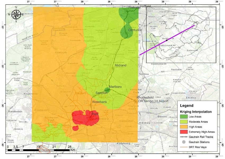
transport planning. It integrates multiple and sometimes-conflicting objectives to reach more sustainable
transport outcomes that contribute to community, industry and government priorities. Further, it is
significant that transportation network is well established from the beginning of the development, designs
should allow roads to link and need enough space for vehicles movement and for potential development
of potential smart transportation. In South Africa, Gauteng implemented smart UPT such as the BRT
system in the City of Tshwane (A Re Yeng bus), Ekurhuleni (Harambe bus) and City of Johannesburg
(Rea Vaya bus). The development of this concept played a good role as it brought more alternatives in
UPT; however, it has reduced the width of the road for other vehicle both public and private transport
leading to traffic congestion on certain peak hours. Hence, environmental challenges may arise and high
human health risk due to time spent on the road by cars releasing noxious gases (Mbatha and Gumbo
2019).

        2.2 Physical and Network Integration

The proximity and ease of access at mode interchanges will greatly enhance public transport services.
Walkways should be carefully designed for passengers to change mode. Passengers should be within a
short walking distance from their residences to a transit stop”. Cities like Hong Kong and Singapore have
been able to build mass transit stops in the heart of neighbourhoods, thereby providing proximity to
residences, offices and retail outlets. Bus and rail systems should be an integrated network and these
separate networks should further complement one another. Feeder services using buses, trams or light rail
should be designed to maximise the patronage of the trunk routes (Liu and Ceder 2017). Network
integration is closely linked to physical integration and both contribute towards the integration of
infrastructure. For instance, it is relatively easy to change between different lines on the London
Underground (tube) network as tube stations have been designed with several interchange points between
tube lines (Moyo and Musakwa 2016). Cities such as Hong Kong, Singapore and Kuala Lumpur have
been able to redesign bus routes so that they feed into and support the mass transit/metro lines (Luk, J.
and Olszewski, P. 2003). Similarly, London’s underground and buses connect with the above ground
heavy rail network to take passengers to their final destinations. An essential part of network integration
involves timetabling services so that intramodal and intermodal services connect efficiently and
effectively.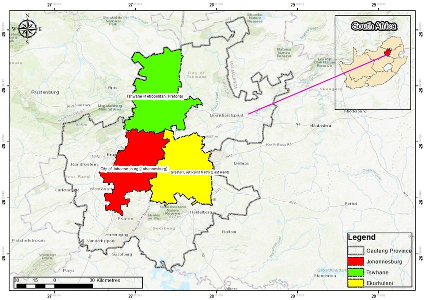
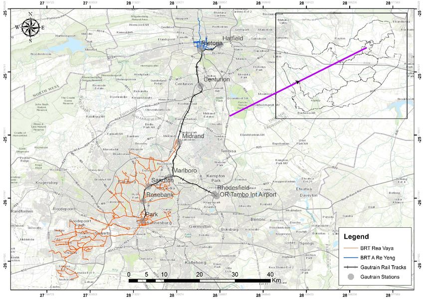
3. STUDY AREA
The study area is Gauteng province which afford many economic opportunities in the republic
with a land cover area of 18 176 m2 and the province is the heart of economic activity.

Figure1: Gauteng Province                                [Source: Author, 2020]

The depicted map above indicates the study area. According to Stats SA (2011), the province population
is 12,27 million. The study focuses on the formal urban public transportation in the province, specifically
Bus Rapid Transit (BRT) system and Gautrain system. Gautrain system operates in selected locations in
the province; however, it services all three Metropolitan cities in the province which include the City of
Johannesburg indicated in red, City of Tshwane indicated in green and Ekurhuleni indicated in yellow.
The BRT system found in the province differ in names and work in the designated cities, and designated
locations. In the City of Tshwane there is A Re Yeng bus, City of Johannesburg there is Rea Vaya bus
and Ekurhuleni there is Harambe bus.
4. METHODOLOGY

A mixed method research design was adopted were qualitative data and spatial data analysis was
used. Various research instruments were employed in the study such as interviews. 10 officials
from different departments such as Johannesburg Road Agency, Department of Transport,
Gautrain and BRT officials and Metropolitan Municipalities transport planners. This assisted to
give the inside of the study if there is a possibility of integrating different modes (bus and train),
and if it is possible to integrate UPT own by different entities. Accordingly, commuters were
also interviewed to understand the commuter patterns and if there are any commuters who
commute to from one Metropolitan city to the next. 20 Commuters who were interviewed are
daily commuters as they might have different experiences taking place daily. Purposive sampling
was adopted as it is necessary to have interviews with informed officials and commuters. ArcGIS
assisted with creating Gautrain rail tracks, BRT routes maps showing locations serviced and
physical integration of the FUPT modes. BRT data (shapefiles), Gautrain data (shapefiles),
interviews and documented studies relating to this study are the source of data. Experimental
analysis was conducted in order to develop a model through kriging interpolation that explains
strategies of identifying suitable location for integrating innovative Urban Public Transport in the
province. Further, content analysis was employed to review previous documented studies.
Secondary data used was obtained from larger data base such as Scopus, Science direct, Sage
and Google scholar.
5. FINDINGS

The results obtained for this study were from both interviews and kriging interpolation. Interviews is one
of the most important technique to collect data as a researcher can gather views of some of the important
role players involved. Interviews conducted with the officials In Gauteng province, indicated that there
are various alternatives of urban public transport modes which include both informal and formal urban
public transport. The use of taxi’s, busses and trains service are in operation. Commuters using the
City/Municipality bus services are currently subsidised, based on multi-journey ticket sales, by Gautrans
in terms of an interim contracts. The subsidy funds originate from the budget of the National Department
of Transport (NDoT) (Department of Transport 2007). City of Johannesburg, City of Tshwane have
implemented the BRT system to improve the state of formal urban public transportation in the province
has existed for a while and Ekurhuleni BRT is still new. Further, there are also trains which include such
types as Metrorail and Gautrain. Metrorail have schedules which are slow but very cheap and on the other
hand Gautrain is very quick in terms of the operating schedules but expensive to use. Implementation of
the Gautrain system was to improve the state of urban public transport as well and connect the three
metropolitan municipalities in the province.

Officials highlighted that when these systems were developed plans put in place locate these innovative
UPT systems not far from one another. With Gautrain operating through all three Metropolitan cities was
to act as a spine to connect with BRT systems in the three cities. Consequently, indicated that the routes
serviced by the BRT busses are mostly the busier routes hence why chosen and there are potential routes
extensions planned to increase the BRT services to other locations in the province. Accordingly, which
this can allow physical integration of numerous routes in the province. Further, commuters indicated that
there is a need of spatial integration between the two systems as some of them travel within these three
Metropolitan cities and an integrated system would be a positive thing for the province UPT network.
Seamless travelling can be integrated, and this will bring less stress when individuals are travelling within
the province.

        5.1Kriging Interpolation

The technique assists with creating a model identifying the locations suitable for BRT and
Gautrain integration in Gauteng province by performing the analysis. This tool is important to
identify hot spots and cold spots of locations concentration.

Figure 2: Gautrain and Rea Vaya Kriging Interpolation [Source: Author, 2020]
The above map figure 2 indicates the innovative UPT suitable locations for physical integration in the
City of Johannesburg between BRT Rea Vaya and Gautrain. In the index different colors are used to show
different concentrations. All the areas overlaid by the location concentration indicate that there is
possibility for physical integration and possibility for future expansions of these modes of innovative
UPT could be developed.
Physically suitable Percentage of suitable locations
Location Concentration
integration locations for integration%
Red 15 Extremely high Concentration
Orange 40 High Concentration
Lime Green 30 Moderate Concentration
Green 15 Low Concentration
Table 1: Suitable locations for integration in COJ [Source: Author, 2020]
In the City of Johannesburg, Park station, and close by areas there is extremely high concentration which
is indicated in red. These locations indicated in red shows that it is suitable for physical integration in the
city between Rea Vaya and Gautrain whereby commuters can switch smoothly from bus to train.
However, extremely high areas in the city are very low in percentages which are only identified in Park
station and close by areas. High concentration areas have a higher concentration percentage which is
identified in many locations of the Gauteng province moving towards Roodepoort whereby the future
Gautrain stations are proposed and moving towards Ekurhuleni close to Boksburg were there are also
future expansion for Gautrain station. Rea Vaya services some other locations in Roodepoort which this
indicate that when the Gautrain station is developed in Roodepoort, there is a possibility of future
physical integration between Gautrain and Rea Vaya. Consequently, Moderate concentrated areas show a
slightly possibility of integration as there is transport network of either Gautrain or Rea Vaya. This
indicate that there is a possibility of whereby future stations of these innovate UPT systems could be
developed. Further, low concentrated locations indicate that possibilities for physical integration of Rea
Vaya and Gautrain are unlikely to happen. Below it is the map indicating suitable locations for physical
locations in the City of Tshwane.Figure 3: Gautrain and A Re Yeng Kriging Interpolation [Source: Author, 2020]
The above map figure 3 shows Gautrain and A Re Yeng kriging interpolation. This analysis was
conducted to identify locations that are suitable for physical integration in the City of Tshwane between A
Re Yeng and Gautrain. Gautrain rail track, Gautrain stations and BRT A Re Yeng routes were all added to
make sense of the suitable location areas for physical integration.
Physically suitable Percentage of suitable locations
Location Concentration
integration locations for integration%
Green 20 High Gautrain Concentration
Yellow 5 Moderate A Re Yeng Concentration
Red 20 High A Re Yeng Concentration
Lime green 55 Moderate Gautrain Concentration
Table 2: Suitable locations for integration in COT [Source: Author, 2020]
The above index of location concentration highlights that most of the areas that are concentrated are close
to the Gautrain rail track, Gautrain stations, A Re Yeng bus routes and A Re Yeng bus stations. All the
areas far from this have 0% of concentration where there could be a possibility of innovative UPT
integration. However, if in the locations where there is concentration could have expansion of rail track,
roads and stations there could be more concentration around the Gauteng province and more areas for
suitable physical integration could be located. In the City of Tshwane, a high A Re Yeng concentration
area and high Gautrain concentration area can be identified. Where these two-high innovative UPT
concentration connect, it indicates the suitable areas for physical integration in the City of Tshwane. Mostof the locations with high concentration which include Gautrain stations and A Re Yeng station refers to possibility of integration as there are existing stations around those locations. Moderate Gautrain concentration also indicate a possibility of where more station can be developed in the province and a possibility of physical integration could take place. Below it is the integrated network for innovative UPT in the Gauteng province. Figure 4: Integrated BRT and Gautrain Network [Source: Author, 2020] The above map indicates the integrated innovative UPT network of A Re Yeng bus in the City of Tshwane, Rea Vaya bus in the City of Johannesburg and Gautrain moving around all three Metropolitan Municipalities. As mentioned earlier, there is possibility of integrating innovative UPT in Gauteng province as there is spatial integration on some locations in the province. There is a possibility for seamless travelling in Gauteng province. Rea Vaya bus in the City of Johannesburg connects physically with numerous Gautrain stations, A Re Yeng bus in the City of Tshwane physically connects with two Gautrain stations and Harambe bus is still new and only connects physically with one station in Ekurhuleni. Integrating BRT system and Gautrain system will create reliability in UPT and easy access to different locations in the province. There are people travelling daily around the three Metropolitan cities for different reasons most is work and school. Commuters travelling from City of Tshwane to City of Johannesburg can use A Re Yeng bus from origin (home) switch modes at Gautrain station (Hatfield or Pretoria central) to a Gautrain travelling to the City of Johannesburg. Consequently, when commuters get to the City of Johannesburg can use Rea Vaya from the integrated areas between BRT and Gautrain to travel to their final destination (work, school or place of interest). Further, Rea Vaya service a larger area in the City of Johannesburg including South Western Township (SOWETO), Tembisa, Rosebank etc.
Therefore, there are commuters from other locations in SOWETO travelling to Ekurhuleni and City of
Tshwane. Commuters from Soweto, Tembisa can use Reya Vaya travelling to City of Tshwane and
Ekurhuleni. Consequently, switch in between at park station to Ekurhuleni and City of Tshwane. When
commuters reach City of Tswane can switch to A Re Yeng bus to their destination (work, school, home or
place of interest) and on the other hand when commuters reach Ekurhuleni can switch to Harambe bus to
their destination.

6. CONCLUSION
South Africa is a developing country with good functioning UPT modes. Gauteng province has developed
two of the world class UPT systems which are BRT system and Gauteng System. However, the study has
indicated that these system are currently not integrated which leaves a huge gab to commuters who uses
both UPT systems to reach desired destination. Therefore a experimental analysis using kriging
interpolation was perfomed to identify locations that can be suitable for physical integration in the
Gauteng province. In the City of Tshwane the results have shown a possibility for physical integration
between A Re Yeng and Gautrain in Pretoria Central and Hatfield station. In Johannesburg the results
have also shown a possibility for physical integration in Park station and other areas close by, and in
Ekurhuleni Harambe is still small but with time it will increase and it will assist to connect Ekurhuleni
Metropolitan with the two Metropolitan cities (COT and COJ). With this, it shows that there is a
possibility of bringing this services together and create one transport network that will function across the
province. Further, the analysis also indicated areas which are possible for future expansion for
implemantation of stations to expand the transport network.

7. URBAN PUBLIC TRANSPORT INTEGRATION MODEL

                                                  Kriging
                                               Interpolation
Figure 5: Spatial integration UPT model [Source: Author, 2020] Figure 5 explains the model regarding how to identify suitable locations for integration between the BRT system and Gautrain system. Kriging interpolation was performed to give suitable locations and help to currently identify cold and hot spots of locations that need formal urban public transport services. When kriging interpolation was performed, first, Gautrain shapefile and Rea Vaya shapefiles were combined to produce desired locations for integration in the City of Johannesburg. Second, Gautrain shapefiles and A Re Yeng shapefiles were combined also to produce desired locations for integration in the City of Tshwane. Kriging interpolation analysis was performed with an ARCGIS software. Lastly, the analysis also revealed locations that need service for expansion of this UPT network. Accordingly, an integrated network map was designed to show the integration of BRT to Gautrain from the City of Johannesburg to the City of Tshwane in figure 4. 8. RECOMMENDATIONS Adoption of integrated UPT network across the province is significant to attract more ridership and reduce private vehicle ownership on the roads resulting in less car accidents, less GHG emmision produced and producing smooth travelling from one city to the next. Especially in South Africa private car ownership regularly increases every year. The model used for the study can be adopted in order to identify UPT integration suitable locaions. 9. FUTURE STUDIES Integrated UPT system allow for reliable, effective, convinient, safe, efficient and smart public transport in a certain place. The study focused on integrating spatially innovative UPT services in Gauteng province with the primary focus on both BRT system and Gautrain system. If there is a possibility of integrating these systems the above mentioned factors will take place. Therefore, there will be a need for such innovative UPT network connecting all nine provinces in the country to create seamless travelling with well functioning spatial integration. Future work, will look at integrating UPT network in South Africa. 10. REFERENCES
Browning     B     (2013)   Search     for     solution   to  transport  blues.  (Available at:
https://www.pressreader.com/south-africa/pretoria-news/20170713/281775629200166 . [Accessed 24
January 2020]).

Burt, M., Cuddy, M. and Razo M (2014) Big Data’s Implications for Transportation Operations,
Cambridge, U.S. Department of Transportation.

Department of Transport (2007). Rural Transport Strategy for South Africa. Available
from:http://www.gov.za/sites/www.gov.za/files/rural_transport_strategy_%20for_sa2007new_0.pdf.
(Accessed 27 January 2020).
Hidalgo D (2009) “Citywide transit integration in a large city: the interligado system of sao paulo,
Brazil.” Transp. Res. Rec. J. Transp. Res. Board 2114: 19–27. Transportation Research Board of the
National Academies, Washington, D.C.
Liu, T. and Ceder, A. (2017). Integrated Public Transport Timetable Synchronization and Vehicle
Scheduling with Demand Assignment: A Bi-objective Bi-level Model Using Deficit Function Approach.
22nd International Symposium on Transportation and Traffic Theory. Transportation Research Procedia.
23, 341-361.
Luk, J., Olszewski, P., 2003. Integrated public transport in Singapore and Hong Kong. Road Transp. Res.
12 (4), 41–51.
Mbatha, S. and Gumbo, T. (2019). Establishing the State of Spatial Integratedness of Innovative Public
Transport Systems in Gauteng, South Africa. Is this the real world? Perfect smart cities vs real emotional
cities. Proceedings of the 24th International conference on Urban Planning and Regional Development in
the information society. 24, pp. 385- 390.
Moyo, T. and Musakwa, W., 2016. USING CROWDSOURCED DATA (TWITTER & FACEBOOK)
TO DELINEATE THE ORIGIN AND DESTINATION OF COMMUTERS OF THE GAUTRAIN
PUBLIC TRANSIT SYSTEM IN SOUTH AFRICA. ISPRS Annals of Photogrammetry, Remote Sensing
& Spatial Information Sciences, 3(2).
Moyo, T., Musakwa, W. and Mokoena, B.T., 2018. AN ANALYSIS TO INVESTIGATE SPATIAL
COGNITIVE         FACTORS        WHICH   INFLUENCE     CYCLING      PATTERNS       IN
JOHANNESBURG. International Archives of the Photogrammetry, Remote Sensing and Spatial
Information Sciences, 42(4/W11).

Redman L, Friman M, Garling T and Hartig T (2013) “Quality attributes of public transport that attract
car users: are search review.” Transp.Policy 25: 119–127.
You can also read