Inclusionary Trail Planning Toolkit - A guide to planning and programming equitable trail networks - Pennsylvania ...
←
→
Page content transcription
If your browser does not render page correctly, please read the page content below
Inclusionary Trail
               Planning
                Toolkit

A guide to planning and
programming equitable trail networks

                           Funding for this report was provided by the
Contents
                                                                                                Foreword													1

                                                                                                Section 1: Introduction 										2
                                                                                                Inclusionary Planning											2
                                                                                                Equitable Planning											3
                                                                                                Green Gentrification											 4

                                                                                                Section 2: Case Studies of Inclusionary Trail Planning					             8
                                                                                                Camden, New Jersey											8
                                                                                                Philadelphia, Pennsylvania										11
                                                                                                Washington, DC												21
                                                                                                Examples of Successful Programming for Inclusive Trails						 23

                                                                                                Section 3: Tools for Planning in Community							                       27
                                                                                                Community Organizing for Trail Planning								27
                                                                                                Forge Alliances and Building a Base									27
                                                                                                Establishing Buy-in											28
                                                                                                Leadership Development										29
                                                                                                Understanding the Community: Using Data								31
                                                                                                Understanding the Community: Community Mapping						32
                                                                                                Understanding the Community: Employing Social Justice Frameworks			      32
                                                                                                Understanding the Community: Is My Community Prone to Gentrification?			 33
                                                                                                Planning Events: Origins of Event									36
                                                                                                Planning Events: Outreach for Events								36
                                                                                                Planning Events: Event Logistics 									37
                                                                                                Implementation of the Trail: Construction Phase							38
                                                                                                Implementation of the Trail: Celebrate the Opening 						                39
                                                                                                Implementation of the Trail: Program the Trail							                    39
                                                                                                Implementation of the Trail: Job Creation								                        40
                                                                                                Institutional Change 											                                         40

                                                                                                Appendix A: Resources for participatory planning events				             43
                                                                                                Appendix B: Resources for Data Collection 							                       46
                                                                                                Appendix C: Midwest Academy Racial Justice and Equity Framework		       47
                                                                                                Appendix D: Race Forward, Racial Equity Impact Assessments			           48
                                                                                                Appendix E: Addressing Gentrification in Communities				                50
                                                                                                Appendix F: Training Resources									                                 51
                                                                                                Appendix G: Summary of interviews								                               53

This report was prepared by Julia Raskin on behalf of the Pennsylvania Environmental Council.
Special thanks to the Inclusive Planning Working Group for their expertise, guidance, and
time: Shoshanna Akins, Eleanor Horne, Valeria Galarza, Rachel Griffith, and Daniel Paschall.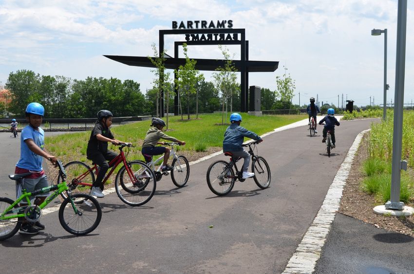
“The people have a right to clean air, pure water, and to the preservation of the natural, scenic, historic and
esthetic values of the environment. Pennsylvania’s public natural resources are the common property of
all the people, including generations yet to come. As trustee of these resources, the Commonwealth shall
conserve and maintain them for the benefit of all the people.”

Article 1, Section 27 of the Pennsylvania Constitution

Foreword
At the Pennsylvania Environmental Council (PEC), we believe that having meaningful experiences in nature
is key to developing a love for natural resources and fostering a stewardship ethic. While opportunities
for outdoor recreation are not equal across the Commonwealth, PEC is committed to democratizing
recreation and active transportation for all by supporting the development of trails that are within reach of
all Pennsylvanians. We are not alone in this pursuit. We share this goal with the Pennsylvania Department
of Conversation and Natural Resources as articulated in the State’s award-wining State Comprehensive
Outdoor Recreation Plan.

Through our work, we are acutely aware that many communities are left out of traditional engagement for
planning and design of trails. The voices of people of color, low-income communities, differently-abled
people, youth, and seniors are often missing from trail conversations in both urban and rural areas across
Pennsylvania.

Our awareness incited action. With the help of a working group of Circuit Trail members, we sought to
gather and share effective tools for inclusive trail planning. This report is the result of that effort. While it is
designed to educate trail building and programming professionals in the Circuit Trails Coalition, the tools
are applicable beyond our network. We first looked at case studies of inclusive trail planning efforts in areas
similar to the Circuit Trails region, interviewed people involved in the projects, and, with equity in mind, took
a critical look at how these projects unfolded. Lessons learned were informed by both the successes and
challenges of respected practitioners in Atlanta, Washington DC, Camden, and Philadelphia.

Our major take-aways:
  • There are tangible and intangible barriers that keep some individuals and whole communities from
      participating in planning processes;
  • Language barriers, demands of jobs and family, inflexible schedules, and limited transportation
      options can keep people from participating in community meetings and events;
  • The struggle to be heard, the belief that one’s experience will not be taken seriously, and the lack of
      familiar faces at public meetings are realities that keep some communities from feeling included in
      planning processes.

While the experience of Pennsylvania’s natural beauty is an inheritance of all residents and access to these
spaces is critical, the reality is a work in progress. The tools in this report aim to help trail planners and
environmental educators overcome these barriers to participation in thoughtful ways. The goal is always to
build and maintain places where all Pennsylvanians feel genuinely welcome to embrace that inheritance.

Davitt Woodwell                          Patrick Starr                             Lizzie Hessek
President                                Executive Vice President                  Program Manager

                                               Inclusionary Trail Planning Tool Kit | Pennsylvania Environmental Council 1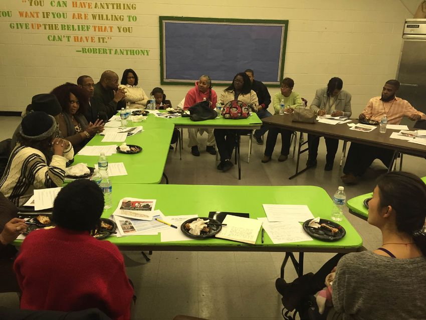
Section 1: Introduction
help address their needs. Gathering useful feedback and new information from participants requires respecting
community culture. The approaches will vary from project to project. Outreach goals and methods are shaped
by whether or not the project was conceived from within the community or if its location was predetermined.
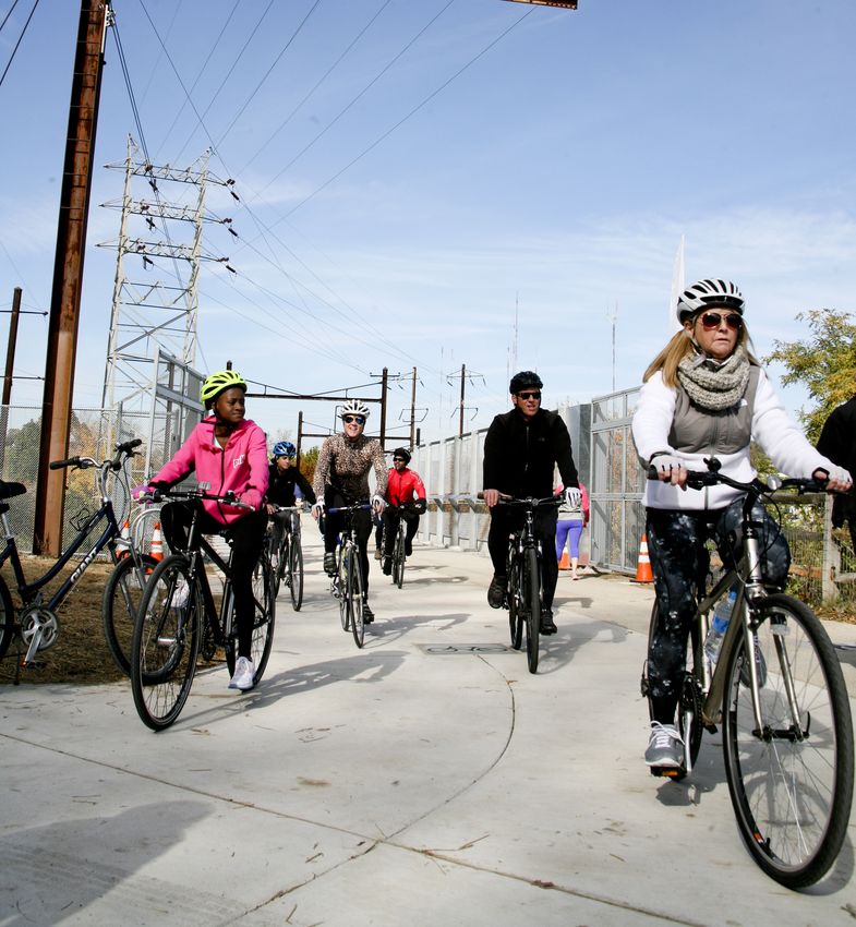
Trails and parks are community assets that ideally serve the needs of their surrounding communities. These To ensure long-term inclusion and access for everyone, outreach should continue beyond the planning process
spaces provide the opportunity for exercise, active transportation, outdoor recreation, and gathering together. and activate the space through community programming and stewardship. Similar to the planning process,
Studies show that access to green space improves health and wellbeing while also providing environmental building successful programs involves prioritizing the needs and desires of the surrounding communities.
benefits such as retaining stormwater, lowering ambient temperature, and restoring animal habitat1,2. Trails
also improve connectivity between neighborhoods and provide alternative transportation options. Considering To accomplish these steps, support from community groups and community leaders is critical. These groups,
these benefits and opportunities, it is no surprise that green spaces are playing an important role in the revital- including civic associations, non-profits, sports teams, businesses, and even informal social circles and grass-
ization of post-industrial cities nationwide3. From the Capital Crescent Trail in Washington, DC to Railroad Park roots(s) organizers, have important neighborhood connections and address pertinent community issues.
in Birmingham, Alabama, parks have improved the local economy and attracted new development. Leveraging community relationships adds capacity to the project by broadening opportunities for community
outreach. Pro-actively building relationships with these groups is not only key to an inclusive planning process,
Multi-use trails can encourage people to be active and feel connected to their neighborhood. As trails improve it can also increase the community’s capacity to address other needs in the neighborhood. Providing mutual
connectivity between neighborhoods, it becomes easier and more desirable for people and amenities to move support to community partners is an important aspect of building and maintaining these relationships.
into new spaces along the trail. Indeed, access to green space with welcoming, low-stress facilities for walking
and biking are desirable characteristics of a neighborhood and attract new development in the area. While This report will discuss how community organizing principles and practices can help organizations and agencies
new development can have very positive effects in a community, new amenities may come with the unintended connect with the communities they are working in to achieve comprehensive community engagement. As a
consequences of increasing property values, displacing residents, and shifting demographics. This report does lack of resources is a common obstacle to achieving an inclusive process, Section Three of this report outlines
not discuss the geographic distribution of trails and parks in depth, but it deals with community engagement low cost outreach methods and emphasizes the importance of leveraging existing community based resources.
around open space development that focuses on improving the quality of life for existing residents and creating
more equitable spaces by prioritizing historically disenfranchised groups. Equitable Planning
For new trails and parks to best serve existing communities, it is important to plan them with support and When equity is achieved, people put in what they can and get back what they need.
input from the current surrounding community. The process of achieving community buy-in is not always clear,
however. As planners seek to build new or improved public spaces, it is important to consider all the potential “Equity” has many meanings. In this report, the term “equity” refers to a social justice tool and a human rights
effects these new spaces could have on the surrounding communities. Non-profit and advocacy organizations principle for fair resource distribution and access to resources. In this definition, equity does not mean equality,
play an important role in supporting the outreach efforts of urban planners by providing a critical link to the which proposes giving everyone the same treatment. Equity focuses on access, which changes depending on
community. This report will use case studies to outline best practices in inclusionary planning, and will provide a person’s life circumstance. Access can change based on socioeconomic status, race, geography, or physical
a tool kit to help non-profit organizations and planning agencies do inclusive trail development. ability. It is ultimately rooted in a historic lack of access to resources. When equity is achieved, people, organi-
zations, and systems put in the resources they are able to contribute and get back the resources that they need.
Inclusionary Planning
The status quo expects disenfranchised groups to work harder in order to access resources that are more readily
As the urban renaissance continues, public agencies and organizations nationwide are focusing on inclusion available to privileged groups. Because trails challenge this status quo by providing free spaces for recreation
and equity as they embark on new developments and revitalization efforts in historically underserved neighbor- and transportation, trail developers are
hoods. In this context, a successful planning process involves engaging the diversity of neighbors who surround well positioned to achieve equity through Capital Trails Coalition Commitment to Equity
the park, and working towards their vision for their community. Inclusion and equity are related but not identical inclusive planning. It will require consistent
The Capital Trails Coalition recognizes
concepts. The equitable distribution of parks and trails prioritizes neighborhoods that have the highest need for effort to prioritize disenfranchised groups
long-standing and current societal inequities that
these amenities. Inclusionary planning, on the other hand, prioritizes the participation of residents who have and employ the right tools in order to have their roots in generations of unjust structural
been traditionally underrepresented in the trail planning process. When inclusive planning is successful, new or achieve equitable access for all. barriers, policies, practices, attitudes, language
retrofitted trails and parks become community assets that reflect the history and desires of the local residents. and cultural messages have disproportionately
Parks, trails and public space have varied impacted many minority groups.
An inclusive trail planning process must be created within the context of a neighborhood’s geography, levels of access depending on location,
demographics, and history. Traditional planning events often cater to people who have the time and resources maintenance, geography, transportation Therefore, the Coalition will promote an equitable
to attend community events and to those who have a predisposed awareness of new capital projects due to options, lighting, ADA compliance, and trails network by analyzing the unique challenges and circumstances
their profession or other networks. Planners and advocates can make informed decisions based on community rule enforcement. Many of these obstacles impacting specific populations’ mobility, safety and connectivity
context in order to challenge this status quo and foster an accessible and inclusive planning process. can cause real and perceived safety needs.
concerns. When designing these spaces,
The Coalition will use this information to offer and advocate for
The early stages of trail planning include pro-actively learning from the existing community how a trail could planners consider access not only to the solutions so that the trail network more effectively serves all residents,
physical space but also to the planning including current and potential trail users.
1. South EC, Hohl BC, Kondo MC, MacDonald JM, Branas CC. “Effect of Greening Vacant Land on Mental Health of Community-Dwelling Adults A
Cluster Randomized Trial.” JAMA Network Open. 2018;1(3):e180298. doi:10.1001/jamanetworkopen.2018.0298 process. Meaningful participation from
community groups can identify potential The Coalition will also use this lens pro-actively to influence its own
2. Chiesura, Anna. The role of urban parks for the sustainable city. Landscape and Urban Planning, Volume 68, Issue 1, 2004, pp. 129-138.
barriers to access and help planners design structure and decision making framework.
3. Larson LR, Jennings V, Cloutier SA. “Public Parks and Wellbeing in Urban Areas of the United States.” PLoS ONE. 2016, 11(4): e0153211. https://doi. a welcoming space.
org/10.1371/journal.pone.0153211
2 Inclusionary Trail Planning Tool Kit | Pennsylvania Environmental Council Inclusionary Trail Planning Tool Kit | Pennsylvania Environmental Council 3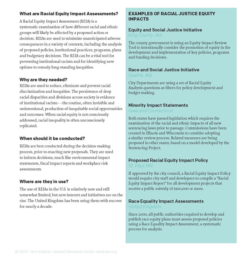
Building an accessible public space requires not only design solutions, but also inclusive outreach with community                                      following year the first mill to use water power from the Canal opened. By 1860 Manayunk was a major world
 members, local institutions and city agencies. If outreach and engagement is successful, a relationship is culti-                                       textile center, making it a home to the working class of the time. Over the next 50 years, droughts, floods, and
 vated between the community and the space itself and a sense of stewardship is instilled in the people who                                              competition from the Reading Railroad dramatically decreased productivity on Manayunk’s Schuylkill Canal.
 frequent the park or trail. Cultivating stewardship instills a sense of community ownership, organically creating                                       The 1920’s saw a major decline in the textile industry, leading to decades of job loss and a declining economy9.
 avenues to access.
                                                                                                                                                         Starting in the 1970’s, government officials began working to make Manayunk a tourist destination by capital-
  Green Gentrification                                                                                                                                   izing on the river and the quaint downtown Main Street. Mayor Frank Rizzo worked with City Council to secure
                                                                                                                                                         $2 million dollars to dredge and spruce up the canal, a precursor to the tow path construction a decade later.
 National trends show that people are moving back to cities in search of an urban lifestyle with access to                                               Investment on Main Street continued with the installation of new sidewalks, trees, and the creation of a park
 employment, public transportation, nightlife and shopping4,5. This influx has led to increased spending on infra-                                       overlooking the canal. The new park opened access to the river, making the area more desirable for businesses
 structure such as housing, parks, bike lanes, and public transit stations6. As urban neighborhoods have become                                          and new homeowners. To continue stimulating development, the City of Philadelphia offered grants for building
 more attractive to newcomers, the cost of living has increased in a process called gentrification. Thoughtful and                                       restoration on Main Street10.
 ethical gentrification can be a goal in some communities. In other communities, unchecked gentrification has
 led to the displacement of existing communities. The effects of unintended community displacement are being                                             In 1979, the towpath was constructed and through the 1980’s and 1990’s, Manayunk saw an uptick in redevel-
 felt nationwide, and trails and parks can play a role in these processes.                                                                               opment. The Friends of the Manayunk Canal formed in 1996 to protect the integrity of the watershed, bringing
                                                                                                                                                         more attention and capital to the waterfront11. The
 “Green Gentrification” refers to the role of environmental discourse and urban sustainability, which includes the                                       combination of river access, proximity to downtown,
 planning of parks and trails, in driving up property values and displacing low-income residents. The environ-                                           and reasonably priced housing, supported its recovery
 mental movement, with support from grassroots organizations, government agencies, and private companies,                                                as a retail cluster with a lively nightlife and scenic hilltop
 is succeeding in its efforts to encourage ecologically responsible urban development. While some of these                                               views12.
 projects have positive environmental outcomes, sustainable living is now a marketable feature that contributes
 to increasing property values. In this sense, the sustainability dialogue rarely addresses the question: “who                                           Between 1980 and the present day, the revitalization
 will benefit from neighborhood improvements and how7,8?” This question speaks directly to the issue of park                                             of Manayunk’s economy shifted the historical working
 and trail access by asking advocates and planners to consider whom they hope to serve and how they plan to                                              class demographics of the neighborhood. According
 achieve equitable development.                                                                                                                          to a gentrification map by Governing Magazine, since
                                                                                                                                                         1990 housing prices have increased by 109% and the
 This report intends to provide concepts, tools, and examples that can guide organizations and agencies in deter-                                        number of residents holding bachelor’s degrees has
 mining who will benefit from neighborhood improvements, and how this knowledge can shape the planning                                                   increased by almost 20%13. Manayunk’s story reflects a
 process. While not all communities face the same threat of gentrification, inclusionary planning practices are                                          planning strategy designed not for current community
 relevant to all outreach efforts engaging people of diverse socio-economic, racial, and ethnic backgrounds in                                           members, but rather for newcomers attracted by new
 the design, planning, and development of public space. The report will also examine the factors to consider                                             development and recreational amenities. While the
 when determining if a neighborhood is susceptible to gentrification. In Section Two, case studies illustrate the                                        “greening of Manayunk” was positive for the economy
 concept of “Just Green Enough”: a low-impact approach to planning that enhances connectivity within the                                                 and for the environment, the negative externality of
 trail system by providing safe and active transportation routes, but is not a driver of real estate speculation and                                     displacement directly impacted the community. As
 development.                                                                                                                                            affordability shifted, tension grew between the working
                                                                                                                                                         class in the neighborhood and the new residents
                                                                                                                                                         moving in to enjoy the amenities. The new businesses               Schuylkill River Town event on the Manayunk Towpath
 When trails are developed without the necessary safeguards against displacement, they can create immediate
 and long-lasting repercussions on the demographics of a community. The examples of the Schuylkill Canal                                                 on Main Street were not locally owned and did not hire residents of Manayunk, further divorcing the commercial
 Towpath in Manayunk and the Atlanta BeltLine demonstrate the unintended consequences of trail development                                               area from long-time residents. Irene Madrak, Executive Director of North Lights Community Center and a
 in neighborhoods liable to gentrification.                                                                                                              life-time resident of Manayunk, commented that “the residents feel snubbed on Main Street.14” As we plan new
                                                                                                                                                         trails and parks, preemptively acknowledging and addressing impacts to the surrounding community may be
 Manayunk, Canal Towpath and Schuylkill River Trail                                                                                                      the difference between strengthening the community and dividing it.

 A major textile center in the nineteenth century, Manayunk once had a booming industrial economy, but declined
 after the Civil War. In 1818, the Manayunk section of the Schuylkill Canal opened to maritime traffic, and the                                          9. Friends of the Manayunk Canal, A Brief History of the Canal: 1761-1999 Retrieved from http://www.manayunkcanal.org/History/27/

                                                                                                                                                         10. Fisher, Geraldine A., “The Gentrification of Manayunk”. Theses (Historic Preservation). 2006; Retrieved from: http://repository.upenn.edu/hp_the-
 4. Retrieved from U.S. Census Data https://www.census.gov/newsroom/releases/archives/2010_census/cb12-50.html                                           ses/5

 5. Rosen, Daniel “More People, More Infrastructure: The Big City Challenge” Blueprint by CBRE 2017 Retrieved from https://blueprint.cbre.com/more-      11. Friends of the Manayunk Canal, A Brief History of the Canal: 1761-1999 Retrieved from http://www.manayunkcanal.org/History/27/
 people-more-infrastructure-the-big-city-challenge/
                                                                                                                                                         12. Lin, Jeffrey, “Understanding Gentrification’s Causes”, Federal Reserve Bank of Philadelphia Research Department, Economic Insights, 2017, vol. 2,
 6. Checker, Melissa (2011) “Wiped Out by the ‘Greenwave’: Environmental Gentrification and the Paradoxical Politics of Urban Sustainability” City and   issue 3, 9-17
 Society 210-229
                                                                                                                                                         13. Philadelphia Gentrification Maps and Data Retrieved from: http://www.governing.com/gov-data/philadelphia-gentrification-maps-demographic-da-
 7. Ibid                                                                                                                                                 ta.html

 8. Swyngedouw, Eric “Impossible/Undesirable Sustainability and the Post-Political Condition” The Sustainable Development Paradox, ed. Krueger J.R.      14. Fisher, Geraldine A., “The Gentrification of Manayunk”. Theses (Historic Preservation). 2006; Retrieved from: http://repository.upenn.edu/hp_the-
 and Gibbs D, (New York: Guilford Press, 2007), 13–40                                                                                                    ses/5

4 Inclusionary Trail Planning Tool Kit | Pennsylvania Environmental Council                                                                                                                                            Inclusionary Trail Planning Tool Kit | Pennsylvania Environmental Council 5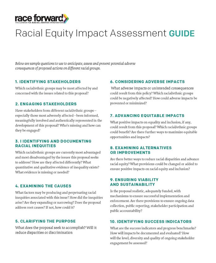
Atlanta BeltLine

 The Atlanta BeltLine – a 22-mile transit greenway transforming old railroad corridors with light-rail transit, parks,
 and multi-use trails through 45 historic neighborhoods – illustrates the difficulty of maintaining affordability
 around new trails in areas prime for gentrification. The new greenway is still in progress, and the Atlanta BeltLine
 Partnership has undergone multiple phases of community outreach and engagement to create community
 buy-in and preempt problems of affordability and displacement15. However, the strong economic driver of the
 multi-modal project, along with the demand for market rate housing, has led to affordability being overlooked
 in favor of development around this attractive new community amenity. As a result, people have become
 dismayed by the planning process and concerned about displacement16.

 The Atlanta BeltLine’s blueprint came from Ryan Gravel’s 1999 joint master’s thesis in Architecture and City
 Planning from Georgia Tech. Only three years after graduating, Ryan teamed up with city council woman Cathy
 Woolard to form Friends of the BeltLine, a group dedicated to building grassroots support for the project
 throughout the city. As the project garnered support and built momentum, Atlanta Mayor Shirley Franklin                                       William Massey’s Tony Comes Home installation was the culmination of Atlanta’s “Art of Reconciliation”project on the BeltLine
 created the Atlanta BeltLine Partnership in 2005 to galvanize private sector and citizen support for BeltLine                                 Source: www.williammasseyart.com
 redevelopment. After a 6-month planning process that engaged 10,000 Atlanta residents, the Atlanta BeltLine
 Redevelopment Plan was approved17.                                                                                                            a local perspective and honor neighborhood history21.
                                                                                                                                               With luxury construction appearing on the new trail, rents and taxes increased dramatically and residents feared
 Plans moved quickly when, in 2006, City Council approved the Five Year Work Plan, and the following year the                                  displacement. As a result, BeltLine creator Ryan Gravel resigned from the Partnership Board in 2016, and
 Atlanta BeltLine Partnership launched public tours of 45 neighborhoods along the BeltLine. That same year the                                 others lost faith that BeltLine Inc. could live up to its affordable housing promise22. Research from Georgia State
 BeltLine Affordable Housing Advisory Board (BAHAB) was established, and after further community outreach                                      University anticipated this problem in 2007, when land prices were already increasing in the predominantly
 and planning, the first trail segment opened in 2008. Atlanta BeltLine Inc., the agency in charge of the project’s                            black, middle class, and lower-income neighborhoods in the BeltLine’s southern section, a trend that continues
 development, committed to creating 5,600 affordable houses and apartments by 2030 — a goal so important                                       today.
 that City Council put it into law18.
                                                                                                                                               To address this trend in 2007, BeltLine Inc. created an affordable housing trust fund that was expected to raise
 Unfortunately, 2008’s economic recession changed the course for affordability along the BeltLine. Halfway                                     $120 million over 25 years from city-issued construction bonds. However, due to the Great Recession, the bond
 through its scheduled timeline to completion, Atlanta BeltLine Inc. was only able to build 131 affordable homes.                              raised $55 million less than planned23. Philanthropists were only willing to help fund trail amenities, so the
 Many of these homes were built far away from job centers and top schools and were only planned to be kept                                     Partnership Board was able to raise $38 million for parks and trails but still had insufficient funding for affordable
 affordable for 15 years. The company decreased spending on affordable housing as the city entered a housing                                   housing.
                                            crisis19, and BAHAB labeled the affordability problem as an “accel-
                                            erating threat20.”                                                                                 Since BeltLine investment began 12 years ago, rents have risen by 59 percent in the Old Fourth Ward, an east
                                                                                                                                               side neighborhood where the first trail segment opened24. Currently there is no set plan to address the issue,
                                                  The first trail segment also serves as a linear art gallery. Finding the                     and many experts have claimed that even the original 5,600 affordable units would not adequately address the
                                                  balance between artistic rigor and community input while selecting                           problem of rising rents. In June, the Executive Director of BeltLine Inc., Brian McGowan, called for the legis-
                                                  artists to install pieces along the trail was also an iterative process.                     lation to be reworked in order to increase the amount of affordable units to 10,000 homes25.
                                                  The first artist selections left the community feeling cut out of the
                                                  process, and one art piece stirred up enough controversy that the                            The Atlanta BeltLine was a visionary project ahead of its time, and thus presents several lessons about devel-
                                                  BeltLine revamped their process for choosing artists to better reflect                       opment leading to displacement. The project is still far from complete, and if trail planners develop the political
                                                                                                                                               will to do the hard work, the Atlanta BeltLine can still live up to its promise to create a trail that benefits all
                                                  15. Atlanta Beltline Project History World-Class from Concept to Completion. Retrieved
                                                  from https://beltline.org/progress/progress/project-history/                                 communities. While the project does not necessarily reflect the economic and social realities of many commu-
                                                                                                                                               nities surrounding the Circuit Trails, it illustrates the challenge of maintaining affordability in communities that
                                                  16. Mariano, Willoughby; Conway, Lindsey; Ondieki, Anastaciah. How the Atlanta Beltline
                                                  broke its promise on affordable housing. 2017; The Atlanta Journal-Constitution. Retrieved   offer green space and sustainable transportation options. Likewise, it demonstrates the importance of keeping
                                                  from                                                                                         community needs central to the planning process.
                                                  https://www.myajc.com/news/local/how-the-atlanta-beltline-broke-its-promise-afford-
                                                  able-housing/0VXnu1BlYC0IbA9U4u2CEM/

                                                  17. Atlanta Beltline Project History World-Class from Concept to Completion. Retrieved       21. Miranda Kyle, Philadelphia, Panel Event at MuraLAB: Arts, Infrastructure, and Equity, July 19 2018
                                                  from https://beltline.org/progress/progress/project-history/
                                                                                                                                               22. Mariano, Willoughby; Conway, Lindsey; Ondieki, Anastaciah. How the Atlanta Beltline broke its promise on affordable housing. 2017; The Atlanta
                                                  18. Mariano, Willoughby; Conway, Lindsey; Ondieki, Anastaciah. How the Atlanta Beltline      Journal-Constitution. Retrieved from
                                                  broke its promise on affordable housing. 2017; The Atlanta Journal-Constitution. Retrieved   https://www.myajc.com/news/local/how-the-atlanta-beltline-broke-its-promise-affordable-housing/0VXnu1BlYC0IbA9U4u2CEM/
                                                  from
                                                  https://www.myajc.com/news/local/how-the-atlanta-beltline-broke-its-promise-afford-          23. Ibid
                                                  able-housing/0VXnu1BlYC0IbA9U4u2CEM/
                                                                                                                                               24. Ibid
                                                  19. Ibid
                                                                                                                                               25. Keenan, Sean. Beltline CEO: 5,600 affordable housing units won’t cut it; we want 10,000. Curbed Atlanta 2018; Retrieved from https://atlanta.
 Source: Georgia State Signal                     20. Ibid                                                                                     curbed.com/2018/6/6/17432062/beltline-ceo-affordable-housing-units-10000

6 Inclusionary Trail Planning Tool Kit | Pennsylvania Environmental Council                                                                                                                                  Inclusionary Trail Planning Tool Kit | Pennsylvania Environmental Council 7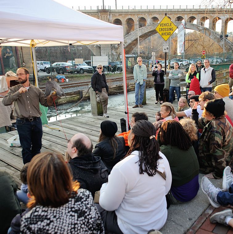
Section 2:
                                                                                                                                                 written in coordination with the 2008 North Camden Neighborhood Plan, informed by ten years of community
                                                                                                                                                 engagement, planning and implementation that can serve as a model of an inclusionary planning process for

 Case Studies of Inclusionary Trail Planning
                                                                                                                                                 other cities. The Waterfront Park will also be a part of the Cross Camden County Trail.

                                                                                                                                                 In the early 1990s, community partners joined the City of Camden to write the original North Camden Plan. Save
 This section highlights successful inclusionary planning practices and discuss areas for growth in case studies                                 Our Waterfront (SOW) was created in 1992 to represent the individuals who live, work, and worship in North
 from Camden NJ, Philadelphia PA, and Washington DC. Planning is only one component to creating an acces-                                        Camden and to coordinate the neighborhood plan. Shortly after, the Delaware River Port Authority (DRPA)
 sible public space, and should be coupled with initiatives that continue beyond the planning phase of the trail                                 released a Riverfront State Prison Site Reuse Study, which reimagined North Camden’s waterfront based on the
 or park. To provide this context, the end of the section describes examples of successful programming in parks                                  premise that the prison would be closing. The study opened a conversation about the waterfront’s potential,
 and trails in the same geographic regions as the case studies.                                                                                  and about reconnecting the river to the core neighborhood.

  Camden, New Jersey                                                                                                                             With renewed interest in the waterfront, in 2008, SOW embarked on updating the original neighborhood plan
                                                                                                                                                 while also creating the North Camden Waterfront Park Plan. These reports were closely coordinated to create
                                                                                                                                                 a long-range vision for North Camden as well as an implementation strategy for community revitalization that
 Cooper’s Poynt Waterfront Park
                                                                                                                                                 benefits North Camden’s social, economic and environmental health.

 Non-profits lead community effort to bring a planned waterfront park to life                                                                    The seven-month community planning process for the North Camden Neighborhood Plan set an important
                                                                                                                                                 precedent and laid the groundwork for the Cooper’s Poynt planning exercises. Cooper’s Ferry Partnership
 Like many other post-industrial cities, Camden New Jersey is turning around after decades of decline, and                                       hired Interface Studio to support the process because of their approach to planning as a form of advocacy
 one of the driving forces is waterfront redevelopment. The waterfront is home to multiple tourist attractions                                   that promotes engaged and equitable communities. CFP, SOW and Interface Studio also worked directly with
 including the Adventure Aquarium and BB&T Pavilion. The city is also home to Rutgers University Camden, as                                      the Planning Steering Committee comprised of city agencies, local partners and North Camden community
 well as Cooper Medical School and two other hospitals. In 2017 the population of Camden was 74,532, with                                        members on the following outreach and engagement initiatives:
 35.6% of families and 38.4% of individuals are below the federal poverty line. The vacancy rate was 18.3%1,
 and the universities and hospitals combined made up 45% of Camden’s total employment2. The most common                                                       1. Confidential one-on-one interviews with residents, community activists, service providers, and
 foreign language spoken in the city is Spanish followed by Vietnamese.                                                                                          neighborhood leaders;
                                                                                                                                                              2. A series of focus groups with representatives from distinct stakeholder groups in the neigh-
 With declining industry, a high concentration of poverty, and a high crime rate, Camden has struggled over the                                                  borhood, including: the Planning Steering Committee, local teen community activists at
 last 50 years. However, private companies are making major investments in the downtown, and public-private                                                      Hopeworks ‘N Camden, religious leaders in North Camden;
 partnerships are working to revitalize neighborhoods and the waterfront. As these new investments approach,                                                  3. Monthly meetings between the Planning Steering Committee and the Interface Studio team to
 public agencies and local organizations are working to make sure that the city’s changes will benefit its residents                                             keep neighborhood and City representatives informed on the process;
 and reflect the people living in Camden.                                                                                                                     4. Five public meetings to share information on the history of the Neighborhood Plan and gather
                                                                                                                                                                 feedback and ideas from community members. This included a visioning session and multiple
                                                                      In 2017, Cooper’s Poynt Waterfront Park                                                    follow-up meetings to inform recommendations for the plan. At each meeting, SOW provided
                                                                      opened just north of the Ben Franklin                                                      Spanish translation for non-native English speakers;
                                                                      Bridge in Camden. The park includes a                                                   5. A Neighborhood Needs Survey in both English and Spanish to gather information on local
                                                                      .4-mile, multi-use trail that is in the Circuit                                            issues, concerns, and future priorities. The surveys were distributed at public meetings, at local
                                                                      Trails Network, with views of the bridge                                                   schools, and through local organizations;
                                                                      and the Philadelphia skyline, an ADA                                                    6. A bi-lingual video installation on the east wall of Salon Parroquial summarizing the planning
                                                                      accessible playground and green space for                                                  process and inviting people to join the implementation effort.
                                                                      the community to enjoy. This park is one
                                                                      piece of the North Camden Waterfront                                       Throughout this process it became clear that although much has changed over the last 15 years in Camden, the
                                                                      Park Plan, which identifies opportunities                                  following core principles of the 1993 North Camden Plan still prove relevant to the community3:
                                                                      for creating a continuous, linear water-
                                                                      front park stretching from the Benjamin                                                   •    No displacement – The people of North Camden who have been in North Camden during its
                                                                      Franklin Bridge to the Cooper River. The                                                       toughest times must be able to stay and enjoy the better times that lie ahead.
                                                                      plan was spearheaded by Cooper’s Ferry                                                    •    Community control – North Camden invites interested investors, developers, public agencies,
                                                                      Partnership (CFP), a private, nonprofit                                                        and private entities to recognize local community leaders and community members as partners.
                                                                      corporation based in Camden, New Jersey                                                   •    Employ local residents – Doing business in North Camden requires local hiring practices.
 Source: NJ Pen                                                       with a mission to facilitate the revival of                                               •    Increase homeownership – Homeownership will deepen residents’ roots in the neighborhood
 the City of Camden as a place where people choose to live, work, visit, and invest. The Waterfront Park Plan was                                                    and, we hope, deepen their commitment to effecting positive change at home and in the
                                                                                                                                                                     neighborhood4.
 1. U.S. Census Data Retrieved from https://www.census.gov/quickfacts/fact/table/camdencitynewjersey/PST045217

 2. Cam Connect. “The Camden Higher Education and Healthcare Task Force: A Winning Investment for the City of Camden,” Rutgers University–Cam-   3. Cooper’s Ferry Development Association, Wallace Roberts & Todd, LLC S.T. Hudson Engineers. “North Camden Neighborhood Plan” 2008
 den, 2012.                                                                                                                                      4. Ibid

8 Inclusionary Trail Planning Tool Kit | Pennsylvania Environmental Council                                                                                                                               Inclusionary Trail Planning Tool Kit | Pennsylvania Environmental Council 9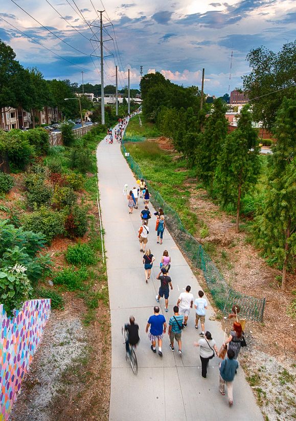
These were the same guiding principles that shaped the Waterfront Park Plan. Working closely with SOW,               at the southeastern county line connecting urban, suburban and rural communities with one another6. Camden
  CFP engaged Camden Greenways, Camden County Parks, Camden City, and the same group of stakeholders                   County and its trail planning consultant team, led by NV5 Inc., completed a feasibility study that explains the
  involved in the neighborhood planning process to identify key themes for the conceptual design of the future         alignment of the trail. To determine the alignment, the team conducted an extensive public outreach campaign
  waterfront park.                                                                                                     to educate the public and gain feedback from the different areas that the cross county trail would pass through.
                                                                                                                       A stakeholder team consisting of municipal partners, county officials, and local non-profits assisted county and
  Working through the goals outlined by the community in the Neighborhood Plan, CFP and SOW implemented                consultant staff with recommendations for the trail location7.
  a planning process acknowledging the many facets of Camden, including housing, transportation, public safety
  and community organizing approaches that can build local capacity and strengthen partnerships throughout the         Through public meetings, online surveys, and mapping exercises, stakeholders determined where citizens want
  city. By planning the waterfront park as a part of a larger system, and not as an isolated space, CFP and SOW        to go on the future trail and what types of amenities the trail needs. Cooper’s Ferry Partnership supported
  inclusively brought a diversity of voices to the table.                                                              outreach in Camden City and through the County, using its community connections with neighborhood groups,
                                                                                                                       nearby businesses and sports leagues. The outreach approach including engaging community members outside
  SOW and CFP worked with consultant Wallace Roberts & Todd (WRT) to engage the community in compre-                   of scheduled meetings, including tabling at the County’s ice skating rink on weekends during the winter months8.
  hensive planning exercises over a five-month period. Community planning began in 2010 with a participatory
  design workshop for residents and stakeholders5. After the workshop, three additional community meetings             The County is continuing to work with communities as they draw from the feasibility study and conceptual plan
  informed a development framework and several illustrative renderings for the former prison site. Several hundred     to develop detailed trail designs.
  community members and numerous organizations, institutions, and city agencies were actively involved in the
  development of the plan.                                                                                             Best Practices from Camden:
  The Cooper’s Poynt Master Plan builds upon the ideas of access and reconnection that are laid out in the Water-
                                                                                                                       •    Building upon an existing community-led planning process
  front Park Plan. The plan calls for the following, all of which were identified as priorities by the community:
                                                                                                                       •    Guiding principles of the plan were developed by the community stakeholders
            •     An extension of the existing east/west                                                               •    Systems approach considers housing, transportation and public safety
                  street grid and the development of two                                                               •    Bilingual survey and outreach materials
                  new north/south streets to the west of                                                               •    Ongoing programming of space
                  Delaware Ave.                                                                                        •    Conducting outreach in a well-visited community space
             •    A public riverfront park accessible from                                                             •    One-on-one interviews
                  new riverfront streets                                                                               •    Focus groups
             •    A linear park lining an extended State                                                               •    Monthly meetings with Planning Steering Committee
                  Street, connecting the riverfront to the
                  existing community
             •    Mid-to-high rise mixed-use development
                  fronting the waterfront park, decreasing                                                              Philadelphia, Pennsylvania
                  in height and density closer to the
                  existing neighborhood east of Delaware                                                               Mantua Greenway
                  Ave.
                                                                                                                       Resilient community leverages nonprofit partnerships to create a greenway
  Two years later, CPWP was built in the City of Camden,
  drawing upon community members’ advocacy efforts                                                                     plan that includes housing and workforce concerns heard in focus groups
  and place-based vision. Since its opening, consistent                                          Source: Google Maps
                                                                                                                       Neighborhood Context and History of Community Planning in Mantua
  programming has kept the community involved and excited about the waterfront space. Family movie nights,
  fitness programs and festivals attract community residents, and programs like I Bike, I Walk, & I Paddle Camden      Mantua is a neighborhood in West Philadelphia located north of Spring Garden Street and south of Mantua
  encourage active transportation and recreation.                                                                      Avenue, between 31st and 40th streets. The neighborhood has a history of community activism dating back to
                                                                                                                       the 1960s when groups like the Young Great Society and the Mantua Community Planners formed in response
  Cross Camden County Trail                                                                                            to an increase in gang violence. At the time, the neighborhood had one of the highest crime rates in the city.
                                                                                                                       These groups held weekly community functions and worked with local police to keep young residents of the
                                                                                                                       area out of trouble9.
  County engages local partners in community engagement for regional trail
                                                                                                                       These groups also worked tirelessly with the city to build the neighborhood’s first community center, which
  The successful processes surrounding the Neighborhood, Waterfront and Cooper’s Poynt Plans have also helped          took over a decade to complete. The multipurpose Mantua-Haverford Community Center is now located at
  inform the ongoing plans for the Cross Camden County Trail, particularly the segment on the Camden water-
  front. This 33 mile trail is projected to span the length of the county, starting at the Delaware River and ending   6. Camden County Division of Environmental Affairs, “Cross Camden County Trail Feasibility Plan” 2017

                                                                                                                       7. Ibid

                                                                                                                       8. Valeria Galarza Phone Conversation, July 9 2018
  5. See Appendix A for resources on participatory design workshops
                                                                                                                       9. Kitchen & Associates. “We are Mantua! Mantua Transformation Plan” 2013

10 Inclusionary Trail Planning Tool Kit | Pennsylvania Environmental Council                                                                                                       Inclusionary Trail Planning Tool Kit | Pennsylvania Environmental Council 11
the corner of 34th Street and Haverford Avenue, and includes the Mantua library branch, a gymnasium, a             The Mantua Greenway
  community office, and a meeting room. The community center plays a vital role in Mantua’s civic life with a
  combination of after-school programs, recreation activities, classes and health awareness programs10.              Through focus groups co-led by community residents, LISC helped formulate seven key neighborhood prior-
                                                                                                                     ities in the Mantua Transformation Plan:
  This strong history of civic engagement is captured in the Mantua Community Planners motto “Plan Or Be
  Planned For.” With this outlook, the community has embraced the opportunity to be involved in planning the                    •    Improve Capacity for Civic Engagement
  future of Mantua. In the Mantua Transformation Plan, community leaders and residents partnered with local                     •    Ensure Quality Education for Mantua’s Youth
  institutions and city agencies on a comprehensive planning process that will guide the neighborhood’s future                  •    Promote Economic Self-Sufficiency
  development and ensure a better quality of life for current and future residents alike.                                       •    Enhance Community Safety
                                                                                                                                •    Promote a Healthier Lifestyle
  The Mantua Transformation Plan provides a summary of key strategies for the revitalization of Mt Vernon Manor                 •    Revitalize Mantua’s Physical Environment
  Apartments and the surrounding neighborhood. The plan is the product of a community-driven planning effort,                   •    Expand Housing Opportunities for All Income Levels
  entitled “We Are Mantua!” (WAM!), organized by the Mt Vernon Manor Board of Directors and its partners
  under HUD’s Choice Neighborhoods Initiative (CNI). Mantua was one of the first communities selected to                                                                                          During the focus groups, community
  receive a CNI Planning Grant, providing a unique opportunity to engage in a comprehensive planning process                                                                                      members lamented the state of Mantua
  structured around three key goals11:                                                                                                                                                            Avenue as an unsafe environment charac-
                                                                                                                                                                                                  terized by abandonment and distress.
    HOUSING: Improve the living environment at Mt Vernon Manor Apartments.                                                                                                                        Participants discussed how the walkway
    PEOPLE: Expand opportunities for an improved quality of life for individuals in the community and their                                                                                       improvements made in the 2000s between
    families.                                                                                                                                                                                     31st and 34th streets were an important
                                                                                                                                                                                                  start, but insufficient to make Mantua
    NEIGHBORHOOD: Make it a viable and well-functioning community, with good housing opportunities,                                                                                               Avenue a desirable place to walk. Through
    access to services, high-quality learning institutions and access to jobs.                                                                                                                    these conversations, the Mantua Avenue
                                                                                                                                                                                                  Revitalization Initiative began, focusing on
  The Mantua Transformation Plan is not the first community driven plan for the neighborhood. The plan has its                                                                                    a comprehensive set of improvements to
  roots in the original Plan for Mantua that was formed in the early 1970s under the auspices of another HUD                                                                                      enhance and expand the existing greenway
  initiative, the Neighborhood Development Program. Through the Mantua Joint Workshop, Mantua leaders and                                                                                         along Mantua Avenue through the redevel-
  local organizations partnered with the Philadelphia Redevelopment Authority and the Philadelphia Housing and                                                                                    opment of vacant properties. The project
  Community Development Agency to address housing, economic development, physical development, health,                                                                                            aims to use public and private land for both
  education and social issues. The resulting Plan for Mantua guided public investments in the neighborhood and                                                                                    new housing and active recreation. With
  shaped Mantua’s community centers, playgrounds and recreation spaces. The development plan and funding                                                                                          these improvements, residents and project
  for the Mt Vernon Manor Apartments was also a part of this effort12.                                                                                                                            partners envision Mantua Avenue as the
                                                                                                                     Mantua Greenway Resident Advisory Committee January 2016 Meeting
                                                                                                                     Source: Mt Vernon Manor CDC                                                  “neighborhood’s front yard14.”
  Over 40 years later that same community planning spirit and ethos was reignited through WAM! to form the
  Mantua Transformation Plan. Residents, local stakeholders, City agencies and partners such as Drexel University,   The Mantua Greenway supports the neighborhood’s priority of promoting healthier lifestyles, and will include a
  Local Initiatives Support Corporation (LISC), Philadelphia Housing Authority (PHA) and the Pennsylvania Horti-     mile-long tree lined bike and pedestrian path, outdoor fitness amenities and artistic murals. LISC is also working
  cultural Society worked together to identify short and long-term solutions required to address the community’s     with local partners to keep the space activated after construction through exercise programs. The maintenance
  most critical needs. An important aspect of WAM!’s success was its effort to make immediate community-driven       plan for the trail is through a partnership with the Philadelphia Water Department, which includes a mandate to
  changes in the neighborhood during the planning process through short-term projects and initiatives.               hire people from the Mantua neighborhood and train them to maintain the space15.
  These early action steps were achievable in scope with minimum or existing resources and helped maintain           While the plan to revitalize Mantua Avenue came from the over 200 residents who took part in the planning
  community interest through long-term neighborhood interventions. An important outcome of the planning              process, LISC also enlisted the National Parks Service for technical support as well as landscape architecture
  process was also building community capacity beyond the scope of this project. During the planning process         students from Philadelphia University to create renderings pro bono16. Improvements will prioritize the segment
  multiple community groups were formed, such as the Mantua Youth Advisory Committee, the Mantua Civic               between 34th and 38th streets, and on a second phase, extend through to 40th street. LISC raised $750,000 from
  Association, and the Community, Home and School Association. These groups collaborated with project                the William Penn Foundation through July 2018 to support the creation of a Friends of the Mantua Greenway
  partners such as LISC and Drexel University to win grants for community projects like summer youth programs,       group, help Mount Vernon Manor complete and implement the Greenway Maintenance Plan, implement Early
  neighborhood clean-up days, and job training opportunities. They were even able to keep the local elementary       Action projects, and fundraise for construction.
  school, Morton McMichael School, open and designated as a Promise Academy which will ensure additional
  funding and resources for the students into the future13.                                                          The Philadelphia City Planning Commission is currently managing the design consultant as well as the early
  10. Mantua History Retrieved from https://theblackbottom.wordpress.com/communities/mantua/history/                 action projects, which include a gateway installation at the corner of 34th Street and Mantua Avenue; a landscape
  11. Kitchen & Associates. “We are Mantua! Mantua Transformation Plan” 2013                                         14. Ibid
  12. Kitchen & Associates. “We are Mantua! Mantua Transformation Plan” 2013                                         15. David Ferris Phone Conversation, July 19, 2018
  13. Ibid                                                                                                           16. David Ferris Phone Conversation, July 19, 2018

12 Inclusionary Trail Planning Tool Kit | Pennsylvania Environmental Council                                                                                              Inclusionary Trail Planning Tool Kit | Pennsylvania Environmental Council 13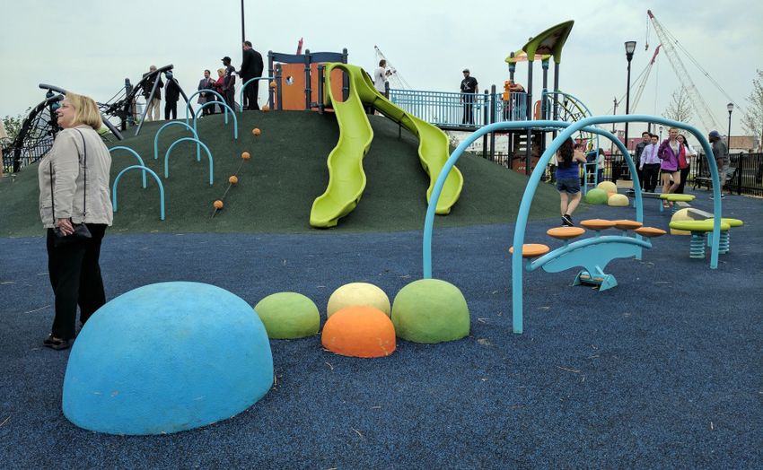
maintenance program that will hire and train Mantua residents; and a creative effort that will engage residents PEC’s community planning process was characterized by their willingness and ability to listen to individual
in creating artistic panels for the fence bordering the Mantua Greenway. residents and community leaders in one-on-one meetings and community outreach events. At the first public
meeting in October 2009, there was pushback from community members concerned about crime, fast moving
Best Practices from We Are Mantua!: traffic, and the loss of parking21. In these meetings, PEC also learned that the overarching major goals of the
community were to improve physical health and street safety in the neighborhood. PEC earned these residents’
support by addressing their concerns in the design and programming of the trail. They revised the design to
• Built upon an existing community planning process
accommodate more parking, add quality pedestrian lighting, include traffic calming measures such as bulb-outs
• Focus groups co-lead by community leaders and program the trail with fitness events.
• Short-term community-driven initiatives that create immediate change with
minimum or existing resources At the second outreach event, only a month later, the project had the support of local pastors, community
• Planning for housing in conjunction with recreation along the Mantua Greenway leaders, educators, and non-profits. These included Bartram’s Garden, CityLights Foundation, Southwest CDC,
• Hiring people from the community to maintain the space Cornerstone Christian Academy, Presbyterian Homes, Ezekiel Baptist Church, Richard Allen Charter School,
Francis Myers Recreation Center and others. The design inspired by the community is a combination of off
and on-road route that includes street crossings with signals to improve pedestrian safety, and maintains some
58th Street Greenway parking. By listening to and immediately addressing community members’ concerns , PEC built trust and support
for the 58th Street Greenway22.
Nonprofit works with local community to acheive trail goals while addressing In addition to incorporating feedback into the design itself, PEC also partnered with the Francis Myers Recre-
safety and beautification concerns heard at community meetings ation Center to create the “Get Active 58th!” healthy living program aimed at making exercise on 58th Street a
regular pastime. To promote a more active lifestyle the program ran every weekend over the course of two
With its southernmost point bordering Bartram’s Garden on the Schuylkill River, 58th Street begins in Southwest summers before the trail was constructed and included activities such as yoga, zumba dancing, runs, rides and
Philadelphia’s Kingsessing neighborhood. This is a vibrant community that is predominantly Black, with a large even a 5k race. Additionally, Neighborhood Bike Works ran classes for kids to learn how to fix (and earn) bikes23.
West African immigrant population that significantly increased since the beginning of the 21st century17. The
neighborhood has several important community institutions such as the Coalition of African Communities The 58th Street Greenway opened in June 2013 with
(AFRICOM), African Cultural Alliance of North America (ACANA), Bartram’s Garden, Southwest Community a community block party, kids bike ride and ribbon
Development Corporation (SWCDC) and the Myers Rec Center. About 30% of the approximately 65,000 cutting at the Francis Myers Recreation Center. Many of
residents in Southwest Philadelphia lives under the poverty line18. the community partners attended, enjoying the food,
music, exercise classes and raffle. The event celebrated
Cobbs Creek Park, home to the 3.7 mile long Cobbs Creek Trail is located in Southwest Philadelphia. However, the City’s investment in Southwest Philadelphia’s future,
it is disconnected from other city trails that would connect to Bartram’s Garden and beyond. In 2009, the and the first for many street designs in the city such
Pennsylvania Environmental Council (PEC) embarked on the 58th Street Greenway project to connect Cobbs as greenback sharrow markings, a sidewalk level cycle-
Creek Trail with the rest of the city, adding 1.5 miles to both the Circuit Trails network and the East Coast track and a shared ped- and bike-crosswalk traffic signal
Greenway. Filling this gap in the trail network is an important precursor to the connection from the Bartram’s actuator24.
Mile trail to Schuylkill River Trail (SRT) coming soon, which will allow people in Southwest Philadelphia to access
many more miles of trails. However, since its opening five years ago the trail has
unfortunately been underused and neglected. One
In addition to bridging an important gap in the trail network, PEC worked with community partners to ensure
important difference between this planning process
that the new trail reflects the community’s goals for their neighborhood. The project began as part of a feasi-
and that of Camden or Mantua is that the idea for the
bility study exploring how to extend the SRT south to the Philadelphia Airport and Heinz National Wildlife
greenway did not come directly from the community,
Refuge19. However, a walking and biking path on 58th Street proved to be the best near-term option as it
but was decided upon by PEC and other partners
connects to an existing trail and provides alternative and active transportation to low income people living
outside of the community. The community planning
in a densely populated neighborhood with few options for outdoor recreation. Considering that it had been
process started once the decision was made to build a
decades since the City invested in street improvements in this neighborhood, PEC knew that robust community Neighborhood Bike Works participants are first to ride on the trail through Southwest Philadelphia, and many of the
outreach and engagement would be necessary to build trust and a successful trail20. PEC's community outreach Greenway at the ribbon cutting. Source: PEC conversations were sparked by distrust and skepticism
process revealed the community's deep concerns about gentrification and displacement. Ultimately the design
about the project. While this top-down approach does not naturally foster community ownership over the trail,
was a low-impact change to the street by creating a multi-use path next to the road, which also functions as a
it is very common for the location of new trail projects to be predetermined. Community ownership may not
sidewalk. This illustrates the "Just Green Enough" approach: a facility that enhances connectivity within the trail
always be possible in these cases, and other measures can be considered to keep the space activated such as
system and provides safe active transportation routes within the community, but is not a driver of real estate
speculation and development. 21. Spencer Fitch, re: “58th Street Greenway Materials” e-mail to Julia Raskin, August 11, 2018
17. Herold, Benjamin. “Student ‘ambassadors’ tackle divide between Africans, African Americans.” Northern hemisphere Fall 2008. Vol. 16, No. 1.1. 22. Fisher, Christine. “58th Street Greenway officially open, connects Cobbs Creek and Bartram’s Garden” Plan Philly 2013 Retrieved from:
http://planphilly.com/articles/2013/06/10/58th-street-greenway-officially-open-connects-cobbs-creek-and-bartram-s-garden
18. U.S. Census Retrieved from: https://factfinder.census.gov/faces/nav/jsf/pages/community_facts.xhtml?src=bkmk
23. Ibid
19. Spencer Fitch, re: “58th Street Greenway Materials” e-mail to Julia Raskin, August 11, 2018
24. Ibid
20. Ibid
14 Inclusionary Trail Planning Tool Kit | Pennsylvania Environmental Council Inclusionary Trail Planning Tool Kit | Pennsylvania Environmental Council 15You can also read