INDIANA ARCHAEOLOGY VOLUME 16 NUMBER 1 - INDIANA DEPARTMENT OF NATURAL RESOURCES DIVISION OF HISTORIC PRESERVATION AND ARCHAEOLOGY (DHPA) 2023 ...
←
→
Page content transcription
If your browser does not render page correctly, please read the page content below
INDIANA
           ARCHAEOLOGY
                       VOLUME 16
                       NUMBER 1
                         2023

        INDIANA DEPARTMENT OF NATURAL RESOURCES
DIVISION OF HISTORIC PRESERVATION AND ARCHAEOLOGY (DHPA)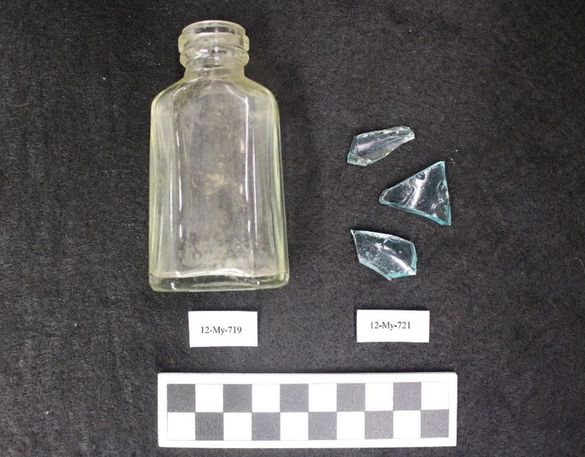
ACKNOWLEDGMENTS
Indiana Department of Natural Resources
Daniel W. Bortner, Director and State Historic Preservation Officer

Division of Historic Preservation and Archaeology (DHPA)
Beth K. McCord, Director and Deputy State Historic Preservation Officer

DHPA Archaeology Staff
Amy L. Johnson, State Archaeologist, Archaeology Outreach Coordinator and
Team Leader for Archaeology
Cathy L. Draeger-Williams, Archaeologist
Wade T. Tharp, Archaeologist
Melody K. Pope, Archaeologist

Editor: Amy L. Johnson

Co-editor: Rachel A. (Lockhart) Sharkey

Editorial assistance: Beth K. McCord

Additional acknowledgments: The editor wishes to thank the authors, as well as all of those who participated in, and
contributed to, the archaeological projects which are highlighted. The U.S. Department of the Interior, National Park
Service is gratefully acknowledged for their support of Indiana archaeological research as well as this volume.

Cover design: The images which are featured on the cover are from the articles included in this journal.

This project has been funded in part by a grant from the U.S. Department of the Interior, National Park Service’s Historic
Preservation Fund administered by the Indiana Department of Natural Resources, Division of Historic Preservation and
Archaeology. The project received federal financial assistance for the identification, protection, and/or rehabilitation of historic
properties and cultural resources in the State of Indiana. However, the contents and opinions contained in this publication do not
necessarily reflect the views or policies of the U.S. Department of the Interior, nor does the mention of trade names or commercial
products constitute endorsement or recommendation by the U.S. Department of the Interior. Under Title VI of the Civil Rights Act
of 1964 and Section 504 of the Rehabilitation Act of 1973, the U.S. Department of the Interior prohibits discrimination on the basis
of race, color, national origin, or disability in its federally assisted programs. If you believe that you have been discriminated
against in any program, activity, or facility as described above, or if you desire further information, please write to: Office of Equal
Opportunity, National Park Service, 1849 C Street, NW, MS-2740, Washington, D.C. 20240.

Mission statement: The Division of Historic Preservation and Archaeology promotes the conservation of Indiana’s
cultural resources through public education efforts, financial incentives including several grant and tax credit
programs, and the administration of state and federally mandated legislation.

For further information contact:

Division of Historic Preservation and Archaeology
402 W. Washington Street, Room W274
Indianapolis, IN 46204-2739
Phone: 317/232-1646
Email: dhpa@dnr.IN.gov
on.IN.gov/dhpa
facebook.com/INdhpa

2023 © Copyright Indiana Department of Natural Resources. Permission must be obtained from the IDNR and the
DHPA for reproduction.

INDIANA ARCHAEOLOGY 16(1) 2023                                     1

Volume 16 Number 1
TABLE OF CONTENTS

Note: The projects discussed, noted below with “HPF,” received federal financial assistance from the Historic
Preservation Fund Program for the identification, protection, and/or rehabilitation of historic properties and cultural
resources in the State of Indiana.

Authors, and not the Department of Natural Resources nor the Division of Historic Preservation & Archaeology
(DHPA), are responsible for ensuring that proper permission is obtained for the use of any images, figures, and
photographs in their articles, as well as ensuring that there are no copyright violations. In addition, the authors are
responsible for providing accurate and proper citations, references, and attributions/credit for any relevant images,
figures, and photographs used in their articles.

This is a refereed, open access journal. All articles and reports/features are reviewed by the editor, the DHPA director,
and two professional archaeologists not with the DHPA. The HPF submissions included in this volume were also
reviewed by co-editor Rachel Sharkey in her capacity as the HPF archaeology grant liaison.

INTRODUCTION .....................................................................................................................................................         3

EDITOR, CO-EDITOR, AND EDITORIAL ASSISTANCE ...................................................................................                                            4

AUTHORS ................................................................................................................................................................   5

ARTICLES
Archaeological Investigations of Fulton County, Indiana: Summary Results
for a FY17 Historic Preservation Fund Survey .........................................................................................................                     6
Matthew P. Purtill, Cecilia M. Szmutko, Hannah Ryker, Carson Wright, Kevin C. Nolan,
and Christine Thompson
(HPF)

An Archaeological Investigation of the Calvert and Porter Woods Nature Preserve,
Montgomery County, Indiana ................................................................................................................................... 26
Kelli Wathen, Christine Thompson, and Kevin C. Nolan
(HPF)

FEATURE
Hoosier Archaeology Insights interview with Dr. William L. Mangold .................................................................. 45

GLOSSARY OF TERMS ......................................................................................................................................... 55

PRECONTACT INDIANS OF INDIANA ............................................................................................................... 59

INDIANA ARCHAEOLOGY 16(1) 2023                                                        2
INTRODUCTION
          Per state statute (Indiana Code 14-21-1-12), one of the duties of the DHPA is to develop a program of
archaeological research and development, including the publication of information regarding archaeological resources
in the state. This journal is one of the ways that our office continues to address that mandate. Also, Indiana Code 14-
21-1-13 states that the Division may conduct a program of education in archaeology. Indiana’s cultural resources
management plans have also listed educating the public about Indiana’s Native American cultures and identifying,
and studying Native American, African American, and other ethnic and cultural heritage resources, as ways to
accomplish several preservation goals. The variety of archaeological sites in Indiana, and what has been learned about
the sites, is wide-ranging and impressive.
          For those who may not be familiar with some archaeological terms, a helpful glossary of some of these
general terms is included in the back of this journal. To also aid the lay reader, a general overview of precontact time
periods may be found at the end of this volume. Additional archaeological outreach documents, including Early
Peoples of Indiana and previous volumes of Indiana Archaeology, may be accessed at on.IN.gov/archaeo-pubs.

    • The authors are thanked for their submissions.
    • Our colleagues who contributed peer reviews for this volume are also thanked.
    • Former DHPA coworker Rachel Sharkey is thanked for her work as co-editor of this volume.
    • I would also like to express my appreciation to Dr. William L. Mangold for the opportunity to interview him as
     part of our “Hoosier Archaeology Insights” initiative. Bill has been a friend and valued colleague for many years.

This volume of Indiana Archaeology is in memory of Catharine A. Carson. Cathy was a former DHPA coworker who
passed away unexpectedly in September, and she will be truly missed by her archaeology friends and colleagues.

                                                                                                                —ALJ

INDIANA ARCHAEOLOGY 16(1) 2023                             3
EDITOR, CO-EDITOR, AND EDITORIAL ASSISTANCE

Editor

Johnson, Amy L.– Ms. Johnson, State Archaeologist, Archaeology Outreach Coordinator, and Team
Leader for Archaeology, has worked for the DHPA since 1991. She is also Indiana’s state network
coordinator for the Public Education Committee of the Society for American Archaeology. Ms. Johnson
holds a B.S. and a M.A., both Anthropology, from Ball State University. Her main research interests
are precontact archaeology (specifically the Adena and Hopewell periods), historic cemeteries, and
public outreach regarding archaeological resources.

Co-Editor

Sharkey, Rachel A. (Lockhart)– Ms. Sharkey was with DHPA from 2011 to 2022. She is now the
Director of Public Archaeology at the Archaeological Research Institute in Lawrenceburg, Indiana. She
received her B.S. in Archaeology and Anthropology and her M.S. in Human Biology from the
University of Indianapolis. Her previous research focused on bioarchaeology, but she has since
branched out to having an interest in a broad range of topics in archaeology, including schoolhouses,
historic bottles, and native plants.

Editorial assistance

McCord, Beth– Ms. McCord, Director of the Indiana Division of Historic Preservation & Archaeology
and Deputy State Historic Preservation Officer, has worked in cultural and heritage management for
more than 25 years. She received her M.A. in Anthropology from Ball State University. During her
career, she has worked with clients in the government, engineering, transportation and energy sectors.
McCord has also worked on several state and federal grant projects, authored published articles and
technical reports, and presented her research to a variety of audiences.

INDIANA ARCHAEOLOGY 16(1) 2023                           4
AUTHORS
Nolan, Kevin C., Ph.D.– Dr. Nolan is the Director and Senior Archaeologist of the Applied Anthropology
Laboratories, an Institute in the College of Sciences and Humanities at Ball State University. He has a Ph.D. in
Anthropology from Ohio State University and a M.A. from Kent State University. Kevin’s current interests
include working with private collectors, distributional archaeology, Hopewell societies, late precontact
societies, and archaeology of the Northwest Indian Wars.

Purtill, Matthew P., Ph.D.– Dr. Purtill is Assistant Professor in the Department of Geology at the State
University of New York at Fredonia. He has a Ph.D. in Physical Geography from West Virginia University, an
M.A. in Physical Geography from University of Cincinnati, and a M.A. in Anthropology from the University
of Cincinnati. Matthew’s current interests include aeolian geochronology and depositional systems notably as
they relate to the potential for archaeological site burial.

Ryker, Hannah– Hannah Ryker is the Project Archaeologist at the Applied Anthropology Laboratories at Ball
State University. She received her B.A. in Anthropology from Indiana University and her M.A. in Anthropology
from Indiana University-Purdue University Indianapolis (IUPUI). Her research interests include historical
archaeology and the use of archival resources to interpret archaeological data.

Szmutko, Cecilia M.– Ms. Szmutko obtained her master’s degree in Anthropology from Ball State University
(BSU) in 2021 and received her B.A. in Anthropology from University of Southern Indiana in 2014. She served
as a Graduate Assistant with the Applied Anthropology Laboratories at BSU between 2017 and 2019. Her
primary research interest includes Late Precontact period archaeology, specifically the relationship between Fort
Ancient and Mississippian cultures. She has participated in numerous unique and challenging archaeological
projects over the span of her ten-year archaeological career and has had the opportunity to conduct fieldwork in
13 states. Ms. Szmutko is currently working with her local county park district to develop a public outreach
program to educate children about archaeology, and she works full-time as a staff archaeologist with Kleinfelder,
Inc.

Thompson, Christine– Ms. Thompson studied at Miami University, has a bachelor’s and MBA from Indiana
Wesleyan University, and after a 25-year career in business, earned her M.A. in Anthropology from Ball State
University. She is the Assistant Director and Archaeologist at the Applied Anthropology Laboratories (AAL),
Ball State University and has been with the AAL since 2009. Her major research interests are the Late Archaic
Glacial Kame, historic battlefield archaeology, and public archaeology and education.

Wathen, Kelli– Kelli Wathen received her M.A. in Anthropology from Ball State University in 2019 with a
focus in bioarchaeology and her B.A. in archaeology from the University of Evansville in 2015. During graduate
school she worked as a Research Assistant in the Department of Anthropology's Applied Anthropology
Laboratory (AAL). She is currently an Associate Archaeologist and GIS Analyst at Applied EarthWorks in San
Luis Obispo, California. Her research areas of interest include spatial analysis and emerging technologies in
archaeology.

Wright, Carson– Carson Wright is a graduate assistant with the Applied Anthropology Laboratories and a Ph.D.
student in the Environmental Science program at Ball State University. He has a M.S. in Natural Resources and
Environmental Management from Ball State University. Carson’s research interests include sustainable
agricultural practices and soil fertility.

INDIANA ARCHAEOLOGY 16(1) 2023                            5
ARCHAEOLOGICAL INVESTIGATIONS OF FULTON COUNTY, INDIANA:
SUMMARY RESULTS FOR A FY17 HISTORIC PRESERVATION FUND
SURVEY

MATTHEW P. PURTILL1, CECILIA M. SZMUTKO2, HANNAH RYKER3, CARSON WRIGHT4, KEVIN C.
NOLAN5, AND CHRISTINE THOMPSON6
1
    DEPARTMENT OF GEOLOGY AND ENVIRONMENTAL SCIENCES, SUNY FREDONIA, NY
2
    KLEINFELDER, INC.
3-6
    APPLIED ANTHROPOLOGY LABORATORIES, BALL STATE UNIVERSITY, MUNCIE, IN

[NOTE- At the time this article was written, all authors were with Ball State University.]

ABSTRACT
          The Applied Anthropology Laboratories (AAL) at Ball State University conducted a data enhancement
project for archaeological resources in Fulton County, Indiana, for a FY2017 Historic Preservation Fund (HPF) Grant
(#18-17FFY-04). This HPF Grant project included the investigation of the archaeological resources of Fulton County,
with a focus on four south-central townships (Henry, Liberty, Union, and Wayne) and General Land Office (GLO)
sites in Rochester Township. A total of 924 acres (373.93 hectares) of agricultural land was surveyed, including 4.36
acres (1.76 hectares) of resurveyed area. The survey recovered 94 precontact and 1,806 historic artifacts from 11
survey areas within Fulton County. Artifacts were grouped into 108 new archaeological sites including 43 sites with
precontact components (including one Early Archaic, one Late Archaic, and two Late Woodland/Late Precontact), 57
sites with historic components, and eight sites with both precontact and historic components. The average site density
recorded for the survey areas for precontact sites was one site per 18.11 acres and for historic sites was one site per
14.22 acres. Sites were found on till plains, moraines, outwash plains, and lake plains. Local Silurian chert types were
the most common precontact tool stone found during the survey, with four diagnostic projectile points discovered.

INTRODUCTION
          The AAL was awarded a FY2017 HPF Grant to survey portions of Fulton County, Indiana. The project
started with a background research of soils, soil associations, landforms, and chert. A pedestrian survey of 11 survey
areas comprised 924 acres of agricultural land in 11 survey areas, including 4.36 acres of resurveyed area. This article
addresses several of the main goals of the grant including increasing the number of sites known for the county, refining
the cultural chronology for the county, examining evidence for early Euro-American settlement, exploring potential
Potawatomi settlements, and investigating multiple GLO sites (General Land Office 1795-1840). Fulton County had
58 archaeological sites recorded in the State Historic Architectural and Archaeological Research Database (SHAARD)
prior to the start of this survey (Division of Historic Preservation and Archaeology [DHPA] 2007). This investigation
focused on four south-central townships (Henry, Liberty, Union and Wayne) and GLO sites in Rochester Township.
In documenting new sites in Fulton County, we also hoped to eventually increase our understanding of the Euro-
American presence and American Indian utilization in northern Indiana by comparing the results to recently concluded
HPF Grant surveys for neighboring counties such as Benton (FY2015, Grant #18-15FFY-03; FY2016, Grant # 18-16-
FFY-03) (Balough et al. 2016, 2017), Jasper (FY2014, Grant #18-14-FFY-02) (Macleod et al. 2015), and Newton
(FY2014, Grant #18-14-FFY-03; FY2015, Grant #18-15-FFY-05; FY2016, Grant #18-16-FFY-04) (Clark et al. 2017;
Leeuwrik et al. 2015, 2016).

BACKGROUND
         AAL conducted a review of the natural and cultural settings to provide a framework for interpreting the data
collected during this project. The background information presented in this article includes basic environmental and
archaeological information concerning Fulton County.

INDIANA ARCHAEOLOGY 16(1) 2023                             6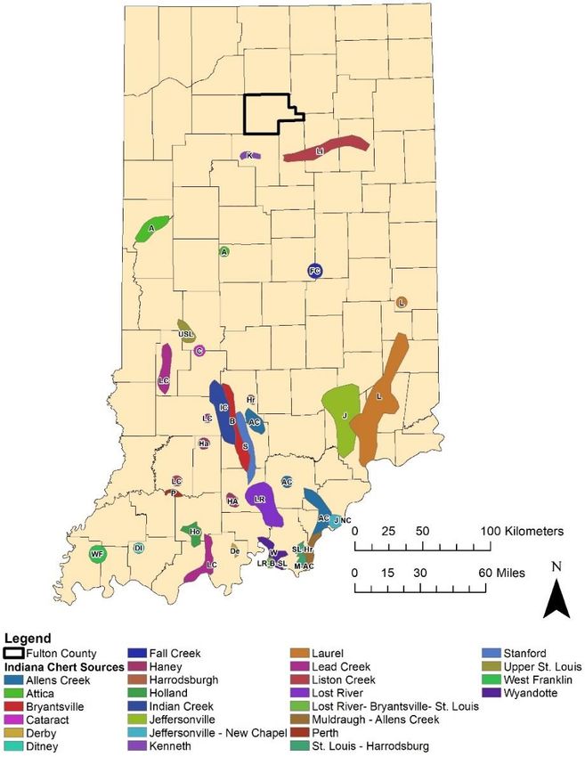
NATURAL SETTING
          Fulton County (outlined in black in Figure 1) consists of 237,709 acres (Furr 1987:1) of glaciated landscape.
Gray (2000) and Gray and Sowder (2002) map the northern portion of Fulton County within the Plymouth Morainal
Complex Section of the Northern Moraine and Lake Region, whereas the southern portion of the county, including all
11 survey areas, is mapped as the Warsaw Moraines and Drainageways Section of the Northern Moraine and Lake
Region.
          Topographic relief of Fulton County ranges from generally level to strongly sloping. Both the southern and
northeastern portions of the county consist of level to slightly undulating till plains with natural drainageways, while
the southeast part of the county is more clay rich in subsoil with abrupt relief, and the north-central part of the county
is a gravelly morainal area with rolling topography (Furr 1987:2). Topography has been heavily influenced by scouring
and retreat of the Wisconsin glaciation (Gray 2000:1). Attica, Liston Creek, Kenneth are the documented regional
bedrock cherts that outcrop to the south of Fulton County (Figure 1).
          The county is primarily drained by the Tippecanoe River drainage, which includes many small lakes and
swamps situated along its meanders. The tributaries of the Tippecanoe River drain these small lakes and swamps and
have a rather consistent discharge throughout the year (Lindsey et al. 1961:107). Poorly drained soils, combined with
the low-lying topography, contributed to the formation of the many small kettle lakes and other wetlands that cover
much of the county (e.g., Furr 1987). Such conditions are similar across most of northern Indiana.

Figure 1. Chert outcrop locations in Indiana (digitized by Brad Painter from Cantin 2008).

INDIANA ARCHAEOLOGY 16(1) 2023                              7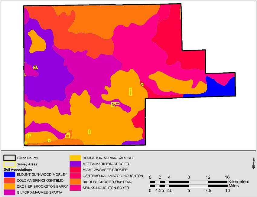
Soils and Landforms
          The majority of the soils found in Fulton County have formed in either glacial or fluvial parent material.
Glacial till sediments typically have clayey to silty textures and contain angular particles of sand and gravel. Textures
of glaciofluvial, or outwash, deposits range from silty to gravelly depending on the water source that carried them.
The more recent fluvial deposits found on flood plains and river terraces are dominated by loamy textures.
          The FY2017 HPF survey areas show variability in their soil associations (Table 1; Figure 2). Soil associations
represent groups of geographically related soil types that are similar to one another in various aspects including texture,
setting, and parent material. For this research, soil associations were used as a proxy for landforms (e.g., till plains,
moraines, stream terraces, etc.) since associations typically occur in a regular geographic pattern upon the landscape
(Table 1).

Table 1. Soil Associations and Landforms Associated with Survey Areas (USDA/NRCS 2015a).
       Soil Association                         Landform(s)                   Survey Areas
 Riddles-Crosier-Oshtemo       Till Plains, Moraines, and Outwash Plains           1, 3, 6
 Crosier-Brookston-Barry       Till Plains and Moraines                      2, 3,4, 6, 8, 9, 11
 Metea-Markton-Crosier         Till Plains and Moraines                                5
 Miami-Wawasee-Crosier         Till Plains and Moraines                               10
 Gilford-Maumee-Sparta         Outwash Plains, Till Plains, and Lake Plains          7, 8

Figure 2. Soil associations in Fulton County (based on terminology in STATSGO, USDA/NRCS 2002). See Table 1
for associated landforms for each soil association.

INDIANA ARCHAEOLOGY 16(1) 2023                              8
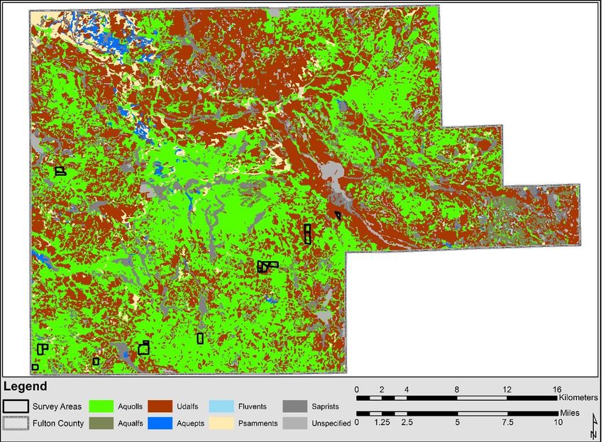
Within Fulton County, soils are mapped as one of six Soil Orders and seven Suborders (USDA/NRCS 2015a)
(Figure 3). The most common orders are Alfisols (42.92%) and Mollisols (41.66%). Mollisols are thick, organic-rich
soils that are naturally fertile and common throughout in prairie or savannah-like regions (USDA/NRCS 2015b:381).
Aquolls are wet (a.k.a. Aquic) Mollisols exhibiting a seasonally high water table (USDA/NRCS 2015b:391). Aquolls
often have been artificially drained and converted to agriculture (USDA/NRCS 2015b:420). Alfisols support, or once
supported, forest environments and consist of two Suborders (Udalfs and Aqualfs) in the 11 survey areas. Udalfs
represent the typical Alfisol. Aqualfs are Alfisols with at least seasonally wet conditions (USDA/NRCS 2015b). The
vegetation supported previously would have been tall grass prairies and occasionally a deciduous forest (USDA/NRCS
2015b:420).

Figure 3. Soil suborders located within Fulton County (USDA/NRCS 2015a).

CULTURAL SETTING
          In Fulton County, archaeological site components indicate that American Indians inhabited the region from
the Paleoindian period through the Historic period. Given the previously described environmental background, we
expected variable artifact densities over space due to the interrupted distribution of habitable areas interspersed with
wetlands (see also Surface-Evans 2015) and a variable distribution through time as precipitation and ground moisture
levels fluctuated during the Late Pleistocene and Holocene periods. Of the previously documented sites with
documented periods of occupation, Historic period components (n=33) are the most frequent followed by Protohistoric
period (n=5), Early Archaic (n=3), Paleoindian (n=1), Early Woodland (n=1), and Late Woodland/Late Precontact
(n=1) components (DHPA 2007). The majority of the other Precontact components are listed as unknown or are simply
classified to a broader period such as “Unknown Woodland.”

INDIANA ARCHAEOLOGY 16(1) 2023                             9
Although SHAARD contains only a single Paleoindian site for the county, Dorwin (1966:Figure 1) and
Tankersley et al. (1990) identified additional fluted points (see also Shott 2004:208; White et al. 2007). Previous to
our survey, three Early Archaic sites (12FU47, 12FU50, and 12FU51) had been documented in Fulton County (DHPA
2007). Point types recovered from Early Archaic sites include one Kirk Stemmed and a Thebes/St. Charles (DHPA
2007; Stillwell 1997). Site 12FU51 reportedly has multiple components including Paleoindian, Early Archaic, Early
Woodland, and Late Woodland/Late Precontact (DHPA 2007; White et al. 2007). There is one site (12FU28) in Fulton
County labeled as containing a general Woodland component that includes a report of an earthen burial mound (DHPA
2007). The possible mound was originally recorded by GLO surveyor Austin W. Morris in 1834 (DHPA 2007).
Prior to survey, there were five sites (12FU12, 12FU16, 12FU23, 12FU29, and 12FU37) assigned to a
Protohistoric period (as “unknown Native American”) for Fulton County (DHPA 2007). These sites, which included
burials, camps, and a cemetery, were recorded in the GLO survey notes (General Land Office 1795-1840). Later,
Maust and Cochran (1989) defined and recorded these sites in SHAARD based on the GLO records.
Guernsey’s map (1933) shows multiple Potawatomi villages in what is now Fulton County, including the
large Aubbeenaubee Reserve, home of Potawatomi Chief Aubbeenaubee, in northern Fulton County. Also noted are
Toisa’s and Masac’s villages along the Tippecanoe River, and Kewanna and Wimego’s villages in southern Fulton
County. Two of the previously mentioned GLO sites (burials 12FU16 and 12FU29) were associated with Toisa’s and
Masac’s villages (DHPA 2007). Lake Manitou in central Fulton County is noted on Guernsey (1933) as Maneto in
Potawatomi. The lake was created by damming in 1827 to provide water for a grist mill (Potawatomi Mills)
constructed by the United States government as part of a treaty agreement with the Potawatomi. A blacksmith shop,
trading post and a house were also constructed in the area of the lake and the mill (Guernsey 1933; Lake Manitou
Association 2022).
In the early 1800s, American Indians inhabiting Indiana began to cede their land rights to the U.S.
government, and were moved, often forcefully, to reservations within the state or to the west. The Treaty of
Mississinewa (1826) ceded Potawatomi and Miami land in northeast Indiana, including eastern Fulton County. Also
in 1826, the Potawatomi ceded a strip of land from Indianapolis to Lake Michigan to create the Michigan Road, which
went through central Fulton County. The Treaty of Tippecanoe (1832), ceded Potawatomi land in northwest Indiana,
including western Fulton County (Fay 1971; Forest County Potawatomi 2022; Kappler 1972). Forced removal of
American Indians from Indiana was largely complete by 1838 as local tribes such as the Potawatomi were moved to
Kansas. This federal action, historically known as the Potawatomi Trail of Death, was responsible for the forced
movement of 859 Potawatomi people. In total, the Potawatomi Trail of Death spanned 660 miles and extended from
Twin Lakes, Indiana, to Osawatomie, Kansas. The removal took approximately two months and resulted in the death
of over 40 individuals, mostly children (Citizen Potawatomi Nation Cultural Heritage Center 2022; Hamilton 1996;
Thorpe 2003). The removal trail crossed Fulton County from north to south through Rochester, and near several of
this project’s survey areas.
The first Euro-American settlers were present in Fulton County as early as 1831 (Henning 1987:xiii). In
1836, Fulton County was officially organized after previously being a part of Cass County to the south, and the city
of Rochester was chosen as the county seat. Initially, the county consisted of three large Townships: Liberty, Richland,
and Rochester, with five more, Aubbeenaubbee (named after the Potawatomi Chief and part of Reserve land), Henry,
Newcastle, Union, and Wayne, added forming the current county boundaries (Henning 1987:xiii). Settlement of the
county was slow between 1840 and 1876, but the building of the Indianapolis, Rochester, Chicago Railroad in 1868
spurred significant population growth by the end of the nineteenth century (Henning 1987:xiii).
ARCHAEOLOGICAL SURVEY METHODS AND RESULTS
METHODS
Field Survey
For this grant project, survey areas were selected using topographic maps, aerial maps, soil information,
historic sources, and reconnaissance information. The survey was constructed to sample different regions within
Fulton County, with an emphasis on previously unsurveyed agricultural land in the southern and central portions of
Fulton County, and cultivated fields with optimal visibility. Ultimately, landowner permission and field visibility
dictated the areas sampled by this survey which included 924 acres of moraines, outwash, lake plains, and till plains.
AAL archaeologists and student field technicians conducted this project with Christine Thompson and Kevin
C. Nolan serving as Principal Investigators. The field survey was conducted between August 26 and November 26,
2017 and consisted of pedestrian transects spaced at 10-meter intervals. The survey interval was reduced to five meters
when artifacts were encountered. The areas surveyed by pedestrian transects had between 30 and 90% ground surface
visibility. All artifacts within two meters of the first artifact encountered were collected and mapped as a single find
location. However, fire-cracked rock and brick were merely field counted. All collected artifacts were bagged and
INDIANA ARCHAEOLOGY 16(1) 2023 10given temporary transect and find numbers. Artifacts at farther distances within the same transect were assigned the
same transect number and the next sequence number. If a site consisted of only a single collection point, a 10 x 10
meter radial survey area was investigated around the find spot, 5 meters in each direction. Each new radial find was
assigned a new find number. If multiple artifacts were encountered along multiple transects, short transects were
traversed at five-meter intervals to refine the boundaries of the cluster. Find points were mapped with a Trimble
GeoXT Series GPS with a minimum of 20 readings logged for each find spot. GPS data is imported from the Trimble
to the GPS Pathfinder Office series 5.3 software for post-processing including Differential Correction. The coordinate
system was set for UTM NAD83 Zone 16N. Sites were defined with 15-meter buffers created around mapped artifact
locations. The 15-meter buffers were used to define artifact clusters that constitute a ‘site.’ Site boundaries were
defined by five meter buffers around each site cluster. These boundaries were used to compile site attributes such as
area, soil type, and site density. Site density was calculated by dividing the number of acres (924 acres) within a survey
area by the number of sites (108 archaeological sites) located within that survey area.
Laboratory
All collected artifacts were processed at the AAL laboratory according to standard procedures (see Szmutko
et al. 2018:Appendix B, Appendix C). Lithic raw materials were identified by comparison with reference samples and
published descriptions on file at AAL (Cantin 2008; DeRegnaucourt and Georgiady 1998) and reported by geologic
period, noting which “type” is most consistent with the specimen. All chert identifications were made microscopically
at 10x magnification or greater. Historic artifacts were classified according to various published and online sources
(ACH Food Companies Inc. 2014; Adams 2002; American Chemical Society 2016; Bower 2009; Briscoe Center for
American History 2012; Brown 1982; Brown and Lebo 1991; Classic Bells Ltd. 2017; Dovetail Cultural Resource
Group 2017; Feldhues 1995; Godden 1964; Horn 2005; Intermountain Antiquities Computer System [IMACS] 1992,
2009; Lindsey 2017; Lockhart et al. 2008, 2013; Lockhart and Hoenig 2015; Maples 1998; Maryland Archaeological
Conservation Laboratory 2010, 2015, 2016a, b, c; Mayer 1994; Miller 2000; Miller et al. 2000; Ohio Department of
Transportation [ODOT] 1991; Peterson 2007; Schrader-Bridgeport International 2017; Stelle 2001; Tinkham 2002;
Tod 1977; Wiggins 2017; William Reed Business Media Ltd 2017). Notes, maps and photographs were reviewed and
prepared for illustration and curation. Project materials and artifacts not requested to be returned to the landowners
are curated at the AAL under accession number 16.115. State site numbers were obtained and a Division of Historic
Preservation and Archaeology (DHPA) Sites and Structures Inventory form was entered in SHAARD for each site
identified during the project.
RESULTS
As part of the FY2017 HPF survey, AAL surveyed 924 acres in Fulton County. This survey identified 108
new archaeological sites representing 119 cultural components within the 11 survey areas. Of the 108 archaeological
sites identified, 43 have precontact cultural components, 57 have historic cultural components, and eight have
precontact and historic cultural components. Of sites with precontact components, 50 are classified as Unidentified
Precontact. Dated precontact cultural components include one Early Archaic site, one Late Archaic site, and two Late
Woodland/Late Precontact sites. Sixty-five sites have historic components primarily representing assemblages that
date from the nineteenth through early twentieth centuries.
Artifacts
A total of 94 precontact and 1,806 historic artifacts were recovered by the survey (Table 2). The majority of
precontact artifacts are lithic debitage, with 10 showing indications of edge modification including retouching and
use-wear. Recent use-wear analyses of similar tools in Indiana, indicate that many, if not most, debitage were used in
processing meat, hide, bone, and occasionally plant resources (see Swihart 2016). Of the five formal lithic tools, four
were diagnostic (Figure 4) and include one corner-notched St. Charles Dovetail projectile point dating to the Early
Archaic period (Justice 1987:57), one Brewerton Side Notched projectile point dating to the Late Archaic period
(Justice 1987:115), and two Madison projectile points dating to the Late Woodland/Late Precontact period (Justice
1987:224). Other stone tools include a complete non-diagnostic biface, and utilized and retouched flake tools. Historic
artifacts included various types of ceramics, glass, metal objects, and brick fragments.
INDIANA ARCHAEOLOGY 16(1) 2023 11Table 2. FY2017 HPF Grant Artifacts Identified During Survey.
Precontact No. Historic No.
Biface, Hafted, Brewerton Side Notched 1 Ceramic, Ironstone 50
Biface, Hafted, St. Charles Dovetail, Beveled, 1 Ceramic, Kaolin 1
Corner-Notched
Biface, Unhafted, Madison Triangular 1 Ceramic, Pearlware 5
Biface, Unhafted, Madison Triangular, Incomplete 1 Ceramic, Porcelain 39
Biface, Unhafted 1 Ceramic, Redware 23
Flake, Complete 14 Ceramic, Whiteware 262
Flake, Complete, Heat Treated 1 Ceramic, Stoneware 293
Flake, Complete, Heat Damaged 1 Ceramic, Yellowware 9
Flake, Complete, Biface Thinning 3 Glass, Amber 109
Flake, Complete, Retouched 2 Glass, Amethyst 74
Flake, Complete, Retouched, Heat Treated 1 Glass, Aqua 357
Flake, Complete, Use Wear 1 Glass, Clear 416
Flake, Distal 9 Glass, Cobalt 7
Flake, Distal, Retouched 1 Glass, Depression 2
Flake, Distal, Heat Treated 1 Glass, Green 14
Flake, Distal, Retouched, Heat Damage 1 Glass, Milk 47
Flake, Distal, Use Wear 2 Glass, Olive 1
Flake, Medial 3 Glass, Red 3
Flake, Medial, Heat Damage 1 Metal, Aluminum 4
Flake, Proximal 5 Metal, Brass 2
Flake, Proximal, Heat Treated 3 Metal, Bronze 1
Flake, Proximal, Modified Edges 1 Metal, Copper 2
Flake, Tool 1 Metal, Iron, Cut Nail 12
Flake, Tool, Retouched 1 Metal, Iron, Wire Nail 5
Angular Shatter 19 Metal, Iron, Wire 1
Angular Shatter, Heat Damage 1 Metal, Iron/Tin 1
Angular Shatter, Heat Treated 3 Metal, Iron, Miscellaneous 39
Angular Shatter, Retouched 2 Metal, Tin/Aluminum 1
Core 8 Metal, Steel, Valve Part 1
Ground stone, Tool, Hammerstone 2 Faunal, Cortical, Long Bone 2
Ground stone, Tool, Expedient 1 Faunal, Cortical, Bone 3
Granite, FCR 1 Faunal, Unidentified Bone 2
Faunal, Shell 2
Other, Coal 5
Other, Charcoal 1
Other, Graphite Battery 2
Other, Brick (collected) 8
Other, Brick (not collected) 520
Total 94 Total 2,326
INDIANA ARCHAEOLOGY 16(1) 2023 12Figure 4. Diagnostic precontact artifacts recovered during survey including a corner-notched St. Charles Dovetail
point (site 12FU115), Brewerton Side Notched point (site 12FU68), and two Madison points (sites 12FU112 and
12FU66).
Chert
While no natural chert outcrops exist within Fulton County, all nearby outcrops are Silurian in age (Figure
1). Owing in part to their local and semi-local occurrence, the lithic artifacts recovered by this survey were
predominantly made of Silurian cherts (63.8%) (Table 3). One non-diagnostic biface recovered from site 12FU76 was
made with Liston Creek chert. A Late Woodland/Late Precontact Madison point (from site 12FU112) was consistent
with Laurel chert. Mississippian chert had the second greatest representation of identified cherts in this survey (6.4%),
with Devonian and Pennsylvanian cherts the next most represented cherts in abundance (5.3% each). A Late Archaic
Brewerton Side Notched point (from site 12FU68) was made of chert consistent with Jeffersonville. An Early Archaic
corner-notched St. Charles Dovetail point (from site 12FU115) was made of chert consistent with Holland Dark Phase.
A Late Woodland/Late Precontact Madison point (from site 12FU66) was made with chert consistent with Holland.
The breakdown of the chert types (Table 3) is slightly skewed by the large percentage of unknown chert in the total
assemblage (14.9%), and even within geologic periods (1.1% of Mississippian cherts were unidentified).
Table 3. Chert Types and Relative Frequencies Encountered During Survey.
% of
Age Chert Qty County(s) with nearest outcrop
assemblage
Silurian 60 63.83
Kenneth 9 9.57 Cass
Laurel 6 6.38 Wayne
Liston Creek 41 43.63 Huntington, Miami, Wabash
Fall Creek/ Liston 1 1.06 Madison, Hamilton, Huntington, Miami,
Wabash
Liston Creek/ Kenneth 1 1.06 Huntington, Miami, Wabash, Cass
Liston Creek/ Laurel 2 2.13 Huntington, Miami, Wabash, Wayne
Mississippian 6 6.38
Attica/ Sugar Creek 2 2.13 Boone, Warren
Indian Creek 2 2.13 Owen
INDIANA ARCHAEOLOGY 16(1) 2023 13Wyandotte 1 1.06 Crawford, Harrison
Unidentified 1 1.06
Devonian 5 5.32
Jeffersonville 5 5.32 Bartholomew, Decatur, Jefferson,
Jennings
Pennsylvanian 5 5.32
Holland 4 4.26 Dubois, Spencer
Holland Dark Phase 1 1.06 Dubois, Spencer
Unidentified 14 14.89
Chert
Granite 4 4.26
Total 94 100%
The identified chert breakdown suggests that precontact people living in Fulton County relied on close
Silurian-age chert sources (e.g., Liston Creek and Kenneth) for tool stone. Just over half (55.6%) of the chipped-stone
assemblage was made of these nearby sources. Local sources are followed closely by a reliance on more exotic chert
types from southern Indiana (Laurel and Jeffersonville to the southeast, and Holland and Holland Dark Phase to the
southwest of Fulton County), which make up 17.8% of the total lithic assemblage. All identifiable points (n=4) were
manufactured of non-local cherts, including Laurel, Holland, Holland Dark Phase, and Jeffersonville cherts. The
exclusive presence of these materials in the diagnostic tool assemblage may indicate that precontact American Indians
in Fulton County had some level of connection to southern Indiana, either through trade, direct procurement, or
perhaps even migration.
Archaeological Components
Of the 119 newly identified archaeological components from 108 newly identified sites, 50 are classified as
Unidentified Precontact. Identified precontact components consist of two Archaic (Early and Late Archaic) and two
Late Woodland/Late Precontact. Sixty-five sites have historic components, all of which represent mid-nineteenth
through early twentieth century assemblages. Most historic sites appear to reflect activities associated with the
operating of rural residences or farmsteads. As seen in Table 4, the results of the FY2017 HPF survey essentially
doubled the number of archaeological components previously known for Fulton County.
Table 4. Number of Site Components Added to SHAARD.
Cultural Period Previous Added Total
Unidentified Precontact 7 50 57
Paleoindian (ca. 10,000 – 7500 BC) 1 0 1
Archaic 5 2 7
Early Archaic (ca. 8000 – 6000 BC) 3 1 4
Middle Archaic (ca. 6000 – 3500 BC) 0 0 0
Late Archaic (ca. 4000 – 700 BC) 0 1 1
Unidentified Archaic 2 0 2
Woodland 4 2 6
Early Woodland (ca. 1000 – 200 BC) 1 0 1
Middle Woodland (ca. 200 BC – AD 600) 0 0 0
Late Woodland/Late Precontact (ca. AD 500 – 1650) 2 2 4
Unidentified Woodland 1 0 1
Protohistoric/Contact 5 0 5
Historic (post AD 1650) 33 65 98
Unknown 1 0 1
Total 56 119 175
INDIANA ARCHAEOLOGY 16(1) 2023 14Early historic settlement in Fulton County is represented by 65 sites that range from isolated finds to extensive
artifact scatters and occasionally multicomponent sites with precontact and historic artifacts. Historic assemblages
range from small artifact scatters that likely reflect historic dump sites or secondary deposits from relatively recent to
modern activity. At least three large assemblages of historic artifacts were recovered from Survey Areas (SA) 1 and
SA 6 at sites 12FU65, 12FU67, and 12FU126. Additional large historic scatters were identified in SA 3 (site 12FU98)
and SA 7 (site 12FU139). Many of these large assemblages display a diverse array of artifact types that are indicative
of primary deposits and locations of structures or activity areas. Based on dateable materials, these historic sites appear
to represent nineteenth through early twentieth century occupations, primarily rural residences and farmsteads.
Density
The FY2017 HPF Grant investigations of Fulton County documented an average of one precontact or historic
site per 8.55 acres and an average artifact density of one artifact per 0.49 acres surveyed. The project documented an
average density of one historic artifact per 0.51 acres surveyed and an average density of one precontact artifact per
9.82 acres surveyed. Artifact densities by survey area are presented in Table 5. SA 7 had the highest density of sites
per acre (0.19), while SA 3 had the lowest (0.02). SA 6 demonstrated the highest number of artifacts per acre (5.79),
while SA 10 had the lowest (0.04). Overall, the highest densities of artifacts were observed in survey areas associated
with moraines, outwash plains, and till plains (SA 2, 3, 4, 5, 6, and 9) and the lowest density was observed in survey
areas associated with moraines and till plains (SA 10), which were underrepresented in the survey. This is in contrast
to the high proportion of artifacts found on moraine landforms in previous HPF investigations in Benton County
(Balough et al. 2016:Table 37; 2017:Table 43) and comparable to the percentage of sites found on lake and outwash
plains in Newton County (Clark et al. 2017:Table 32).
Table 5. FY2017 HPF Artifact Densities.
Sites/ Artifacts/
Survey Area Acres Sites Artifacts
Acre Acre
SA 1 (Moraines and Till Plains) 160.8 29 0.18 644 4.01
SA 2 (Moraines and Till Plains) 78.31 9 0.11 25 0.37
SA 3 (Till plains, Moraines, and Outwash Plains) 47.47 1 0.02 102 2.15
SA 4 (Moraines and Till Plains) 112.2 7 0.06 507 4.52
SA 5 (Till plains, Moraines, and Outwash Plains) 92.32 13 0.14 17 0.18
SA 6 (Moraines and Till Plains ) 43.34 8 0.18 251 5.79
SA 7 (Lake Plains, Outwash Plains, and Till Plains) 145.4 28 0.19 254 1.75
SA 8 (Lake and Outwash Plains) 67.93 4 0.06 7 0.1
SA 9 (Moraines and Till Plains) 59.53 4 0.07 83 1.39
SA 10 (Moraines and Till Plains) 26.83 1 0.04 1 0.04
SA 11 (Moraines and Till Plains) 89.95 4 0.04 9 0.1
Total 924 108 0.12 1900 2.06
DISCUSSION
CULTURAL CHRONOLOGY
Prior to this 2017 survey, Fulton County had seven Unidentified Precontact sites, one Paleoindian site, five
Archaic sites, three Woodland sites, five Protohistoric sites, and 33 Historic sites documented in SHAARD (see Table
4). This survey added an additional 108 sites (119 cultural components) including 50 Unidentified Precontact site
components, one Early Archaic site component, one Late Archaic site component, two Late Woodland/Late Precontact
site components, and 65 Historic site components. In addition, three projectile point types (two previously unrecorded)
were added to the knowledge of Fulton County’s prehistory. The previously unrecorded point types were one Early
Archaic corner-notched St. Charles Dovetail point, and one Late Archaic Brewerton Side Notched point. Additionally,
two Late Woodland/Late Precontact Madison triangular points were added to the county’s inventory.
The lack of diagnostic artifacts for Fulton County makes assessment of cultural chronology difficult. Archaic
and Woodland cultural periods are minimally represented in SHAARD. Diagnostic projectile points recovered from
the FY2017 HPF survey have improved the deficiency of knowledge regarding the Late Archaic and Late
INDIANA ARCHAEOLOGY 16(1) 2023 15Woodland/Late Precontact periods to a degree. Limited information continues to impede our understanding of the
Paleoindian, Middle Archaic, Middle Woodland, and Protohistoric periods in Fulton County. It is important to note
that the current distribution of dateable components for Fulton County still may not accurately represent occupation
patterns as professional archaeological surveys have been rare in the county. Professional archaeological surveys,
especially those associated with Federal permitting, have helped build the cultural chronologies in other counties by
requiring investigations in areas that would not have otherwise been targeted by researchers. Another potential reason
that the cultural phase representations may be skewed for Fulton County is due to sampling bias. Many of the surveys
conducted have been on similar upland landforms rather than a more representative sample of distinct landform types
within the county. Finally, the activity of collectors likely further skews this distribution since few private collections
are added to the SHAARD or professionally documented. Efforts to systematically document these collections could
pay major dividends in understanding regional cultural history (Nolan et al. 2018; Shott 2008; Shott and Nolan 2016;
Shott et al. 2018). These factors illustrate the importance of HPF surveys especially in data deficient areas such as
Fulton County.
LANDFORM DISTRIBUTION AND ECOTONES
Although limited, the results from the 924 acres of the FY2017 HPF survey show Early Archaic, Late
Archaic, and Late Woodland/Late Precontact presence in the county across several landform types (Table 6). The
distribution among landforms may suggest differential use through time. No evidence of the Paleoindian presence was
recovered in this survey. Diagnostic precontact artifacts suggest Early Archaic and Late Woodland/Late Precontact
use of lake, outwash, and till plains. Late Archaic use of till plains also is suggested by this survey.
Table 6. Precontact Dated Sites by Landform and Soil Association.
Landform Soil Association Sites and Cultural Periods
Lake, Outwash, and Till Plains Metea-Markton-Crosier 12FU112 (Late
Woodland/Mississippian),
12FU115 (Early Archaic)
Till Plains Riddles-Crosier- 12FU66 (Late Woodland/Mississippian),
Oshtemo 12FU68 (Late Archaic)
Of the 11 surveyed areas, seven had a precontact component with more than three artifacts. SAs 1, 5, and 7
yielded 79.8% (n=75) of all precontact artifacts recovered from the survey areas. The proximity of precontact sites to
different ecotones (micro-ecologies) is important to consider when evaluating the access to certain natural resources
in the past. More than 60% of Fulton County sites were located on soils typical of prairies, and soils typical of forested
regions. Both prairie (Mollisols) and forested (Alfisols) soils are represented in all 11 survey areas (Figure 3). There
are a few locations where a combination of three or more soil suborders create an ecotone, on the landscape. These
specific environmental settings offered a diversity of resources that were available for exploitation for subsistence and
other aspects of daily life.
EARLY HISTORIC SITES AND SETTLEMENT
One of the seminal events that occurred in Fulton County was the forced removal of resident Potawatomi
populations in 1838 (Citizen Potawatomi Nation Cultural Heritage Center 2022; Hamilton 1996; Thorpe 2003). The
removal of Potawatomi people along the Trail of Death to eastern Kansas allowed previously populated land in
northern Indiana to become open to Euro-American settlement by the mid-nineteenth century. Archaeological
evidence for the Trail of Death, however, was not identified during the FY2017 HPF survey. Although the presence
of the Potawatomi had declined, the vast majority of western expansion into Fulton County did not take place until
the late nineteenth century with the arrival of the railroad to Rochester, Indiana, which connected the towns of
Logansport, Kewanna, and Grass Creek by 1883 (Henning 1987:xiii). By 1902, the Cincinnati, Richmond, Muncie
Railroad was constructed, further increasing availability of land for Euro-American settlement in Fulton County.
In line with the history of the railroads in northern Indiana, archaeological evidence from the FY2017 HPF
grant project demonstrates that Euro-American settlement of Fulton County accelerated by the late nineteenth century.
Most archaeological evidence suggests that these early settlers were focused on farming and likely went about clearing
lands and draining wetlands to improve the agricultural potential of Fulton County. Substantial historic artifact
assemblages were identified at sites 12FU65 (SA 1), 12FU67 (SA 1), 12FU98 (SA 3), 12FU126 (SA 6), and 12FU139
(SA 7) (Table 7). All of these sites represent mid-nineteenth through early twentieth century rural residences or
INDIANA ARCHAEOLOGY 16(1) 2023 16farmsteads. Artifact densities are moderate to high, and assemblages include a range of functional groups from
domestic food storage and serving to architectural debris. Several identified sites did yield artifacts with mid-
nineteenth century manufacturing ranges, such as pearlware and some transfer-print whitewares, possibly suggesting
occupation as early as the mid-nineteenth century. All of these sites, excluding 12FU126, were located in close
proximity to a structure as illustrated on the 1883 historic atlas (Kingman 1975).
Table 7. Survey Areas with Precontact and Historic Artifacts in Fulton County.
Survey Historic Precontact
Area Artifact Qty Artifact Qty
SA 1 595* 49
SA 2 21 4
SA 3 102* 0
SA 4 506 1
SA 5 7 10
SA 6 250 1
SA 7 238 16
SA 8 3 4
SA 9 79 4
SA 10 1 0
SA 11 4 5
All
Survey 1,806 94
Areas
* This count does not include uncollected brick fragments
By 1907, the structures on the 1883 atlas (Kingman 1975) at sites 12FU67 and 12FU98 are no longer
illustrated in atlas maps (Geo. A. Ogle & Co. 1907), suggesting that these farmsteads were abandoned by around the
turn of the twentieth century. The presence of artifacts with twentieth century manufacturing dates may indicate that
related activities or dumping continued in some areas after the site ceased to operate as a residence. Site 12FU139 is
interesting because it has a different structure illustrated in 1907 (Geo. A. Ogle & Co. 1907), compared to 1883
(Kingman 1975), which may indicate construction of a new residence but continuation of the farmstead. Site 12FU126
is anomalous as no cartographic evidence exists to suggest a structure ever stood close to the site boundary, despite
ample artifactual evidence of typical domestic activities. This site may reflect the location of an outbuilding associated
with a nearby farmstead or could simply reflect a nineteenth through early twentieth century dump site.
One of the goals of this survey was to investigate some of the GLO sites first reported in the late eighteenth
and early nineteenth centuries (General Land Office Surveys 1795-1840). Five survey areas (6, 7, 8, 10, and 11)
overlapped or encompassed the approximate boundaries of three GLO sites. GLO site 12FU22 was first reported by
surveyor Sylvester Sibley in 1834 as “Mr. William Martin’s crop” (General Land Office Surveys 1795-1840). The
site was then classified by Maust and Cochran (1989) as a historic agricultural field. Sites 12FU36 and 12FU37 were
first reported by surveyor Austin W. Morris in 1834 as “Old Sugar Camp[s]” (General Land Office Surveys 1795-
1840). Later, Maust and Cochran (1989) classified 12FU36 as a historic sugar camp and site 12FU37 as an unknown
Native American sugar camp.
Although there were a few sites discovered during this survey in the general vicinity of the three GLO sites,
they do not appear to represent the remains of these sites as they were originally reported (General Land Office Surveys
1795-1840). Therefore, this survey provided little archaeological evidence to confirm the location, or integrity, of
these GLO sites. This lack of evidence is likely due to the ephemeral nature of these site types. If evidence of the
agricultural field or sugar camps was present it was likely too subtle to be detected.
CONCLUSIONS AND RECOMMENDATIONS
This project included the investigation of the archaeological resources of Fulton County, Indiana, with a
focus on four south-central townships (Henry, Liberty, Union, and Wayne), and GLO sites in Rochester Township.
The overall project area was selected due to the lack of known archaeological sites in SHAARD and the identification
of Fulton County as a data deficient county. The project goals addressed in this article were increasing the site
database, refining the cultural chronology for the county, examining evidence for early Euro-American settlement,
exploring potential Potawatomi settlements, and investigating multiple GLO sites (General Land Office 1795-1840).
INDIANA ARCHAEOLOGY 16(1) 2023 17Sites discovered by the FY2017 HPF grant investigation vary from isolated finds to dense artifact scatters.
Since few large surveys have been conducted within the county prior to this current survey, it is difficult to compare
these results with past surveys within the county. However, surveys in the surrounding counties of northern Indiana
have demonstrated that variability in land-use patterns, both precontact and historic, occurred and are detectable in
the archaeological record (e.g., Balough et al. 2016, 2017; Clark et al. 2017; Leeuwrik et al. 2015, 2016; Macleod et
al. 2015; Purtill et al. 2021). Based on past results, it is likely that variation in soil associations, and by proxy
landforms, and ecological resources influenced the habitability of the county.
The presence of the Tippecanoe River, its tributaries, and the variety of lakes were likely also a factor of
precontact and historic settlement in the area over time. At Euro-American contact, the county consisted of Oak-
Hickory forest and wetlands with minor amounts of Beech-Maple forest. During precontact periods, wetlands were
economically important and appear to have attracted people for seasonal resources (Surface-Evans 2015). Although
wetland resources were attractive to both precontact and historic groups, variable boundaries of natural wetlands
would have restricted land resources until large-scale efforts to drain wetlands were conducted after Euro-American
settlement. The constraint of wetlands appears to have concentrated population groups on elevated, dry landforms
such as sand dunes, or “sand hills” as they are colloquially called, during precontact and historic periods (e.g., Purtill
et al. 2021; Surface-Evans 2015).
The majority of the precontact components identified during this survey were non-diagnostic, so temporal
interpretations of potential patterns are limited. However, four diagnostic artifacts (Figure 4) were recovered including
an Early Archaic corner-notched St. Charles Dovetail point (Site 12FU115), a Late Archaic Brewerton Side Notched
point (site 12FU68), and two Late Woodland/Late Precontact Madison points (sites 12FU66 and 12FU112) (Justice
1987), adding to the cultural chronology for Fulton County.
Unfortunately, resurvey of areas reported to contain GLO sites (General Land Office Surveys 1795-1840;
Maust and Cochran 1989) in Rochester Township (12FU22, 12FU36, 12FU37) provided little archaeological evidence
to confirm the location, or integrity, of these sites. Several newly discovered sites were identified in the general vicinity
of the reported GLO sites, but they do not appear to represent the remains of these sites as reported in the late
eighteenth through nineteenth centuries. Site 12FU22 was identified as an agricultural field, thus archaeological
evidence may be lacking. Both sites 12FU36 and 12FU37 were reported to be ‘old sugar camps’ that, again, may have
left sparse archaeological evidence. The lack of confirmation during this survey should not be interpreted to mean that
evidence for these GLO sites does not exist, but rather that additional investigation may be needed to detect their
presence. For example, future geophysical or geochemical studies may reveal evidence of intact features or signatures
that would not be represented in the current archaeological record (e.g., Nolan 2014; Roos and Nolan 2012).
By the middle to end of the nineteenth century, following removal of American Indian groups from northern
Indiana, Euro-American settlement in Fulton County increased in magnitude. Much of this increase is in response to
the establishment of railroad networks that would have opened northern Indiana to potential settlement.
Archaeological evidence and historical documentation suggest numerous mid-nineteenth through early-twentieth
century rural residences or farmsteads across the landscape in Fulton County, especially after 1876. The fact that
several structures illustrated on the 1883 atlas were no longer extant on the 1907 atlas also suggests that many of these
early historic sites were short lived and likely subject to family relocation or land consolidation efforts.
As a result of the FY2017 HPF grant survey, six sites (12FU65, 12FU67, 12FU68, 12FU98, 12FU126,
and12FU139) were recommended as potentially eligible for listing on the Indiana Register of Historic Sites and
Structures (IRHSS) and the National Register of Historic Places (NRHP) (Table 8). Four sites contained diagnostic
projectile points including two sites from SA 1 (12FU66 and 12FU68) and two sites from SA 5 (12FU112 and
12FU115). The presence of diagnostics, and reports from local landowners of previously discovered precontact
artifacts, indicates that further research could yield important information about precontact settlement patterns in
Fulton County.
Table 8. Sites Recommended for Inclusion on the NRHP and IRHSS.
Site Cultural Period(s) Site Type(s)
12FU65 Unidentified Precontact, Historic Precontact Isolate, Historic Scatter
12FU67 Unidentified Precontact, Historic Lithic Scatter, Historic Scatter
12FU68 Late Archaic, Unidentified Precontact, Historic Lithic Scatter, Historic Scatter
12FU98 Historic Historic Scatter
12FU126 Historic Historic Scatter
12FU139 Historic Historic Scatter
INDIANA ARCHAEOLOGY 16(1) 2023 18You can also read