Industries and Economic Activity - International Institute for ...
←
→
Page content transcription
If your browser does not render page correctly, please read the page content below
LOWER WINNIPEG RIVER BASIN DISCUSSION SHEET SERIES
Sheet #10

Industries and Economic Activity
                                                                                            May 2021

Introduction
The lower Winnipeg River basin (LWRB) is located in the northwest section of the entire
Winnipeg River basin (WRB), which spans parts of western Ontario and small parts of
Manitoba and northern Minnesota, United States. The Discussion Sheet Series highlights
research on ecological and socio-economic aspects of the basin to encourage discussion with
experts, government departments, Indigenous groups, and stakeholders. The Discussion Sheet
Series is based on available data collected in 2018 and 2019. Sheet 10 of 11 summarizes
industries and economic activities in the LWRB.

Industries
The LWRB supports several active industries, primarily mining and hydroelectric development,
that contribute to the regional economy through job creation, as well as capital and operating
expenditures. They are also sources of government revenue through taxation. The region also has
high levels of interaction with the river and regional lakes through recreational fisheries, tourism,
remote hunting and fishing lodges, boating, and cottagers.

Mining
The LWRB is part of the mineral-rich Precambrian Shield. The primary minerals historically
mined in the region were gold, silver, lithium, nickel, copper, tin, tantalum, and caesium
(Government of Manitoba, n.d.c). While active mining is limited, the region has a considerable
number of inactive mines and history of mineral exploration. There are 19 mine sites located in
the LWRB; almost all of them are non-operational or abandoned (Figure 1).

Only one mine is operational in the LWRB: the Tanco Mine, located 60 km east of the Town
of Lac du Bonnet, produces caesium formate (Martins et al., 2013) (Figure 1). While the
mine’s operations are below its peak capacity (Godkin, 2014), at the peak of operation, the
mine significantly contributed to the regional economy by employing 150 people and spending

© 2021 International Institute for Sustainable Development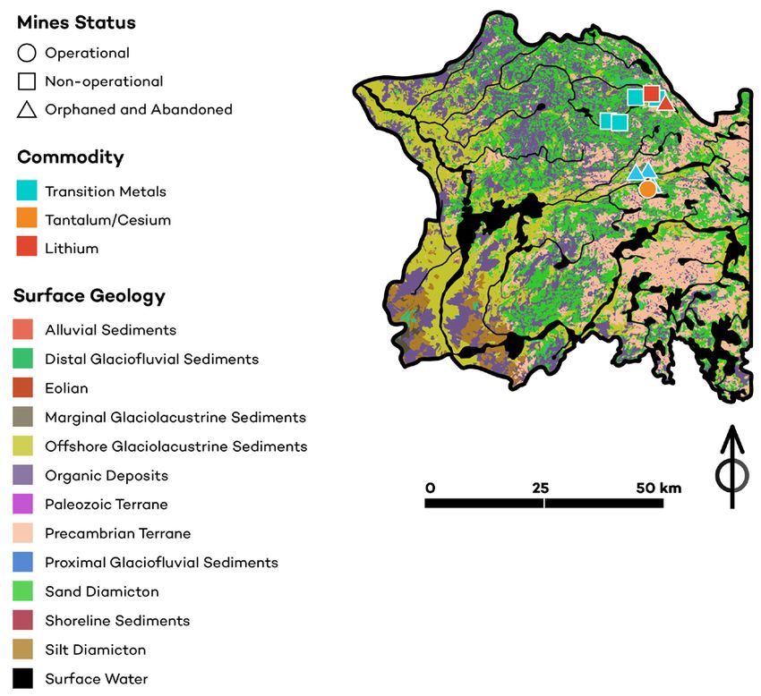
Industries and Economic Activity

approximately CAD 9 million on payroll each year and CAD 28 million in total annual spending
(Government of Manitoba, 2013b). Zienkiewicz (2013) noted that the Tanco mine previously
contributed more than CAD 1.5 million in payroll annually to the economy of the Lac du Bonnet
area alone.

The pegmatite1 that the mine exploits lies beneath Bernic Lake. As such, the mine operations
have the potential to cause environmental damage and adversely impact water quality in the lake
and downstream (Bird River2 and Winnipeg River). According to Martins et al. (2013), efforts
have been made to minimize environmental damage in the area. The plant design enables it to
capture any spilled material and store waste in a lined disposal cell, eliminating discharges into
the lake. The Environmental Impact Assessment states that, even though the mine activities
resulted in a measurable change from the pre-mining condition of Bernic Lake, “the changes that
have occurred are not considered to be adverse” (Government of Manitoba, 2013a, p. 131). The
incidence of algae has increased in the lake but not to the extent that water quality degradation
has occurred (Government of Manitoba, 2013a).

Recent mining explorations took place in the Bird River Greenstone Belt (Grid Metals Corp,
2018) and north of Cat Lake in Nopiming Provincial Park (Wilderness Committee, 2018), which
points to an ongoing commercial interest in these areas.

Forestry
There is currently no operational forestry in the area (Manitoba GeoPortal Open Data, 2018).
Before the shutdown of the Tembec mill in Powerview-Pine Falls in 2009, forestry was a
major source of income for many people in the LWRB (Canadian Press, 2010; Government of
Manitoba, 2013a). The mill’s closure has improved the quality of the environment and people’s
health, but it has resulted in job losses, forcing many people to relocate to seek employment
(Norman, 2018). Forestry operations may resume in the future, as four Indigenous communities
are currently exploring commercial forestry opportunities in the area with the goal of setting up
an Indigenous-led company (CBC News, 2019).

Hydroelectric Generation
There are six run-of-river hydroelectric generating stations on the Winnipeg River supporting
the generation of about 10% of Manitoba Hydro’s electric power and producing around CAD
203 million in revenue for the company in 20183 (Manitoba Hydro, 2018) (Figure 2). Manitoba
Hydro supplies electricity to local commercial facilities and private residences in the basin. In
the Lac Du Bonnet area (including the Winnipeg River System), there were approximately 2,500

1 Pegmatites are rocks that have solidified from lava or magma and are composed almost entirely of crystals, often
sources of valuable minerals (e.g., gem minerals, lithium minerals) (Encyclopaedia Britannica, 2013).
2   Bernic Lake discharges into the Bird River via Bernic Creek (see Sheet 11: Maps).
3   Total revenue (electric) in 2018 was CAD 1,931 million (Manitoba Hydro, 2018).

                                                                                                        IISD.org     2
Industries and Economic Activity
commercial customers and 24,000 residential customers (personal communication, Manitoba
Hydro, October 9, 2018).
Manitoba Hydro is also a large employer. Approximately 133 staff work at Winnipeg River
Operations (Point Du Bois, Slave Falls, Seven Sisters, McArthur, Great Falls, Pine Falls), and
approximately 556 staff work in the larger Eastman area (Dugald, Great Falls, Lac Du Bonnet,
Point Du Bois, Selkirk, Steinbach) (personal communication, Manitoba Hydro, October 9, 2018).
Agriculture
The agricultural industry has been an important component of the region’s economic activity,
particularly in the RM of Lac Du Bonnet and the RM of Alexander. The zoning map (see
Sheet 9: Land Management) shows that a large proportion of the LWRB is designated as Rural
Agricultural. In terms of actual land use, agricultural cropland covers 3% of the LWRB (see
Sheet 2: Landscape Characteristics). According to the 2016 census, 5.8% of the labour force is
employed in “agriculture, forestry, fishing and hunting”4 in the RM of Alexander and 3.6% in the
RM of Lac du Bonnet compared to 4.4% in Manitoba as a whole.
There is agricultural activity in the broader Winnipeg River basin, specifically the RM of
Whitemouth, which can have downstream effects on water quality in the LWRB (see Sheet 4:
Water Quality and Nutrient Loading).
Tourism and Recreation
Tourism is a critically important industry for the LWRB area. The diversity of rivers and lakes
and the location of the Whiteshell Provincial Park make the area a popular destination for
summer cottagers and outdoor recreation. The area provides numerous recreational opportunities,
including fishing, hunting, canoeing, rafting, camping, boating, hiking, cross-country skiing, and
snowmobiling. As discussed in Sheet 7: Demographics and Communities, some regions of the
LWRB comprise a high proportion of seasonal residents (e.g., the RMs of Alexander and Lac du
Bonnet) and have high density related to cottage development.
The LWRB is part of the Eastman Tourism region, which covers the southeast region of the
province between Lake Winnipeg and the Ontario border and stretches as far north as the 53rd
parallel. Travel Manitoba conducted assessments of the economic value of tourism for this region
and found that visitation in the Eastman region accounts for 20% of all Manitoba’s visitors—
or 2,223,000 visitors, who spent CAD 138.4 million in 2015—9% of all tourism spending in
Manitoba (Travel Manitoba, 2016). The LWRB’s potential for recreation and tourism continues
to be developed. The new Provincial Tourism Strategy for Manitoba aims to achieve CAD 2.2
billion in annual spending generated by 12.6 million visitors in 2022 (Travel Manitoba et al.,
2019); this may increase future tourism development in the LWRB.
4 North American Industry Classification System (NAICS).
IISD.org 3Industries and Economic Activity
Fishing
There is no commercial fishing on the Winnipeg River and no fish packing stations in the LWRB.
Recreational fishing, however, is one of the principal leisure activities on the Winnipeg River
and adjacent tributaries and lakes, including an active guided sport fishing industry. Anglers
in the LWRB significantly contribute to the local economy and to the economy of the province,
estimated at CAD 55 million in 2018 based on a survey by Manitoba Water Stewardship (2005).
The successful recreational fisheries are dependent on healthy fish populations and, in turn,
aquatic habitat and water quality in the region (see Sheet 5: Aquatic Animals and Habitat and
Sheet 4: Water Quality and Nutrient Loading). Apart from the economic benefits, the fisheries
provide a range of non-tangible benefits, such as enjoyment from being outdoors.
Economic activities rely on and may impact the watershed and its resources. The
industries discussed here, especially hydroelectric generation, mining, and tourism, are
both locally and regionally important: they create and support jobs, generate incomes,
and are a source of government revenues through taxes. The potential expansion of
economic activity in the LWRB, specifically in the mining, forestry, and tourism sectors,
needs to be reconciled with ecological and social priorities and impacts before any
project moves forward.
IISD.org 4Industries and Economic Activity
Figure 1. Surficial geology and mine site map of the LWRB
Source: Government of Manitoba, n.d.a.
IISD.org 5Industries and Economic Activity
Figure 2. Map of the LWRB, highlighting the generating stations
Communities
1 Fort Alexander / Sagkeeng
2 Powerview-Pine Falls
1 s
Fall
3 Lac du Bonnet Pine
2
4 Pinawa
er
v
Great Falls Ri
rd
Falls Bi
rthur
McA
Generating Station
nipeg R
W in i ve r
River/Stream Lorem ipsum Eaglenest
Lac du Lake
Trans-Canada Highway 3 Bonnet Point du
Bois
Highway Slave Falls
Other Road Seven eg Rive r
W i n nip
Sisters 4 W
Mainline Railroad hi
te
sh
Other Raiload
el
l
W
Water Quality Sites
hit
em
ou
th
R.
0 25 50 km
Canadia n Nation a l
Source: Government of Manitoba, n.d.a. Canadia
n P acifi
c
References
Canadian Press. (2010). Tembec closing Pine Falls mill permanently. Winnipeg Free
Press. https://www.winnipegfreepress.com/local/tembec-closing-pine-falls-mill-
permanently-102134699.html
CBC News. (2019, February 28). Agreement paves way for Indigenous-owned company to manage
forestry, harvest in eastern Manitoba. https://www.cbc.ca/news/canada/manitoba/first-nations-
forestry-east-lake-winnipeg-1.5037974
Encyclopaedia Britannica. (2013). Pegmatite. https://www.britannica.com/print/article/448763
Godkin, D. (2014, August 1). Miner keeps close watch on cesium underground. Canadian
Mining Journal. http://www.canadianminingjournal.com/features/miner-keeps-close-watch-
on-cesium-underground/
Government of Manitoba (n.d.a). Manitoba Land Initiative. http://mli2.gov.mb.ca/
Government of Manitoba. (n.d.b). Map gallery: Mineral dispositions. https://web33.gov.mb.ca/
mapgallery/mgm-md.html
IISD.org 6Industries and Economic Activity
Government of Manitoba. (2013a, September 19). Environmental Impact Assessment and
Mitigation Plan. In TANCO Mine Notice of Alteration #19. https://www.gov.mb.ca/sd/eal/
registries/1906.2tanco/noa_19_chapter_5.pdf
Government of Manitoba. (2013b, August). Notice of Alteration #20 TANCO Mine Crown
Pillar Mitigation Project Description: Executive summary. https://www.gov.mb.ca/sd/eal/
registries/1906.3tanco/noa_20_executive_summary1.pdf
Grid Metals Corp. (2018). Mustang name changes to Grid Metals Corp [New Release]. https://
gridmetalscorp.com/site/assets/files/5073/june8_2018.pdf
Manitoba GeoPortal Open Data. (2018). Manitoba Forest Management Licence Agreement Areas.
https://geoportal.gov.mb.ca/datasets/manitoba-forest-management-licence-agreement-
areas?geometry=-132.092%2C48.841%2C-Geo66.438%2C57.966
Manitoba Hydro. (2018). Transforming your service: Manitoba Hydro-Electric Board 67th annual
report for the year ended March 31, 2018. https://www.hydro.mb.ca/corporate/ar/pdf/annual_
report_2017_18.pdf
Manitoba Water Stewardship. (2005). Angling in Manitoba: 2005 survey of recreational angling.
https://gov.mb.ca/fish-wildlife/pubs/fish_wildlife/05survey.pdf
Martins, T., Kremer, P. and Vanstone, P. (2013). The Tanco mine: Geological setting, internal
zonation and mineralogy of a world-class rare element pegmatite deposit [Field Trip Guidebook
FT-C1/Open File OF2013-8]. Geological Association of Canada–Mineralogical Association
of Canada Joint Annual Meeting. Manitoba Innovation, Energy and Mines, Manitoba
Geological Survey. https://www.gov.mb.ca/iem/info/libmin/gacmac/OF2013-8_FT-C1.pdf
GAC-MAC Winnipeg 2013
Norman, D. (2018, June 22). Opportunities opening up at old mill site. Winnipeg River Advocate,
3(13), 9. https://winnipegriveradvocate.com/wp-content/uploads/2018/06/WRA-JUNE-22-
WEB.pdf
Travel Manitoba. (2016). Growing stronger together in Eastern Manitoba. https://www.
eastmantourism.ca/uploads/2017/Eastern%20Profile%202014%20stats.PDF
Travel Manitoba, Manitoba Chambers of Commerce, & Government of Manitoba. (2019).
Provincial Tourism Strategy. https://assets.simpleviewinc.com/simpleview/image/upload/
v1/clients/manitoba/Provincial_Tourism_Strategy_LR_66e4c2bf-2324-4011-926a-
80d5c0b23ef0.pdf
Wilderness Committee. (2018). Mining destruction discovered in Nopiming Provincial Park.
https://www.wildernesscommittee.org/news/mining-destruction-discovered-nopiming-
provincial-park
Zienkiewicz, M. (2013). Tanco Mine, near Lac du Bonnet, laying off 40% of staff. Winnipeg Sun.
https://winnipegsun.com/2013/03/13/tanco-mine-near-lac-du-bonnet-laying-off-40-of-staff/
wcm/71be24d1-37a9-4192-8bb2-c892d6634e9e
IISD.org 7© 2021 The International Institute for Sustainable Development
Published by the International Institute for Sustainable Development.
This publication is licensed under a Creative Commons Attribution-
NonCommercial-ShareAlike 4.0 International License.
INTERNATIONAL INSTITUTE FOR SUSTAINABLE DEVELOPMENT
The International Institute for Sustainable Development (IISD) is an award-winning
independent think tank working to accelerate solutions for a stable climate, sustainable
resource management, and fair economies. Our work inspires better decisions and sparks
meaningful action to help people and the planet thrive. We shine a light on what can be
achieved when governments, businesses, non-profits, and communities come together.
IISD’s staff of more than 120 people, plus over 150 associates and consultants, come from
across the globe and from many disciplines. Our work affects lives in nearly 100 countries.
IISD is a registered charitable organization in Canada and has 501(c)(3) status in the
United States. IISD receives core operating support from the Province of Manitoba and
project funding from governments inside and outside Canada, United Nations agencies,
foundations, the private sector, and individuals.
Head Office
111 Lombard Avenue, Suite 325 Tel: +1 (204) 958-7700
Winnipeg, Manitoba Website: www.iisd.org
Canada R3B 0T4 Twitter: @IISD_news
iisd.orgYou can also read


