INTRODUCTION TO WATER PROBLEMS IN CANARY ISLANDS
←
→
Page content transcription
If your browser does not render page correctly, please read the page content below
Part 2
                                                                   Water Management and Protection

    INTRODUCTION TO WATER PROBLEMS IN CANARY
                                           ISLANDS

                                      J.C. Santamarta-Cerezal
               Escuela de Ingeniería Civil e Industrial, Universidad de La Laguna, Spain
                                       J. Rodríguez-Martín
                                     Satocan SA, Tenerife, Spain

ABSTRACT: Canary Islands are faced with a unique set of environmental and cultural issues perti-
nent to the management of water resources. Fresh water resources are under threat on many islands
from both overuse and contamination.There is a huge relevance of tourist water use for each island
of the archipelago.Because of a geographic isolation, limited physical resources, unique ecosystems,
and susceptibility to natural disasters, volcanic islands face immediate challenges in meeting our pop-
ulations´ demand for water. Sustainable management and protection of island water supplies is even
more critical than it is on the continents, as island communities have no recourse to importation in
the event of a failure of their water supplies.This paper discuss the threats and the problems (natural
and anthropic) in waters resources of the Canary Islands.

1. INTRODUCTION. WATER RESOURCES AT THE CANARY ISLANDS

The Canary Islands are a Spanish archipelago which forms one of the Spanish Autonomous
Communities and an Outermost Region of the European Region. The archipelago is located
in the northwest coast of Africa. The geology around the Canary Islands is dominated al-
most entirely by a succession of volcanic materials and structures. Sequences of lava emis-
sions and pyroclastic deposits of highly variable composition, that present extreme contrasts
from the standpoint of lithology, environment, landscape and weather.

Canary Islands, have suffered an important lack of water resources.The tourist industry started
to develop in the Canary Islands in the mid sixties, tourist sector has a number of tourist per
year around 10 million people. This industry have strong role played on the regional GDP.

Water resources in the islands can be set in two systems of water collection based on the lo-
cation and climate of the islands, the Western Islands model, which get their water resources
primarily from groundwater and the Eastern Islands model that get their water resources
through water desalination mainly, this modeling does not exclude that in both systems are
also used a few water resources from surface. The most characteristic of the Canary Islands
regarding obtaining water resources, are the freshwater mining by tunnels (dike tunnel or
inclined shaft), building across the dikes from the geological formations that raise the aquifer.

                                                 169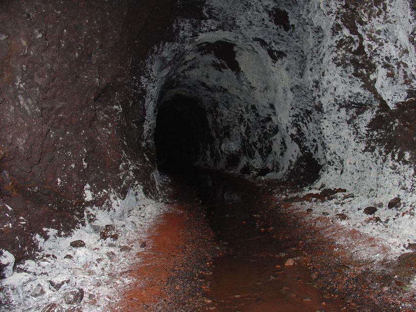
Environmental security, geological hazards and management
© 2013 ISBN 978-84-616-2005-0

The method of ground water extraction from basaltic islands varies significantly based on
geology, regional hydrology, land use, the amount of water to be extracted, dike tunnels
or mines have been dug into the mountains over the last 100 years.They contain concrete
channels or large water pipes to take the water to the populated and agricultural areas, for
instance; Tenerife´s island crops consume over 80% of water resources.

On the other hand, There are special farming systems in the islands, especially in semi-arid
land, have developed unique systems of water harvesting (Gavia, Mareta, Enarenado…), which
have combined water resources collection and soil conservation.These works are classified
according to their location, efficiency and agricultural use. Mainly these facilities are located
in the channels of ravines, generally dry. The works studied are been built in other semi-arid
lands as in the Middle East.

                        Figure 1. Dike tunnel in Tenerife Island (Western)

Forest in Canary Islands, has a protective function with respect to water quality and water-
related hazards, as well as providing an adecuate water supply for the forest ecosystems. An-
other important point is the fog precipitation, this occurs from 500 meters above sea level
to 1,400 meters. This water resource is intercepted by the branches and trunks of trees (Pine
and Laurisilva) an increase in water availability in the area.

2. EROSION AND TORRENTIAL RAIN

Canary Islands have a torrential rainfall pattern, this produces erosion; erosion is a natural pro-
cess of a physical and chemical nature that degrades, destroys and transports rock and soil of
the Earth’s crust. This process can be accelerated, modified or corrected by anthropic action.

Soil erosion is one form of soil degradation along with soil compaction, low organic matter,
loss of soil structure, poor internal drainage, salinization, and soil acidity problems. These other
forms of soil degradation, serious in themselves, usually contribute to accelerated soil erosion.

                                                170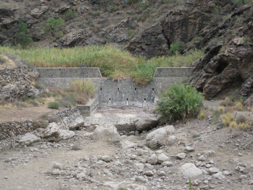
Part 2
                                                               Water Management and Protection

On occasions, torrential rainfall occurs: this rainfall leads to important erosion processes. Both
rainfall and runoff factors must be considered in assessing a water erosion problem. Runoff
can occur whenever there is excess water on a slope that cannot be absorbed into the soil or
trapped on the surface.

                     Figure 2. Erosion process in Lanzarote Island (Eastern)

The main factors that are involved in the generation of solid and liquid runoff that reach
volcanic ravines, and are then transported by them, are related to the characteristics of the
precipitation and the area affected (slope, vegetation), the water erosion and the dynamics
of the runoff. The amount of runoff can be increased, if infiltration is reduced due to soil
compaction and crusting.

2.1. Water erosion

The process of water erosion begins with rain that falls on the soil breaking it up, subse-
quently runoff is formed, a laminar flow from the land higher up the slope is created, which
flows downwards in small rills that transform quickly into large gullies that are difficult to
correct and deal with.

The appearances of gullies are closely connected to inappropriate land use practices. Gulley
erosion is a reflection of surface erosion and is the most extreme result of this erosion. This
type of erosion is preceded by other processes (sheet and rill), due to the increase in runoff
volume and speed.

The erosion process is considered to be one of the most serious worldwide environmental
problems, associated, to a large degree, with the loss of forest cover. The way erosion works is
by detaching material, transporting it (by water, wind…) and finally depositing it. Water erosion
can also occur at depth; this effect is related to large displacements of land by the hidden
action of water filtering down. Water lubricates land and creates the conditions necessary for
displacement by gravity. Materials slide by shearing when a certain angle of slope is reached.

                                               171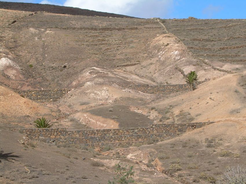
Environmental security, geological hazards and management
© 2013 ISBN 978-84-616-2005-0

            Figure 3. Dam of sediments in a ravine at Gran Canaria Island (Eastern)

Another effect of water erosion, especially when caused by torrential rainfall, is when the soil
becomes saturated with water after many days of rain. This ends up provoking landslides on
slopes: the consequences and size of these depend on the angle of the slope on which they
occur.

2.2. Wind erosion

Wind erosion is the loss of the soil surface layer by the wind action. This is a selective process
because it affects only particles on the soil surface and depends on grain diameter. Wind ero-
sion is a major geomorphological process in arid and semi-arid areas. The rate and magnitude
of soil erosion by wind is determined by factors such as particle sizes: very fine particles
can be suspended by the wind and then transported great distances; fine and medium-size
particles can be lifted and deposited. Other factors are regional climate and wind. The speed
and duration of the wind has a direct relationship with the extent of soil erosion. Vegetation
cover is also important, as the lack of permanent vegetation cover in certain locations has
resulted in extensive erosion by wind, is usually at the Eastern Islands.

3. FLOOD EFECTS
The dictionary defines a flood as a great flowing or overflowing of water, especially over
land not usually submerged. Floods are caused by sudden changes in water level, so the level
exceeds its natural confinement and covers a portion of land not previously covered.

Heavy rains along the south-western zone of the Canary Islands are common during a few
days most of the years,the destructive power of a flood is mainly due to two factors. First,
there is the power of erosion and transport of material by the water when a rise in its level
occurs. Secondly, there is the fact that floodplains in their morphology and natural wealth
provide very favourable conditions for human settlements,With higher velocities, streams

                                               172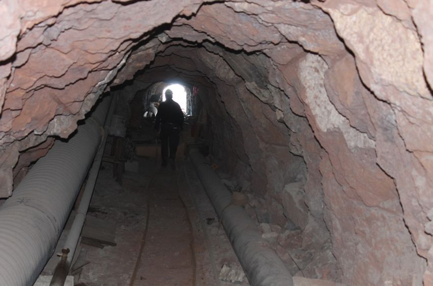
Part 2
Water Management and Protection
are able to transport larger particles as suspended load. Massive amounts of erosion can be
accomplished by flood waters.
4. OVEREXPLOTATION OF WATER RESOURCES
The immediate consequence of the overexploitation of water resources is the salinization
of these resources; this fact significantly affects the land and its processes, with the result
being erosion. In addition, the overexploitation of coastal aquifers leads to marine intrusion
and worsens the quality of the water extracted, which in many cases is used to irrigate crops
producing soil problems. On most of Canary Islands, population growth is putting increas-
ing pressure on water resources.
5. FOREST FIRES
Forest in Canary Islands has a huge role in the island´s water resources, one way are the fog
precipitation, when there are clouds in the pine forests on the upper part of the island the shape
of the needle causes the water vapour to condense and form droplets on the needles. The
drops run off the needle and seep into the ground re-suppling the water reserves throughout
most of the year, on the other hand Canary forest are the main factor to conserve the soil
and reduce the erosion processes ( water and wind erosion).
Forest fires are one of the main causes of erosion and destruction of the soil, especially
when the first autumn or winter rains are torrential.
During a fire, the undergrowth disappears, allowing elements that were fixed to be moved,
so much large-diameter necromass, stones and, above all, rolling pine cones are able to cre-
ate secondary flashpoints normally beyond the first line where human efforts are trying to
control the fire.
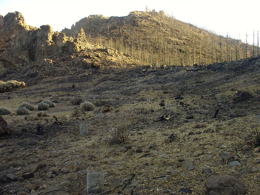
Figure 4. Burned areas by wildfire on the island of Tenerife
173Environmental security, geological hazards and management
© 2013 ISBN 978-84-616-2005-0
One of the most serious and immediate consequences that occur after a forest fire is the
dragging of ash and bare soil towards rivers. This can be catastrophic for populated areas
and towns near the forest.
In addition, forest fires generate an important distortion in the accumulation of carbon in
soil. This element, the main component of organic material, plays a key role in soil fertility,
water retention, and resistance to erosion.
As for hydrological implications, a forest fire generates a significant reduction in infiltration.
Thus, when the first rains arrive following a forest fire, the runoff on burnt soil can double
or even triple as a result of the volume of solids in suspension, and the impermeability and
lack of infiltration capacity of the soil surface.
Erosion and soil effects of a forest fire can be classified as follows (Contreras et al, 2007):
• Less soil aggregation
• Reduction in organic material
• Loss of nutrients
• Reduction in surface roughness
• Increase in surface runoff
6. SOIL SALINIZATION
Salinization is the accumulation of soluble salts of sodium, magnesium and calcium in soil
to the extent that soil fertility is severely reduced. This soil problem leads to an excessive in-
crease of water-soluble salts in the soil. The accumulated salts include sodium, magnesium,
potassium and calcium, chloride, sulphate, carbonate and bicarbonate.
Salinization on the soil surface occurs where the following conditions occur together:
• The presence of soluble salts, such as sulphates of sodium, calcium and magnesium in the soil
• A high water table
• A high rate of evaporation
• Low annual rainfall
174Part 2
Water Management and Protection
One of the effects of salinization is that salts in the soil increase the efforts required by plant
roots to take in water. High levels of salt in the soil have a similar effect as droughts by mak-
ing water less available for uptake by plant roots. Salty groundwater may also contribute to
salinization. When the water table rises, the salty groundwater may reach the upper soil layers
and, thus, supply salts to the rootzone.
The control of sodium and salinity hazard is required for irrigation.
7. HYDROCHEMICAL CHARACTERISTICS AND WATER QUALITY
Water quality is the critical factor that influence on human health and quantity and quality.
fluoride are naturally present in deep parts of the islands´s aquifer. This natural fluoride
comes from the geological formations.Excess fluorine is recognized as the most hazardous
leachate in water supplies.In parallel with the progressive decline in groundwater levels we
have seen a worsening in the quality of groundwater. The factors that influence this degrada-
tion can be naturally occurring, such as the exploitation of fossil water with more mineraliza-
tion and dissolved CO2, or anthropogenic: saltwater intrusion, pollution and contamination
by irrigation returns. The presence of increasingly saline waters, sometimes with evidence
of seawater intrusion in coastal aquifers or nitrate concentrations that sometimes reach and
exceed 400 mg / L and pesticide residues, all of these are clear indications that these phe-
nomena are occurring in the islands, although in each case must be studied in detail to be
characterized. Recent eruptions generally have caused few water-quality problems also.
Figure 5. Carbonates in a mine of water
175Environmental security, geological hazards and management
© 2013 ISBN 978-84-616-2005-0
8. ENERGY FOR PRODUCING WATER. DESALINATION PLANTS
Desalination is the process of creating fresh water by removing salt from the sea. Reverse
osmosis is currently the most commonly found type of desalination, and multistage flash
distillation is the method that currently produces the most amount of desalinated water in
Canary Islands, This process requires large amounts of energy. In the eastern islands up to
1965 was an water stress situation, extreme aridity and scarcity of water resources are the
main problem in the water planning, in this case, due to the very arid climate, water is ex-
tremely limited on this islands, these islands Lanzarote and Fuerteventura have also shown
the viability of using desalination as a sole source for water, generally desalination introduces
a new variable in the limits of development, expandability of natural resources, and carrying
capacity of the environment. In the Canary Islands desalination represents more than 30%;
for Lanzarote Island, this figure is around 80%. The increment of desalination has meant ad-
ditional energy consumption; currently desalination represents in the islands approximately
10% of electricity consumption, in some islands this percentage raises up to 25%. This situ-
ation, in the future, could be unsustainable.
9. DISCUSSION AND CONCLUSIONS
Western Islands generally rely on ground water for community and domestic supply as the
surface water sources are not reliable due to fluctuating stream flows and difficulty of build-
ing reservoirs because of land area constraints. Water and its use have special characteristics
in the Canary Islands when compared with the mainland. The water supply is not unlimited
so measures are taken to ensure continuity of supply throughout the dry summer months.
In the Western Islands intensive groundwater exploitation for more than a century, and es-
pecially in the last half century, has produced a deep change in groundwater flow, the drying
up of springs and the depletion of aquifer reserves.
Water quality is increased in quantity of salts and volcanic gases, mainly Fluor (4-8 mg/L), we
noticed a decline in groundwater levels. The mining of water is replaced by the desalination
of water although this is much more expensive and less sustainable due to rising cost of oil.
The integrated management of surface water and groundwater for drinking and irrigation is
to solve the water issues. Canary Islands couldn´t recourse to water importation.The Canary
Islands are totally dependent on the resources that nature provides. Increasing populations,
tourism and changeability of rainfall regimes require a greater degree of preparedness than that
needed in most continental regions. Western Islands, such as Tenerife, Gomera y La Palma are
benefited with substantial groundwater storage while on Eastern Islands geological conditions
and rainfall severely limit groundwater availability. On some islands, mostly in the Eastern, de-
salination powered by expensive imported fuel, provides the drinking water at a high cost. In
some areas residents perforce rely mostly on rainwater catchment like for fog rain collectors.
176Part 2
Water Management and Protection
10. POSSIBLE TOPICS FOR FUTURE RESEARCH
This paper set out to investigate the role of water resources in the Canary Islands such as
management, threats and protection. The volcanic islands are a global laboratory due to the
large number of wells and mines that exist in the subsurface; this knowledge could be trans-
ferred to other volcanic regions. There are many topics opened for future research, we could
summarize in;
• Groundwater availability for water supply and irrigation
• Submarine groundwater discharge
• Groundwater quality affected by natural and anthropogenic contaminants
• Groundwater recharge
• Orography and precipitation variations
• Mass (erosion) loss due to heavy rainfall
• Flooding due to heavy rains & storm surge
• Rainwater harvesting
• Seawater intrusion into sewer systems
• Water for energy production on islands
• Efficiency of desalination plants
REFERENCES
Web of Civil Defense, Ministry of Civil defense & Emergency Management, New Zealand Govern-
ment: http://wwwcivildefense.govt.nz
SANTAMARTA-CEREZAL, J.C. et al.(2013); Hidrología y Recursos Hídricos en Islas y Terrenos Volcánicos.
Colegio de Ingenieros de Montes. Tenerife. Spain.
SANTAMARTA-CEREZAL, J.C. & NARANJO BORGES, J., Ed. (2013); Ingeniería Forestal y Ambi-
ental en Medios Insulares. Técnicas y Experiencias en las Islas Canarias. Colegio de Ingenieros de Montes.
Tenerife. Spain.
SANTAMARTA-CEREZAL, J.C. & HERNÁNDEZ.GUTIÉRREZ, L.E., & RODRÍGUEZ
LOSADA, J.A.,(2010);Volcanic dikes engineering properties for storing and regulation of the underground
water resources in volcanic islands.CRC Press.The Netherlands.
SANTAMARTA-CEREZAL, J.C.& RODRIGUEZ MARTÍN, J.(2011); Advances in explotation of un-
derground water resources in volcanic islands. Experiences and methods in the Canary Islands. Water Resource
Sustainability Issues on Tropical Islands. Honolulu, Hawaii, USA.
SANTAMARTA-CEREZAL, J.C. & RODRIGUEZ MARTÍN, J.(2011); Traditional systems for water
harvesting and soil conservation in volvanic islands.Case study.The Canary Islands.Spain.Europe. Water Re-
source Sustainability Issues on Tropical Islands. Honolulu, Hawaii, USA.
SANTAMARTA-CEREZAL, J.C. (2012);Study of Techniques to Increase Water Resources and Run-Off in Semiarid
Regions. The Case of The Canary Islands and Israel.Journal of the Faculty of Forestry,Istanbul University. Vol.62.
Turkey.
177Environmental security, geological hazards and management
© 2013 ISBN 978-84-616-2005-0
SANTAMARTA-CEREZAL, J.C. & GUZMAN, J. & NERIS, J.et al. (2012); Forest Hydrology, Soil Conservation and
Green Barriers in Canary Islands.Notulae Botanicae. Vol.40.Romania.
178You can also read