SUPPORT SUSTAINABLE WATER MANAGEMENT AND IRRIGATION MODERNIZATION FOR NEWLY RECLAIMED AREAS
←
→
Page content transcription
If your browser does not render page correctly, please read the page content below
©FAO Egypt

SUPPORT SUSTAINABLE WATER MANAGEMENT AND
IRRIGATION MODERNIZATION FOR NEWLY RECLAIMED AREAS

M ay 2 0 2 0

SDGs:

Countries:          Egypt

Project Codes:      TCP/EGY/3604

FAO Contribution:   USD 400 000

Duration:           1 February 2018 – 31 December 2019

Contact Info:       FAO Representation in Egypt
                    FAO-EGY@fao.org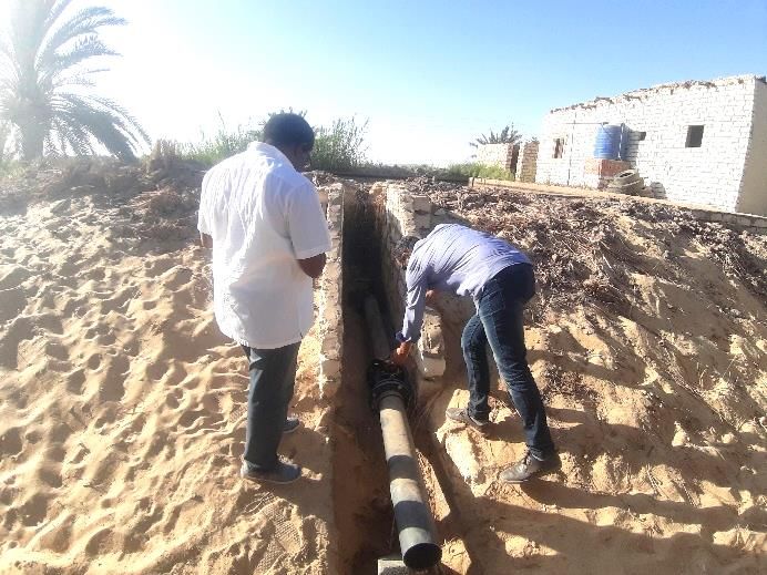
SUPPORT SUSTAINABLE WATER MANAGEMENT AND TCP/EGY/3604
IRRIGATION MODERNIZATION FOR NEWLY RECLAIMED AREAS
Implementing Partners IMPACT
Ministry of Water Resources and Irrigation (MWRI),
The project not only contributed to increasing water use
Irrigation Improvement Sector, Groundwater Sector;
efficiency but also added value to that water by taking
Ministry of Agriculture and Land Reclamation (MALR),
into account water productivity. MWRI and MALR now
Agriculture Research Center.
have a full package of technical information to manage
Beneficiaries newly reclaimed areas. The lessons learned under the
MWRI (Irrigation Improvement Sector, Groundwater project will benefit all GW-irrigated areas and should be
Sector) and MALR (Agriculture Research Centre). Indirect expanded to other areas in the country. In this context,
beneficiaries include farmer organizations and water user a practical network of future leaders in those institutions
associations. involved in the GW sector has been established.
Country Programming Framework (CPF) Outputs ACHIEVEMENT OF RESULTS
CPF 2. Priority Area B: Improving productivity and
The project successfully achieved its aims. It set up and
efficiency in the agricultural sector: 2.2. Irrigation
tested an automated water consumption monitoring and
modernization.
water accounting system at two selected pilot areas (Siwa
Oasis and Farafra Oasis) in the newly reclaimed areas,
for use by MWRI and MALR, the ministries responsible
for monitoring water consumption for agricultural
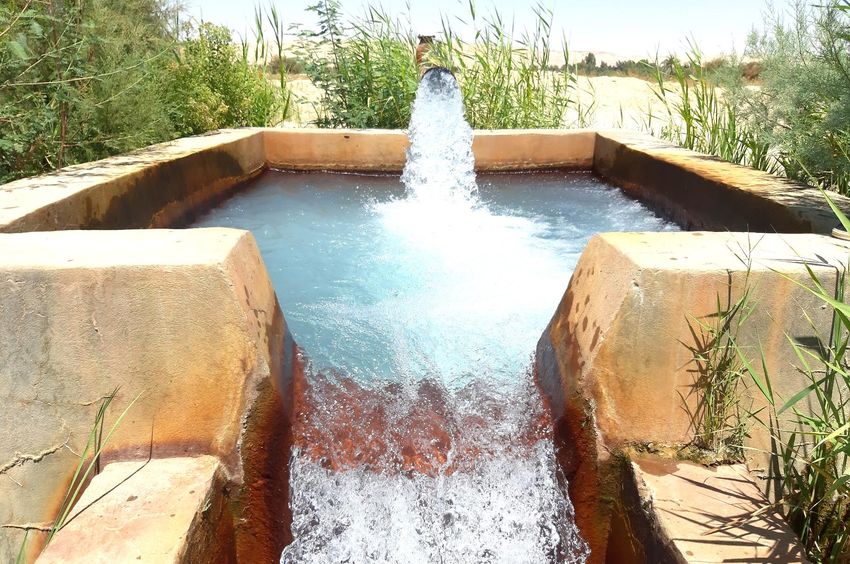
purposes. A drip and subsurface irrigation system was
installed in both pilot oases. The project developed a
land development monitoring tool based on RS and
Geographic Information System (GIS) for use by MALR,
as well as standard processes and methodologies for field
data collection and analysis. Training was given in the
use of these to ministry staff. It provided agricultural
extension services through farmer field schools (FFSs)
©FAO Egypt
for more than 50 farmers, organized farmer-to-farmer
visits and other means of technology transfer, including
BACKGROUND study tours to Australia and Italy. All the tools developed
A key challenge for the agriculture sector in Egypt is were successfully applied at pilot level and can be
to feed its growing population in the context of increasing expanded to other areas at national level.
demand on the finite water resources and a trade
deficit. Horizontal expansion into new land in the desert
has long been strategic in meeting this challenge. Major
land reclamation activities have been initiated under
the National Reclamation Project, with the objective of
increasing agricultural land area by two percent, making
agricultural land nine percent of the total area of Egypt.
These activities aim to sustainably use the groundwater
resources of the Nubian Sandstone Aquifer and other
GW systems in different parts of Egypt to irrigate an area
of up to 1.5 million feddan (630 000 ha). To this end, the
Government of Egypt requested FAO support to the land
reclamation programme. Within the Regional Initiative
on Water Scarcity, FAO would pilot a data and information
management system, based on monitoring and remote
sensing (RS) data to assist MWRI and MALR to monitor
water consumption and water productivity in the newly
©FAO Egypt
reclaimed areas.
1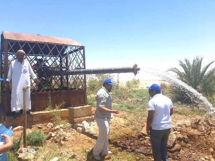
SUPPORT SUSTAINABLE WATER MANAGEMENT AND                                                                  TCP/EGY/3604
IRRIGATION MODERNIZATION FOR NEWLY RECLAIMED AREAS

                                                               SUSTAINABILITY
                                                               1. Capacity development
                                                               Egypt is aware of the need to transform agriculture to
                                                               reduce its water requirements. The project contributed
                                                               to knowledge in support of government efforts and
                                                               related policies, and established a collaborative
                                                               technique in two different remote areas. The impact will
                                                               be sustained by a follow-up programme in coordination
                                                               with MWRI and MALR. Both ministries are already
                                                               involved        in the country strategy for reclaiming four
                                                  ©FAO Egypt
                                                               million feddan, ensuring that the project is sustainable.
IMPLEMENTATION OF WORK PLAN                                    Sustainability on the ground will also be ensured by the
                                                               inclusion in project activities of young professionals.
Project implementation was delayed by a long
procurement process. Despite this, the project achieved        2. Gender equality
its outputs within the scheduled timeframe and budget.         Although gender equality was not highlighted in the
Some support, above all to study tours, was provided           Project Document, the project was implemented with a
by project GCP/RNE/009/SWE.                                    gender balance in all activities, including data collection
Envisaged risks included the unavailability of existing        and travel to remote areas. Women represented one
GW models, the inadequate sharing of data by                   third of trainees and of the MWRI team, and 25 percent
governmental institutions, organizational insufficiencies,     of the team from MALR. Activities under the Letter of
the delayed installation of measuring and data transfer        Agreement (LoA) with Heliopolis University for
equipment, difficulties with technical systems and data        Sustainable Development (HU) were led by a woman,
transmission, and illegal attempts to bypass the regulated     while the team from the Regional Centre for Training and
water supply. These risks did not materialize or were          Water Studies (RTCWS) comprised two women and three
successfully mitigated by the project. A further risk was      men. Of the four project consultants, one (GW) was
the location of the selected site (about 900 km from           female.
Cairo), the management of which required considerable
                                                               3. Environmental sustainability
effort in terms of planning, preparation and travel.
                                                               A significant effort was made to address environmental
FOLLOW-UP FOR GOVERNMENT ATTENTION                             issues, including the future of the finite quantity of GW
                                                               and salinity mitigation, as well as economic sustainability.
It is recommended that detailed analyses of the water
accounting and monitoring systems developed in the two         4. Human Rights-based Approach (HRBA) – in particular
pilot sites be published. Long-term data collection of         Right to Food and Decent Work
water consumption should also be conducted. The                Although this topic was not specifically addressed in the
progress of the irrigation systems installed in the pilot      Project Document, the unfinalized survey conducted on
sites should be followed up and the results of the training    farmer practices with water may reveal some issues
activities disseminated as a tool for land expansion           related to labour conditions.
programmes at country level.
                                                               5. Technological sustainability
                                                               Taking into account local capacity, resources and
                                                               knowledge, the project introduced various technological
                                                               approaches and tools that are very important, such as
                                                               drip and subsurface irrigation, as well as free RS and GIS
                                                               tools.

                                                  ©FAO Egypt

                                                                                                                         2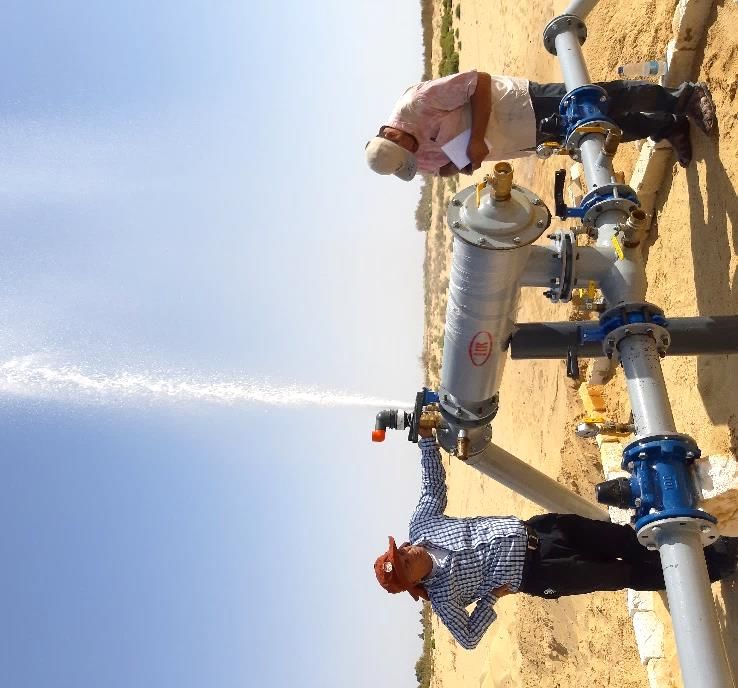
SUPPORT SUSTAINABLE WATER MANAGEMENT AND TCP/EGY/3604
IRRIGATION MODERNIZATION FOR NEWLY RECLAIMED AREAS
DOCUMENTS AND OUTREACH PRODUCTS
FAO. 2018. Report of the project inception workshop,
April 2018.
FAO. 2019. Progress and final report. Agriculture
in newly reclaimed areas. LoA with Horticultural
Research Institute (HRI), MALR.
FAO. 2019. Progress and final report. Irrigation
in newly reclaimed areas. LoA with MWRI.
FAO. 2019. Progress and final report. Capacity
Building for newly reclaimed areas. LoA with HU.
FAO. 2019. Progress and final report. Design,
©FAO Egypt operation and maintenance of modern irrigation
systems. LoA with RTCWS.
6. Economic sustainability FAO. 2019. Final report. Australia study tour. LoA
with International Centre of Excellence in Water
The project was complemented by project Resources Management (ICE WaRM).
GCP/RNE/009/SWE funded by the Swedish International
FAO. 2019. Final report. Italy study tour. LoA
Development Cooperation Agency. Technical tools from with Mediterranean Agronomic Institute of Chania
the FAO Water Productivity Open-access portal (WaPOR) (CIHEAM).
were used for crop mapping in Siwa. FAO. 2019. Final report. GIS national consultant.
All the products and services provided by the project are
FAO. 2019. Final report. GW national consultant.
free and applicable. This was planned from the beginning
of the project to ensure sustainability. FAO. 2019. Final report. Agronomist (Siwa crop
mapping) national consultant.
FAO. 2019. Final report. Integrated water resources
management international consultant.
2019. Back-to-office report (BTOR). October:
Cairo Water Week. Technical session 4: “Support
Sustainable Water Management in Newly Reclaimed
Areas”.
2019. BTOR. FAO and HU. Training manual. “Support
Sustainable Water Management in Newly Reclaimed
Areas”.
2019. BTOR. FAO and RTCWS. Training manual.
“Design, Operation and Maintenance of Modern
Irrigation Systems. Under the Project Titled Support
©FAO Egypt
Sustainable Water Management in Newly Reclaimed
Areas”.
3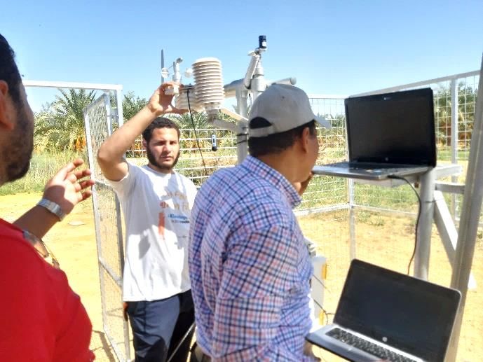
SUPPORT SUSTAINABLE WATER MANAGEMENT AND                                                                              TCP/EGY/3604
IRRIGATION MODERNIZATION FOR NEWLY RECLAIMED AREAS

 ACHIEVEMENT OF RESULTS - LOGICAL FRAMEWORK
   Expected
                  Sustainable and long-term oriented use of available water resources
   Impact
                  Controlled and sustainable use of the finite water resources of the GW aquifer system and maximized water
                  productivity
                                  1. Information management system with databases, spatial analysis tools and web portal
                                      established and operational.
                  Indicator
                                  2. Training curriculum for FFSs developed, with farmers receiving agricultural extension services
                                      through FFS training in pilot areas.
                                  1. 0
                  Baseline
                                  2. 0
                                  1. 1
   Outcome        End Target
                                  2. 20
                                  Databases and spatial analysis tools were established, to be used for the following: crop
                                  mapping, GW management, sustainable and efficient agriculture.
                                  A training curriculum for FFSs was developed. This highlighted water management knowledge
                  Comments
                                  and increased knowledge and understanding of participants on integrated water management.
                  and follow-up
                                  A practical network of future leaders in the GW sector across participants’ institutions (formally
                  action to be
                                  and informally) to build greater transboundary benefit-sharing and cooperation was established
                  taken
                                  during training and study tours. Participants’ awareness of the benefits of collaboration across
                                  institutions was raised.
                                  This effort will be continued within target ministries as a result of the technical skills obtained.

                  Water accounting and monitoring system for water consumption

                  Indicators                                                  Target                                        Achieved
   Output 1
                                                                              Implementation in selected pilot area
                  National assessments of water accounting baseline.          (Siwa Oasis as a case study) and in           Yes
                                                                              Farafra Oasis.
   Baseline       0
                  This output was fully implemented and reported through the LoA with MWRI. Water wells and springs are the
                  only water supply available in Siwa Oasis, with the majority tapping the shallow carbonate aquifer at depths of
                  between less than 10 and 120 m and few deep wells (±1 000 m). These wells pump 236.6 million m3 per year to
   Comments       meet water demand for agriculture and municipal uses. The monitoring system for water consumption depends
                  on weather data to calculate crop water requirements as indicated by Modified Penman-Monteith equation.
                  Crop mapping using WaPOR for the whole of Siwa Oasis was collected with acceptable accuracy (90%).
                  Follow up publication with detailed analysis is recommended.
                  Conduct situational analysis and gap/opportunity analysis
                  Achieved        Yes
                                  A GW situational analysis and gap/opportunity analysis was conducted and made available by
   Activity 1.1                   MWRI.
                  Comments        An assessment of current/future crop yield in the pilot areas was undertaken to understand
                                  impact of changed water application on plant productivity. The assessment is detailed in a
                                  report of HRI/MALR.
                  Develop water consumption monitoring and data transmission system and water accounting system
                  Achieved        Yes
                                  At pilot level, a water consumption monitoring system was installed and data were collected.
   Activity 1.2                   Monitoring depends on flowmeters and climatological data for calculation of theoretical crop
                  Comments        water requirements. Date palm and olive trees are the main crops. Data were collected and
                                  analysed for the applied irrigation systems (drip and surface irrigation).
                                  Long-term follow-up data collection is recommended.

                                                                                                                                       4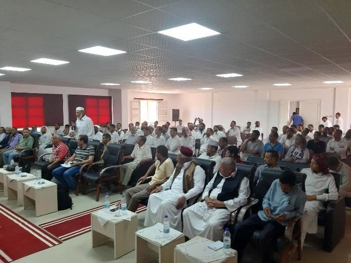
SUPPORT SUSTAINABLE WATER MANAGEMENT AND                                                                                TCP/EGY/3604
IRRIGATION MODERNIZATION FOR NEWLY RECLAIMED AREAS

                Water productivity maximization methodologies and database developed, tested and made operational to
                stakeholders
                Indicators                                                  Target                                         Achieved
                                                                            Google Earth Engine selected as a free
                                                                            tool and platform for development.
                                                                            Crop mapping with high accuracy
 Output 2
                                                                            conducted by official staff of MWRI and
                Assessment of water productivity in newly reclaimed
                                                                            MALR.
                areas. Siwa Oasis was selected as an example of a                                                          Yes
                                                                            Weather station with one-hour time
                newly reclaimed area.
                                                                            series installed to calculate crop water
                                                                            requirements using recommended
                                                                            software.
                                                                            Field verification implanted at the site.
 Baseline       0
                In line with the achieved results and opportunity analysis, a drip and subsurface irrigation system was installed in
                Siwa and Farafra Oases. Farmers intended to plant date palm, olive and intensive agriculture olive. Follow-up of
 Comments
                their progress and achievements in the modernized pilots, as well as of progress of the wider implementation of
                a modern irrigation system in the pilot areas, is recommended.
                Develop the methodology and GIS system for RS-based monitoring of land development, ground verification
                Achieved          Yes
                                  A methodology was developed to use cloud computing and big data for vegetation monitoring.
                                  Google Earth Engine was selected as a platform to develop tools to access RS images (Sentinel
                                  2), enabling visualization, processing and interpretation of RS data through the GIS consultant.
                                  This made it possible to process enormous amounts of satellite data in high spatial resolution
                                  and work with satellite data in time series for the first time. The tool includes the following
                                  functions:
                                  1. Uploading an area of interest (as a shapefile) for monitoring development.
                                  2. Setting the start/end date of a period of interest
 Activity 2.1
                                  3. Creating a true colour composite for the time period for the area of interest.
                Comments
                                  4. Creating a Normalized Difference Vegetation Index (NDVI-Max) composite for the time
                                      period for the area of interest to map the vegetation extent during this time period.
                                  5. Clicking at a point of Interest to plot the change in NDVI during the period of Interest.
                                  6. Downloading a true colour composite image, generated using satellite images captured
                                      during the period of interest, for the area of interest.
                                  7. Downloading a NDVI-max Image, based on (NIR-RED) bands of satellite images captured
                                      during the period of interest, for the area of interest.
                                  8. The data are diverted to Google Drive and can then be locally downloaded to the user PC.
                                  9. Upscaling for implementation at a wider scale.
                Develop and test the methodology for agricultural data collection and central database storage
                Achieved          Yes
                                  Siwa vegetation monitoring:
                                  1. GIS tools were used to explore change in vegetation in Siwa with a focus on selected area.
 Activity 2.2
                                  2. True colour composites were generated for the first six months of 2016 and 2019.
                Comments
                                  3. NDVI maps were generated to observe the change in vegetation.
                                  True colour composite and NDVI maps for the Siwa Oasis were created for crop mapping activity
                                  through a team from MWRI and MALR.
                Develop agricultural data and water productivity analysis procedures, agricultural extension services
                Achieved          Partially
                                  The project pioneered a holistic approach for comparing the effect of surface and drip irrigation
                                  systems used in Siwa Oasis on date palm and olive tree production through the LoA with HRI.
 Activity 2.3                     The resulting detailed information should help growers, experts and local authorities to adapt
                Comments          the most appropriate irrigation method to be used for the sake of agricultural and water
                                  sustainability. Data were gathered from field missions by HRI researchers from January to
                                  December 2019. The effect of surface and drip irrigation system on date palm and olive
                                  production was measured. It is recommended that the results be published through MWRI.

                                                                                                                                       5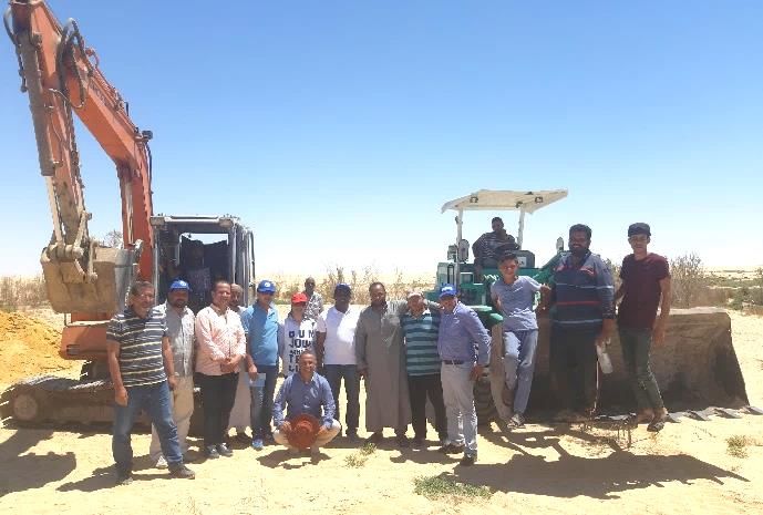
SUPPORT SUSTAINABLE WATER MANAGEMENT AND TCP/EGY/3604
IRRIGATION MODERNIZATION FOR NEWLY RECLAIMED AREAS
Capacity building for the technical staff and relevant stakeholders provided
Indicators Target Achieved
Output 3 Local and international capacity building for different
levels of government staff (senior, mid-career, young
professional and site staff) from MWRI and MALR, More than 200 trainees. Yes
considering gender equity. Training of trainers
provided.
Baseline 0
Detailed capacity building through the LoAs with HU and RTCWS was provided in the following:
1. Water accounting.
2. Water productivity.
Comments 3. Free GIS and RS tools.
4. Design, operation and maintenance of modern irrigation systems.
Training results/programmes should be widely disseminated by MWRI as well as the Project Management Unit
of MALR as a tool for land expansion programmes at country level.
Conduct GIS-based land development tool training
Achieved Yes
The project trained 25 engineers from MWRI and MALR through an LoA with HU. The training
consisted of the following:
Collection of updated RS datasets (including satellite imagery).
Activity 3.1
Database management.
Comments
Incorporation of updated datasets into the GIS system.
Visualization of land development for easy interpretation by decision makers.
Updating of LULC maps for easy communication of land development.
Advanced courses are requested as a follow-up.
Conduct automated water consumption monitoring system training
Achieved Yes
The project trained 25 engineers from MWRI and MALR through an LoA with HU. The training
consisted of the following:
Activity 3.2
Practical exercises as part of the training.
Comments
Database management.
Water consumption monitoring, related models and telemetric data transmission systems.
Data quality control and plausibility.
Conduct field monitoring training
Achieved Yes
The project trained 25 engineers from MWRI and MALR through an LoA with HU. The training
consisted of the following:
Conduct on-the-ground measurements of water tables (to compare with automated water
table measurements) at reference wells, measure water quality directly in the field and in
Activity 3.3
collaboration with identified water laboratories. Training in the operation of the required
Comments
measuring devices included.
Train MALR staff how to consult with farmers and collect data on: i) crop types grown and
yields achieved; ii) agricultural methods applied; and iii) training of field survey experts in
conduct of soil surveys to assess soil quality. Other aspects covered in the training included
protocolling and database management.
Conduct data analysis training
Achieved Yes
The project trained 25 engineers from MWRI and MALR through an LoA with HU. The training
Activity 3.4
consisted of the following:
Comments
Data analysis training including introduced element on how to assess uncertainties and how
to identify errors in the data sets in consultation with FAO.
6SUPPORT SUSTAINABLE WATER MANAGEMENT AND TCP/EGY/3604
IRRIGATION MODERNIZATION FOR NEWLY RECLAIMED AREAS
Conduct agricultural extension/farmer-to-farmer experience exchange and FFS training, etc
Achieved Yes
Training was provided to 75 farmers in Siwa Oasis during August-September 2019 through an
LoA with MWRI. The training included the following:
Definition of water resources management in Siwa and description of main challenges facing
efficient water management.
Concept of water user associations including forming and operation concepts.
Modern irrigation design, operation and maintenance in the new lands. The course included
the advantages of modern irrigation versus flood irrigation, the components of a modern
irrigation network (sprinklers or drip), and the operation and maintenance procedures
needed to effectively operate a modern irrigation network.
Activity 3.5 Trainees also made a site visit to a farm in Siwa operating under modern irrigation systems.
Comments Training and workshop programmes were held for a large number of growers, agriculture
counterpart staff and participation of private sector entrepreneurs. More than 50 stakeholders
participated in the training and workshops. About 90 growers of date palm and olive in Siwa and
+10 agricultural extension staff participated in the programmes.
A field visit to the village of El-Shahaim, training activities to introduce technology of good
agricultural practices, irrigation methods in newly reclaimed lands, symptoms of nutrient
deficiency and integrated pest management programme on olive trees and date palm.
Good practices introduced for date palms and olive trees especially in newly reclaimed
lands, and all stakeholders’ questions answered. The training and workshops contributed to
developing knowledge and raising awareness of Siwa growers concerning good agriculture
practices for date palms and olive trees, which is expected to lead to increased income.
Conduct study tour for limited technical staff
Achieved Yes
Within the framework of this project and project GCP/RNE/009/SWE, the following study tours
were organized:
1. ICE WaRM, Australia, organized a High-level study tour through an LoA on modern irrigation
in Australia in November 2019. The study tour aimed at supporting water monitoring
systems and increased water productivity. The four participants were from Minister’s office,
site engineers and related research institutes. Trainees summarized the possible applications
of knowledge gained as:
Use of water treatment technology to produce irrigation water.
Separate title of water and land in the newly reclaimed areas as a first initiative.
Introduce water trade in the new areas as a way to share water.
Use pipes instead of channels.
Reform water law to accommodate use of recycled (treated) water for vegetable crops.
Activity 3.6 Review water governance arrangements.
Comments Adopt new technologies to produce high-quality waste water.
Cooperate in the future on water efficiency in the newly reclaimed areas.
Create awareness in the community of alternative water sources and water efficiency.
“Think out of the box” - a lesson of drought – e.g. changing cropping patterns.
Give more attention to socio-economic aspects.
2. CIHEAM, Bari, Italy, through an LoA organized the second study tour. Four participants were
from the Project Management Unit, Minister’s office, site engineers and related research
institutes. The following were achieved as a result of the study tour:
Enhanced understanding of on-demand and rotational irrigation systems.
Implementation, design and arrangement, including performance evaluation, of
pressurized irrigation systems.
Detailed work plan for implementing project activities, including farmers’ feedback.
Participants gained considerable knowledge about leading edge technology in the irrigation
field in Italy that can then be implemented in Egypt.
7SUPPORT SUSTAINABLE WATER MANAGEMENT AND TCP/EGY/3604
IRRIGATION MODERNIZATION FOR NEWLY RECLAIMED AREAS
Pilot application of developed processes and tools in selected areas of interest (piloting)
Output 4
Indicators Target Achieved
Pilot selection and tools identified. Processes designed and developed. Yes
Baseline 0
This output achieved the following:
Modern irrigation systems installed for 52 feddan.
Comments Weather station installed in Siwa to compute effluent treatment plant.
Platform developed to access RS images through Google Earth Engine.
Crop mapping measuring for Siwa using free tools (WaPOR) with 92% accuracy.
Define pilot areas
Achieved Yes
At an earlier stage, different pilots were proposed. It was necessary to find a suitable pilot as an
example of newly reclaimed area. The MWRI and MALR project teams recommended Siwa as
the first site. The west side of Siwa Oasis, known as Old Siwa, is where farmers first began
cultivation under old irrigation techniques, specifically flood irrigation. The east side of the oasis
Activity 4.1 is mostly newly reclaimed areas with large ownership. This side depends in many areas on
Comments modern irrigation techniques (sprinkler and drip irrigation). Drainage water flows to the lakes
though either free discharge from drains or pump stations at the end of low-level drains. Based
on borehole samples data in Siwa, Siwa GW aquifers may be classified into two main aquifers,
cracked limestone aquifer and Nubian sandstone aquifer.
The second site was Farafra Oasis. Based on an official letter from MWRI, subsurface irrigation
system was also installed as a method for more efficient water management.
Supervise procurement and set-up of automated water consumption monitoring system and equipment
Achieved Partially
Activity 4.2
A methodology was developed to use cloud computing and big data for vegetation monitoring.
Comments
Google Earth Engine was selected as a platform to develop tools to access RS images.
Supervise procurement of necessary equipment for manual monitoring on-the-ground
Achieved Yes
1. Design and install drip irrigation system for 30 feddan in Siwa.
2. Design and install subsurface irrigation system for 20 feddan in Farafra.
Activity 4.3
3. Design and install subsurface irrigation system for two feddan in Wadi El Natroun.
Comments
4. Supply and install a weather station to monitor crops water requirements in Siwa.
5. Provide monitoring equipment for water level, soil moisture, soil salinity and flowmeters
(delayed by procurement process).
Set-up water accounting system
Achieved Yes
As GW is the only source of water, GW model results from the GW consultant showed the
following:
GW numerical modelling is an essential tool in GW management. A numerical model for
Siwa Oasis was built and used to test operation scenarios for the pilot area. The model was
set up to simulate, along an area 117 km east-west by 70 km north-south of variable
thickness, approximately 1 800 m of Nubian aquifer, divided into 19 layers for better
simulation, 200 m of first limestone aquifer and 350 m of second limestone aquifer. In
Activity 4.4
addition, two leaky sub-aquifers, the first between first and second limestone layers with
Comments
average thickness of 10 m and the other leaky sub-aquifer between second limestone and
the Nubian aquifer with an average thickness of 225 m.
Boundary conditions were assigned to the numerical model and Nubian aquifer boundary
conditions extended far enough to avoid the effect of artificial boundaries on the solution.
Crop water consumption is the main output; therefore, it was essential to calculate water
accounting in the area.
The processing of obtained data should be advanced, using Water Accounting Plus. This could be
done in coordination with project GCP/RNE/009/SWE.
Assist with remote monitoring of land development activities
Achieved Partially
Activity 4.5 Free RS and GIS tools (e.g. Q-GIS, Google Earth Engine, WaPOR) were provided for crop mapping
Comments using free satellite images (10 m resolution), Open Data Kit and Canopeo applications. MWRI
and MALR now have a full package of technical information to manage newly reclaimed areas.
8SUPPORT SUSTAINABLE WATER MANAGEMENT AND TCP/EGY/3604
IRRIGATION MODERNIZATION FOR NEWLY RECLAIMED AREAS
Conduct ground verification missions
Achieved Yes
All field verification missions conducted with project team of MWRI and MALR included findings
Activity 4.6
of ground truthing mission in the GIS tool in order to calibrate remotely sensed data and add
Comments
complementary field data to the system to find the location, up to the last stage at which
modern irrigation systems were installed.
Support agricultural data collection, storage and processing and integration into central database
Achieved Yes
The project presented a detailed procedure to compare the effect of the two irrigation systems
(surface and drip irrigation) used in Siwa Oasis in date palm and olive tree production. The
Activity 4.7 information obtained from this activity is intended to help growers, experts and local authorities
Comments to identify the irrigation method that gives the highest efficiency in irrigation water use and
water sustainability in the newly reclaimed areas. The database includes information on: i) crop
types grown; ii) yields achieved; iii) soil quality; iv) agricultural methods applied; and v) irrigation
method applied.
Analyse data and develop recommendations
Achieved Yes
Activity 4.8
Agricultural data were collected and statically analysed. Recommendations for agricultural
Comments
extension services were then introduced to local farmers.
Establish FFSs in pilot areas
Achieved Partially
The project organized FFSs to provide training in olive and date palm cultivation and production
Activity 4.9 in newly reclaimed lands in Siwa Oasis. The FFS training was conducted by HRI, Agricultural
Comments Research Centre staff in collaboration with FAO.
Over 50 stakeholders involved in date palm and olive cultivation in Siwa were trained. Tests of
modern irrigation systems were included in farmers’ fields.
9Outreach, Marketing and Reporting Unit (PSRR) Business Development and Resource Mobilization Division (PSR) For more information please contact: Reporting@fao.org
You can also read