Building-Code Related Seismic Hazard Analyses of Germany and their Relation to SHARE
←
→
Page content transcription
If your browser does not render page correctly, please read the page content below
Workshop: Results of the European Project
                                  SHARE: Seismic Hazard Harmonization in Europe

Building-Code Related Seismic Hazard Analyses of
Germany and their Relation to SHARE

Gottfried Grünthal1, Christian Bosse1, Dietrich Stromeyer1

1
    Helmholtz Centre Potsdam, GFZ German Research Centre for Geosciences
    Telegrafenberg, 14473 Potsdam, Germany
    ggrue@gfz-potsdam.de

ABSTRACT
The seismicity level of Germany requires the usage of seismic regulations.
Respective seismic hazard assessments as basis of national seismic zoning maps are
discussed and compared with results of the EU-FP7 project SHARE as the so far
latest harmonized European seismic hazard approach and with seismic zoning maps
of neighbouring countries. Some of the improvements of the new generation of
national seismic hazard assessment with respect to SHARE are highlighted.

Keywords:      Seismic hazard maps, seismic zonation, European seismic hazard
               harmonization, SHARE, Germany

1     Introduction
The seismicity of Germany is, in a global context, very low, but not such low that
earthquake resistant design provisions can be neglected. The first building-code
related seismic zoning was introduced in Germany in 1955 as a deterministic map of
maximum observed intensities in the entire country, according to contributions by
Sponheuer (Jena), Hiller (Stuttgart) and Schwarzbach (Köln) [1], which are based
mostly on data collections by Sieberg, largely used by him earlier for earthquake
cataloguing, e.g. [2]. This first seismic zoning was used for the draft of the German
earthquake resistant regulation DIN 4149 from March 1955 [3], which was approved
in July 1957 [4]. DIN stands for the Deutsches Institut für Normung (German
Institute for Standardization). The follow-up version of the code DIN 4149 from
April 1981 [5] again made use of a map of maximum observed intensities for the
Federal Republic of Germany. The new map was mainly based on a study on
damaging earthquakes of the country [6]. In the other German state, the GDR, a
seismic zoning according to a probabilistic seismic hazard analysis (PSHA) [7] was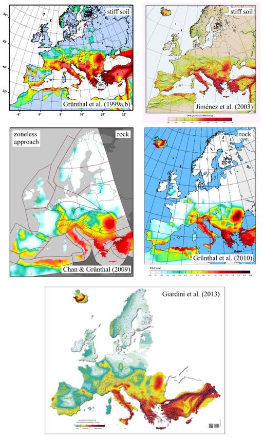
Workshop: Results of the European Project
SHARE: Seismic Hazard Harmonization in Europe
introduced by the state construction supervision agency in July 1988, recommended
to be used immediately. It became formally binding in July 1989 [8]. After the re-
unification of Germany the seismic zoning map of DIN 4149 in the version of 1981
was extended to the new Länder in 1991 by the first author and introduced as DIN
4149, version December 1992 [9].
This contribution represents the invited reporting on the state of the art of the German
building-code related seismic hazard analyses in the frame of a joint workshop 1 of
DGEB, OGE and SGEB. The contribution gives (1) a brief overview on the
seismicity of the country and its surroundings and provides (2) several features of
the currently still used seismic zoning approach for the National Application
Document of the Eurocode 8 from the mid-1990s. Further on, (3) the probabilistic
assessment of seismic loads for the current code for hydraulic structures is
characterized and (4) harmonized European seismic hazard assessments are
summarized. Furthermore, (5) previous seismic hazard maps are compared with the
recently published results of the SHARE project and seismic zoning maps of
neighbouring countries. Finally, (6) some innovations within the frame of the project
on the new generation of a national probabilistic seismic hazard assessment are
highlighted.
2 Seismicity of Germany and surroundings
The seismicity of a study area is the fundamental basis for respective seismic hazard
analyses. The seismicity of Germany; i.e., the area-related frequency and magnitudes
of tectonic earthquakes, can be regarded, in an European context, as medium to low.
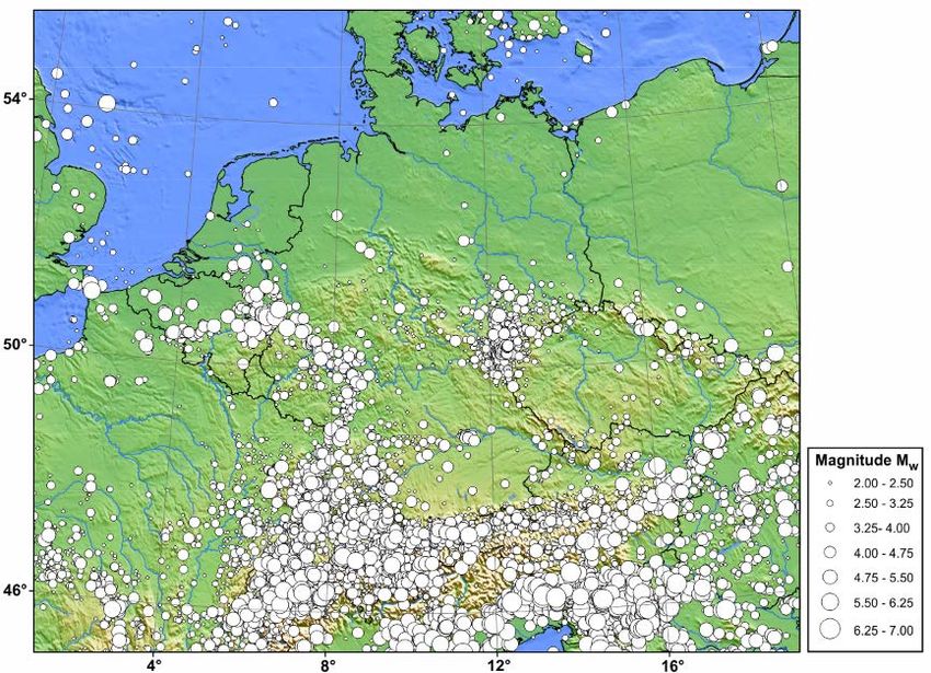
Fig. 1 shows the catalogued seismicity of Germany and its wider surroundings
according to the database of the European-Mediterranean earthquake catalogue
EMEC [10], which is the first long-term pan-European catalogue harmonized in
moment magnitudes Mw. A wider zone around Germany as target region needs to be
considered for PSHA, since seismic hazard assessments require an area of 200 to
300 km beyond the study area itself. In the presented map section the seismicity is
largest in the northernmost Apennines, in the Friuli area and the adjacent Dinarides.
It is fairly large as well in the western and central Alps. The remarkable seismicity
of the Mur-Mürz-Zilina shear zone in eastern Austria and adjacent parts of Slovakia
marks the tectonically active prolongation of the Alpine chain towards the
Carpathians.
North of the Alpine chain the seismicity is largest along the river Rhine and at the
eastern and western flanks of the southern Upper Rhine Graben. The most prominent
seismic source area since 1911 in Germany is that of the Hohenzollernalb, where a
1
Workshop „Presentation and Discussion of the Collaborative European Project SHARE
“Seismic Harmonization in Europe”, Frankfurt/Main Airport, May 27, 2014.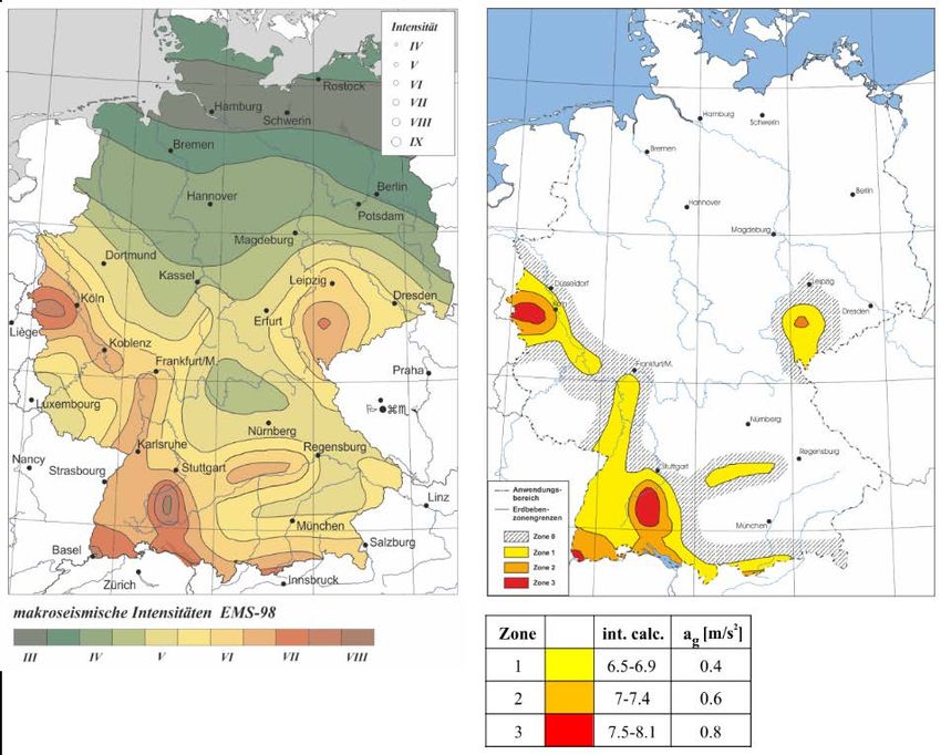
Workshop: Results of the European Project
                                   SHARE: Seismic Hazard Harmonization in Europe

Figure 1. Catalogued natural tectonic seismicity of Germany and its wider surroundings
according to the database of the European-Mediterranean earthquake catalogue EMEC [10].

still ongoing seismic sequence started with an Mw 5.7 earthquake on November 16,
1911. Other seismic epicentres concentrate on the region between the rivers Altmühl
and Donau, as well as in a zone covering Western Thuringia, eastern Saxony and the
adjacent areas of Bohemia and Bavaria. In this Saxothuringian seismotectonic
province damaging earthquakes with macroseismic intensities larger than 7 of the
EMS-98 [11] (or Mw = 5) are lacking in historical times.
Mw 6 earthquakes occurred in the immediate surroundings of Germany in 1692 (Mw
6.1), in eastern Belgium and in 1356 (Mw 6.6) immediately south of Basel,
Switzerland. According to [12, 13] an Mw 6.4 earthquake occurred in 1117 directly
SSE of the focal zone of the above mentioned Hohenzollernalb. An earthquake with
this magnitude would be even stronger than the disastrous northeast Italian Friuli
earthquake on May 6, 1976 with Mw 6.3, which was felt, e.g. in northerly direction,
as far as the Baltic Sea. Generally, no area of Germany can be regarded as aseismic;
i.e. where no earthquakes can be expected.

3    Seismic zoning map of the current German building code DIN 4149,
     respectively DIN EN 1998-1/NA
The introduction of a PSHA-based seismic zoning map became overdue in the early
1990s. A respective research proposal for the calculation of a PSHA map in terms of
peak ground acceleration (PGA) was submitted by the first author in 1992. In 1993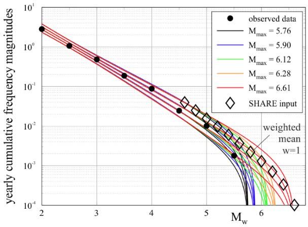
Workshop: Results of the European Project
                                      SHARE: Seismic Hazard Harmonization in Europe

Figure 2. Intensity based seismic hazard map [14] for a 10% exceedence probability within 50
years (left) and the corresponding seismic zoning map of the DIN 4149, resp. DIN EN 1998-1 with
the seismic zones 0 and 1-3.

a respective research project for an intensity-based PSHA was approved. It was
completed in July 1995 2. The results were delivered to the related national
committee of standards. After a verification procedure, the hazard map was accepted
by the committee of standards and the respective report [14] was released.
For the intensity-based PSHA a procedure was developed which fully made use of
intensity based steps of the processing. The prerequisite for this procedure is a
seismicity data base which is harmonized in terms of macroseismic intensity, where
the European Macroseismic Scale EMS-92 [15], i.e. the test version of the EMS-98
[11], has served very well.
The delineation of seismic source zones was conducted with feedback by L. Ahorner
(Bensberg) and G. Schneider (Stuttgart). The seismic source zones of the focal areas
in the Alpine region south of Germany were defined together with D. Mayer-Rosa
(Switzerland) [16]; later also with W. Lenhardt (Austria), published as an extension
of the German map for the D-A-CH countries Germany, Austria and Switzerland

2
 A respective seismic hazard map according to this PSHA project was first published on
July 25, 1995 in the Frankfurter Allgemeine Zeitung, followed by a number of other
newspapers.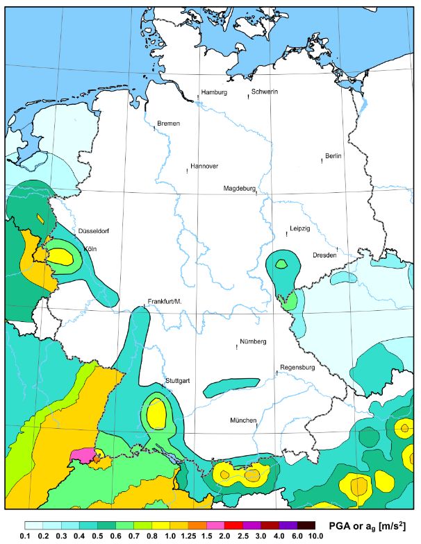
Workshop: Results of the European Project
                                           SHARE: Seismic Hazard Harmonization in Europe

[17]. It also served as the test case for the European part of the project GSHAP (cf.
chapter 5).
For each source zone the parameters of cumulative frequency intensity rates were
determined. The upper bound earthquakes have been defined in terms of intensities
as well. The intensity-based ground motion prediction relation by Sponheuer [18]
was applied; i.e. all steps of the procedure are based on the same parameter without
the need to apply empirical conversions between earthquake strength parameters.
The validation of the resulting seismic hazard map was carried out according to
historically observed macroseismic intensities. Admittedly, an intensity based PSHA
map implies that it is old-fashioned from today’s perspective, but at least for
validation purposes it still has its justification.
The definition of seismic zones was introduced by the committee of standards, where
the recommendation of the authors of the hazard map [14] was adopted. Fig. 2 shows
the hazard map and the corresponding zoning map [19, 20].
The difficulty in the applied approach concerns the assignment of acceleration based
parameter from intensity; i.e. the effective acceleration ag, as required at that time by
the respective version of the Eurocode 8 (EC8) [21] for the National Application
Document (NAD) and the respective design spectra. This part of the procedure
towards the definition of seismic loads for the seismic zones was not part of the
PSHA project, but was provided with respect to the design spectra in the frame of
independent research projects [22, 23].
Effective accelerations ag of 0.4 m/s2, 0.6 m/s2 and 0.8 m/s2 (cf. [24, 25]) were
associated to the seismic zone 1, 2 and 3. A comparison of the values of ag for the
calculated intensity ranges of the three seismic zones with empirical relations
between intensities and PGA [26-28] are given in Table 1, both for mean PGA and
their standard deviations ±1σ. The PGA ranges for the calculated intensities are,
according to Table 1, not unexpectedly, higher than the values of ag.

      Table 1. Relation between intensity, effective acceleration ag and peak ground
                               acceleration PGA in m/s2

Seismic zones: DIN 4149,      Faenza & Michelini       Faccioli & Cauzzi         Wald et al.
   DIN EN 1998-1/NA                  [28]                     [27]                 [26]

 Zone    Intensity,    ag    PGA mean        PGA       PGA         PGA        PGA        PGA
         calculated   m/s2   for 6.5-6.9     ±1σ       mean        ±1σ        mean       ±1σ
                                 etc.

  1       6.5-6.9     0.4    0.74-1.06     0.54-1.44 0.95-1.53   0.34-4.34   1.69-2.18 0.86-4.30

  2        7-7.4      0.6    1.15-1.65     0.84-2.25 1.72-2.75   0.60-7.81   2.32-2.99 1.18-5.90

  3       7.5-8.1     0.8    1.80-3.09     1.39-4.21 3.09-6.25 1.09-17.78 3.18-4.64 1.61-9.16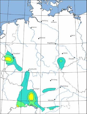
Workshop: Results of the European Project
                                        SHARE: Seismic Hazard Harmonization in Europe

A respective web-service provides the association of any settlement in Germany; i.e.
towns and villages, to a corresponding seismic zone [Web-1]. This performance uses
the calculated shapes of seismic zones. It operates since 04/2005 and has numerous
users daily since its implementation.

4    The seismic hazard results for the use of the safety regulations of hydraulic
     structures DIN 19700
A much more advanced PSHA approach in relation to the described intensity-based
procedure is the acceleration based 2006 version [29]. On behalf of the Ministry of
the Environment Baden-Württemberg the 2006 earthquake model was applied for
the needs of the safety regulation of hydraulic structures DIN 19700 [30]. Hazard
results in terms of maps and uniform hazard response spectra (UHS) were derived
for the mean return periods T = 100, 500, 1000 and 2500 years [31]. Related UHS

Figure 3. Illustration of the good coincidence of the calculated uniform hazard spectra (UHS)
according to [Web-2] with the related design spectra of DIN 4149 (resp. DIN EN 1998-1), when
the ag-value of the respective design spectrum is calibrated to the calculated PGA value (at 50 Hz)
of the UHS. On the one hand rock conditions are assumed for the site and on the other hand, for
better comparison, soil conditions.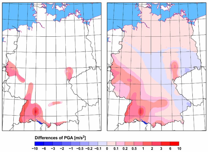
Workshop: Results of the European Project
                                   SHARE: Seismic Hazard Harmonization in Europe

for rock or soil are provided via the respective web-service [Web-2] for any location
not only in Baden-Württemberg but, as agreed, for any site in entire Germany as
well. This web-service is in operation since 11/2007 and frequently used not only for
the purpose of dam construction.
The approach extensively considers both aleatory and epistemic uncertainties of
input parameters and models used in the procedure. The resulting UHS coincide
surprisingly well with the DIN 4149 design spectra for different subsoil conditions
when calibrated to the same PGA, which is exemplarily illustrated in Fig. 3 for the
location Breisach. For details see the respective report [31]. Further below; i.e. in
chapter 6, the PGA hazard map (mean value, for the underground conditions of rock)
and UHS are compared with other hazard maps as subject of this paper.

5    Harmonized European seismic hazard models and hazard maps
An essential requirement of a Europe-wide PSHA is to achieve a cross-bordering
harmonization in preferably all steps of the procedure. The first project to carry out
such a goal was the Global Seismic Hazard Assessment Program (GSHAP) in the
frame of the United Nations International Decade on Natural Disaster Reduction
(IDNDR). GSHAP was implemented in the period from 1992 to 1999. In total, more
than 500 experts were actively involved in this undertaking [32]. The GFZ Potsdam
was selected as the European seismic hazard competence centre and Regional Centre
of the GSHAP Region 3 [33]. A first version of the calculated harmonized seismic
hazard map for GSHAP region 3 was already presented in 1996 [34]. In the final
stage of GSHAP, the GFZ Potsdam became responsible for the Mediterranean region
as well; i.e. GSHAP region 4. The map for GSHAP region 4 was basically generated
by harmonizing latest versions of national maps, where available [35]. The final
hazard map of both regions [33, 35] is part of Fig. 4. After finishing the project, the
harmonized earthquake catalogue for GSHAP region 3; i.e. Europe north of 44°N,
was published [36], which was later updated as the harmonized database CENEC
[37] and checked with respect to the level of harmonization, which could be achieved
[38].
The SESAME hazard map [39] as another example of a European-wide harmonized
PSHA is north of 44°N; i.e. in the area of the GSHAP region 3, identical with the
results by GSHAP [33], while further south the differences are in general minor
except for the area of Greece and Turkey. The SESAME hazard map is shown in
Fig. 4 as the upper right map.
In the frame of the EC project NERIES [Web-3] a harmonized seismic hazard map
was calculated [40] as basis map for the “living European seismic hazard map” [41]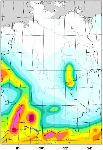
Workshop: Results of the European Project
                                       SHARE: Seismic Hazard Harmonization in Europe

Figure 4. Harmonized European-Mediterranean PSHA maps, all in PGA for 10% exceedence
probability in 50 years. Upper left: GSHAP [33-35], upper right: SESAME [39] both for stiff soil.
Middle left: EC project NERIES [40]. Middle right: GEM1 [42]. Below: EC project SHARE
[Web-5]. The three lower ones for rock.

to show short-term time-dependent seismic hazard modulating the basis map. The
basis map (in Fig. 4 as the map in the middle on the left) was developed as an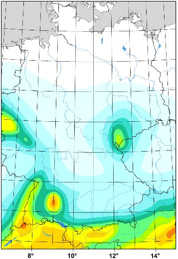
Workshop: Results of the European Project
                                  SHARE: Seismic Hazard Harmonization in Europe

innovative hybrid zoneless approach to allow easy updates, when new seismicity
pattern have occurred. The harmonized European-Mediterranean earthquake
catalogue EMEC [10], in its early stage, could be applied for this project.
Another harmonized Euro-Mediterranean seismic hazard map [42], shown in the
middle part of Fig. 4 on the right, was computed in the frame of the test phase of the
Global Earthquake Modeling Project GEM1 [Web-4]. This PSHA approach makes
use of the harmonized seismic source zone model of SESAME [39].
The so far last and most elaborated harmonized European seismic hazard map is the
one produced in the frame of the EU-FP7 project SHARE “Seismic hazard
harmonization in Europe” [Web-5] with many innovations and a large number of
experts involved. The here discussed PGA hazard map as one of the results of
SHARE is shown in Fig. 4, lower part. The final SHARE results were produced a
couple of months after the cost neutral prolongation of the project until November
2012. From the engineering point of view, the most important results of SHARE are
not the different hazard maps, but the UHS, similar to the German project with
respect to the calculation of the seismic loads for the DIN 19700 [Web-2]. UHS for
rock site conditions as result of SHARE [Web-6] are dealt with in the next chapter.

6    Comparison of seismic hazard results
The hazard results of the ag based seismic zoning map of the DIN 4149, resp. DIN
EN 1998-1/NA [19, 20] are compared with the PGA map derived in the frame of the
project to develop seismic loads for the DIN 19700 [31] and with the SHARE PGA
map for Germany, using the same colour code for the three maps (Fig. 5). A better
quantitative interpretation of the comparison is possible with difference maps
between both national maps and the SHARE map excerpted for Germany (Fig. 6).
Large differences between the national maps and the SHARE map are striking, but
one has to consider that the DIN 4149 zoning map shows ag and not PGA as the other
two maps.
As said before, the site specific UHS are more important than the PGA maps. A
respective comparison can be made between the UHS of SHARE (solely for rock
site conditions) with those derived for the usage of the DIN 19700 [31] shown in
Fig. 7 exemplarily for the city of Aachen for three hazard levels in terms of mean
return periods T. The SHARE response spectra show higher spectral amplitudes by
a factor of about 1.8. Although the values of T are not identical according to both
projects (e.g. T = 475 and T = 500 years), the corresponding differences in the
respective spectra can be regarded as minor.
A comparison of hazard maps is also interesting with respect to national seismic
zoning or seismic hazard maps of the neighbouring countries. Fig. 8 shows the
respective parts of maps of Germany’s neighbouring countries. These are the maps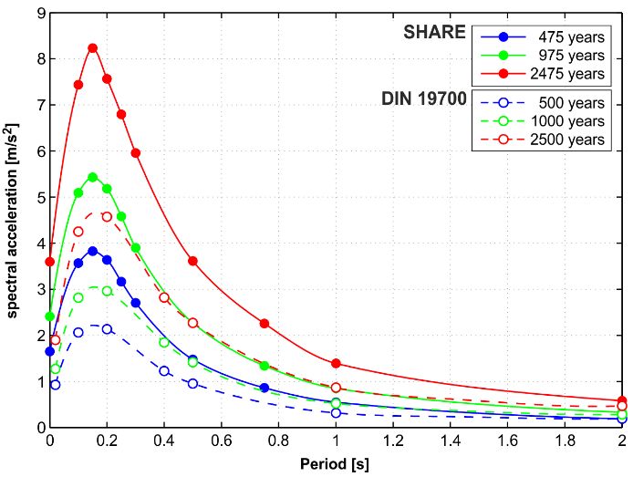
Workshop: Results of the European Project
                                      SHARE: Seismic Hazard Harmonization in Europe

                                                          rock                           rock

Figure 5. Comparison (from left to right) of the seismic zoning map of the DIN 4149 [19, 20] in
effective acceleration ag with the PGA seismic hazard maps of the DIN 19700 [31] and the PGA
SHARE map [Web-5]. The maps are given for the standard hazard level of building codes; i.e.
for 10% exceedence probability within 50 years corresponding to the mean return period T = 475
years – except the middle map of the DIN 19700 which is required for T = 500 years. All maps
are in the same colour code.

Figure 6. Differences of both national maps of Fig. 5 with the SHARE PGA for Germany. Left:
SHARE PGA minus ag of DIN 4149 seismic zoning. Right: the same as for the DIN 19700 PGA.
Workshop: Results of the European Project
SHARE: Seismic Hazard Harmonization in Europe
Figure 7. Comparison of uniform hazard spectra available for the usage of the DIN 19700
(www.gfz-potsdam.de/DIN19700, [Web-2]) with those according to SHARE (http://www.share-
eu.org/, [Web-6]) given here as an example for the city of Aachen for rock subsoil conditions for
three mean return periods.
Figure 8. Comparison of the German seismic zoning map with those of the neighbouring
countries. For references see text.Workshop: Results of the European Project
SHARE: Seismic Hazard Harmonization in Europe
of the Czech Republic [43], Austria [44, 45], Switzerland [46], France [Web-7],
Belgium [47] and the Netherlands [48]. For Germany itself we here use the ag map
of the DIN 4149, resp. DIN EN 1998-1/NA [19, 20]. The acceleration values of
different national maps are, where needed, rounded to one decimal. In case of given
ranges of PGA or ag, particularly for Austria, the respective lower margins are used
for display. The coincidence of the German ag-values is quite good with the national
values of the Czech Republic, when considering the fact that the German map omits
values below 0.4 m/s2. The general accordance with the Austrian and Swiss data is
also good, except of the area of Tyrol (Austria) and the area of Basel (Switzerland)
with somewhat higher values. On the other hand, the acceleration values of French
and Belgian maps are distinctly higher. The Dutch map again shows a somewhat
better accordance.
Figure 9. Seismicity rates for the seismic source zone Hohenzollernalb for the five calculated
discretized Mmax from the respective probability density of M max determined for this source zone.
To account for the uncertainty of the seismicity rates, four respective sets with different weights
are considered for each discretized value of M max, which yields altogether twenty curves of
seismicity rates per source zone. A comparison is given for this source zone with the one set of
rates in 0.2 magnitude bins used in SHARE. The input for the new national approach will use a
minimum magnitude for the hazard calculations in the range of 4.0-4.5 and also in 0.05 magnitude
bins.
7 Post-SHARE seismic hazard approaches
In a document of the SHARE-EC8 Workshop on November 28, 2013 [49] it is
concluded that “All countries in Europe are thus encouraged to carry out an
evaluation … of hazard results … by comparing SHARE results with those based on
national source models with the SHARE GMPE 3 logic tree.” A number of respective
national projects were launched in the meanwhile; e.g. in Switzerland (personal
communication Stefan Wiemer, May 2012) or in Italy [50].
3
GMPE: ground motion prediction equationWorkshop: Results of the European Project
SHARE: Seismic Hazard Harmonization in Europe
In Germany, a respective research proposal was submitted in 2011 and approved in
2013. In the frame of this approach aleatory and epistemic uncertainties are
considered in a comprehensive way. The minimum moment magnitude Mw
considered for the determination of e.g. seismicity rates is Mw ≥ 2 or even smaller,
while in contrary the Mw min within SHARE was 3.5 in Europe north of 44°N. The
higher threshold value can involve limitations in handling low seismicity areas.
Among the innovations being used for this new national project is an improved way
to implement seismicity rates of seismic source zones with their uncertainties, which
is illustrated in Fig. 9 for a particular seismic source zone. For comparison, the
respective SHARE seismicity rates are given for this source zone. An essential step
of the national approach will also be to achieve a harmonization with respective
activities in neighbouring countries.
8 Conclusions
In brief, the conclusions of this contribution can be summarized as follows:
• The current version of seismic zoning does not meet the needs of current
code requirements.
• The 2006/2009 version of PSHA applied for requirements of DIN 19700
represents an already advanced stage of research.
• Harmonized European seismic zoning maps exists, the SHARE project
being the last and most elaborated one.
• The SHARE PGA for Germany differ considerably from results of previous
zoning or hazard maps in areas of highest seismicity within the country.
• Post-SHARE activities in PSHA exist in different countries, also in
Germany.
• The next version of German seismic zoning will be based on distinct
innovations; harmonization with neighbouring countries is aspired.
Acknowledgment
The authors are thankful for information provided by Jochen Schwarz (Weimar) and
Fabrice Cotton (Grenoble/Potsdam).Workshop: Results of the European Project
SHARE: Seismic Hazard Harmonization in Europe
REFERENCES
[1] Zum Entwurf der DIN 4149 “Bauten in Erdbebengebieten, Richtlinien für
die Ausführung“; Die Bautechnik; 5 (1955), 161
[2] Sieberg, A.: Beiträge zum Erdbebenkatalog Deutschlands und angrenzender
Gebiete für die Jahre 58-1799, Mitteilungen des Deutschen Reichs-
Erdbebendienstes 2; Berlin, Reichsverlagsamt Berlin, (1940), 112 p.
[3] Bauten in deutschen Erdbebengebieten. Richtlinien für Bemessung und
Ausführung, DIN 4149 Entwurf März 1955; Die Bautechnik; 5 (1955), 161-
164
[4] Bauten in deutschen Erdbebengebieten. Richtlinien für Bemessung und
Ausführung, DIN 4149 Juli 1957 (1957), Normblatt DK 624.042.7:351.78
[5] Bauten in deutschen Erdbebengebieten. Lastannahmen, Bemessung und
Ausführung üblicher Hochbauten, DIN 4149, Teil 1, April 1981 (1981),
Normblatt DK 699.841:550.34(430)(084.3):624.9.042.7
[6] Ahorner, L., Murawski, H., Schneider, G.: Die Verbreitung von
schadenverursachenden Erdbeben auf dem Gebiet der Bundesrepublik
Deutschland. Versuch einer seismologischen Regionalisierung; Zeitschrift
für Geophysik; 36 (1970), 313-3643
[7] Grünthal, G.: Die seismische Gefährdung im östlichen Teil Deutschlands
und deren Berücksichtigung in erdbebengerechten Baunormen; in:
Erdbebeningenieurwesen: Ingenieurseismologische Grundlagen,
Vorschriften und Standards, Fallstudien. Vortragsband des 4. Kolloquiums
Erdbebeningenieurwesen und Baudynamik, Knoll, P., Werner, D. (eds.),
DGEB-Publikation 5, Potsdam, Zentralinstitut für Physik der Erde (1991),
pp. 9-38
[8] Bauwerke unter Erdbebeneinwirkung, Vorschrift 208/88, Staatliche
Bauaufsicht (1988), pp. 57-72, 8-9
[9] DIN 4149 Teil 1 A1. Bauten in deutschen Erdbebengebieten. Lastannahmen,
Bemessung und Ausführung üblicher Hochbauten. Änderung 1, Karte der
Erdbebenzonen, Dezember 1992 (1992), Normblatt
DK699.841:550.34(430)(084.3):624.9.042.7, Änderung von DIN 4149 Teil
1/04.81
[10] Grünthal, G., Wahlström, R.: The European-Mediterranean Earthquake
Catalogue (EMEC) for the last millennium; Journal of Seismology; 16
(2012), 535-570 (doi: 10.1007/s10950-012-9302-y, http://www.gfz-
potsdam.de/EMEC)Workshop: Results of the European Project
SHARE: Seismic Hazard Harmonization in Europe
[11] Grünthal, G. (ed.), Musson, R. M. W., Schwarz, J., Stucchi, M. (assoc. eds.):
European Macroseismic Scale 1998 (EMS-98), Cahiers du Centre Européen
de Géodynamique et de Séismologie, Volume 15; Luxembourg, Centre
Européen de Géodynamique et de Séismologie (1998), 99 p.
[12] Guidoboni, E., Comastri, A., Boschi, E.: The “exceptional” earthquake of 3
January 1117 in the Verona area (northern Italy): A critical time review and
detection of two lost earthquakes (lower Germany and Tuscany); Journal of
Geophysical Research; 110 (2005), B12309 (doi: 10.1029/2005JB003683)
[13] Leydecker, G.: Erdbebenkatalog für Deutschland mit Randgebieten für die
Jahre 800 bis 2008; Geologisches Jahrbuch, Reihe E; Heft 59 (2011)
[14] Grünthal, G., Bosse, Ch.: Probabilistische Karte der Erdbebengefährdung der
Bundesrepublik Deutschland - Erdbebenzonierungskarte für das Nationale
Anwendungsdokument zum Eurocode 8: Forschungsbericht, Scientific
Technical Report 96/10; Potsdam, GeoForschungsZentrum Potsdam, (1996),
24 p.
[15] Grünthal, G. (ed.), Musson, R. M. W., Schwarz, J., Stucchi, M. (assoc. eds.):
The European Macroseismic Scale 1992: (up-dated MSK-scale), Cahiers du
Centre Européen de Géodynamique et de Séismologie, Volume 7;
Luxembourg, Centre Européen de Géodynamique et de Séismologie (1993),
79 p.
[16] Grünthal, G., Mayer-Rosa, D.: Einheitliche Erdbebengefährdungskarte für
Deutschland, Österreich und die Schweiz (D-A-CH). Carte de l’ aléa
sismique unifiée pour l‘Allemagne, l‘Autriche et la Suisse (D-A-CH); in:
Schweizerischer Pool für Erdbebendeckung, Geschäftsbericht 1997, Bern
(1998), pp. 11-24
[17] Grünthal, G., Mayer-Rosa, D., Lenhardt, W.: Abschätzung der
Erdbebengefährdung für die D-A-CH-Staaten - Deutschland, Österreich,
Schweiz; Bautechnik; 75 (1998), 753-767
[18] Sponheuer, W.: Methoden zur Herdtiefenbestimmung in der Makroseismik;
Freiberger Forschungsheft C88 (1960)
[19] DIN 4149:2005-04, Bauten in deutschen Erdbebengebieten - Lastannahmen,
Bemessung und Ausführung üblicher Hochbauten, April 2005 (2005)
[20] DIN EN 1998-1/NA 2011-01. Nationaler Anhang - National festgelegte
Parameter - Eurocode 8: Auslegung von Bauwerken gegen Erdbeben - Teil
1: Grundlagen, Erdbebeneinwirkungen und Regeln für Hochbau, Januar
2011, DIN Deutsches Institut für Normung e. V., (2011), 31 p.Workshop: Results of the European Project
SHARE: Seismic Hazard Harmonization in Europe
[21] ENV 1998-1-1: Eurocode 8 - Design provisions for earthquake resistance of
structures. Part 1-1: General rules - Seismic actions and general requirements
for structures, October 1994, CEN, (1994)
[22] Brüstle, W., Stange, S.: Geologische Untergrundklassen zum Entwurf von
Normspektren für DIN 4149 (neu) - Vorstudie zum Forschungsvorhaben
„Karte der geologischen Untergrundklassen für DIN 4149 (neu)“:
Modellrechnungen mit Programm SIMUL für synthetische Tiefenprofile der
Scherschwellengeschwindigkeit zur Klassifizierung des Untergrundes in
deutschen Erdbebengebieten (Stand Juli 1999), Berichtsnummer 3480.01/98-
4764; Freiburg i. Br./Germany, Landesamt für Geologie, Rohstoffe und
Bergbau Baden-Württemberg, (1999), 33 p.
[23] Schwarz, J., Lang, D., Golbs, Ch.: Erarbeitung von Spektren für die DIN
4149-neu unter Berücksichtigung der Besonderheiten deutscher
Erdbebengebiete und der Periodenlage von Mauerwerksbauten.
Forschungsbericht im Auftrage der Deutschen Gesellschaft für
Mauerwerksbau e. V., Erdbebenzentrum am Institut für Konstruktiven
Ingenieurbau der Bauhaus-Universität Weimar, Juli 1999 (1. Entwurf),
September 1999 (Endfassung), (1999)
[24] Schwarz, J.: Evaluation of effective accelerations for Eurocode 8; in:
Seismology in Europe, Thorkelsson, B. (ed.), Papers presented at the 25th
General Assembly of the European Seismological Commission (Reykjavik
1996), Reykjavik, Icelandic Meteorological Office, Ministry for the
Environment, University of Iceland (1996), pp. 648-654
[25] Schwarz, J.: Festlegung effektiver Beschleunigungen für seismische
Gefährdungszonen im Zusammenhang mit der nationalen Anwendung des
EC8. Forschungsprojekt IV 1-5-781/95 im Auftrage des Deutschen Insituts
für Bautechnik Berlin; Weimar, Bauhaus-Universität Institut für
Konstruktiven Ingenieurbau, (1997)
[26] Wald, D. F., Quitoriano, V., Heaton, T. H., Kanamori, H., Scrivner, C.W.,
Worden, C. B.: TriNet “shake maps”: rapid generation of peak ground
motion and intensity maps for earthquake in southern California; Earthquake
Spectra; 15 (1999), 537-556
[27] Faccioli, E., Cauzzi, C.: Macroseismic intensities for seismic scenarios,
estimated from instrumentally based correlations; in: Abstract Book 1st
ECEES (2006), p. 125
[28] Faenza, L., Michelini, A.: Regression analysis of MCS intensity and ground
motion parameters in Italy and its application in ShakeMap; Geophysical
Journal International; 180 (2010), 1138-1152Workshop: Results of the European Project
SHARE: Seismic Hazard Harmonization in Europe
[29] Grünthal, G., Bosse, C., Stromeyer, D., Wahlström, R.: New Generation of
Probabilistic Seismic Hazard Assessment of Germany; 1st European
Conference on Earthquake Engineering and Seismology
(Geneva/Switzerland); Abstract Book, SC-FO Engineering Seismology;
(2006), p. 462
[30] DIN 19700. Wasserbau 1. Stauanlagen, Stahlwasserbau,
Wasserkraftanlagen, Wasserbauwerke, Schöpfwerke, DIN-Taschenbuch
179; Berlin, Beuth-Verlag, (2014), 600 p.
[31] Grünthal, G., Bosse, C., Stromeyer, D.: Die neue Generation der
probabilistischen seismischen Gefährdungseinschätzung der Bundesrepublik
Deutschland: Version 2007 mit Anwendung für die Erdbeben-Lastfälle der
DIN 19700:2004-07 ‚Stauanlagen‘, Scientific Technical Report STR 09/07;
Potsdam, Deutsches GeoForschungsZentrum, (2009), 81 p.
(http://dx.doi.org/10.2312/GFZ.b103-09076)
[32] Giardini, D., Grünthal, G., Shedlock, K. M., Zhang, P.: The GSHAP Global
Seismic Hazard Map; Annali di Geofisica; 42 (1999), 1225-1230
[33] Grünthal, G., , GSHAP Region 3 Working Group, Bosse, C., Camelbeeck,
T., de Crook, Th., Gariel, J.- Ch., Gregersen, S., Guterch, B., Halldorsson,
P., Labák, P., Lindholm, C., Lenhardt, W., Mäntyniemyi, P., Mayer-Rosa,
D., Musson, R. M. W., Schenk, V., Schenková, Z., Slejko, D., Verbeiren, R.,
Wahlström, R., Zabukovec, B., Zíros, T.: Seismic hazard assessment for
central, north and northwest Europe: GSHAP Region 3; Annali di Geofisica;
42 (1999), 999-1011
[34] Grünthal, G., Bosse, Ch., Musson, R. M. W., Gariel, J.- Ch., de Crook, Th.,
Verbeiren, R., Camelbeeck, T., Mayer-Rosa, D., Lenhardt, W.: Joint seismic
hazard assessment for the central and western part of GSHAP-Region 3
(Central and Northwest Europe); in: Seismology in Europe, Thorkelsson, B.
(ed.), Papers presented at the 25th General Assembly of the European
Seismological Commission (Reykjavik 1996), Reykjavik, Icelandic
Meteorological Office, Ministry for the Environment, University of Iceland
(1996), pp. 339-342
[35] Grünthal, G., Bosse, Ch., Sellami, S., Mayer-Rosa, D., Giardini, D.:
Compilation of the GSHAP regional seismic hazard for Europe, Africa and
the Middle East; Annali di Geofisica; 42 (1999), 1215-1223
[36] Grünthal, G., Wahlström, R.: An Mw based earthquake catalogue for central,
northern and northwestern Europe using a hierarchy of magnitude
conversions; Journal of Seismology; 7 (2003), 507-531
[37] Grünthal, G., Wahlström, R., Stromeyer, D.: The unified catalogue of
earthquakes in central, northern, and northwestern Europe (CENEC) -Workshop: Results of the European Project
SHARE: Seismic Hazard Harmonization in Europe
updated and expanded to the last millennium; Journal of Seismology; 13
(2009), 517-541 (doi: 10.1007/s10950-008-9144-9,
http://dx.doi.org/10.2312/GFZ.CENEC-2008)
[38] Grünthal, G., Wahlström, R., Stromeyer, D.: Harmonization check of Mw
within the central, northern, and northwestern European earthquake
catalogue (CENEC); Journal of Seismology; 13 (2009), 613-632 (doi:
10.1007/s10950-009-9154-2)
[39] Jiménez, M.-J., Giardini, D., Grünthal, G.: The ESC-SESAME unified
hazard model for the European-Mediterranean region; EMSC/CSEM
Newsletter; 19 (2003), 2-4
[40] Chan, C.-H., Grünthal, G.: Hybrid zoneless probabilistic seismic hazard
assessment: Test and first application to Europe and the Mediterranean, Final
report, Network of Research Infrastructures for European Seismology
NERIES, Subproject JRA2 “Real time hazard tools” Task A “The living
Euro-Med earthquake hazard”, (2010), 23 p. (www.neries-
eu.org/main.pfp/JRA2_D8.pdf)
[41] Woessner, J., Kaestli, P.: Living European hazard map and portal.
Deliverable 5, Final report, Network of Research Infrastructures for
European Seismology NERIES, Subproject JRA2 “Real time hazard tools”,
(2010), 23 p. (www.neries-eu.org/main.pfp/JRA2_D5.pdf)
[42] Grünthal, G., Arvidsson, R., Bosse, C.: Earthquake Model for the European-
Mediterranean Region for the Purpose of GEM1; ed. by Geosciences, GFZ
German Research Centre for, Scientific Technical Report 10/04; Potsdam,
GFZ German Research Centre for Geosciences, (2010), 38 p.
(http://dx.doi.org/10.2312/GFZ.b103-10043)
[43] Schenk, V., Schenková, Z.: B.3 Geological environment and soil. Seismic
areas in CR-CSN P ENV 1998-1-1. National application document -
Eurocode 8, The Ministry of Environment of the Czech Republic, Statistical
environmental yearbook of the Czech Republic, Prague/Czech Republic
(2003), pp. 227-231, 245
[44] ÖNORM EN 1998-1:2011-06-15. Eurocode 8: Auslegung von Bauwerken
gegen Erdbeben - Teil 1: Grundlagen, Erdbebeneinwirkungen und Regeln
für Hochbauten (2011)
[45] ÖNORM EN 1998-1:2011-06-15. Eurocode 8: Auslegung von Bauwerken
gegen Erdbeben - Teil 1: Grundlagen, Erdbebeneinwirkungen und Regeln
für Hochbauten, nationale Festlegungen zu ÖNORM EN 1998-1 und
nationale Erläuterungen (2011)
[46] Norm SIA 261: Einwirkungen auf Tragwerke, Edition 2003 Zürich,
Schweizer Ingenieur- und Architekten-Verein (2003)Workshop: Results of the European Project
SHARE: Seismic Hazard Harmonization in Europe
[47] Plumier, A., Doneux, C., Camelbeeck, T., van Rompaey, G., Jongmans, D.,
Wathelet, M., Teerlynck, H., Nguyen, F.: Seismic Risk Assessment and
Mitigation for Belgium in the frame of EUROCODE 8. Final Report, (2001),
73 p.
[48] de Crook, Th.: A seismic zoning map conforming to Eurocode 8, and
practical earthquake parameter relations for the Netherlands; Geologie en
Mijnbouw; 75 (1996), 11-18
[49] Discussion Points from SHARE EC8 Workshop, Ispra/Italy, November 28,
2013 (2013)
[50] GEM Newsletter, March 2014 (2014)
[Web-1] http://www.gfz-potsdam.de/DIN4149_Erdbebenzonenabfrage, publisher:
GFZ Potsdam [Accessed 28 August 2014]
[Web-2] http://www.gfz-potsdam.de/DIN19700, publisher: Deutsches
GeoForschungsZentrum Potsdam [Accessed 28 August 2014],
(http://dx.doi.org/10.5880/GFZ.2.6.2012.001).
[Web-3] http://www.neries-eu.org/, publisher: European Commission [Accessed
28 August 2014]
[Web-4] http://www.globalquakemodel.org/, publisher: GEM Foundation
[Accessed 28 August 2014]
[Web-5] http://www.share-eu.org/, publisher: Swiss Seismological Service
[Accessed 28 August 2014]
[Web-6] http://www.efehr.org:8080/jetspeed/portal/HazardSpectra.psml,
publisher: ETH Zürich [Accessed 28 August 2014]
[Web-7] http://www.planseisme.fr/Zonage-sismique-de-la-France.html, publisher:
Ministère de l’Ecologie, du Développement Durable et de l’Energie
[Accessed 28 August 2014]You can also read