INVESTIGATION INTO AN INCIDENT INVOLVING THE GROUNDING OF THE VESSEL - 'MV ALTA' AT BALLYANDREEN BAY, BALLYCOTTON, CO. CORK - Marine Casualty ...
←
→
Page content transcription
If your browser does not render page correctly, please read the page content below
INVESTIGATION INTO AN
 INCIDENT INVOLVING THE
GROUNDING OF THE VESSEL
       ‘MV ALTA’
 AT BALLYANDREEN BAY,
BALLYCOTTON, CO. CORK
   16 FEBRUARY 2020

 REPORT NO. MCIB/299
    (No.1 OF 2021)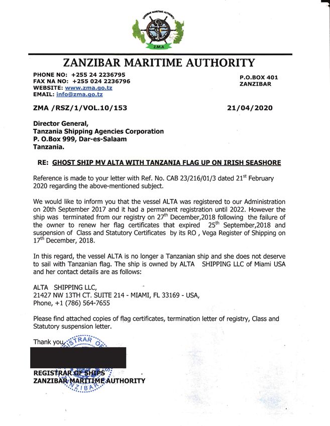
The Marine Casualty Investigation Board (MCIB) examines and investigates all types of marine
casualties to, or on board, Irish registered vessels worldwide and other vessels in Irish territorial
waters and inland waterways.

The MCIB objective in investigating a marine casualty is to determine its circumstances and its
causes with a view to making recommendations to the Minister of Transport - for the avoidance
of similar marine casualties in the future, thereby improving the safety of life at sea and inland
waterways.

The MCIB is a non-prosecutorial body. We do not enforce laws or carry out prosecutions. It is not
the purpose of an investigation carried out by the MCIB to apportion blame or fault.

The legislative framework for the operation of the MCIB, the reporting and investigating of
marine casualties and the powers of MCIB investigators is set out in the Merchant Shipping
(Investigation of Marine Casualties) Act, 2000.

In carrying out its functions the MCIB complies with the provisions of the International Maritime
Organisation’s Casualty Investigation Code and EU Directive 2009/18/EC governing the
investigation of accidents in the maritime transport sector.
Leeson Lane, Dublin 2.
Telephone: 01-678 3485/86.
    email: info@mcib.ie
         www.mcib.ie
                                        INVESTIGATION INTO AN
                                        INCIDENT INVOLVING THE
                                       GROUNDING OF THE VESSEL
                                              ‘MV ALTA’
                                        AT BALLYANDREEN BAY,
                                       BALLYCOTTON, CO. CORK
                                          16 FEBRUARY 2020

 The Marine Casualty Investigation
 Board was established on the
 25th March 2003 under the
 Merchant Shipping (Investigation
 of Marine Casualties) Act, 2000.

 The copyright in the enclosed
 report remains with the Marine
 Casualty Investigation Board by
 virtue of section 35(5) of the
 Merchant Shipping (Investigation
 of Marine Casualties) Act, 2000. No
 person may produce, reproduce or
 transmit in any form or by any
 means this report or any part
 thereof without the express             REPORT NO. MCIB/299
 permission of the Marine Casualty          (No.1 OF 2021)
 Investigation Board. This report
 may be freely used for educational
 purposes.
                                                                 1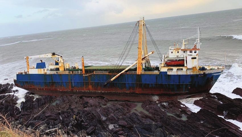
Glossary of Abbreviations and Acronyms

    AIS                Automatic Identification System
    CSR                Continuous Synopsis Record
    Cork CC            Cork County Council
    DAFM               Department of Agriculture Food and the Marine
    DoT                Department of Transport
    EEZ                Exclusive Economic Zone
    EMSA               European Maritime Safety Agency
    EPA                Environmental Protection Agency
    ETA                Estimated Time of Arrival
    EU                 European Union
    FMC                Fisheries Monitoring Centre
    GT                 Gross Tonnage*Note 1
    HMS                Her Majesty’s Ship
    IMA                Irish Maritime Administration
    IMO                International Maritime Organisation
    INS                Irish Naval Service
    IRCG               Irish Coast Guard
    ISM                International Safety Management
    LRIT               Long Range Identification and Tracking
    LOA                Length Overall
    MARPOL             International Convention for the Prevention of Pollution from Ships
    MCIB               Marine Casualty Investigation Board
    MoP                Member of the Public
    MRCC               Marine Rescue Coordination Centre
    MRSC               Marine Rescue Sub-Centre
    MSO                Marine Survey Office
    MSS                Maritime Support Service
    MV                 Motor Vessel
    RCC                Rescue Co-ordination Centre
    SFLA               Sea Fish Licensing Authority
    UK                 United Kingdom
    US                 United States
    USCG               United States Coast Guard
    WNWS               Worldwide Navigational Warning Service

    Kilometres         km
    Kilowatts          kW
    Litres             (lts)
    Metres             m
    Nautical miles     NM
    Tonnes             t
    *Note 1: Gross Tonnage is a nonlinear measure of a ship’s overall internal volume. In the regulations which
    govern the measurement of ships the ‘tonnage’ measurement is one of capacity, the unit of one ton being a
    capacity measurement of 100 feet cubed (ft 3). Gross Tonnage should not be confused with measures of
    mass or weight such as deadweight tonnage or displacement.
    Gross Tonnage is calculated based on “the moulded volume of all enclosed spaces of the ship” and is the
    total internal capacity of a ship measured from the top of the floors or ceiling to the tonnage deck including
    the fore and aft peak tanks above the floors. Gross Tonnage is used to determine issues such as a ship’s
    manning regulations, safety rules, registration fees and port dues.
    Gross tonnage is defined by the International Convention on Tonnage Measurement of Ships, 1969, adopted
    by the International Maritime Organization in 1969, and came into force on 18 July 1982.

2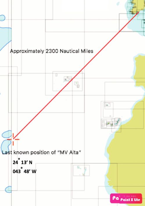
CONTENTS

                                                                           PAGE

1.   Summary                                                                  4

2.   Factual Information                                                      5

3.   Narrative                                                                7

4.   Analysis                                                                10

5.   Conclusions                                                             14

6.   Safety Recommendations                                                  15

7.   Appendices                                                              16

8.   MSA 2000 Section 36 - Correspondence Received                           24

 Report MCIB/299 published by the Marine Casualty Investigation Board.
 Produced 26th February 2021.

                                                                                  3
SUMMARY
1. SUMMARY
1.1 Motor Vessel ‘MV Alta’ is a merchant ship built in 1976. The crew were stranded
onboard after the ship was rendered irreparably disabled on a voyage from
Greece to Haiti. ‘MV Alta’ was abandoned by the crew and left adrift in October
2018 after a US Coast Guard relief operation rescued the crew of 10
approximately 1,400 miles south-east of Bermuda. On 3 September 2019, the UK’s
Royal Navy ‘HMS Protector’ sighted the ‘MV Alta’, derelict in the middle of the
Atlantic Ocean. The derelict drifted eastward and finally came ashore on 16
February 2020 in Ballyandreen Bay and grounded on the shore near Ballycotton,
County Cork, Ireland.
4FACTUAL INFORMATION
2. FACTUAL INFORMATION
2.1 Vessel Details:
Name of Vessel: ‘Alta’ (since 1 September 2017).
Port of Registry: None.
Type: General Cargo Ship (during 1976).
Launched: 1976.
Identification: IMO Number 7432305.
Gross Tonnage: 2295 Tonnes (t) (since 1 July 1994).
Length: 77.32 metres (m).
Deadweight: 1640 t capacity.
Flag: Tanzania (since 1 November 2017).
Status of Ship: Total Loss (since 19 September 2018).
Last Update: 25 February 2020.
See Appendix 7.1 Photograph No.1 - ‘MV Alta’ aground in Ballyandreen Bay,
Co. Cork.
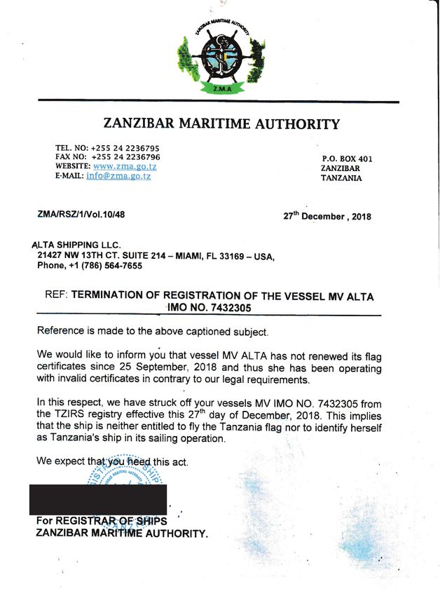
See Appendix 7.2 Details of Tanzania Vessel Registration.
2.2 Vessel History:
1976: Built and named ‘Tananger’.
Port of Registry: Bergen, Norway.
Owner: A/S Tananger.
February 1990: Renamed ‘Pomor Murman’.
Port of Registry: Tromso, Norway.
Owner: K/S Murman.
January 1994: Renamed ‘Polar Trader’.
Port of Registry: Tromso, Norway.
Owner: K/S Murman.
December 1996: Sold to Seakon Shipping A/S.
5FACTUAL INFORMATION Cont.
October 1997: Sold to Team Ship A/S.
November 1999: Reregistered.
Port of Registry: Valletta, Malta.
August 2000: Renamed ‘Avantis II’.
Port of Registry: Piraeus, Greece.
Owner: Nileys Maritime Corp.
February 2002: Renamed ‘Avantis I’.
Port of Registry: Athens, Greece.
Owner: Hiliadou Maritime - Chalkis, Greece.
November 2010: Renamed ‘Elias’.
Port of Registry: Panama.
Owner: BTG Shipping Corp.
November 2017: Renamed ‘Alta’.
Port of Registry: Zanzibar, Tanzania.
Owner: Alta Sg LLC.
December 2018: Ship was deleted from the ship register of Tanzania.
2.3 Intended Voyage Particulars:
Departure: Greece September 2018.
Intended arrival: Haiti 27 September 2018.
2.4 Type of Casualty:
The derelict vessel came ashore on the coast near Ballycotton, County Cork.
Injuries: There were no reported injuries to persons involved.
Fatalities: There were no fatalities.
Pollution: The main fuel tanks were found empty and open to the sea. It was
reported at the time of the grounding that there may have been a
likelihood of oil pollution at the time ‘MV Alta’ came ashore. The
resultant pollution was assumed to have been dispersed by the
weather of Storm Dennis.
6NARRATIVE
3. NARRATIVE
3.1 ‘MV Alta’ departed Greece in September 2018 bound for Haiti in the
Caribbean. The ship was due to arrive by 27 September 2018. On 19
September, during the voyage, the vessel suffered a main engine failure
which the crew were unable to repair. On 1 October 2018, when the ship was
adrift in position 24° 13’ N 043° 48’ W approximately 1,380 miles southeast
of Bermuda, the crew requested assistance. Bermuda Maritime Operations
Centre, Rescue Co-ordination Centre, (RCC Bermuda), co-ordinated the
incident. Attempts by the vessel owners to hire and dispatch tugs from
Venezuela, Guyana, and Bahamas were unsuccessful. The ship’s crew
reported that their supplies were low, and a United States Coast Guard
(USCG) aeroplane dropped one week’s provision of food on 2 October. The
ships owners ashore continued negotiations to arrange tug assistance. The
USCG Cutter ‘Confidence’ arrived on scene to the ship on Monday 8 October
and offered assistance to the vessel’s crew. With the onset of Tropical Storm
Leslie, a decision was made for all crew to abandon the vessel. There were
no reported injuries onboard. ‘MV Alta’ was left adrift and derelict in the
Atlantic Ocean and the ship’s crew were brought ashore and repatriated.
3.2 On 3 September 2019, ‘MV Alta’ was sighted by the crew of the UK’s Royal
Navy Ice Patrol Ship, ‘HMS Protector’, which was en route to assist in
Hurricane Dorian relief efforts. ‘HMS Protector’ reported that there were no
people onboard and the vessel appeared to be derelict for some time. They
did not share their position at this time.
3.3 The vessel continued drifting across the North Atlantic influenced by the Gulf
Stream, until it entered European waters and came ashore on the coast of
Ireland. On 16 February 2020, during Storm Dennis, members of the public
(MoP) alerted the Irish Coast Guard (IRCG) Marine Rescue Co-ordination
Centre, Valentia (MRCC Valentia) when the ship was sighted ashore on the
rocks at Ballyandreen Bay, position 51°48.98'N 008°02.86'W.
See Appendix 7.1 Photograph No.1 ‘MV Alta’ aground in Ballyandreen Bay, Co.
Cork.
3.4 A Receiver of Wrecks has been appointed by the Irish Revenue in accordance
with the Merchant Shipping (Salvage & Wreck) Act, 1993.
3.5 RCC Bermuda reported that at the time of abandonment the vessel had
approximately 86 cubic meters of marine gas oil onboard. Contractors on
behalf of Cork County Council (Cork CC) boarded the vessel to ascertain the
pollution risks. The contractors found the main fuel tanks empty and open to
the sea. It is highly likely that any fuel was lost and was dispersed by the
storm when the vessel grounded. The vessel had a number of barrels of oil
and various gas cylinders on deck. The oil was transferred into new empty
7NARRATIVE Cont.
barrels. The main engine and auxiliary engine sumps and the hydraulic storage
tanks were also emptied into barrels for removal. Hoses connected to the main
hydraulic system were cut and the oil drained into barrels. The engine room
bilges were pumped into empty barrels and an absorbent boom was placed in the
bilge space to catch any residual oils. All the collected oil barrels were airlifted
off the vessel on 26 February 2020. Cork CC continues to assess the wreck for
emerging environmental risks.
3.6 The involvement of the MCIB in the wreck of ‘MV Alta’ relates to pollution
coming from a vessel as a result of an accident, as per the definition of a marine
casualty: ‘‘marine casualty’’ means an event or process which causes or poses
the threat of (a) death or serious injury to a person; (b) the loss of a person
overboard; (c) significant loss or stranding of, or damage to, or collision with, a
vessel or property; or (d) significant damage to the environment. The regulation
of pollution coming from a vessel such as air emissions, oily discharges, sewage,
waste etc, is regulated by the International Maritime Organisation (IMO) in its
International Convention for the Prevention of Pollution from Ships (MARPOL)
and associated European Union (EU) and national legislation. This is regulated by
the Department of Transport (DoT) and the Marine Survey Office (MSO). It is not
regulated by the Environmental Protection Agency (EPA). The EPA regulate all
other forms of pollution in the marine/maritime environment and pollution in
the water column itself. The IRCG is responsible for cleaning-up or co-ordinating
the clean-up after a spill, whether ship sourced or not.Note 2
3.7 From the ships recorded position of abandonment, the ‘MV Alta’ drifted for 496
days over a distance of 2,300 nautical miles (NM) to its current position in
Ballyandreen Bay. The vessels exact position and distance travelled during this
time is unknown and unrecorded and can only be estimated.
See Appendix 7.3 Chart of Distance Travelled.
Although the track of the vessel was circuitous, an estimate of the daily average
distance travelled was 4.63 NM per day towards the Irish coast. Ireland’s
territorial waters extend to 200 NM from its territorial sea baselines. In theory
the vessel may have spent approximately 43 days in Irish territorial waters
without being reported.
See Appendix 7.4 Ireland’s Zone of Responsibility – In this case the Exclusive
Economic Zone (EEZ).
3.8 ‘MV Alta’ was registered under a series of registers as detailed in paragraph 2.2.
The most recent flag state for the ship was Tanzania. Tanzania has confirmed
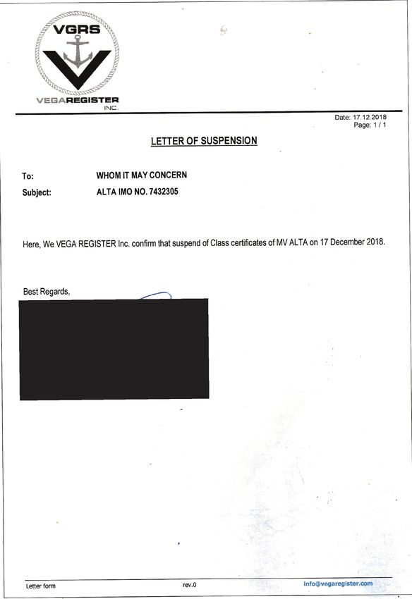
that the ship was removed from its Register and Classification Society “VEGA” in
Note 2 : Reference ‘National Oil Spill Contingency Plan’ published 27th June 2020:
https://www.gov.ie/en/publication/79e5d-national-maritime-oilhns-spill-contingency-plan-
nmoscp/Cont. NARRATIVE
2018 (see Appendix 7.2 Details of Tanzania Vessel Registration). The owner at
that time, Alta Shipping LLC of Miami, failed to renew the flag certification
which expired on 25 September 2018 some 2 days before the voyage should have
concluded on 27 September 2018. It was therefore not registered for the entire
voyage to the time it was abandoned on 8 October 2018. MCIB understand that
Tanzania has since temporarily closed its maritime registry to foreign vessels
while it reviews the status of all ships flying its flag.
9ANALYSIS
4. ANALYSIS
4.1 The vessel was abandoned and adrift in the Gulf Stream (see Appendix 7.5
Currents and Winds in the North Atlantic Ocean - Figure 1 – Gulf Stream). Being
abandoned and adrift, the vessel was a derelict by virtue of definition. Derelict
vessels, on the high seas, are a danger to navigation to other vessels,
particularly during times of restricted visibility. The Gulf Stream influenced the
derelict’s meanderings across the seas, initially northwards along the eastern
seaboard of the United States of America and then westwards as its meandering
direction became influenced by the mid latitude westerly winds.
See Appendix 7.5 Currents and Winds in the North Atlantic Ocean - Figure 2 –
Atlantic Trade Winds.
The combination of dynamic influences of the Gulf Stream currents and the mid
latitude westerly winds pushed the derelict towards Europe and the seas off
Ireland.
4.2 The purpose of this MCIB investigation is to consider the risks to Ireland from the
abandoned vessel and not to assess the liability or otherwise arising from its
abandonment or issues relating to registration and ownership. Risks to Ireland
include:
• Litigation as to ownership.
• Danger to other vessels of safe navigation posed by a derelict.
• Environmental impact.
• Impact of financial ramifications to the State.
4.3 Ownership
Ship registration refers to the process of documenting a ship's given nationality.
The country to which a ship is registered is called its “flag state”. A ship is bound
by the laws of its flag state. A ship's flag state exercises regulatory control over
the vessel and is required by international agreements to inspect the vessel
regularly, certify the ship's equipment and crew, and issue safety and
environmental protection documents and certificates. Part of the active
certification of a vessel involves regular surveys by representatives of the flag
state to ensure the vessel is maintained, that the crew are qualified and that
measures are in place to effect repairs, such as maintenance plans and minimum
spare parts lists. Should a vessel suffer a breakdown and the crew are unable to
make repairs, then the owner’s representatives should have in place
contingency plans to aid the vessel’s crew. These plans are audited as part of
the ISM certification process. ‘MV Alta’ changed registry and ownership several
times. The vessel was deleted from the Classification Society Register and was
finally deleted from the register of Tanzania in 2018, after it was abandoned.
Thus, the ship was abandoned and set adrift as a stateless ship and its ownership
10Cont. ANALYSIS
is unknown at this juncture. ‘MV Alta’ is now a wreck having drifted ashore and
stranded on the shore near Ballycotton, County Cork.
4.4 The 2007 Nairobi International Convention on the removal of wrecks provides a
sound legal basis for coastal States to remove, or have removed, from their
coastlines:
• Wrecks which pose a hazard to the safety of navigation.
• Wrecks which pose a threat to the marine and coastal environments.
• Or both the above.
The Convention makes shipowners financially liable and requires them to take
out insurance or provide other financial security to cover the costs of wreck
removal. It also provides states with a right of direct action against insurers.
Ownership of ‘MV Alta’ is unknown and the vessel insurers (if any) are not
known. The risk of litigation regarding vessel ownership is therefore considered
low. The State is empowered through the 2007 Nairobi Convention to remove the
wreck of ‘MV Alta’.
4.5 Safe Navigation
‘MV Alta’ was a derelict drifting in navigable waters off the coast of Ireland in
the State’s territorial seas. The ship had no means for advertising its presence
to other ships in the vicinity other than by being seen visually by observers on
the other ships. Apart from being visibly seen by human observation, merchant
ships are normally visible, electronically, to other vessels and the coastal state
authorities by the following ways and means:
4.5.1 Automatic Identification System (AIS). All merchant ships are required to be
fitted with an AIS transponder and receiver. This is a VHF based system which
broadcasts information from the ship to be received by surrounding ships in the
area. AIS can also be received by satellites and can be referred to as satellite S-
AIS. This can then be relayed to shore stations or other receivers. Therefore,
even for ships located far from the coast, AIS can still locate them through using
satellites. A ship requires active electrical power onboard to power the
identification system, therefore, in cases of a derelict, such as the ‘MV Alta’,
where the ship has no operating electrical power systems the AIS would not be
operating.
4.5.2 Long Range Identification and Tracking (LRIT). The main purpose of LRIT ship
position reports is to enable a Contracting Government to acquire a ships
identity and location information within a sufficient time range to evaluate any
security risks posed by a ship off its coast. All registered merchant ships are
required to be fitted with LRIT. LRIT is a satellite-based system and is managed
by the flag state of the ship. The ship also requires active systems onboard
enabling LRIT to operate. In this case the ship was stateless, abandoned, and
unpowered. Therefore, coastal states, such as Ireland, were not able to acquire
11ANALYSIS Cont.
the ships position or identity as it approached Irish waters. ‘MV Alta’ was
derelict and abandoned with no active systems onboard enabling LRIT.
4.5.3 All merchant ships, fishing vessels and some larger recreational craft are fitted
with radar. Thus, they would be capable of locating floating objects when within
range. It is assumed that this is what occurred when the ‘HMS Protector’ found
the vessel. There is no record of the sighting by any other vessels, or any reports
being referred to Irish authorities such as the IRCG or the MSO. Therefore, no
navigation warnings were issued although the vessel represented a real danger
to navigation at that time.
4.5.4 Ireland does not have a network of shore-based radar installations scanning the
open coastal seas. Therefore, the ship could not be detected by a shore based
radar system operating from Ireland.
4.6 The Irish Coast Guard, IRCG, maintains three radio stations in Ireland. These
stations are in Dublin, Malin Head, County Donegal, and Valentia, County Kerry.
These stations are continually operated on a 24-hour basis enabling emergency
responses and coordination for maritime incidents offshore in addition to direct
ship/shore, shore/ship marine communications and monitoring of same. ‘MV
Alta’ was not active on the radio communications frequencies and any sightings
of the derelict by other vessels were not reported or made known to the IRCG.
4.7 The Irish Naval Service (INS) is the maritime element of the Defence Forces. In
addition to its primary role, ships of the Irish Naval Service carry out fishery
protection patrols in the Irish sector of responsibility in the EU’s Exclusive
Economic Zone (EEZ). During normal operations, the Irish Navy may be expected
to have three ships at sea at any time patrolling an area several times larger
than the island of Ireland. In support of its fishery protection task, the INS
operate a land based Fishery Monitoring Centre (FMC) at the Naval Base,
Haulbowline, County Cork. This centre is continually manned and operational on
a 24-hour basis. The primary task of FMC is to monitor fishing activities in Irish
and EU waters and use the information and data gained to focus the patrol
activities of its ships when on fishery protection taskings. When specifically
required, the FMC is capable of monitoring ship movements in Irish waters if the
ships in question are fitted with active LRIT and/or AIS. The presence of ‘MV
Alta’ whilst in EU or Irish waters was not reported by other vessels. The ship was
not visually sighted by a naval patrol, and as the derelict was not fitted with
active LRIT or AIS systems it would not appear on FMC monitoring equipment.
4.8 Other earth observation services such as the European Maritime Safety Agency,
(EMSA) ‘CleanSeaNet’ and ‘Copernicus Maritime Surveillance’ services routinely
collect satellite imagery over the oceans. However, imagery resolution data
from the satellite is insufficient to randomly scan the sea surface to detect and
identify a derelict. The satellites with high enough resolution only make images
12Cont. ANALYSIS
on demand or of particular areas. Earth Observation Services are not enabled for
detection of derelicts such as the ‘MV Alta’.
4.9 EMSA also provides support to the Member States and to EU institutions by
maintaining an operational Maritime Support Service (MSS), and provides, on
request, a range of systems to Member States in facilitating identification and
tracking of ships. However, the EMSA systems are based on AIS, LRIT and S-AIS.
‘MV Alta’ was not fitted with active LRIT or AIS systems and would not appear
on EMSA MSS systems.
During the period when the derelict ‘MV Alta’ was adrift, unidentified and
without an electronic signature, the ship posed a significant navigation hazard
to commercial and recreational vessels in its vicinity. The only safeguard these
vessels had was a reliance on their onboard radar systems and the diligence of
the bridge and wheelhouse watchkeepers in keeping a good look out,
particularly at times of reduced visibility.
4.10 Environmental Impact
Wrecks, when lying in a fairway and in water of not sufficient depth to allow
vessels to pass without striking, may pose a danger to safe navigation to other
vessels. In the vessels present position, the ‘MV Alta’ is a wreck and poses no
danger to other ships. However, in its present position, the vessel has a potential
risk over time of environmental impact due to decomposition of its materials of
construction (metals and plastics), leakages of manufactured fluids (oils and
lubricants) and subsequent pollution of the environment.
4.10.1 The regulation of pollution coming from a vessel such as air emissions, oily
discharges, sewage, waste etc. is regulated by the IMO MARPOL Convention and
associated European and National legislation. In the case of Ireland, MARPOL
classified pollution is regulated by the DoT and the MSO but not the EPA. The EPA
regulates all other forms of pollution in the marine/maritime environment and
pollution in the water column itself.
4.11 The IRCG is responsible for cleaning-up or co-ordinating the clean-up after a
spill whether ship-sourced or not (see Note 2).
In its present position stranded ashore near Ballycotton, the wreck has a visual
impact to the casual observer due to its location and appearance. The wreck lies
on a known tourist route (The Wild Atlantic Way) and while the wreck remains
an identifiable ship and an object of curiosity, as time passes the wreck, if not
removed, will inevitably deteriorate to an unsightly collection of rusting plates
and plastic wreckage. The ‘MV Alta’ poses a potential for environmental
pollution, both materially and visually.
13CONCLUSIONS
5. CONCLUSIONS
5.1 The ‘MV Alta’ suffered a mechanical breakdown and was abandoned and set adrift
by its owners and crew in October 2018. During the following 16 months the
derelict drifted eastwards across the Atlantic Ocean, presenting a danger to safe
navigation for all other vessels and offshore fixed installations in its vicinity and a
danger of injury or death to their crews and operators. As the derelict drifted into
EU waters and the territorial seas of Ireland the responsibility for responding to a
maritime incident caused by collision with the derelict ship rested with Ireland and
its maritime search and rescue agencies.
5.2 ‘MV Alta’ grounded on the coast of Ireland. The likelihood of pollution as the wreck
breaks up is high and will remain so until the wreck is removed. The costs of
removal will likely be borne by the State. The monitoring and tracking of ships and
vessels offshore is achieved by means of AIS, and/or LRIT electronic systems
activated onboard the individual ships. These electronic systems require electrical
supplies onboard the tracked ship. These electronic systems are ineffective in
situations involving derelict ships such as the ‘MV Alta’ as they have no electrical
power source onboard.
14SAFETY RECOMMENDATIONS
6. SAFETY RECOMMENDATIONS
6.1 The Minister for Transport should, together with the Minister for Defence and the
Minister for Agriculture, Food and the Marine, form a working group comprising
members from the Irish Coast Guard, the Naval Service, Irish Lights, the Sea
Fisheries Protection Authority and other interested parties. The working group
should explore the risks and potential costs to the State presented by derelict ships
entering Irish territorial waters and coming ashore in Ireland and make proposals
for means to identify, monitor, track and interdict derelict ships before they
endanger other ships and seafarers in the vicinity. The working group should be also
aware of the EU dimension and be prepared to make recommendations to other
European agencies including EMSA on their deliberations.
15APPENDICES
7. APPENDICES
PAGE
7.1 Photographs 17
7.2 Details of Tanzania Vessel Registration 18
7.3 Chart of Distance Travelled 21
7.4 Ireland’s Zone of Responsibility
– In this case the Exclusive Economic Zone (EEZ) 22
7.5 Currents and Winds in the North Atlantic Ocean 23
16APPENDIX 7.1
Appendix 7.1 Photographs
Photograph No.1 – ‘MV Alta’ aground in Ballyandreen Bay, Co. Cork.
17APPENDIX 7.2 Cont.
Appendix 7.2 Details of Tanzania Vessel Registration
18Cont. APPENDIX 7.2
Appendix 7.2 Details of Tanzania Vessel Registration
19APPENDIX 7.2 Cont.
Appendix 7.2 Details of Tanzania Vessel Registration
20APPENDIX 7.3
Appendix 7.3 Chart of Distance Travelled
21APPENDIX 7.4
Appendix 7.4 Ireland’s Zone of Responsibility
– In this case the Exclusive Economic Zone (EEZ)
22APPENDIX 7.5
Appendix 7.5 Currents and Winds in the North Atlantic Ocean
Figure 1 – Gulf Stream.
Figure 2 – Atlantic Trade Winds.
23MSA 2000 SECTION 36
SECTION 36 PROCESS
Section 36 of the Merchant Shipping (Investigation of Marine Casualties) Act, 2000
It is a requirement under Section 36 that:
(1) Before publishing a report, the Board shall send a draft of the report or sections of
the draft report to any person who, in its opinion, is likely to be adversely affected
by the publishing of the report or sections or, if that person be deceased, then such
person as appears to the Board best to represent that person’s interest.
(2) A person to whom the Board sends a draft in accordance with subsection (1) may,
within a period of 28 days commencing on the date on which the draft is sent to the
person, or such further period not exceeding 28 days, as the Board in its absolute
discretion thinks fit, submit to the Board in writing his or her observations on the
draft.
(3) A person to whom a draft has been sent in accordance with subsection (1) may apply
to the Board for an extension, in accordance with subsection (2), of the period in
which to submit his or her observations on the draft.
(4) Observations submitted to the Board in accordance with subsection (2) shall be
included in an appendix to the published report, unless the person submitting the
observations requests in writing that the observations be not published.
(5) Where observations are submitted to the Board in accordance with subsection (2),
the Board may, at its discretion -
(a) alter the draft before publication or decide not to do so, or
(b) include in the published report such comments on the observations as it thinks
fit.’
The Board reviews and considers all observations received whether published or not
published in the final report. When the Board considers an observation requires
amendments to the report that is stated beside the relevant observation. When the Board
is satisfied that the report has adequately addressed the issue in the observation, then
the observation is ‘Noted’ without comment or amendment. The Board may make further
amendments or observations in light of the responses under Section 36. ‘Noted’ does not
mean that the Board either agrees or disagrees with the observation.
Response(s) received following circulation of the draft report are included in the
following section.
24CORRESPONDENCE
8. SECTION 36 - CORRESPONDENCE RECEIVED
No correspondence was received on the draft of this report.
25NOTES 26
NOTES

        27
NOTES 28
Leeson Lane, Dublin 2.
Telephone: 01-678 3485/86.
    email: info@mcib.ie
       www.mcib.ie
You can also read