Iran Drought Monitoring in April 2021 - Research Square
←
→
Page content transcription
If your browser does not render page correctly, please read the page content below
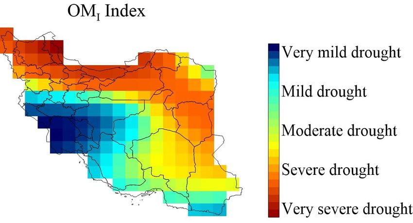
Iran Drought Monitoring in April 2021
 Omid Memarian Sorkhabi

 (omidmemaryan@gmail.com)

 Department of Geomatics Engineering, Faculty of Civil Engineering and Transportation, University of Isfahan,
 Isfahan, Iran.

Abstract
About a third of the world's continents and large parts of Iran are facing drought,
which is hampering water supply and water supply management. The problem of
drought is a natural phenomenon that causes water shortages in many countries every
year. Currently, about 80 countries are located in arid and semi-arid regions of the
world and Iran is one of these countries with an average rainfall of about 250 mm.
In this study, a new drought index called OMI based on GRACE-FO total water
storage (TWS) observations is developed in April 2021. The northern and
northwestern regions of Iran have lost about 0.32 meters of TWS. Central and eastern
Iran have lost about 0.18 meters of TWS. The southwestern regions of Iran are in a
better situation this month than other regions. The eastern and southeastern regions
are very mid drought, the northern, northeastern, and northwestern regions are very
severe drought. The southeastern areas are moderately drought.
Keywords: Drought Monitoring, GRACE-FO, Iran, TWS

 1
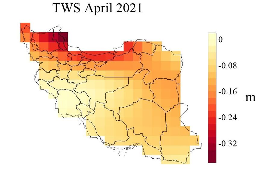
Introduction
The GRACE and GRACE-FO satellites have become very important in drought
studies by estimating TWS. Due to the complexity of hydrological phenomena,
satellite monitoring of water movement plays a key role. Various studies show the
success of TWS in drought monitoring [1-3].
In this research, GRACE-FO satellite data in April 2021 has been used to examine
the drought situation in Iran by province.
Methodology
The following index has been developed for Iran's drought called OM Index.

 TWSi − min(TWSm)
 OMI =
 m (TWSm) − min(TWSm)
 )1(
Where TWSi is the TWS in different areas, TWSm average monthly TWS. OMI
values are between 0 and 1, and the closer it is to zero, the drier the region than
normal, and the closer it is to one, the wetter the region than normal. Of course, the
positive and negative of TWS change the interpretation of OMI .
Results
In this research, the GRACE satellite has been used to estimate TWS based on the
proposed in-depth learning and wavelet process [4-16]. Figure 1 shows the TWS
changes in April 2021 by the GRACE-FO satellite. The northern and northwestern
regions of Iran have lost about 0.32 meters of TWS. The central and eastern areas
have lost about 0.18 meters of TWS. The southwestern regions of Iran are in a better
situation this month than other regions.

 2
Figure 1 TWS changes in April 2021 by GRACE-FO satellite
Figure 2 shows the OMI drought index for April 2021. The eastern and southeastern
regions are very mid drought, the northern, northeastern, and north-western regions
are very north drought. The southeastern areas are moderately drought.

 3
Figure 2 OMI for April 2021
Conclusion
Drought is one of the most important and destructive climatic phenomena, the
impact of which is usually more important on a regional scale. The average rainfall
of Iran in the water year 2019-2020 with a record of 342 mm caused this year to
break the record of the rainiest year in the last 50 years. However, in the following
year, 2020-2021, the amount of precipitation was 317 mm and a lower average was
recorded. The new OMI is suitable for drought studies. The eastern and southeastern
regions are very mid drought, the northern, northeastern, and northwestern regions
are very severe drought. The southeastern areas are moderately drought.
Competing interests:
The authors declare no competing interests.
References
[1] Le DN, Parvathy VS, Gupta D, Khanna A, Rodrigues JJ, Shankar K. IoT enabled depthwise
separable convolution neural network with deep support vector machine for COVID-19 diagnosis
and classification. International Journal of Machine Learning and Cybernetics. 2021 Jan 2:1-4.
[2] Kumar A, Vashishtha G, Gandhi CP, Zhou Y, Glowacz A, Xiang J. Novel convolutional neural
network (NCNN) for the diagnosis of bearing defects in rotary machinery. IEEE Transactions on
Instrumentation and Measurement. 2021 Feb 1;70:1-0.

 4
[3] Wu, T., Zheng, W., Yin, W., & Zhang, H. (2021). Spatiotemporal Characteristics of Drought
and Driving Factors Based on the GRACE-Derived Total Storage Deficit Index: A Case Study in
Southwest China. Remote Sensing, 13(1), 79.
[4] Sorkhabia OM, Asgaria J, Amiri-Simkooeia A. Mass Change Survey with GRACE-FO. 2020.
[5] Memarian Sorkhabi O. Geoid determination based on log sigmoid function of artificial neural
networks:(a case study: Iran). Journal of Artificial Intelligence in Electrical Engineering. 2015 Mar
1;3(12):18-24.
[6] Sorkhabia OM, DJAMOUR Y. Wavelet Transform Analysis of Ionospheric Electron Content
Changes before Large Earthquakes. Journal of Geomatics Science and Technology, 2015.
[7] Sorkhabi OM, Jahantab A. Evaluation of Total Electron Content before Large Earthquake.
2015.
[8] Sorkhabi OM, Naderi A, Emadi R. Terrain Effect on Geoid Determination Case Study: NW
Iran. Journal of Geomatics Science and Technology. 2014 Nov 10;4(2):139-48.
[9] Sorkhabi OM. Farhadian a. Geoid height determination based on back propagation artificial
neural network (case study: northwest iran). 2014.
[10] Sorkhabi OM. Deep learning of dynamic sea-level variability to investigate the relationship
with the floods in Gothenburg. 2021.
[11] Memarian Sorkhabi O,, Asgari J, Amiri-Simkooei A. Monitoring of Caspian Sea-level
changes using deep learning-based 3D reconstruction of GRACE signal. Measurement. 2021 Apr
1;174:109004.
[12] Memarian Sorkhabi O, Asgari J, Amiri-Simkooei A. Wavelet decomposition and deep
learning of altimetry waveform retracking for Lake Urmia water level survey. Marine
Georesources & Geotechnology. 2021 Mar 10:1-1.
[13] Memarian Sorkhabi O, Djamour Y. Estimation of Geodetic Virtual Velocity Based On Back
Propagation Artificial Neural Networks (Case Study: NW Iran). Journal of Geoscience. 2015 Jun
1;24(95):69-76.
[14] Memarian Sorkhabi O. Geoid determination based on log sigmoid function of artificial neural
networks:(a case study: Iran). Journal of Artificial Intelligence in Electrical Engineering. 2015 Mar
1;3(12):18-24.
[15] Memarian Sorkhabi O, Asgari J, Amiri Simkooei A. Analysis of Greenland mass changes
based on GRACE four-dimensional wavelet decomposition. Remote Sensing Letters. 2021 May
4;12(5):499-509.
[16] Sorkhabia OM, Asgaria J, Amiri-Simkooeia A. Caspian Sea Level Survey with GRACE and
GRACE-FO. 2020.

 5
You can also read