Jamaica Bay Institute - Research Opportunities in the Natural and Social Sciences
←
→
Page content transcription
If your browser does not render page correctly, please read the page content below
Jamaica Bay Institute

             Research Opportunities
           in the Natural and Social Sciences
                         at the
                  Jamaica Bay Unit of
           Gateway National Recreation Area
Prepared for:
      National Park Service
       Jamaica Bay Institute
       1 Floyd Bennett Field
     Headquarters Building 69
       Brooklyn, NY 11234

           Prepared by:
          John Waldman
Biology Department, Queens College
     65-30 Kissena Boulevard
        Flushing, NY 11367

           April 2008
Table of Contents
About the Jamaica Bay Unit of Gateway National Recreation Area……..…1
Location and Basic Characteristics (with map)……………………………….…4
Selected Bibliography for Location and Basic Characteristics………………...5

    Coastal Geomorphology
        Background…………………………………………………………………………6
        Research Needs…………………………………………………………………….7
        Selected Bibliography for Coastal Geomorphology………………………….9

    Atmospheric Deposition Monitoring
        Background………………………………………………………………………..10
        Research Needs………………………………………………………………..….11
        Selected Bibliography for Atmospheric Monitoring……………………..…11

    Aquatic Ecology
    Habitat Restoration
        Background………………………………………………………………………..12
        Research Needs…………………………………………………………...………13
             Salt Marshes……………………………………………………………...…..13
             Freshwater Wetlands and Basins…………………………………………... 15
             Oyster Reefs………………………………………………………………..…16
             Eelgrass………………………………………………………………..………17
             Other Aquatic and Wetland Plant Communities…………………… ……..18
             Borrow Pits……………………………………………………………………19
             Dead-ended Creeks…………………………………………………………..20
             Bay to Upland Transition Habitat…………………..………………………..21
        Selected Bibliography for Habitat Restoration………………………………22

    Invasive Aquatic Species
        Background……………………………………………………………….……….24
        Research Needs…………………………………………………………………...24
        Selected Bibliography for Invasive Aquatic Species………………………..26

    Chemical Contamination
        Background………………………………………………………………………..27
        Research Needs……………………………………………………..…………….28
        Selected Bibliography for Chemical Contamination……………..…………28

    Nutrient Enrichment and Eutrophication
        Background………………………………………………………………….…….30
        Research Needs……………………………………………………………….…..31
        Selected Bibliography for Nutrient Enrichment and Eutrophication…….32

    Marine Debris
        Background…………………………………………………………………..……33
        Research Needs…………………………………………………………………...34
        Selected Bibliography for Marine Debris………………………………….....34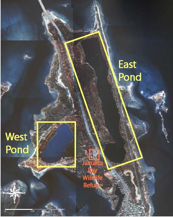
Plant Ecology
   Background………………………………………………………………………..35
   Research Needs………………………………………………………………..….35
        Grasslands……………………………………………………………..……..35
        Non-native Plant Species and Invasives………………………………….…36
        State-Listed Rare Plants………………………………………………….…..37
        Fire Management…………………………………………………………....38
   Selected Bibliography for Plant Ecology…………………………………..…39

Wildlife Ecology
   Background……………………………………………………………….….……40
   Research Needs……………………………………………………..……..….…..41
        Diadromous Fishes……………………………………………………………41
        Marine Fishes………………………………………………………..………..42
        Shellfish……………………………………………………………………….43
        Horseshoe Crab………………………………………………………………44
        Diamondback Terrapin………………………………………………………45
        Other Reptiles and Amphibians……………………………………..………46
        Passerine Birds……………………………………………………….……….47
        Shorebirds…………………………………………………………………….48
        Waterfowl……………………………………………………………….……49
        Harbor Herons………………………………………………………………..49
        Cormorants…………………………………………………………………..50
        Raptors…………………………………………………………………..……51
        Mammals……………………………………………………………..………52
        Insects……………………………………………………………….………..53
   Selected Bibliography for Wildlife Ecology………………………………….54

Warming and Sea Level Rise
   Background…………………………………………………………….….………57
   Research Needs…………………………………………………………..……….58
   Selected Bibliography for Warming and Sea Level Rise………….…….….58

Social Sciences
   Background…………………………………………………………………..……59
   Research Needs……………………………………………………………….…..59
   Selected Bibliography for Social Sciences…………………………….………64

Appendices
   Application Procedures and Regulations for Scientific Research and
   Collecting Permits……………………………………………………………..…65
   Guidelines to Researchers for Study Proposals……………………………..73
Jamaica Bay Research Opportunities

          About the Jamaica Bay Unit of Gateway National Recreation Area

The Gateway National Recreation Area (Gateway NRA), designated in 1972, is one of the first
urban national parks. Gateway NRA includes Sandy Hook, New Jersey, tracts along the south
side of Staten Island, Jamaica Bay, Floyd Bennett Field, and Breezy Point in New York. One of its
primary components is the Jamaica Bay Unit. Jamaica Bay is a large water body that drains
portions of Brooklyn, Queens, and Nassau counties of New York and discharges to the Atlantic
Ocean through Rockaway Inlet. The Jamaica Bay Unit is approximately 6,500 hectares (16,000
acres) in area, about 75% water and wetlands and 25% uplands.

 All three districts of Gateway National Recreation Area          The Jamaica Bay Unit of Gateway National Recreation Area

Although Jamaica Bay is natural, it is located within a heavily populated region and portions of it
have received considerable modification by humans. Nonetheless, Jamaica Bay is one of the
largest areas of open space within New York City; a significant natural area within one of the
nation’s most populous urban centers. Both within the Unit and in the heart of the bay itself, the
Jamaica Bay Wildlife Refuge encompasses 3,700 hectares (9,155 acres) and is comprised of
diverse habitats, including salt marsh, several fresh and brackish water ponds, upland fields and
woods, and an open expanse of bay studded with islands.

                                                       The Jamaica Bay Wildlife Refuge provides important
                                                       habitat for both resident and migratory animals—most
                                                       famously—for its birds, with more than 325 species
                                                       having been seen there. Jamaica Bay is a critical stop-
                                                       over area on the Eastern Flyway Migration Route. It is
                                                       widely known as one of the best bird- watching
                                                       locations in the western hemisphere; in fact, it was the
                                                       first site to be designated by the National Audubon
                                                       Society as an “Important Bird Area.” Jamaica Bay also
                                                       hosts large numbers of seasonally resident fishes,
                                                       crustaceans, and horseshoe crabs
Osprey lands on nest platform in the Jamaica Bay
Wildlife Refuge

-1-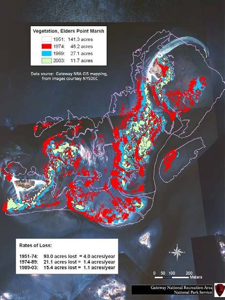
Jamaica Bay Research Opportunities

This abutment of wild habitat and natural resources with urbanity makes management of
Jamaica Bay complicated. More than 25 federal, state, and local agencies have some
jurisdictional responsibilities in the bay, and numerous private and public entities have strong
ties to it. However, the National Park Service has a uniquely broad purview of the Unit portion
of Jamaica Bay. Its mission statement includes that “The Secretary shall administer and protect
the islands and waters within the Jamaica Bay Unit with the primary aim of conserving the
natural resources, fish, and wildlife located therein and shall permit no development or use of
this area which is incompatible with this purpose.” This is part of a larger mission for Gateway
NRA that maintains, improves, and makes its resources available to the public for inspiration,
education, and recreation. These include sites of critical natural and cultural importance to the
maintenance and sustainability of local ecosystems, to the life of migratory and native species,
and to the military, navigational, and aviation history of the region and the nation, especially in
the context of the coastal defense of New York Harbor.

                                                -2-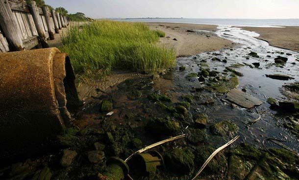
Jamaica Bay Research Opportunities
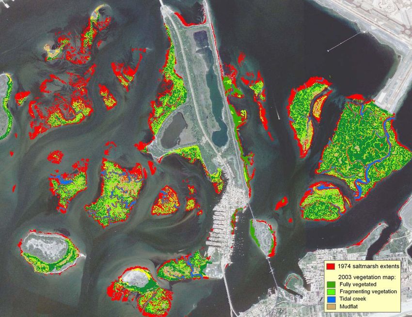
Map demonstrating marsh loss in Jamaica Bay from 1974 to 2003
Strengthened environmental regulations and concerned citizens have greatly improved
conditions in Jamaica Bay and, today, the bay can serve as a model for how the degraded
resources of an urban water body can be rehabilitated. However, the bay is dynamic and not all
of its changes are positive, most alarmingly, the trend towards disappearance of its salt marsh
islands (Hartig et al. 2002). Nor are all aspects of its environment as well understood as they
should be to best manage the bay. To help steer further scientific inquiry into this complex,
stressed, but resilient ecosystem, creation of a research opportunities catalog was proposed, as
have been developed for other National Parks. This research catalog for the Jamaica Bay Unit of
Gateway National Recreation Area has two main objectives:
• A Research Opportunities catalog will identify research needs that will directly assist park
management in their efforts to better understand the park’s natural resources and support
resource protection actions.
• A Research Opportunities document will identify opportunities to study species, habitats,
processes, and ecological principles within an urban setting: and the connections the
metropolitan community has to these resources.
Thus, we hope that this catalog of research opportunities for the Jamaica Bay Unit of Gateway
NRA will highlight the availability of this site as a potentially world- class laboratory for research
on the wildlife and environment of an urban park and, that it will focus scientific study on
questions that will help maintain and perpetuate the bay’s environmental recovery so that it can
continue in its role as a superb urban wildlife amenity. It is intended that this catalog be updated
on a periodic basis.
-3-
Jamaica Bay Research Opportunities

Location and Basic Characteristics
Maps in this section can be found at http://nbii- nin.ciesin.columbia.edu/jamaicabay/maps.html
The word “Jamaica” comes from the Jameco or Yamecah Indians, part of the Canarsie tribe, who
inhabited the northern shores of what is known today as Jamaica Bay. Jamaica Bay is situated at
the southwestern end of Long Island, as the westernmost of the island’s large south shore bays.
It is located primarily within the New York City boroughs of Brooklyn and Queens, with a small
eastern portion extending into the Town of Hempstead in Nassau County, New York. The bay
is protected by a barrier beach and it connects with the sea through Rockaway Inlet at its
western end. The Jamaica Bay watershed, including NPS and all other holdings is approximately
36,900 hectares (91,000 acres) in size; open water and wetlands extend for about 5,300 hectares
(13,000 acres).

Jamaica Bay is embedded within a heavily urbanized region with extremely high population
densities. According to 2005 U.S. Census Bureau estimates, there were 2,486,235 people residing
in Brooklyn and 2,241,600 in Queens alone, part of the more than 8 million population of New
York City and the nearly 22 million of the New York City metropolitan region.
Jamaica Bay has been characterized as a temperate, eutrophic estuary, with open water salinities
                                                                          o      o
ranging from about 20 to 26 parts per thousand (ppt), temperatures from 1 C to 26 C, and pH

                                                -4-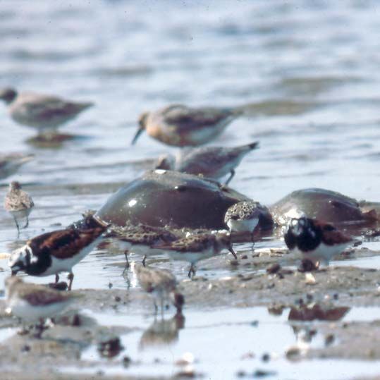
Jamaica Bay Research Opportunities

from 6.8 to 9 (USFWS 1997). Muddy fine sand is the primary sediment of the eastern and
northern portions of the bay, while fine to medium sands predominate in the higher energy
southern and western sections nearer to Rockaway Inlet (USFWS 1997). Jamaica Bay’s original
average low tide depth of about 3 feet has been increased to 16 feet through landfilling of
shallows, channel dredging, and the removal of sediments from “borrow” pits, some of which
exceed 50 feet in depth. Because of these changes, the average residence time of a water
molecule in the northern portion of the bay has risen from 11 days to 33 (NYCDEP 1994), with
dredging accounting for a 70% increase in the volume of the bay (Rhoads et al. 2001). The bay’s
original network of freshwater and brackish creeks have been shortened, straightened,
bulkheaded, and channelized, with two- thirds of the freshwater runoff diverted through four
sewage treatment facilities. Thus, salinity gradients are now minimized within the system.
Freshwater inputs total approximately one- half of one percent of the bay’s volume per day
(Rhoads et al. 2001).

                                                       These alterations to the original pattern of freshwater
                                                       discharge have been so radical that the watershed of
                                                       Jamaica Bay is sometimes referred to as a
                                                       “sewershed”—a distinctly urban concept. Sewage
                                                       treatment facilities contribute about 287 million gallons
                                                       of treated effluent per day (West- Valle et al. 1991).
                                                       Each semidiurnal tidal cycle (approximately 5- foot
                                                       range) exchanges approximately one- third of the
                                                       volume of the bay through Rockaway Inlet. This
                                                       flushing plus the benefits of improved sewage
                                                       treatment (Brosnan et al. 2006) have caused the water
 Drain pipes empty into Jamaica Bay affecting          quality of Jamaica Bay to greatly improve since the
 the water quality of the bay and the salinity of      Clean Water Act.
 surrounding areas.

Selected Bibliography for Location and Basic Characteristics.

Brosnan, T.M., A. Stoddard, and L.J. Hetling. 2006. Hudson River sewage inputs and impacts: Past and Present. Pages 335- 348
in J.S. Levinton and J.R. Waldman, editors. The Hudson River Estuary. Cambridge University Press, New York, NY.

NPS (National Park Service). Undated. The evolving legacy of Jamaica Bay. Gateway National Recreation Area, National Park
Service.

NYCDEP (New York City Department of Environmental Protection). 1994. Jamaica Bay comprehensive watershed
management plan. New York, NY.

Rhoads, J.M., D.J. Yozzo, M.M. Cianciola, and R.J. Will. 2001. Norton Basin/Little Bay Restoration Project: historical and
environmental background report. Report to U.S. Army Corps of Engineers.

USFWS (U.S. Fish & Wildlife Service). 1997. Significant habitats and habitat complexes of the New York Bight watershed. U.S.
Fish & Wildlife service, Southern New England, New York Bight Coastal Ecosystems Program, Charlestown, RI.

West- Valle, A.S., C.J. Decker, and R.L. Swanson. 1991. Use impairments of Jamaica Bay. Waste Management Institute, Marine
Sciences Research Center, State University of New York, Stony Brook, NY.

                                                              -5-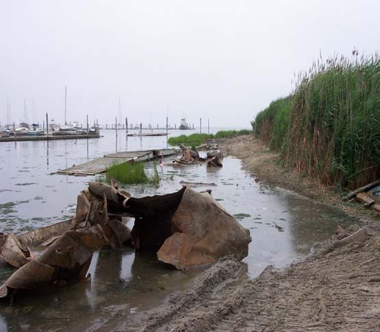
Jamaica Bay Research Opportunities

Coastal Geomorphology

Background.

                                                  Jamaica Bay is a geomorphologically recent and
                                                  dynamic system (JABERRT 2002). It is post-
                                                  Pleistocene in origin—nestled within the outwash
                                                  plain of Long Island’s Harbor Hill Moraine—and is
                                                  protected from ocean waves by a portion of the long
                                                  barrier beach that lines Long Island’s south shore.
                                                  Within historical times, once- populated Barren Island
                                                  (near Rockaway Inlet) eroded, was abandoned, and
  Map demonstrating the accretion of sand at
  the Breezy Point tip.                           then was landfilled to connect with the mainland as
                                                  part of Floyd Bennett Field. Breezy Point—at the
                                                  western tip of the barrier beach—has steadily
                                                  extended westward. The bay’s interior margin also is
                                                  radically altered through development. Furthermore,
                                                  Jamaica Bay’s island marshes have been eroding at a
                                                  very high rate and there was concern that they may
                                                  eclipse within decades (Hartig et al. 2002). This threat
                                                  has since been updated to disappearance within less
                                                  than a decade (GNRA 2007). Human- made physical
                                                  changes also affect the hydrology and sediment
                                                  budget of the bay; channels are dredged for
                                                  navigation and deep holes (borrow pits) persist from
                                                  which sediments were obtained decades ago for
                                                  landfilling.
Map demonstrating marsh loss from 1951 to 2003.

                                                      -6-
Jamaica Bay Research Opportunities
However, as an urban water body with an enormous population
ringing it, Jamaica Bay has been largely “locked in place” physically
to accommodate human needs. This includes construction of a
broad suite of structures that “harden” it, including jetties, seawalls,
bulkheads, and bridge abutments. Much of this hardening included
(Above) Bulkheading at Floyd geomorphological changes such as the straightening of creeks while
Bennett Field; (Below) The jetty
at Breezy Point. bulkheading, and landfilling wetlands for development. But while
humans have reduced the natural physical dynamism of Jamaica
Bay to meet society’s needs they also have induced new and
potentially powerful stresses such as sea level rise and perhaps
hurricanes and nor’easters of increased frequency and severity
(Najjar et al. 2000; Gornitz et al. 2001). Thus, further
geomorphological change to Jamaica Bay appears likely; how
disruptive to its current uses it will be depends partly on a better
understanding of its natural physical processes.
Research Needs.
The major focus of future work on the geomorphology of
Jamaica Bay should be on its resiliency and adaptability to
the effects of climate change. What will Jamaica Bay look
like in 25, 50, and 100 years? But to place forecasts of sea
level change and the impacts of major storms in perspective,
a better understanding of ongoing physical processes such
Evidence of storm erosion at Floyd
Bennett Field. Pre-hurricane (left) and as shoreline accretion and loss and sediment availability are
post-hurricane (right) Ernesto photos.
Source: Rip Kirby, 2006 needed. Thus, both retrospective and prospective research
needs to be synthesized. Specifically, what is the history of major storms and their effects on the
bay system? Are major geomorphological changes mostly incremental or storm- event related?
These kinds of studies can include assessment of historical records, analysis of sediment cores,
and other methods.
-7-Jamaica Bay Research Opportunities
Salt marshes have long been recognized as serving a role in storm protection – temporarily
storing storm waters and attenuating wave energy. With marsh loss, how will this storm
protection function be affected? The functions of storm water retention and wave attenuation
should be quantified within Jamaica Bay. At present, salt marsh habitat is being converted to
intertidal mudflat. How does the wave attenuation function of vegetated wetlands compare to
intertidal mudflats?
It is important to understand the role of shoreline
hardened shoreline structures on Bay sediment
transport processes. Are there portions of the
hardened Bay shoreline where structures can be
Sediment transport demonstrated in pre- (left) and
post-(right) hurricane Ernesto photos of the beach removed, thereby restoring natural
near Floyd Bennett Field. The beach experienced a
loss of approximately 5 meters in width and 15 geomorphological processes (e.g., cross- shore
meters in elevation depositing the sediment at the
base of the adjacent Marine Parkway Bridge (below). linkages among the nearshore Bay subtidal
Source: Rip Kirby, 2006.
environment, intertidal environment, and adjacent
upland)? Experimental and pilot studies could be
designed to evaluate the response of shoreline
processes to removal of structures.
It is known that there is considerable transport of coarse sediments through the bay’s channels
and that Grassy Bay is a sediment sink (JABERRT 2002) but can a total sediment budget,
including important sources and other sinks be constructed? And can useful predictions be
made from it regarding relationships between sediment budgets and maintenance of salt marsh
and other bay habitats? Is there a definite link between marsh erosion as a sediment source and
borrow pits as a sediment sink? If so, would filling of borrow pits slow marsh loss?
How will sea level rise affect hydrological and salt flux linkage of Jamaica Bay to the broader
Hudson River estuary and New York Bight, as currently understood (Oey et al. 1985)
-8-Jamaica Bay Research Opportunities
Selected Bibliography for Coastal Geomorphology.
GNRA (Gateway National Recreation Area). 2007. An update on the disappearing salt marshes of Jamaica Bay, New York.
National Park Service.
Gornitz, V., S. Crouch, and E.K. Hartig. 2001. Impacts of sea level rise in the New York City metropolitan area. Global and
Planetary Change 32:61- 88.
Hartig, E.K., V. Gornitz, A. Kolker, F. Mushacke, and D. Fallon. 2002. Anthropogenic and climate- change impacts on salt
marshes of Jamaica Bay, New York City. Wetlands 22:71–89.
JABERRT (Jamaica Bay Ecosystem Research and Restoration Team). 2002. Final Report. Division of Natural Resources,
Gateway National Recreation Area, National Park Service and Aquatic Research and Environmental Assessment Center,
Brooklyn College.
Najjar, R.G., H.A. Walker, P.J. Anderson, E.J. Barron, R.J. Bord, J.R. Gibson, V.S. Kennedy, C.G. Knight, J.P. Megonigal, R.E.
O’Connor, C.D. Polsky, N.P. Psuty, B.A. Richards, L.G. Sorenson, E.M. Steele, and R.S. Swanson. 2000. The potential impacts of
climate change on the mid- Atlantic coastal region. Climate Research 14:219- 233.
Oey, L.- Y., G.L. Mellor, and R.I. Hires. 1985. A three- dimensional simulation of the Hudson- Raritan Estuary. Part I:
Description of the model and model simulations. Journal of Physical Oceanography 15:1676- 1692.
-9-Jamaica Bay Research Opportunities
Atmospheric Deposition Monitoring
Background.
Jamaica Bay is situated within an enormous
metropolitan region, which renders it a potential sink
for the deposition of atmospheric contaminants of
local origin. However, it also lies on the east coast of
North America and, hence, is in the path of distantly-
sourced atmospheric contaminants that drift
eastward carried by the prevailing pattern of air flow
across the continent (Lovett 1994). A significant
fraction of Zn, Cu, and Cd present in Jamaica Bay was
New York City contributes vast quantities of
atmospheric contaminants to Jamaica Bay found to enter the system through atmospheric
fallout (Seidemann 1991). Of particular concern among atmospheric pollutants are nitrogen and
phosphorus because of their potential contributions to aquatic eutrophication. However,
estimates from data collected in 2002- 2003 indicate that fallout from neither is a major vector to
Jamaica Bay (NYCDEP 2007). Other compounds are of greater concern. Recent monitoring of
locations in the metropolitan region has shown atmospheric deposition of polychlorinated
biphenyls (PCBs) and polycyclic aromatic hydrocarbons (PAHs) reach the Hudson estuary by
three processes: gas absorption, dry particle deposition, and wet deposition (Totten et al. 2006).
Although there are geographic differences in fluxes of these compounds among regional
locations, as a whole, levels seen are considerably higher than in non- urban areas elsewhere in
the U.S. A number of other compounds are monitored by the New York State Department of
Environmental Conservation as near to Jamaica Bay as Queens College (~13 km); these include
ozone, sulfur dioxide, oxides of nitrogen, carbonyl, and methane
(http://www.dec.ny.gov/docs/07networkplan12.pdf).
- 10 -Jamaica Bay Research Opportunities
Research Needs.
Atmospheric deposition of PCBs and PAHs were monitored at Hudson estuary locations such as
Sandy Hook and Jersey City; however, no regular monitoring has occurred at Jamaica Bay.
There are a number of possible research questions on this topic. How important is atmospheric
deposition of these compounds to their loads in the bay? Does Jamaica Bay’s geographic
position render it differentially more or less of a sink for these pollutants than elsewhere within
the New York metropolitan region? Which other contaminants enter Jamaica Bay in significant
quantities through atmospheric deposition?
Selected Bibliography for Atmospheric Monitoring.
Lovett, G.M. 1994. Atmospheric deposition of nutrients and pollutants in North America: an ecological perspective. Ecological
Applications 4:629- 650.
NYCDEP (New York City Department of Environmental Protection). 2007. Draft Jamaica Bay Watershed Protection Plan.
Seidemann, D.E. 1991. Metal pollution in sediments of Jamaica Bay, New York, USA—An urban estuary. Environmental
Management 15:73- 81.
Totten, L.A., S. J. Eisenreich, C.L. Gigliotti, J. Dachs, D.A. VanRy, S. Yan, and M. Aucott. 2006. Atmospheric deposition of PCBs
and PAHs to the New York/New Jersey Harbor Estuary. Pages 398- 412 in J.S. Levinton and J.R. Waldman (editors). The
Hudson River Estuary. Cambridge University Press, NY.
- 11 -Jamaica Bay Research Opportunities
Aquatic Ecology
Habitat Restoration
Background.
Subsequent to the New York City region’s water quality
having improved following passage of the Clean Water Act of
1972, the emphasis of environmental action has shifted to
habitat restoration and protection (Waldman 1999),
paralleling a nationwide trend sometimes expressed with the
Sediment spray is applied to the pilot
powerful, if inelegant mantra: “It’s the habitat, stupid.”
marsh restoration site, Big Egg Marsh in
Jamaica Bay, to increase the elevation Jamaica Bay is rife with stretches of water and uplands that
have been altered, often drastically, by human actions. Many of these changes are too radical to
be reversed. But others are amenable to at least some change either back toward their original
states, or to some other form that provides an improved level of ecological function. For
example, seven large areas in Jamaica Bay with potential for significant habitat restoration are
discussed in USACE (2003).
A recent comprehensive review of habitat restoration opportunities in the Hudson – Raritan
Estuary includes many references to Jamaica Bay (Bain et al. 2007). Four principles—all
applicable to Jamaica Bay—were adopted by this study: the ecosystem is human dominated, it
has been irreversibly changed, it is dynamic and will change further, and environmental
enhancements can be made by the application of science and technology. Potential actions
could be based on some combination of the primary philosophical rationales for restoration:
returning to the original conditions, the restoration of ecological integrity, health, or stability,
“rewilding” (reestablishment of the original evolutionary setting so that natural evolution guides
the future state of the system, and “renaturing” (designing ecosystems for nature and people).
Eleven sets of target ecosystem characteristics were outlined by Bain et al. (2007) that considered
such topics as oyster reefs, eelgrass beds, wetlands, and fish habitat, among others. This carefully
considered report should serve as something of a blueprint, or at least an important source of
recommendations, for habitat restoration in the bay.
- 12 -Jamaica Bay Research Opportunities
Research Needs.
Salt Marshes.
The salt marshes of Jamaica Bay provide important ecological services, including wildlife habitat,
support for the food web, shoreline erosion control, and water column filtration (GNRA 2007).
Unfortunately, there have been profound losses of salt marsh in Jamaica Bay, in both perimeter
and island locations, but especially the latter. Prior to European colonization, Jamaica Bay
contained about 16,000 acres of salt marsh (USFWS 1997). This vast wetlands wilderness was
whittled away over the subsequent centuries by draining and landfilling, primarily along the
perimeter, until by 1971, only 4,000 acres of salt marsh remained. But since the mid- 1970s most
salt marsh losses have occurred on the islands. Analysis of aerial photographs shows that
between 1924 and 1974, salt marsh disappeared at a rate of 0.4% annually, but that since 1974 the
rate has increased to 1.4% per year (Hartig et al. 2002). Most dramatically, Duck Point marshes
decreased between 1974 and 1999 from 103 acres to 38 acres. Overall island low marsh vegetation
losses since 1974 averaged 38%, with smaller islands losing up to 78% of their vegetation cover
(Hartig et al. 2002). The newest assessment is that five representative island marshes are eroding
at an accelerated rate and may disappear by 2012 (GNRA 2007).
Although salt marshes in other east coast systems are deteriorating because of grazing by salt
marsh periwinkle, Littoraria irrorata (Silliman and Bertness 2002), the recent losses in Jamaica
Bay appear to be caused by a variety of factors, potentially interacting synergistically. These
factors include reduced sediment input, shoreline hardening which eliminate areas for potential
accretion inland to balance deeper water marsh losses, dredging for navigation channels, boat
traffic, sea- level rise, nitrogen pollution, and perhaps grazing (Hartig et al. 2002, NYCDEC
2007).
Maps
demonstrating
predicted marsh
loss occurring in
Jamaica Bay;
marsh islands in
1985 (left) and the
loss predicted for
2024 (right).
- 13 -Jamaica Bay Research Opportunities
Further understanding of the agents of salt marsh loss and their relative contributions is needed.
This includes a better comprehension of the underlying geology and sediment textural and
chemical properties, and of the ecological role of the ubiquitous ribbed mussels, Geukensia
demissa (Franz 2001). Strategies are needed first, to stop additional deterioration, if this is
possible and, second, to rebuild salt marshes. Some pilot remediation efforts have already been
launched, such as on the two islands at Elders Point and the Big Egg Marsh experimental
restoration. Their levels of success and other marsh restoration efforts require stringent
evaluation. The particular metrics used to evaluate success also need to be carefully considered
(Windham et al. 2004).
At the Elders
Point Marsh
restoration site:
(above) planting
Spartina
alternaflora by
hand (below)
fencing acts as
both pathway
guide and
grazing bird
deterrent.
Finally, given that considerable salt marsh loss has occurred and more is likely, assessment of the
ecological value of the resultant mudflat habitat is needed. Which species predominate? Which
are lost? And at what life stages, e.g., what is the net change in nursery functions? How is overall
primary and secondary productivity on a real basis affected? Are there other ecological
ramifications?
- 14 -Jamaica Bay Research Opportunities
Freshwater Wetlands and Basins.
Freshwater habitat for wildlife is very limited in the
Jamaica Bay system. Because of landfilling and
sewer diversions, the freshwater wetlands of
Jamaica Bay now comprise less than 1% of their
historic coverage (NYCDEP 2007). However, the
120- acre East and 45- acre West Ponds,
constructed in the 1950s represent historical
additions of low salinity waters where they had not
occurred. Assessment of the effects of the limited
availability of freshwaters as an ecological resource
for spawning, nurseries, or other habitat values is
needed. If warranted, strategies to increase
ponded freshwaters and freshwater tidal wetlands
should be considered. Can existing flows be
(Above) Map of the Jamaica Bay Wildlife Refuge with
fresh water ponds noted; (Below) A wide variety of augmented? Also, is the invasive plant, purple
birds utilize the fresh water wetlands as both
residence and stopping points along migration routes. loosestrife, Lythrum salicaria, a threat to the
In this photo: East Pond.
remaining freshwater wetlands? As part of this
restoration effort, it would be instructive to
conduct an historical survey to determine the
extent and location of freshwater tidal wetlands
prior to the intensive urban development period,
thereby supporting design of habitat restoration
initiatives.
- 15 -Jamaica Bay Research Opportunities
Oyster reefs.
Oysters, Crassostrea virginica, once were plentiful in Jamaica Bay, with large
middens generated by Native Americans having been left in the Inwood, Hog
Island, and Bayswater sections of the system (Bellot 1917). At its peak, Jamaica
Bay produced 700,000 bushels of oysters per year (Franz 1982). The oyster
beds survived well into the twentieth century but all shellfishing in the bay was
prohibited in 1921 because of diseases transmitted from sewage. Not long after
the bay’s oyster beds were temporarily lost from the severe hurricane of 1938
Illustration of
American oyster (Grambo and Vega 1984). Recovery was only partial, and a further decline
by Anne Yen
ensued, with oysters now either absent or extremely limited in abundance and
distribution. Because oyster beds provide considerable ecosystem services in the form of water
column filtration and nursery habitat for many marine animals (Kirby 2004), there is strong
interest in restoring them throughout New York Harbor and western Long Island, including
Jamaica Bay.
The overriding research question concerning oyster reef restoration in Jamaica Bay is what is
limiting their natural recovery at this time? Experiments conducted by staff at Brooklyn College
suggest that oysters can survive and grow in Jamaica Bay (Potts 2004). However, there is neither
evidence of natural recovery nor even recent definitive sightings of oysters in the wilds of the
bay. Oysters disperse through larval drift—is the bay too far from present- day seed oyster
sources for natural colonization to occur? Given that oysters will survive when placed in the bay
but apparently don’t reproduce, it may be that salinity is the limiting factor. That is, oysters were
prevalent when the creeks leading to the bay had salinity gradients with the brackish conditions
that oysters prefer between the fresh headwaters and the open bay. But routing of street runoff
to sewers has changed most tributaries greatly so that they are now highly saline dead- ended
creeks with little freshwater discharge, unsuitable for oyster reproduction. However, this
hypothesis requires testing.
- 16 -Jamaica Bay Research Opportunities
Eelgrass.
Eelgrass, Zostera marina, is not presently known in
Jamaica Bay. In fact, it is not definitively known to
have occurred there. But, given its historical and
present- day distribution in similar Long Island region
systems, it would appear highly likely that it was native
to the bay. Eelgrass all along the east coast suffered
tremendous declines between 1930 and 1933 because of
“wasting disease,” with only partial recoveries at many
locations (Short et al. 1988). Eelgrass restoration is of
high interest as a goal in other places coastwide
because of its demonstrated value as habitat for a
myriad of forms of marine life (Hughes et al. 2002);
restoration programs presently are occurring in other
Eel grass (Zostera marina) bays on Long Island.
Analysis of historical information—literature or museum holdings—might demonstrate the
historical presence of eelgrass in Jamaica Bay. But the overriding question for generating
eelgrass beds in Jamaica Bay is—what is the limiting factor that prevents natural colonization or
recolonization? Is their non- reestablishment due to a lack of propagules? Or is there an
unrecognized factor, such as turbidity levels that prevent seedlings from surviving? How would
epiphytes interact with eelgrass in the bay? Alternatively, nutrient overenrichment and its
encouragement of marine algae such as Ulva may be preventing eelgrass recolonization. For the
Chesapeake Bay system there are an established suite of factors that necessary for the
establishment and maintenance of seagrass habitats (Dennison et al. 1993); this work and other
similar studies should be reviewed and adapted to Jamaica Bay.
- 17 -Jamaica Bay Research Opportunities
Other Aquatic and Wetland Plant Communities
Jamaica Bay is home to a variety of aquatic and wetland
plant communities whose makeup depends on such
factors as salinity and duration of tidal inundation,
elevation, soil type, and the presence or absence of
nonindigenous competitors and grazers. Marine algae
is found throughout subtidal and intertidal waters of the
bay, with the sea lettuce, Ulva latuca, predominating.
Crew working on the Elders Point Marsh
restoration project inventory and monitor the Wetland herbaceous communities include low salt
variety of plants on Joco Marsh, the control site for
the project. Source: Patti Rafferty marsh, high salt marsh, and freshwater emergent marsh
(NYCDEP 2007). The low salt marsh is dominated by saltmarsh cordgrass, Spartina alterniflora,
whereas salt meadow cordgrass, Spartina patens, predominates in the high salt marsh. However,
the high salt marsh has a greater variety of species, common examples including salt grass,
Distichlis spicata, black grass, Juncus gerardii, glasswort, Salicornia spp., and sea lavender,
Limonium carolinianum. Emergent freshwater marshes are composed of examples such as
pickerelweed, Pontedaria cordata, cattail, Typha spp., and bullrush, Scirpus validus, harbor
sedges, Carex spp., rushes, Juncus spp., and water plantain, Alisma spp.(Mack and Feller 1990).
The identity and distribution of marine algae in Jamaica Bay requires attention. Further
inventorying and mapping of freshwater marsh and salt marsh vegetation is needed, especially
for the latter in light of the dynamic conditions being observed in the bay of ongoing salt marsh
loss and sea level rise. Identification and mapping of state and federally- listed rare and
threatened species should also be encouraged, with the resultant information distributed only
within governmental guidelines. The threat to these communities posed by established invasive
species should be assessed.
- 18 -Jamaica Bay Research Opportunities
Borrow Pits.
Borrow pits, locations where sediments were dredged for landfilling, have been created in
Jamaica Bay since the late 1800s. Materials for Floyd Bennett Field airfield and much of the land
under JFK Airport were obtained from the bay bottom, resulting in borrow pits (NYCDEP
2007). Both Norton Basin and Little Bay contain borrow pits created during the development of
the Edgemere Landfill in 1938 (Rhoads et al. 2001). Although landfilling reduced the area of open
water and wetlands in Jamaica Bay from about 25,000 to 13,000 acres, the creation of borrow pits
and channel dredging have increased the volume of the bay by 350% (NYCDEP 1994). Borrow
pits are problematic because their deeper waters do not circulate well and may stratify in
summer. As plankton and detritus settle into the stratified lower layer, they decompose and
draw down available oxygen without replacement by mixing, thereby creating hypoxic
conditions dissuasive to life. Borrow pits also serve as sediment sinks—areas into which
sediments that might replenish shallow eroded areas (including salt marshes) are lost to the
system.
Potential remediation of borrow pits is centered on the obvious solution of filling them back up
again, either partly or wholly. The primary issue, however, is where to obtain sufficient
sediments that meet federal and state guidelines for contamination? Borrow pits are looked
upon as attractive sinks for unwanted sediments from other areas of New York Harbor. Must
clean sediments only be used or can contaminated sediments be sequestered in borrow pits
without causing ecological harm by capping them with clean sediments? How long would it
require for natural sedimentation to make a significant difference in their depths? However,
before restoration projects are considered, is it clear that borrow pits, despite their
unnaturalness, have ecological value and these must be quantified and compared to the expected
values of the restored habitat.
- 19 -Jamaica Bay Research Opportunities
Dead- ended Creeks.
Eight of the original tributaries to Jamaica Bay have been radically transformed to dead- ended
creeks. These once lotic systems now have little freshwater runoff at their heads and their nearly
mono- saline waters essentially rise and fall with the tide, with only modest flushing occurring.
The consequent high retention times lead to some of the poorest water quality in the Jamaica
Bay system (Grassy Bay has a retention time of about 100 days, Norton Basin and Little Bay may
have similar values; Rhoads et al. 2001). These new morphologies are far less productive than
their original incarnations, but they do have some habitat value (Rhoads et al. 2001). A study
conducted in 1971 showed low diversity of finfish and shellfish in several dead- ended creeks and
a very low standing crop of finfish compared with other estuaries (Rhoads et al. 2001).
Despite these biologically deficient conditions, it is possible that these dead- ended creeks can be
somewhat remediated and enhanced. Would dredging of accumulated sediments that are likely
across their mouths increase flow and should their bottoms be recontoured? Is it possible to
direct more freshwater discharge to the heads of these creeks to reduce retention time and
restore the natural salinity gradient? Should shoreline softening be stressed, i.e., replacing hard
structures and bulkheads with vegetated slopes, thereby enhancing habitat value? Are other
forms of in situ habitat restoration in the form of small marshes, beaches, mudflats, or other
types worthwhile? Would these systems receive appreciable benefits from inclusion of artificial
habitats such as rip- rap along shorelines or placement of manmade structures such as reef balls
on their bottoms?
- 20 -Jamaica Bay Research Opportunities
Bay to Upland Transition Habitat
A significant portion of the Jamaica Bay shoreline is hardened with bulkheads, rip- rap,
docks/piers, and other hard structures. Estuarine beaches are often absent or highly impacted
by these structures. The natural transition zone from Bay habitat, marshes and estuarine beaches
to upland communities is rarely encountered within Jamaica Bay. These estuarine beach and
transitional habitats are essential for horseshoe crab spawning, diamondback terrapin nesting,
storm wave energy attenuation, capture of nutrients and sediment transport from upland
sources, and other ecological and geomorphological values (Nordstrom 1990, Roman and
Nordstrom 1996). An inventory of the Jamaica Bay shoreline is needed to identify areas where
shoreline restoration would be feasible, then studies are required to evaluate appropriate
restoration techniques/designs and evaluation of ecosystem responses to restoration actions.
Hardened shore lines along
the shorelines of Jamaica
Bay (Left) Hardened
shoreline along Floyd
Bennett Field; (Right) Docks
of personal property
prevent important activities
such as spawning and
nesting by a variety of
species.
(Left) Diamondback
Terrapin burrows in the
rack line at the Jamaica
Bay Wildlife Refuge;
(Right) Horseshoe crabs
mate while hungry
shorebirds consume
freshly lain eggs
around them.
- 21 -Jamaica Bay Research Opportunities
Selected Bibliography for Habitat Restoration.
Bain, M., J. Lodge, D.J. Suszkowski, D. Botkin, A. Brash, C. Craft, R. Diaz, K. Farley, Y. Gelb, J.S. Levinton, W. Matuszeski, F.
Steimle, and P. Wilber. 2007. Target ecosystem characteristics for the Hudson Raritan Estuary: technical guidance for
developing a comprehensive ecosystem restoration plan. A report to the Port Authority of NY/NJ. Hudson River Foundation,
New York, NY.
Bellot, A.H. 1917. History of the Rockaways from the year 1685 to 1917. Bellot’s Histories, Inc., Far Rockaway, NY.
Dennison, W.C., R.J. Orth, K.A. Moore, J.C. Stevenson, V. Carter, S. Kollar, P.W. Bergstrom, and R.A. Batiuk. 1993. Assessing
water quality with submersed aquatic vegetation. BioScience 43 86- 94
Franz, D. R. 1982. A historical perspective on mollusks in lower New York Harbor, with emphasis on oysters. Pages 181- 197 in
G.F. Mayer, editor. Ecological Stress and the New York Bight: Science and Management. Estuarine Research Federation,
Columbia, SC.
Franz, D.R. 2001. Recruitment, survivorship, and age structure of a New York ribbed mussel population (Geukensia demissa) in
relation to shore level – a nine year study. Estuaries 24:319- 327.
Grambo, G., and C. Vega. 1984. Jamaica Bay: a site study. U.S. Geologic Survey: Long Island Division.
Hartig, E.K., V. Gornitz, A. Kolker, F. Mushacke, and D. Fallon. 2002. Anthropogenic and climate- change impacts on salt
marshes of Jamaica Bay, New York City. Wetlands 22:71–89.
Hughes, J.E., L.A. Deegan, J.C. Wyda, M.J. Weaver, and A. Wright. 2002. The effects of eelgrass habitat loss on estuarine fish
communities of southern New England. Estuaries 25:235- 249.
Kirby, M.X. 2004. Fishing down the coast: historical expansion and collapse of oyster fisheries along continental margins.
Proceedings of the National Academy of Sciences of the United States of America 101(35):13096- 13099.
Mack, L., and J.M. Feller. 1990. Salt marshes of New York City. City of New York, Parks and Recreation & Natural Resource
Group, New York, NY.
Nordstrom, K.F. 1992. Estuarine Beaches. London: Elsevier Science Publishers.
NYCDEP (New York City Department of Environmental Protection). 1994. Jamaica Bay Comprehensive Watershed
Management Plan.
NYCDEP (New York City Department of Environmental Protection). 2007. Draft Jamaica Bay Watershed Protection Plan.
Potts, M. 2004. Fate of Jamaica Bay oyster to be decided. New York Daily News, May 12, 2004.
Rhoads, J.M., D.J. Yozzo, M.M. Cianciola, and R.J. Will. 2001. Norton Basin/Little Bay Restoration Project: historical and
environmental background report. Report to U.S. Army Corps of Engineers.
Roman, C.T., and K.F.Nordstrom. 1996. Environments, processes, and interactions of estuarine shores. Pages 1- 12 in Estuarine
Shores (K.F. Nordstrom and C.T. Roman, eds.). J. Wiley and Sons, England.
Short, F.T., B. W. Ibelings, and C. denHartog. 1988. Comparison of the current eelgrass disease to the wasting disease of the 1930s.
Aquatic Botany 30: 295- 304.
Silliman, B.R., and M.D. Bertness. 2002. A trophic cascade regulates salt marsh primary production. Proceedings of the
National Academy of Sciences 99:10500- 10505.
USACE (U.S. Army Corps of Engineers). 2003. Jamaica Bay Ecosystem Restoration Project: land history disturbance maps
interagency meeting. New York District, USACE.
- 22 -Jamaica Bay Research Opportunities
USFWS (U.S. Fish & Wildlife Service). 1997. Significant habitats and habitat complexes of the New York Bight watershed. U.S.
Fish & Wildlife service, Southern New England, New York Bight Coastal Ecosystems Program, Charlestown, RI.
Waldman, J. 1999. Heartbeats in the Muck: the History, Environment, and Sea Life of New York Harbor. Lyons Press, NY.
Windham, L., M.S. Laska, and J. Wollenberg. 2004. Evaluating urban wetland restorations: case studies for assessing
connectivity and function. Urban Habitats 29(1):130- 146. http://www.urbanhabitats.org/v02n01/evaluating_full.html
- 23 -Jamaica Bay Research Opportunities
Invasive Aquatic Species
Asian Shore Crab with egg mass
Background. found at Plumb Beach in Jamaica Bay.
Nonindigenous plants and animals have the potential to cause
profound changes in the ecology of established aquatic communities
(NYSDEC & NYSDAM 2005). Some of these colonizations may
have some perceived positive benefits, whereas others are viewed as
neutral or distinctly harmful. Worldwide, organisms have been
invading marine aquatic habitats at an exponentially increasing rate
over the past two centuries (Ruiz et al. 2000). Locations such as
Jamaica Bay, not far from the major international port of New York
Jamaica Bay is open to many and New Jersey, may be particularly vulnerable to the highly
invasive organisms in part due to
it’s orientation to the busy important vector of transoceanic shipping (i.e., ballast water releases,
shipping ports of the city as well
as seed colonization of aquatic attaching organisms). Moreover, such processes may have been
plants.
occurring in this highly urban and commercial region for some time,
resulting in “cryptogenic” colonizations (Carlton 1996) that occurred so long ago that the
established organisms are treated as part of the natural, and even, native, community (e.g., green
crab, Carcinus maenus and periwinkles, Littorina littorea). Also, as a coastal water body with
considerable tidal interchange and a variety of habitats, Jamaica Bay is physically open to the
settling and survival of seeds and larvae of colonizers from elsewhere along the ocean coast.
Research Needs.
An inventory of nonindigenous plants, invertebrates, and vertebrates is needed for Jamaica Bay.
Comprehensive and annotated regional inventories such as that developed for the proximal
Hudson River (Mills et al. 1996) allow for analyses of large- scale patterns (e.g., Strayer 2006).
The inventory should include, where possible, information on time and location of first sighting,
the likely geographic and vector source, and current distribution and abundance in the Jamaica
Bay system.
- 24 -You can also read