Juan Rodríguez Cabrillo: The Geography of Exploration and Conquest
←
→
Page content transcription
If your browser does not render page correctly, please read the page content below
lesson ThRee
Juan Rodríguez Cabrillo:
The Geography of Exploration
and Conquest
obJeCTives:
To place Cabrillo’s life in the context of the “Age of Exploration”
To understand geographical understanding of Cabrillo’s time using maps
and travel narratives
Use primary source evidence to locate places where Cabrillo participated
in conquests and settlements
cabrIllo 79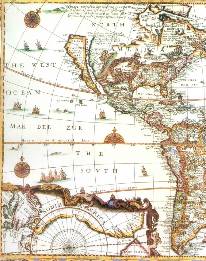
lesson ThRee

lesson aCTiviTies
Teacher Background
Juan Rodríguez Cabrillo lived towards the end of what historians call “The Age of Explo-
ration.” This lesson will help you give students some background about the exploration
that took place and geographical understanding during Cabrillo’s time.

Activity One: Exploration
Part One: Reviewing Exploration?
       A.     Have students review their definitions of “explore” from Lesson Two.
       B.     Write “discover” next to “explore” on the board. Define “discover?” Oth-
              er than finding a new place, what are some other types of discoveries?
              Possible answers: You can discover:
              •         something about the past (through artifacts, documents, photos,
                        old journals, etc.)
              •         something in the microscopic world
              •         something about or in space
              •         a scientific fact, such as a cure for a disease
       C.     Ask: “If you were exploring a new land, what might you be looking for?”
       D.     Writing: Something unexplored is sometimes referred to as a new frontier.
              What do you want to explore? What do you hope to discover?
       E.     Exploration motives. Continue your review of explorers/conquistadors by
              asking students to review the reasons that explorers crossed the oceans to
              find and conquer new lands. Reasons the students may offer from prior
              knowledge: Explorers sought to seek land (for themselves or the king),
              riches, spices, adventure, trade opportunities, native people to convert to
              Catholicism. Do not supply answers. Rather, leave the list posted in the
              room and remind students to make suggestions throughout the unit as
              they find other reasons.
Part Two: Early Explorers
Prior knowledge: Have students look at a present-day map or globe. Remind them
that we are studying the “Age of European Exploration.” Have them locate Europe and
their own location.
       A.     Have students cut out the slips of paper with explorer’s names in Hand-
              out 3-A-1 and place them on an outline map of the Americas (Handout
              3-A-2) according to what the explorer is given credit for “discovering.”
              Tell students that some explorers reached only one “New World” destina-
              tion while others reached more than one. Have students start by placing
              names they have already studied in class and then have them research the
              others as time permits. If time is short, you can provide them with destina-
              tions for the names they have not studied as per the list on page 83.

80     In Search   of   cabrIllo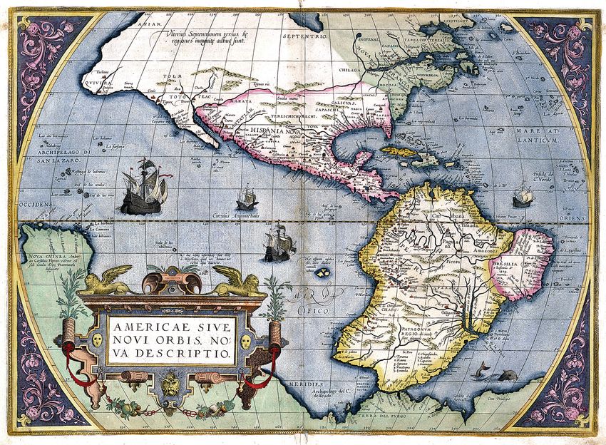
lesson ThRee

            Extension Activities:
            An additional outline map of the “Old World” is provided which could
            be put side-by-side with the destination map so students can draw in the
            routes the explorers took on their voyages. If you have the supplies to cre-
            ate a larger outline map, the activity can be done as a class or in groups.
            To enhance students’ understanding of chronology, have them create in-
            dex cards with the explorers’ names and create a timeline. This can be a
            group activity with the cards placed in sequence around the room.
      B.    After students have filled out their outline map, say “It is 1541—what is
            still left to explore in the Americas?”
      C.    Show students the map Document 3-B, “The People in the Americas be-
            fore Columbus.” Discuss whether the explorers were “discovering” the
            New World or not. Be sure to discuss both points of view—to them, it was
            a new land, but to the natives it had long been discovered.

Activity Two: Early Maps
Part One: Mapping from a Travel Narrative
      A.    Introduce the idea of maps based on travel narratives by having students
            write a story detailing either their journey to school, how they get from
            their classroom to the cafeteria, or another similar trip that might better fit
            your class. They should describe as many details as they can from begin-
            ning to the end of their trip. Tell them to include such details as descrip-
            tions of distances, what they see on the way, and left or right turns. If
            desired you can tell them about the project the day before, instruct them
            to try out the journey, and then use class writing time the following day
            to write the travel narratives.
      B.    Have students exchange travel narratives. Using the details from their
            partner’s narrative, each student should draw a map based on the descrip-
            tions. When they are finished, post the finished maps around the room
            and give students time to look at other maps. Discuss the process:
            1.     What was difficult about drawing a map just from the description?
            2.     Did anyone recognize some of the details in the narrative they
                   used? If so, did that help?
            3.     Did they look at the map that was based on their own travel narra-
                   tive? How accurate was it?

                                                         In Search   of   cabrIllo     81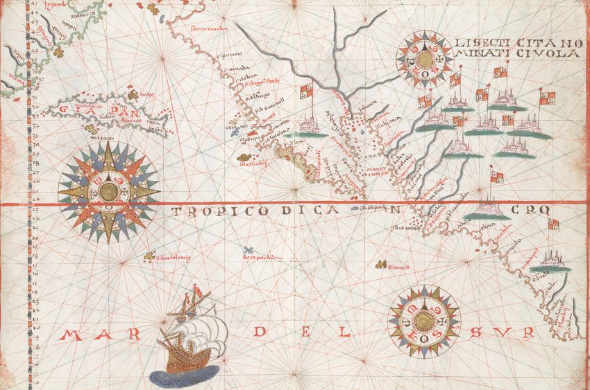
lesson ThRee

                               Teacher Guide to Explorers

                Explorer                                Destination(s)
                                                     (contemporary names)
         Christopher Columbus                 First voyage: Bahamas archipelago;
                                                     Cuba; Hispanola; Haiti
                                              Second voyage: Lesser and Greater
                                               Antilles; Puerto Rico; Dominican
                                                       Republic; Jamaica
                                               Third voyage: Hispaniola (again)
                                            Fourth voyage: Haiti; Jamaica; islands
                                              off the coast of Honduras; the east
                                             coasts of Honduras; Nicaragua, and
                                               Costa Rica; east coast of Panama
            Juan Dias de Solis                     Brazil; Uruguay; Argentina
          Pedro Álvares Cabral                                Brazil
            Amerigo Vespucci                        Coast of South America
           Rodrigo de Bastidas                               Panama
                   and
             Juan de la Cosa
         Vasco Nuñez de Balboa                 West coast of Panama; the Pacific
                                                            Ocean
     Francisco Hernandez de Cordoba            Yucatan; Nicaragua; and Granada
               Juan de Grijalva                             Mexico
         Hernando (Hernán) Cortés                  Cuba; Mexico; Honduras
             Pedro de Alvarado                    Guatemala and El Salvador
             Francisco Montejo                             Yucatan
             Pánfilo de Narváez                              Cuba
       Alvar Nuñez Cabeza de Vaca              Texas; Arizona; and New Mexico
              Francisco Pizarro                              Peru
          Sebastian de Benalcazar                          Ecuador
             Pedro de Mendoza                              Paraguay
           Francisco de Orellana                         Amazon River
      Francisco Vásquez de Coronado         (from Mexico): Arizona; New Mexico;
                                              northern Texas; western Oklahoma;
                                                            Kansas

82     In Search   of   cabrIllo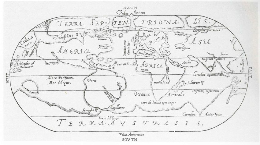
lesson ThRee
Part Two: Examining Early Maps
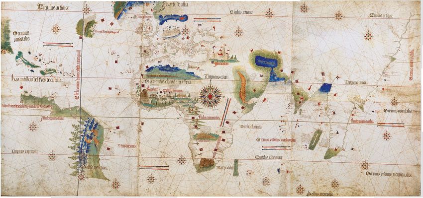
A. Show students Document 3-C, the Planisphere Cantino. This is the earli-
est surviving map that shows Portuguese “discoveries” in the New World.
Have students refer back to their explorers’ timeline and maps and note
what explorers had already reported back to Portugal. Have them note
that the mapmaker might have had access to knowledge from Columbus
and Cabral travel narratives.
Background
The most important manuscript map surviving from the early “Age of Dis-
covery,” the Cantino World Map is named for Alberto Cantino, an Italian
diplomatic agent in Lisbon who obtained it in 1502 for the Duke of Fer-
rara. The author of the map is unknown, but it was drawn in Portugal. It
incorporates extensive new geographical information based on four series
of voyages: Columbus to the Caribbean, Pedro Álvarez Cabral to Brazil,
Vasco de Gama followed by Cabral to eastern Africa and India, and the
brothers Corte-Real to Greenland and Newfoundland. Except for Colum-
bus, all had sailed under the Portuguese flag.
B. Discussion questions:
• Locate Brazil and the Carribean islands on the Planisphere map
and compare to the present-day map of Brazil and the Carribean.
• What is the same about the Planisphere and present-day maps?
Different?
• What would cause them to be different?
• What other features does the map include? [Help students note
the decorative items and labels.] What purpose might these serve?
• How did their experience with their own “travel narrative” maps
help them understand the difficulties early mapmakers might have
had?
C. Assign one of each of the following maps in Document Set 3-D to small
groups. Each group should complete the “Map Worksheet” for their map
then prepare a short class presentation about the map and its features
based on their answers. Explain to students that maps had different pur-
poses. Some were practical—strictly made for navigation—while others
were more decorative and meant to be valued for their artistic qualities
in addition to the geographic information. Maps were also a means of at-
tracting finances. If the area could be made interesting enough, then men
might want to invest in further travels.
In Search of cabrIllo 83lesson ThRee
Additional Discussion Questions:
Map One: Cosmographiae Introductio (Martin Waldseemüller, 1507)
1. Who is featured on the right side of the map? Why would Martin
Waldseemüller honor this person?
2. This map was drawn over 500 years ago. What similarities and dif-
ferences do you see between it and maps we use today?
3. If you were an explorer looking at this map in 1507, would you
think it would be easier to get to Asia by sailing above the Ameri-
can continent, or below it?
Map Two: Map prepared in connection with the Hernán Cortés exploration
of present-day Baja California (1535)
1. This map was drawn based on an actual voyage. How does it com-
pare to the travel narrative maps you and your class made?
2. Do you think someone could use this map to find their way to the
tip of Baja California?
Map Three: Map published as part of Discourse of a Discoverie for a New Pas-
sage to Cataia (Debate about a Discovery for a New Way to China)
Humphrey Gilbert, 1576)
1. According to the caption, where is the mapmaker from? How do
you think that influences how he drew the map?
2. According to the caption, the mapmaker believed that he could
sail from England, go above the North American continent, and
then reach China. How does his belief influence how he drew his
map?
Map Four: America Sive Novi Orbis (Abraham Ortelius, 1570)
1. How do you think that Ortelius’ approach to mapmaking show in
the way he drew this map?
2. Review the map showing explorers’ destinations from Activity
One, Part Two. Do you think this 1570 map reflects information
from most of those voyages?
Map Five: Chart of North-West America (Joan Martines, 1578)
1. What is the most prominent feature on this map?
2. Is this feature a real place? Why might the mapmaker include this
on his map?
Map Six: Untitled (California as an island in a printed map of America) (John
Overton, London, 1668)
1. According to the caption, Overton relied on the work of other
mapmakers to create and publish his maps. How do you think that
influenced how he drew his maps?
84 In Search of cabrIllohandout 3-a-1
Christopher Columbus Christopher Columbus Christopher Columbus
Christopher Columbus Christopher Columbus Christopher Columbus
Christopher Columbus Christopher Columbus Christopher Columbus
Christopher Columbus Christopher Columbus Christopher Columbus
Juan Díaz de Solis Juan Díaz de Solis Juan Díaz de Solis
Pedro Álvares Cabral Amerigo Vespucci Vasco Nuñez de Balboa
Pedro Álvares Cabral Amerigo Vespucci Vasco Nuñez de Balboa
Rodrigo de Bastidas &
Francisco Montejo Juan de Grijalva
Juan de la Cosa
Rodrigo de Bastidas &
Francisco Montejo Juan de Grijalva
Juan de la Cosa
Francisco Hernandez de Hernando (Hernán)
Alvar Cabeza de Vaca
Cordoba Cortés
Francisco Hernandez de Hernando (Hernán)
Alvar Cabeza de Vaca
Cordoba Cortés
Francisco Hernandez de Hernando (Hernán)
Alvar Cabeza de Vaca
Cordoba Cortés
Pedro de Alvarado Panfilo de Narvaez Francisco Pizarro
Pedro de Alvarado Panfilo de Narvaez Francisco Pizarro
Sebastian de Benalcazar Pedro de Mendoza Francisco de Orellana
Sebastian de Benalcazar Pedro de Mendoza Francisco de Orellana
Francisco Vásquez de Francisco Vásquez de Francisco Vásquez de
Coronado Coronado Coronado
Francisco Vásquez de Francisco Vásquez de Francisco Vásquez de
Coronado Coronado Coronado
cabrIllo 85handout 3-a-2 86 In Search of cabrIllo
handout 3-a-2

In Search   of   CaBrIllo   87
handout 3-a-2

88   In Search   of   cabrIllo
doCuMent 3-B

                  The Peoples of the Americas before Columbus

                                          No one was in the Americas to count how many
                                          native peoples were there before Europeans
                                          came, so anthropologists study various factors to
                                          estimate what the population was before 1492.
                                          The bars and numbers below represent low and
                                          high estimates of the population. For example,
                                          there were at least 900,000 people north of the
                                          Rio Grande and perhaps as high as 12,500,000.

Based on a graphic by Steven Rountree in Lewis Lord, “How Many People Were Here Before Colum-
bus?” U.S. News & World Report (August 10, 1997)

                                                           In Search   of   CaBrIllo      89
Cantino Planisphere
90
doCuMent 3-C
In Search
of
cabrIllo
This digital version of the Planisphere map was created by Jonathan Crowe, author of The Map Room, a blog about maps.
Available: http://pics.livejournal.com/jucundushomo/pic/0000638c/doCuMent set 3-d Map worksheet
Map Worksheet
1. What features does the map have? (You might need a magnifying glass!)
¨ Compass ¨ Scale ¨ Handwritten notes ¨ Title
¨ Name of mapmaker ¨ Legend/key ¨ Country borders
¨ Physical features (such as mountains, rivers, lakes, or features such as cur-
rents, wind patterns) List:
¨ Decorations/illustrations ¨ Measurements/directions
¨ Place names—can you read them? What is the date of the map? Is the date
listed on the map itself?
2. Why do you think this map was drawn? What evidence in the map gives you that
idea?
3. Who might use this map?
4. Compare the map to a present-day map of the Americas (western hemisphere). List
the things that are
A. The same:
B. Different:
5. Most of the maps are not done in English. Find at least two names or words on the
map that you can identify and at least two words or places that you do not know.
6. What questions do you have about the map? This could be something you would
want to ask the mapmaker or a question about any feature of the map.
In Search of CaBrIllo 91Map One
92
Martin Waldseemüller, Cosmographiae Introductio (1507)
In Search
of
doCuMent set 3-d
cabrIllo
Martin Waldseemüller was a cartographer who lived from 1475-1522. Waldseemüller is particularly famous for the map
he created in 1507. This map was the first to label the American continent “America,” a name the mapmaker used to honor
Map one
Amerigo Vespucci. At the time of its publication, no westerner was known to have visited the Pacific side of this continent.doCuMent set 3-d Map two
Map prepared in connection with the Hernán Cortés exploration
of present-day Baja California (1535)
Hernán Cortés led many conquests and explorations in the New World, including
Cuba and, most well-known, the conquest of the Aztecs of Tenochitlán. Once the
Spanish government set up control of Mexico and most of the Aztec riches, Cortés
hoped to find other riches or at least a passageway to the Indies. The earliest manu-
script map of any part of California was attached to an enactment of taking posses-
sion of present-day Baja California by Cortés on May 3, 1535. He started a colony he
named Santa Cruz (near present-day La Paz). In the peninsula can be seen the last part
of the word “Cruz.” The southernmost tip of Baja California still has a village named
Santiago.
In Search of CaBrIllo 93Humphrey Gilbert
94
Map in Discourse of a Discoverie for a New Passage to Cataia [China] (1576)
In Search
of
doCuMent set 3-d
cabrIllo
Sir Humphrey Gilbert was an English scholar and soldier who became famous as a navigator and explorer. He believed
there was a northwest passage by water across the North American continent that would lead to the East Indies. He wrote
an essay about his theory in 1576. Cataia was a name for modern-day China.
Map threeAbraham Ortelius, America Sive Novi Orbis (1570)
doCuMent set 3-d
In Search
of
The back of the map has 70 notes about the mapmakers sources
and research [http://www.orteliusmaps.com/book/ort_text9.html]
CaBrIllo
Abraham Ortelius was a Dutch geographer and cartographer. He published a world atlas, Theatrum Orbis Terrarum,
which was probably the first collection of maps in the shape of a book. Unlike most mapmakers of his time, he noted his
sources of information, including other mapmakers.
95
Map four“North Pacific Ocean, including coasts of Mexico, California, Asia, and Japan”
96
Joan Martines, Portolian Atlas (ca. 1578)
In Search
of
doCuMent set 3-d
cabrIllo
Joan Martines was a mapmaker, possibly from Mallorca, Spain which had a cartographic school. He produced more than
thirty charts and atlases between 1550 and 1591.
Map fIvedoCuMent set 3-d Map sIx
“California as an Island in a Printed Map of America”
John Overton, London, 1668
The text by “Iland of California” reads: This
California was in times past thought to beene
a part of continent and so made in all maps
but by further discoveries was found to be
An Iland long 1700 leagues.
The son of a tailor, John Overton (1640-1713) became a printer after an 8-year appren-
ticeship. He purchased the shop and collection of mapmaker Peter Stent and later the
copper-plates of another mampmaker, John Speed. Overton created map sets based on
the works of others. He published between the mid-1660s until 1707 when he sold his
stock to his son, Henry.
In Search of CaBrIllo 97You can also read