Kanata West Overall Monitoring Plan - City of Ottawa
←
→
Page content transcription
If your browser does not render page correctly, please read the page content below
Kanata West Overall Monitoring Plan April 1, 2016

             Kanata West Overall Monitoring Plan
Background

On November 24, 2009 the Ministry of Environment advised that the City of Ottawa
(City) and the Kanata West Owner’s Group (KWOG) had satisfied the requirements of
Conditions 1 and 2 of the Minister’s Order dated July 21, 2008. This clearance allowed
the City and KWOG to make preparations to proceed to Condition 3 of the Minister’s
Order – revising and updating the Class EAs for the Carp River Restoration Project, the
Master Servicing Study and the Transportation Master Plan. The Notice of Completion
for these projects was posted on July 30, 2010. In response to the Notice of
Completion, 88 Part II Order requests were received from local environmental groups,
local community groups, and members of the public asking the City of Ottawa and
Kanata West Owner’s Group be required to prepare an individual environmental
assessment for seven of the twenty-two disputed projects in the Kanata West
Transportation Master Plan Amendment, the Master Servicing Study and the Carp
River, Poole Creek and Feedmill Creek Restoration projects.

In its letter dated November 24, 2009 the Ministry requested that the City prepare and
submit an Overall Monitoring Plan Report to the MOE’s Ottawa District Office by April 1
of each year, with the first report submitted by April 1, 2010. Given the date of the letter
and the winter season the first report largely reflected the commitments contained within
the Kanata West Implementation Plan and a brief summary of the July 23-24, 2009
rainfall events. Annual results regarding stream flow and water level monitoring results
are also posted on the Mississippi Valley Conservation (MVC) website. Additional flow
monitors were installed in the spring of 2010 on Poole Creek near Maple Grove and the
Carp River at Maple Grove in accordance with the recommendations of the Third Party
Review.

Minister of Environment Decision

On March 30, 2011 the City and KWOG were notified that the Minister of Environment
had decided that an individual environmental assessment was not required for the
seven disputed projects. The Part II Order requests were denied and the following
conditions were placed on the City and KWOG:

1) The City and KWOG shall implement all commitments made in the letter of October
   15, 2009;

   a) Additional Stormwater Management Runoff Volume Controls and widening
      of Planned Restoration Corridor

   In response to Condition 1.1 of the Minister’s Order, the City and KWOG committed
   to ensuring the provision of a worst case runoff volume identified in the Third Party
   Review – Carp River Restoration Plan through at source SWM controls of 120m³ per

                                             1
Kanata West Overall Monitoring Plan April 1, 2016
hectare of development until the SWM models are validated or until monitoring
and/or model validation indicates changes are necessary; and including the
provision for 25% of the TPR worst case deficit volume be incorporated into the
design of the Carp River, Poole Creek and Feedmill Creek Restoration project.
Status: No longer required - SWM Models have been validated confirming additional
SWM Runoff Volume Controls are not required.
b) Municipal Planning Controls Regarding Floodplain Management
In response to Condition 1.2 of the Minister’s Order, the City and KWOG committed
to the application of municipal planning designations and controls with respect to
floodplain policies as set out in the City’s letter dated October 15, 2009 and in the
Implementation Plan Kanata West Development Area (Implementation Plan).
Status: Complete – Official Plan and Zoning By-law amendments were adopted by
City Council on July 11, 2012 and are in full force and effect.
c) SWM Model Validation and Contingency Plan
In response to Condition 2.1 of the Minister’s Order concerning Water Level and
Flow Modeling Data, the City and KWOG committed to completing the validation of
the SWM modeling, which includes the preparation of a Model Validation report and
the implementation of a contingency plan, as outlined in the Implementation Plan.
Status: Complete - SWM Model Validation achieved and Model Validation Report
completed in August 2011 and submitted to all agencies and posted on City’s
website.
d) Water Level and Flow Rate Monitoring Plan
In response to Condition 2.2 of the Minister’s Order concerning Water Level and
Flow Rate Monitoring Plan, the City and KWOG committed to implementing a long-
term Water Level and Stream Flow Monitoring Program, as set out in the
Implementation Plan.
Status: Ongoing – Monitoring Plan ongoing - will occur throughout the Restoration
Project.
e) Development Phasing Plan, Restoration Project Phasing and Interim
Development
In response to Condition 2.3 of the Minister’s Order concerning the Development
Phasing Plan relating to SWM, the City and KWOG committed to:
1. Adhering to development thresholds as specified in Table 1 of the
Implementation Plan;
2Kanata West Overall Monitoring Plan April 1, 2016
Status: Complete - Development Thresholds adhered to – no longer apply
based on model validation.
2. Commencing the Restoration Project within 24 months of Class EA approval
as per the Implementation Plan;
Status: Project commenced – first phase of project commenced March 2013.
3. Ensuring that each development application submitted to the City
demonstrates through an interim analysis that any incremental changes to the
floodplain/SWM Pond design will not increase water levels upstream or
downstream in accordance with the Implementation Plan;
Status: Ongoing – part of review process. and
4. Phasing of the Restoration Project and development in such a manner that
there will be no reduction in available flood storage capacity of the corridor as
set out in the Implementation Plan and the City’s response letter dated
October 15, 2009.
Status: Ongoing – Requirement of the Official Plan Policy and Zoning that
applies to the Carp River corridor and a requirement of the Carp River
Restoration Project Design and associated permits.
f) Kanata West Overall Monitoring Plan and Report
With respect to Condition 2.3 of the Minister’s Order the City and KWOG
committed to providing an Overall Monitoring Plan as specified in the
Implementation Plan that tracks and reports on all aspects of the servicing of the
development area including the following:
1. The various monitoring programs contained in the Implementation Plan;
2. The status and Progress of development including conformance with the
Development Phasing Plan;
3. The application of SWM controls and performance;
4. The results of all model validation efforts;
5. Construction phasing and progress on the Restoration Project;
6. Any contingency and adaptive management measures.
The City and KWOG have committed to preparing the overall Monitoring Plan report on
an annual basis that will be submitted to the MOE on April 1st of each year and made
available to the public and other review agencies. The 2016 report represents the
required annual report with the first report having been submitted on April 1, 2010.
Model Validation Report
Initially the monitoring program stream flow and/or water levels will be assessed to
validate the hydrologic and hydraulic models of existing/baseline conditions. Minor
changes in land use data may occur in the model, depending on the pace of
development, so that comparison of monitoring and modeling results are valid. Annual
3Kanata West Overall Monitoring Plan April 1, 2016
results regarding stream flow and water level monitoring results will be posted on the
MVC website.
The Third Party Review indicated one or two meaningful events plus smaller events can
be used to validate the model of record. Meaningful events have been described as
greater than 25 mm of rainfall within a two to six hour time period. The impact of such
an event may also be tempered by the antecedent moisture conditions prior to the event
as well.
A rainfall event on July 24, 2009 provided an opportunity to collect data for the Carp
River. This monitoring undertaken includes water level data and will be used towards
the development of rating curves for the purposes of model validation. City radar
imagery was utilized and validated by five City rainfall gauges in the watershed. Water
level information from one flow monitor has been provided by the MVC to the City for
assessment within the model recognizing that rating curves are required prior to the
event being used for validation. High-water marks were staked and surveyed in the
field and are being input into the model. Two additional flow monitors were installed on
Poole Creek and Maple Grove and Carp River at Maple Grove consistent with the
recommendations of the Third Party Review. This event and subsequent rainfalls will be
monitored and utilized by the City for validation purposes. Ultimate validation
assessment will have to ensure and document that the monitored data received is
sufficient and adequate for validation.
Since the completion of the Third Party Review the model has been updated with
new/active developments. New stormwater management facilities have been updated
from those in the original model. These and other updates will occur on an ongoing
basis as part of the City’s review role.
Condition 2 of the Minister’s Decision of March 30, 2010 also indicated that the City and
KWOG not implement SWM Ponds 1, 2, or 5 until such time as the City and KWOG
have calibrated and validated the SWM models for the Upper Carp River watershed and
prepared the associated Model Validation Report referenced in Condition 1.
In the event that the Model Validation Report identifies significant differences between
the observed and simulated results that cannot be rationalized, Condition 3 of the
Minister’s decision requires the City and KWOG to implement the Contingency Plan (as
required by Condition 1) and re-evaluate and determine the impact these changes may
have on the KWMSS and the Restoration Plan.
Since the April 2010 report an adequate number of additional rainfall events were
monitored in 2010 such that a Model Validation Report has been finalized. The report
reviews the monitoring data that was collected between 2009 and 2011and specifically
addresses:
Whether this data is sufficient to augment the original model calibration efforts
and:
4Kanata West Overall Monitoring Plan April 1, 2016
Whether the adjusted calibrated models can validate the conditions being
measured during subsequent events.
The report was finalized and reviewed by Conservation Authority and the City of
Ottawa. The final version of this report dated July 13, 2011 was submitted to the
Ministry of Environment and posted on the City’s website in August
2011(http://ottawa.ca/en/residents/water-and-environment/air-land-and-water/carp-river-
model-calibration-validation-exercise)
2016 Modeling Update
In 2014 the City initiated an update to the Carp River Subwatershed Model. The update
model was completed in late 2015 and reviewed/approved by Mississippi Valley
Conservation (MVC) and Greenland International Consulting Ltd. Greenland was the
City’s Third Party Review consultant that was engaged in response to a 2008 Order
issued by the Minister of the Environment to review stormwater management modeling
of the Carp River watershed. This exercise led to the development of a “model of
record” in 2011 that was subsequently used to support the design and approval of the
Carp River Restoration Project (CRRP).
The updated Model involved a detailed review and conversion of the previous multi-
platform model(s) of record to a single PCSWMM platform that could be used as a
practical management tool to facilitate development review in the upper watershed. The
conversion to single modeling platform was one of the key recommendations of the
Third Party Review. The new model generates results consistent with the original model
of record. The City’s update of the model was limited to the reach between the
upstream limit of the watershed and the Huntmar Drive Crossing (See Figure 2).
The existing and future condition PCSWMM models with supporting documentation are
now available on request, The year 2010 is defined as the “existing condition” while the
“future condition” represents the full build out of the remaining development areas within
the Upper Carp River subwatershed as per the City’s Official Plan, including
implementation of the CRRP.
With the completion of the updated model in 2015, the “Model Keeper” role has
transitioned back from Greenland to City Staff in Infrastructure Planning.
Thresholds
The Third Party Review identified a worst case volume of runoff that should be
accommodated in advance of the models being validated with monitored results. Based
on the Model Validation in 2011 and subsequent modeling, these at source controls are
no longer applicable or required. Modelling since the TPR confirms lower water levels.
The 1983 MVC water elevation has also been applied to provide an additional level of
protection that will meet the City’s requirements for the maximum volume in the corridor
at any time.
5Kanata West Overall Monitoring Plan April 1, 2016
The City has used the updated model to assess constraints on development with
respect to the phasing of the project. The results of this assessment demonstrate that
any works requiring the filling of the existing floodplain (SWM facilities, development
etc) must maintain total flood storage and this may require an equivalent cut until such
time as the CCRP is completed and verified in accordance with the approved
restoration design. This requirement is in accordance with the Minister’s Order, The
City’s Official Plan and Zoning policies for the CRRP, and MVC regulation policies.
Stormwater Management Monitoring
The City provides on-going monitoring of stormwater management facilities for
suspended solids, phosphorous, and temperature (if required by the classification of the
receiver). Visual inspections of SWM facilities occur after each large event (15 mm or
greater) and debris is removed as necessary to ensure proper functioning of the facility.
Routine inspections of inlets/outlets and the depth of sediment are carried out at the
same time.
Construction inspection staff regularly checks these facilities prior to the City assuming
the facilities after 80% build-out and identify any remedial measures required to be
implemented by the developer to ensure the protection of the receiving stream. An
operation and maintenance manual must be prepared and provided to the City prior to
assumption of the facility.
The following represents a standardized SWM monitoring program for the Kanata West
Area:
Monitoring Program:
1. The stormwater monitoring program shall be implemented for a minimum of two
years and shall continue to be implemented until such time that the MOE’s
Ottawa District Office provides written notice that the program may be
discontinued;
2. Monitoring will be provided during the period between May 1 st and October 31st
for water quality and water level as well as general performance. Water quality
would be established for both baseflow and rainfall event conditions;
3. Routine operational inspections would be conducted over the life of the facility, to
confirm: general site conditions (erosion/landscaping); ensure monitoring
equipment is functioning appropriately; and that orifices and weirs are not
clogged with debris. Routine cleaning of any blockages would be done during the
inspections, if required;
6Kanata West Overall Monitoring Plan April 1, 2016
4. Pond water levels would be monitored to determine drawdown characteristics of
the facility (typically 24 - 48 hours). No flow monitoring is proposed in this
program;
5. Water quality samples would consist of composite samples (collected utilizing
automated equipment or by grab sampling) taken at the facility inlet and outlet
during/after specified rainfall events. The routine inspection would typically be
conducted coincident with sample collection activities;
6. Water quality parameters would include the Total Suspended Solids (TSS) and
Total Phosphorous (TP) and Water Temperature (spot measurement);
7. The sample collection, preservation, handling and analytical methods including
detection limits, would be documented. Sample analysis to be conducted per
Standard Methods or approved equivalent at a CALA certified laboratory. Field
and lab QA/QC procedures would reflect standard sampling protocols (i.e.
samples delivered within 12 hours to lab following collection);
8. Provide monitoring (sampling, water levels) during the following events over a
two year period to ensure that the facility is performing as designed:
Two small rainfall events ( less than 7mm)
Two medium rainfall events (7-15mm)
Three large rainfall events (greater than 15mm)
9. The requirement is for a minimum of the 7 noted events of the size specified.
Monitoring activities would typically capture a number of other events during the
process, as the amount of rainfall from an event is not predictable in advance. All
events that are monitored/sampled are to be reported in the annual reports. The
sampling of all the events within a one year period, although possible, is not
acceptable as the intent is a two year program;
10. Rainfall measurements should be obtained from the nearest available City of
Ottawa rain gauge(s) to the facility;
11. A topographic/bathymetric survey should be undertaken after 3-5 years of
operation to determine sediment deposition and sediment deposition rates. This
would allow for more concise forecast of forebay cleanout frequency; either
confirming or revising the frequency in final SWM report.
Annual Stormwater Monitoring Report
The Annual Stormwater monitoring report shall be prepared and submitted to the
District Manager, Ottawa District Office of MOE within six months following the end of
7Kanata West Overall Monitoring Plan April 1, 2016
the monitoring period. The Annual Stormwater Monitoring Report shall also be provided
to the City of Ottawa’s Planning and Growth Management Department so that the City
can review and include results in its annual Overall Monitoring Report in accordance
with the Implementation Plan Kanata West Development Area; the Report is to contain
the following:
a) A description of the physical works, its location, and how it is designed to
function;
b) A tabulation, interpretation and summary of all monitoring data with an
assessment of the performance of the facility based on TSS removal including
comparison of the water quality data with applicable criteria such as the
Provincial Water Quality Objectives (PWQO’s);
c) An evaluation of the pond’s performance and its ability to meet the design
performance criteria of 70% TSS removal (during the monitoring period) and
ability to achieve an appropriate draw down time (24 – 48 hours);
d) A description of any operating problems encountered and corrective actions
taken during the reporting period and the need for further investigation in the
following reporting period for pond refinements or ways of improving the
performance of the facility to meet the performance target;
e) Any need for modifications of the monitoring program and/or the work plan;
f) A summary of any complaints received during the reporting period and any steps
taken to address the complaints;
g) Appendices of inspection logs and facility photos;
h) Any other information that is deemed to have been obtained by the Owner
pursuant to the requirements of the Certificate of Approval that the MOE District
Manager requires for inclusion in the reports.
Monitoring for Interim Stormwater Management Facilities
SWMP monitoring requirements for each facility will be identified in the Ministry of the
Environment’s Certificate of Approval for each facility. The City and MVC requires a
comprehensive monitoring program to ensure the Carp River, Poole Creek and Feedmill
Creek restoration project and preferred stormwater management solutions identified in
the Master Servicing Plan operate and perform to the specifications and standards
described in the Class Environmental Assessment documents.
8Kanata West Overall Monitoring Plan April 1, 2016
Stream flow monitoring will form an important component of the monitoring program.
The City and the MVC are committed to implementing a long-term stream flow
monitoring program for the Upper Carp River Watershed. The program will support the
mandate of the MVC, including flood forecasting. It will also be utilized, by the City of
Ottawa to confirm the current hydrologic and hydraulic models that have been
developed for the Upper Carp River Watershed. The current models contain stormwater
management proposals, including at source, stormwater management ponds and
conveyance systems that meet the water management objectives of the City of Ottawa,
the MVC, MNR, MOE and MTO. The City, along with MVC and provincial agencies,
has a vested interest in ensuring water management objectives for the Carp River
system is met.
The following additional requirements for interim SWM facilities shall be provided in
addition to the above Stormwater Management Monitoring Program requirements:
The stormwater monitoring program shall be implemented for a minimum of two
years and shall continue to be implemented until such time that the Ministry of
Environment provides written notice that the program may be discontinued;
An annual stormwater monitoring report shall be prepared and submitted to the
Ministry of Environment (Ottawa District Office) than March 31st of each and
every year. The annual reports shall cover the monitoring period for the previous
year,
The annual monitoring reports and associated data are also to be provided to the
City of Ottawa, so that the municipality can review and include the results in its
annual Overall Monitoring Report in accordance with the Implementation Plan for
the Kanata West Development Area; and
All annual monitoring reports shall include the following additional information for
the reporting period
o an estimate of baseflow from the facility;
o an estimate of the percentage of build out for the contributing drainage
area of the facility; and
o A description of any considerations that may need to be implemented
upon transition and/or decommissioning of the interim facility once an
ultimate SWM facility is provided.
Stream Flow and Fisheries Monitoring
The City of Ottawa is undertaking a comprehensive monitoring program to ensure the
Carp River, Poole Creek and Feedmill Creek restoration projects operate and perform
to the specifications and standards described in the Class Environmental Assessment
documents. An integrated monitoring program has been developed and implemented
that will include but not be limited to:
Semi-annual fisheries and terrestrial monitoring/reporting to DFO
Stream Flow monitoring
9Kanata West Overall Monitoring Plan April 1, 2016
Semi-annual fisheries and terrestrial monitoring/reporting to DFO
This monitoring will include assessment of erosion and deposition through the system
as well as any erosion/scour at major crossings including Highway 417. Observations
will be documented with field measurements and photos depicting the stabilization
process of the restoration features. In the event that specific areas demonstrate the
need for remedial action, repair or restoration will be made accordingly. The reports
would be circulated to other agencies as required. Two kinds of monitoring of the
aquatic environment are particularly relevant:
(1) Construction monitoring to ensure that the new channel and ponds are
constructed as per specifications; and
(2) Post-construction monitoring to determine whether the newly constructed
channels and ponds have indeed improved aquatic habitats.
Construction monitoring of the fish habitat compensations will be carried out to
demonstrate that proposed activities have been implemented.
Biologists, environmental inspectors, or experienced contractors will inspect the
compensation works during and after completion and will collect photographic
evidence to show that the works were completed as agreed upon in the plan and
for the purpose of an authorization under Section 35 of the Fisheries Act.
Sediment and erosion control measures will be inspected regularly and maintained in
proper working order until all areas are fully stabilized.
The City of Ottawa currently monitors water quality, fish and benthic invertebrates in the
Carp River system on a frequent basis, and it is anticipated that the City will continue to
do so following construction. The City has extensive pre-construction data – the most
recent version of the report can be found at the link below:
http://ottawa.ca/sites/default/files/carp_feedmill_poole_habitat_restoration_monitoring_report_2
012_2.pdf
Monitoring will be conducted in years 1 and 2 after full construction, then at 2
year intervals until the system is demonstrated to be stabilized. The information
gained from this monitoring will be useful for determining the success of the plan,
and may provide insight for future restoration activities in the Carp River and
elsewhere.
Monitoring will include indicators of the physical and chemical environment, as
well as of the biological responses (fish and benthos).
CRRP Construction Monitoring
Phase 1 (Richardson Side Road to Highway 417) of the CRRP commenced in January
2016. Karson Konstruction was awarded the tender for Phase 1. Phase 1 is scheduled
to be completed in May 2017 with Phase 2 (Highway 417 to Hazeldean Road scheduled
for completion in early 2018.
10Kanata West Overall Monitoring Plan April 1, 2016
Table 1 below represents the testing and monitoring undertaken during construction.
Table 1 - Testing and Monitoring
Test/Monitoring Required Frequency Responsibility
Visual monitoring of ESC Daily Karson
measures
Turbidity/TSS testing Weekly Golders
upstream & downstream of
construction site
Turbidity testing Daily Karson
downstream of active
construction site
In stream monitoring of As needed Golderies/Fisheries
fish/turtle/amphibian Specialist
salvage program
Wildlife Species monitoring Daily Karson
Wildlife Species monitoring Weekly Terrestrial/Aquatic
Specialist
During construction periods monthly water quality monitoring reports and Erosion and
Sediment Control Inspection reports are prepared by Golder and sent to the contractor
(Karson), MVC, KWOG and the City. The monthly monitoring reports summarize recent
activities, identify upcoming activities, identify any critical issues and solutions, present
the weekly water quality testing results and provide onsite photos of recent activity.
During years 1 and 2 (Post Construction), the stability of the banks, and streambed will
be assessed and any features that are determined to not be functioning as intended will
be corrected. Additional plantings and/or seeding will be applied where the
establishment of vegetation is insufficient to meet soil stability.
Stream Flow monitoring
The City and MVC are committed to implementing a long-term streamflow monitoring
program for the Upper Carp River Watershed. The program will support the mandate of
the MVC, including flood forecasting and warning. Annual results will be posted on the
MVC website.
Continuous monitoring of water level and streamflow (year round) will occur at three
locations in the Upper Carp River Watershed including the Carp River and Poole Creek.
Carp River at Richardson Side Road
Carp River at Maple Grove Road
Poole Creek at Maple Grove Road
11Kanata West Overall Monitoring Plan April 1, 2016
All of these streamflow monitoring stations are permanent gauges as part of the
ongoing MVCA long-term monitoring program. Water level data is currently being
collected and stage-discharge rating curves are being developed for each location. The
Carp River gauges closely relate to flows at MTO's 417 bridge structure. Gauges
located at Richardson Side Road and two on Maple Grove Road (one at the Carp and
one at the Poole crossing) will provide appropriate information as the flows from
Feedmill are intermittent and can be inferred from the other locations. Palladium Drive
was also considered as a replacement for Maple Grove Road location at the Carp River
which would not be affected by the future changes to Maple Grove but not selected by
the MVC for access and safety reasons. The results from the streamflow monitoring are
detailed in the Model Validation Report.
The City of Ottawa’s Water Environment Protection Program provides up to date
information on the condition of Ottawa’s surface water resources. As far as existing
monitoring sites within Kanata West the City have the following in the Baseline program:
• Carp River @ Richardson Side Rd - water quality data for 10 years;
• Carp River @ Huntmar - baseflow in 2009; biological monitoring added in 2010;
• Poole Creek upstream of Stittsville - baseflow in 2009; added as part of
expanded program in 2010 for water quality and biological; fish community
information since 2005; and
• Feedmill Creek – stream habitat assessment completed in 2004 for three areas
between the Carp River and Highway 417 (includes habitat, fish and benthos
community, thermal stability information).
The City has initiated further monitoring of the aquatic environment in the vicinity of the
restoration efforts on the Carp River, Feedmill Creek and Poole Creek to determine
restoration effectiveness. Key concepts of the Project Outline include:
• Quantitative assessments to determine restoration effectiveness;
• Pre-construction monitoring to document condition of aquatic indicators before
restoration and develop restoration effectiveness criteria
• Post construction monitoring to document condition of aquatic indicators after
restoration for comparison to criteria; and
• Post-monitoring analysis to determine changes in aquatic indicators and level of
restoration effectiveness.
Fieldwork occurred between March and November. Fish habitat assessments, benthos
community assessments, fish community sampling and assessment were carried out as
well as water chemistry sampling and water temperature monitoring. The results of the
previous work programs are provided on the City’s website and form part of the Annual
Monitoring report process (see Appendix 1). A report was not produced for 2014-15 as
the City has adequate pre-construction data to evaluate against post-construction
conditions. .Additional information on the City’s Baseline Water Quality Monitoring
Program can be found at the following link:
12Kanata West Overall Monitoring Plan April 1, 2016
ottawa.ca/calendar/ottawa/citycouncil/pec/2007/08-28/ACS2007-PWS-UTL-
0014%20-%20ENG.htm
Water Demand Monitoring
A regular water demand monitoring program will be required to accurately identify
the timing of the construction of upgrades to the sub-pressure zones. All infrastructure
will be included in the City infrastructure management program. Infrastructure under
developer warranty will not be included in this program.
The watermains are associated with the area arterial and collector roadway construction
and watermain looping needs to service adjacent and proposed development. The
timing of the proposed transmission watermains is subject to the timing of the local
developments they serve and the construction timing of the transportation network.
Looping of the watermain is required in the lands south of the 417 at 1000 units and
north of the 417 at 500 units. Design and construction for both the north and south
watermain looping has been completed
Sanitary Monitoring
A regular flow monitoring program will be performed by the City to accurately identify
the timing of the various upgrades to the Signature Ridge Pumping Station (SRPS)
required to facilitate the development of Area “A” (Kanata West Master Servicing Plan -
MSS). The hydraulic analysis in Master Servicing Study uses current City design
guidelines to demonstrate that Phase IA can build out within the design capacity of the
upgraded SRPS. A minor upgrade including overflow for the Signature Ridge Pump
Station has been constructed.
Area “B” as shown on the MSS includes the area within Kanata West which will be
tributary to the new pumping station to be built on Maple Grove Road west of the Carp
River. This pumping station will drain to the Stittsville Collector Sewer on an interim
basis via a temporary forcemain in Maple Grove Road, Huntmar Road and Iber Road.
All of Area “B” will not be able to be tributary to the Stittsville Collector on an interim
basis and a regular flow monitoring program is required to determine the exact amount
of development which will be allowed into the Stittsville system on an interim basis.
A regular flow monitoring program is in place for the Stittsville system to accurately
identify development needs and capacity use.
The new Kanata West Pump Station and associated forcemains and overflow are
currently under construction which is scheduled to be completed in 2018.
Development – Timing and Phasing
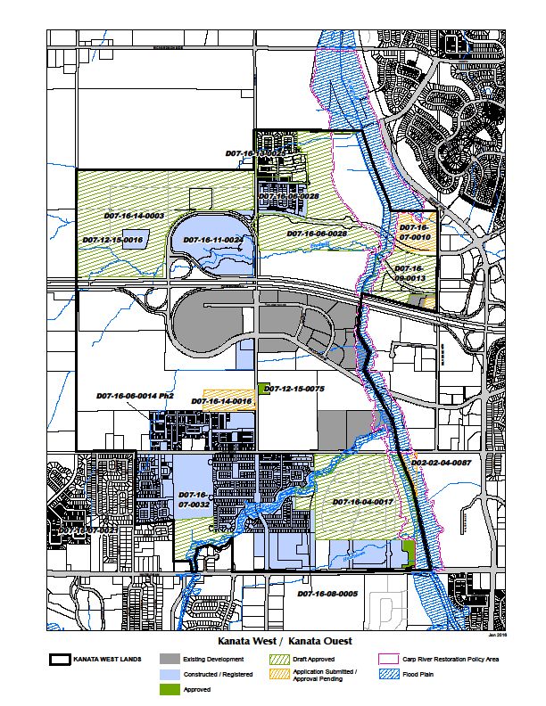
As of April 1 2016, a limited amount of development within Kanata West has
commenced. Figure 1 illustrates the status of developments in Kanata West. Given the
13Kanata West Overall Monitoring Plan April 1, 2016
delays incurred throughout the Kanata West Environmental Assessment process and
based on existing sanitary sewer capacity constraints and significant land and SWM
ponds tied to the Carp River Restoration, there has been limited development in the
Kanata West area to date.
The Kanata West Area is comprised of approximately 722 hectares of urban land. A
total of approximately 73 hectares of land represents “existing development” (i.e.
Scotiabank Place, Palladium Auto Park, Maple Grove Works Yards, and the Bridge
Church). A total of 161hectares is made up of constructed or registered residential lots
including the retail areas along Hazeldean Road and north of Highway 417 and the
Fairwinds North and South subdivisions along Maple Grove Road and the Arcadia
subdivision to the north. An additional 2.6 hectares of land has been approved but not
yet constructed. In terms of constructed, registered and ready to develop land, a total of
164 hectares exists in Kanata West which represents approximately 23% of the total
land area. In addition, a further 204 hectares of development land has been draft
approved. Much of this land cannot be developed until the Kanata West Pump Station
has been commissioned or the Carp River Restoration Project has been completed. In
terms of draft approved and registered lands a total of 368 hectares exists within Kanata
West representing 51% of the total land area in Kanata West.
Applications have been received for a further 19 hectares of land for which draft
approvals have not been granted and final approval/construction will be some time
based on servicing constraints (Sanitary Pump Stations, SWM ponds).
14Kanata West Overall Monitoring Plan April 1, 2016
Figure 1
Status of EA Projects
There were 22 projects approved through the three Environmental Assessment Studies,
seven of which were subject to Part II Order requests in response to the June 2006
Notice of Completion. The other 15 were deemed to be approved and could proceed to
construction in accordance with the Class EA process. In July of 2010 a new Notice of
Completion was filed for the 7 disputed projects and the four roadway projects that had
not as of yet commenced. On March 30, 2011 the Minister of Environment issued a
15Kanata West Overall Monitoring Plan April 1, 2016
decision dismissing the subsequent Part II Order requests to the July 2011 Notice of
Completion. Table 2 lists the 22 projects, provides an indication of their current status
and when the deadline for commencement of the project is based on the date of the
corresponding Environmental Assessment Process (10 years from 2006 or 2011).
TABLE 2
Project Implementation Status Deadline for Project
Commencement before
EA Update Required
Master Servicing Study
Water Projects
Watermains in Huntmar Road Watermain in Huntmar Road N/A construction started
Extension from Halzeldean Road constructed
to Maple Grove Rd.
Watermains in Huntmar Road Part of project started in 2013 N/A construction started
Widening from Maple Grove Road completion in 2015
to Campeau Drive
Watermains in Campeau Drive Construction Completed N/A construction started
from Didsbury Road to North
South Arterial
Watermain in Maple Grove Road Watermain in Maple Grove N/A construction started
from Stittsville Main Street to Terry Road partially constructed
Fox Drive
Watermains in North-South Not started 2016
Arterial from Hazeldean Road to
Campeau Drive Extension
Watermains in Stittsville Main Not started 2016
Street Extension from Maple
Grove Road to Palladium Drive
Stormwater Projects
Stormwater Management Pond # Partial Trunk Sewer N/A construction started
1 and associated storm sewers Constructed
Stormwater Management Pond # Design Started 2021
2 and associated storm sewers
Stormwater Management Pond # Construction Completed N/A
3 and associated storm sewers
Stormwater Management Pond # Partial trunk storm sewer along N/A
4 and associated storm sewers Maple Grove constructed,
Partial SWM Pond constructed
Stormwater Management Pond # Design Started 2021
5 and associated storm sewers
Stormwater Management Pond # Construction Completed N/A
6 and associated storm sewers
Stormwater Management Pond # Not started 2021
7 and associated storm sewers
Sanitary Projects
Signature Ridge Pump Station Construction Completed N/A
Upgrade and associated gravity
16Kanata West Overall Monitoring Plan April 1, 2016
sanitary sewers
Kanata West Pumping Station and Under Construction – project N/A construction started
associated gravity sanitary sewers completion 2018
- Permanent Twinned Force
main to the Tri Party
Collector
- Trunk Sanitary from Silver
Seven, & along Carp River
between Maple Grove
Road and Palladium Drive
Transportation Master Plan
Huntmar Road Extension from Construction Complete N/A construction
Halzeldean Road to Maple Grove completed
Road
Campeau Drive from Didsbury Construction commenced – N/A construction started
Road to North-South Arterial eastern leg constructed
Huntmar Road Widening from Not started 2021
Maple Grove Road to Campeau
Drive
Maple Grove Road Widening from Not started 2021
west of Huntmar Road to Terry
Fox Drive
North-South Arterial from Not started 2021
Hazeldean Road to Campeau
Drive Extension
Stittsville Main Street Extension Not started 2021
from Maple Grove Road to North-
South Arterial
Transitway Transitway EA completed N/A no expiry for TPAP
Carp River, Poole Creek and Feedmill Creek Restoration
Carp River, Poole Creek and Project Commenced March N/A construction started
Feedmill Creek Restoration 2013.
Timing of Annual Report
This reporting will occur on an annual basis (April 1st). The report will be sent to the
local MOE office and posted on the City’s website at the following link:
http://ottawa.ca/en/residents/water-and-environment/carp-river-
watershedsubwatershed-study
17Kanata West Overall Monitoring Plan April 1, 2016
Note: Due to its technical nature, this report is available in English only. The City of
Ottawa may translate this report or parts thereof on request. Requests for translation
should be forwarded to Don Herweyer at 613-580-2424, ext. 28311 or to the French
Language Services Division at DSF-FLSD@ottawa.ca or 613-580-2424, ext. 21536.
18You can also read